Here's something you might be interested in.
Ask a Hipster — Advice you didn't know you needed
Big Screen — Movie commentary
Blurt — Music's inside track
Booze News — San Diego spirits
Classical Music — Immortal beauty
Classifieds — Free and easy
Close to Home — What it’s like on the street where you live
Cover Stories — Front-page features
Drinks All Around — Bartenders' drink recipes
Excerpts — Literary and spiritual excerpts
Feast! — Food & drink reviews
Feature Stories — Local news & stories
Fishing Report — What’s getting hooked from ship and shore
From the Archives — Spotlight on the past
Golden Dreams — Talk of the town
The Gonzo Report — Making the musical scene, or at least reporting from it
Letters — Our inbox
Movies@Home — Local movie buffs share favorites
Movie Reviews — Our critics' picks and pans
Musician Interviews — Up close with local artists
Neighborhood News from Stringers — Hyperlocal news
News Ticker — News & politics
Obermeyer — San Diego politics illustrated
Outdoors — Weekly changes in flora and fauna
Overheard in San Diego — Eavesdropping illustrated
Poetry — The old and the new
Reader Travel — Travel section built by travelers
Reading — The hunt for intellectuals
Roam-O-Rama — SoCal's best hiking/biking trails
San Diego Beer — Inside San Diego suds
SD on the QT — Almost factual news
Sheep and Goats — Places of worship
Special Issues — The best of
Street Style — San Diego streets have style
Surf Diego — Real stories from those braving the waves
Theater — On stage in San Diego this week
Tin Fork — Silver spoon alternative
Under the Radar — Matt Potter's undercover work
Unforgettable — Long-ago San Diego
Unreal Estate — San Diego's priciest pads
Your Week — Daily event picks
A water war heats up on Palomar Mountain
Drilling in on a little piece of Oregon
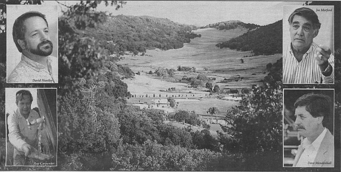
Mendenhall Valley, Palomar Mountain
Left to right, top to bottom: David Huntley, Joe Morford, Ray Carpenter, Dave Mendenhall. “If the lowlanders of Escondido take our water to sprinkle their lawns, it’s not just our wells that will suffer."
Left to right, top to bottom: David Huntley, Joe Morford, Ray Carpenter, Dave Mendenhall. “If the lowlanders of Escondido take our water to sprinkle their lawns, it’s not just our wells that will suffer."
The Romans are at the bottom of the mountain redoubt, their awesome machines of war gathering, building a ramp up to the 5000-foot-high fortress....
The fortress is Palomar Mountain. The “Romans” are the Samda water-mining company — at least that’s how its opponents, a group of residents on Palomar Mountain, view it. Samda is an Oklahoma company that uses satellite imagery to locate water sources. It wants to put down deep wells and extract up to 5000 acre-feet of water a year from the belly of Palomar Mountain to supply to the Vista Irrigation District, the “lowlanders” of Escondido and San Marcos. Members of the Palomar Mountain Planning Organization, a citizens’ group representing about 700 property owners on the mountain, fear the extraction of that amount of water will dry up not only their own wells, but also destroy the ecology of what they call California’s richest and most fragile wildlife reserve.
“If they take that,” says Ray Carpenter, an engineer specializing in hydraulics who lives on the mountain, “it will be a hydraulic clear-cut. Let me show you what I mean.”
We’re on top. Green, Shangri-la valleys scoop between thick-forested mountain ridges. This is Heidi, Julie Andrews country. “The hills are alive...”
Actually, the sound is of thousands of raucous crows; the big black birds come up here in the late summer to confuse the local woodpeckers and steal all the acorns they’ve stored for winter.
The symbolism is not missed on Carpenter. “If the lowlanders of Escondido take our water to sprinkle their lawns, it’s not just our wells that will suffer. A whole lot of living things will too. They want to draw from 2000 feet down. They say their supply could be endless and wouldn’t affect us up here. But what happens when you draw water out of the bottom of a reservoir? The water at the top drops down to replace it. No more pressure for our springs, nothing to hold our groundwater up.
“Palomar is an extraordinary ’island.’ A little piece of Oregon that somehow ended up in the California desert. At our base, the elevation is 700 feet above sea level. Then Palomar. This wall of granite shoots up 5000 feet. You’re in another land up here. We’re temperate. We get four to ten feet of snow in winter. We have spring, fall.”
And rain. What Carpenter calls Palomar s “monsoon season” starts in October. The clouds that come off the Pacific and scud over Camp Pendleton suddenly bump into that granite face. They quickly rise up the 5000 feet, cooling four degrees every 1000 feet. “By the time they reach the top,” says Carpenter, “they’ve cooled 20 degrees and they’re ready to drop as rain. San Diego County averages 9 inches of rain a year. Up here on Palomar we get 48 inches.”
But the mountain needs it all, says Carpenter. “Palomar Mountain has a greater concentration of wildlife than any other place in Southern California, flora and fauna. This is how California was. The delicate balance of forests, the mountain lion, the white-tailed deer, the last wild run of native rainbow trout, thousand-year-old trees.... If the water table drops, our forests will become like the scrub that grows below 2000 feet. And us too, the people living on top of the mountain. Our water supply is endangered too. We’re all going to be the losers. That’s what we’re fighting this afternoon.”
He is on his way to a meeting between the irrigation district and the Palomar group being held in the local volunteer firehouse.
It’s 2:00 p.m., Saturday, September 24th. People are hurrying out from the trees and crunching across the gravel towards the volunteer fire brigade shed.
Facing maybe 50 of the mountain’s 300-odd permanent residents locals is Joe Morford II, president of Samda, Vista Irrigation District officials, and a meeting-facilitating group. Seated at the back is the lone rancher, Dave Mendenhall. He is Samda’s partner in this venture. The drilling will take place on his property. The profits of the money paid for the water by Vista Irrigation District — which some estimate in millions per year — will be shared between him and Samda.
It’s a heated meeting. Morford explains that his company has successfully opened up 17 deep wells in Saudi Arabia and others in Yemen and Nigeria. Here he is only interested in doing exploratory wells, shallow at first and then to 2000 feet, to see if there is good water down there; and secondly, to see if it can be extracted without adversely affecting shallow wells and springs elsewhere on the mountain.
“At 5000 acre-feet a year, how is that water going to be replenished?” asks George Ravenscroft, whose Palomar Spring Water Company already takes drinking water from the mountain, but only from surface springs, and at a rate, he says, that allows for replenishment. “And how can you prove that the water you take comes only from the Mendenhall ranch? You’re talking about this deep reserve of water as if it were the ‘Lost Water Of Atlantis.’ It’s not. It’s rainwater that falls on Palomar Mountain. All of it. Before you do anything, we want an environmental-impact report.”
Morford says he is only asking for two to three years to do tests to see if the project is viable. “How can you test a plane without flying it?” he asks.
“Yes, but you don’t test an airplane over a residential neighborhood,” says one of the audience, to a rousing round of approval.
“You could be doing 50 years’ damage in that two to three years,” says Carpenter, standing up. “This mountain is an anomaly. A piece of Northern California sticking up out of the California desert floor. Water is the basis for all our wildlife up here. We live here. You can go back to Oklahoma. If we lose it it’s gone. What you’re proposing is a de-watering program which takes from all of us but only benefits two of you. Why won’t you agree to an EIR [Environmental Impact Report]?”
“We want to test it first,” says Morford, “so we know if it’s worthwhile proceeding.” “And what if your tests do damage this environment? What if it takes time for the damage to show up, like the 20 to 30 years it takes for a 1000-year-old oak to die for lack of water? You’ll be long gone. We don’t want you to test.”
Outside in the gravel, after the meeting, Dave Mendenhall stands to the side with his wife. “Yeah, I’m the guy ‘ram-rodding’ this project,” he says. “I live here. My family has since 1869. This is happening on my property. But I called the meeting, for the public interest. The only reason we’re going through this crap is because the water would be used for VID, a public body. If this were an agricultural well, there’d be none of this.” Mendenhall says the first thing he asked Samda when they approached him four years ago was how this would affect the mountain. “Because regardless of what Samda does, it all boils down to what are we going to go along with. Our family does have control of this situation, not Samda.”
Mendenhall sees a bit of hypocrisy among his often-wealthy neighbors. “I’ve got ‘vanity farmers’ near me who spray their fields all day just so they can have pretty green meadows to look at. That has dried up a lot of my water downstream. Yes, I’m looking at making money from drilling water. And I can’t be responsible for what happens 30 to 50 years down the line. I don’t think anybody can. But I live here. My family has (lived here) longer than any of these people. And it’s in my contract with Samda: I have to be convinced there will be no effect on Palomar Mountain’s ecology, or my neighbors, before I agree to any pumping. I don’t think these people understand this.”
Behind this battle is the battle of the experts. The Palomar group brought two of them to the meeting, written opinions in hand, both say that the testing program carries dangers for Palomar’s life-systems. “This project has the potential to substantially degrade the quality of the environment on Palomar Mountain,” says Brian F. Mooney, whose company specializes in environmental studies and resource management. He says the irrigation district’s plan “compromises the long-term environmental goals of one of the most environmentally sensitive regions of both the county of San Diego and the state of California: Palomar Mountain.”
Bruce Graves, a professor of geological studies at SDSU suggests that a deep well would need to gather recharge water from an area far larger than Mendenhall’s 400-acre ranch. “Wells drilled [to pump the ultimately hoped-for 5000 acre-feet of water per year] would have to intersect fractures that draw upon the groundwater under 10,000 to 25,000 acres.”
But San Diego County groundwater geologist John Peterson, who visited Mendenhall’s ranch last June 21, has written to him that “the shallow-well testing is of short duration and is not likely to produce adverse environmental impacts (and] should not require environmental review.” Peterson says a decision on the environmental impact of the deep-well testing can be made “at a later date”.
It’s dusk. Ray Carpenter is back on his property, which overlooks Mendenhall’s ranch. “I want to show you something,” he says. He points to one of the glorious alpine meadows slung between two rows of peaks. In the distance, a family of wild white-tailed deer graze. But he’s not looking at them. “See those gouges, where the ponds are?” He points to what look like two giant tank-tracks through the middle of the valley. “Those are what happened here the first time man interfered. In 1917, Teamsters cut the trees out of the valley to grow pasture to feed their cattle. That winter, storms came and gouged out those two ditches. Thirty feet deep and 70 feet wide. The valley has never fully recovered. Then there was the fire of ’87. Started by a lowland orchardist. Burned 40 percent of the forests on this mountain. It’ll be hundreds of years before it recovers to what it was. That is what happens when man interferes.”
Finally, we’re outside in “his” forest. Oaks and firs a thousand years old loom overhead. Squatting down atop a piece of granite rock, you notice a round hole in the rock. A mortero/matate — a manmade bowl where, until Europeans arrived, women ground acorn hearts into a paste for bread. “People have been coming and living here for 5000 years. We have a responsibility here. After all this time I don’t want our generation to be the one that wrecks this little island of paradise.” Dave Mendenhall, meanwhile, says he’ll call another meeting just to drive home the point that he is not intent on wrecking the mountain. Is he surprised at the passion his scheme has aroused? “Not at all,” he says. “Like Mark Twain said: ‘Whiskey’s for drinking and water’s for fighting over.’ ”
Here's something you might be interested in.
A water war heats up on Palomar Mountain
Drilling in on a little piece of Oregon
A water war heats up on Palomar Mountain
Drilling in on a little piece of Oregon
Mendenhall Valley, Palomar Mountain
Left to right, top to bottom: David Huntley, Joe Morford, Ray Carpenter, Dave Mendenhall. “If the lowlanders of Escondido take our water to sprinkle their lawns, it’s not just our wells that will suffer."
Left to right, top to bottom: David Huntley, Joe Morford, Ray Carpenter, Dave Mendenhall. “If the lowlanders of Escondido take our water to sprinkle their lawns, it’s not just our wells that will suffer."
The Romans are at the bottom of the mountain redoubt, their awesome machines of war gathering, building a ramp up to the 5000-foot-high fortress....
The fortress is Palomar Mountain. The “Romans” are the Samda water-mining company — at least that’s how its opponents, a group of residents on Palomar Mountain, view it. Samda is an Oklahoma company that uses satellite imagery to locate water sources. It wants to put down deep wells and extract up to 5000 acre-feet of water a year from the belly of Palomar Mountain to supply to the Vista Irrigation District, the “lowlanders” of Escondido and San Marcos. Members of the Palomar Mountain Planning Organization, a citizens’ group representing about 700 property owners on the mountain, fear the extraction of that amount of water will dry up not only their own wells, but also destroy the ecology of what they call California’s richest and most fragile wildlife reserve.
“If they take that,” says Ray Carpenter, an engineer specializing in hydraulics who lives on the mountain, “it will be a hydraulic clear-cut. Let me show you what I mean.”
We’re on top. Green, Shangri-la valleys scoop between thick-forested mountain ridges. This is Heidi, Julie Andrews country. “The hills are alive...”
Actually, the sound is of thousands of raucous crows; the big black birds come up here in the late summer to confuse the local woodpeckers and steal all the acorns they’ve stored for winter.
The symbolism is not missed on Carpenter. “If the lowlanders of Escondido take our water to sprinkle their lawns, it’s not just our wells that will suffer. A whole lot of living things will too. They want to draw from 2000 feet down. They say their supply could be endless and wouldn’t affect us up here. But what happens when you draw water out of the bottom of a reservoir? The water at the top drops down to replace it. No more pressure for our springs, nothing to hold our groundwater up.
“Palomar is an extraordinary ’island.’ A little piece of Oregon that somehow ended up in the California desert. At our base, the elevation is 700 feet above sea level. Then Palomar. This wall of granite shoots up 5000 feet. You’re in another land up here. We’re temperate. We get four to ten feet of snow in winter. We have spring, fall.”
And rain. What Carpenter calls Palomar s “monsoon season” starts in October. The clouds that come off the Pacific and scud over Camp Pendleton suddenly bump into that granite face. They quickly rise up the 5000 feet, cooling four degrees every 1000 feet. “By the time they reach the top,” says Carpenter, “they’ve cooled 20 degrees and they’re ready to drop as rain. San Diego County averages 9 inches of rain a year. Up here on Palomar we get 48 inches.”
But the mountain needs it all, says Carpenter. “Palomar Mountain has a greater concentration of wildlife than any other place in Southern California, flora and fauna. This is how California was. The delicate balance of forests, the mountain lion, the white-tailed deer, the last wild run of native rainbow trout, thousand-year-old trees.... If the water table drops, our forests will become like the scrub that grows below 2000 feet. And us too, the people living on top of the mountain. Our water supply is endangered too. We’re all going to be the losers. That’s what we’re fighting this afternoon.”
He is on his way to a meeting between the irrigation district and the Palomar group being held in the local volunteer firehouse.
It’s 2:00 p.m., Saturday, September 24th. People are hurrying out from the trees and crunching across the gravel towards the volunteer fire brigade shed.
Facing maybe 50 of the mountain’s 300-odd permanent residents locals is Joe Morford II, president of Samda, Vista Irrigation District officials, and a meeting-facilitating group. Seated at the back is the lone rancher, Dave Mendenhall. He is Samda’s partner in this venture. The drilling will take place on his property. The profits of the money paid for the water by Vista Irrigation District — which some estimate in millions per year — will be shared between him and Samda.
It’s a heated meeting. Morford explains that his company has successfully opened up 17 deep wells in Saudi Arabia and others in Yemen and Nigeria. Here he is only interested in doing exploratory wells, shallow at first and then to 2000 feet, to see if there is good water down there; and secondly, to see if it can be extracted without adversely affecting shallow wells and springs elsewhere on the mountain.
“At 5000 acre-feet a year, how is that water going to be replenished?” asks George Ravenscroft, whose Palomar Spring Water Company already takes drinking water from the mountain, but only from surface springs, and at a rate, he says, that allows for replenishment. “And how can you prove that the water you take comes only from the Mendenhall ranch? You’re talking about this deep reserve of water as if it were the ‘Lost Water Of Atlantis.’ It’s not. It’s rainwater that falls on Palomar Mountain. All of it. Before you do anything, we want an environmental-impact report.”
Morford says he is only asking for two to three years to do tests to see if the project is viable. “How can you test a plane without flying it?” he asks.
“Yes, but you don’t test an airplane over a residential neighborhood,” says one of the audience, to a rousing round of approval.
“You could be doing 50 years’ damage in that two to three years,” says Carpenter, standing up. “This mountain is an anomaly. A piece of Northern California sticking up out of the California desert floor. Water is the basis for all our wildlife up here. We live here. You can go back to Oklahoma. If we lose it it’s gone. What you’re proposing is a de-watering program which takes from all of us but only benefits two of you. Why won’t you agree to an EIR [Environmental Impact Report]?”
“We want to test it first,” says Morford, “so we know if it’s worthwhile proceeding.” “And what if your tests do damage this environment? What if it takes time for the damage to show up, like the 20 to 30 years it takes for a 1000-year-old oak to die for lack of water? You’ll be long gone. We don’t want you to test.”
Outside in the gravel, after the meeting, Dave Mendenhall stands to the side with his wife. “Yeah, I’m the guy ‘ram-rodding’ this project,” he says. “I live here. My family has since 1869. This is happening on my property. But I called the meeting, for the public interest. The only reason we’re going through this crap is because the water would be used for VID, a public body. If this were an agricultural well, there’d be none of this.” Mendenhall says the first thing he asked Samda when they approached him four years ago was how this would affect the mountain. “Because regardless of what Samda does, it all boils down to what are we going to go along with. Our family does have control of this situation, not Samda.”
Mendenhall sees a bit of hypocrisy among his often-wealthy neighbors. “I’ve got ‘vanity farmers’ near me who spray their fields all day just so they can have pretty green meadows to look at. That has dried up a lot of my water downstream. Yes, I’m looking at making money from drilling water. And I can’t be responsible for what happens 30 to 50 years down the line. I don’t think anybody can. But I live here. My family has (lived here) longer than any of these people. And it’s in my contract with Samda: I have to be convinced there will be no effect on Palomar Mountain’s ecology, or my neighbors, before I agree to any pumping. I don’t think these people understand this.”
Behind this battle is the battle of the experts. The Palomar group brought two of them to the meeting, written opinions in hand, both say that the testing program carries dangers for Palomar’s life-systems. “This project has the potential to substantially degrade the quality of the environment on Palomar Mountain,” says Brian F. Mooney, whose company specializes in environmental studies and resource management. He says the irrigation district’s plan “compromises the long-term environmental goals of one of the most environmentally sensitive regions of both the county of San Diego and the state of California: Palomar Mountain.”
Bruce Graves, a professor of geological studies at SDSU suggests that a deep well would need to gather recharge water from an area far larger than Mendenhall’s 400-acre ranch. “Wells drilled [to pump the ultimately hoped-for 5000 acre-feet of water per year] would have to intersect fractures that draw upon the groundwater under 10,000 to 25,000 acres.”
But San Diego County groundwater geologist John Peterson, who visited Mendenhall’s ranch last June 21, has written to him that “the shallow-well testing is of short duration and is not likely to produce adverse environmental impacts (and] should not require environmental review.” Peterson says a decision on the environmental impact of the deep-well testing can be made “at a later date”.
It’s dusk. Ray Carpenter is back on his property, which overlooks Mendenhall’s ranch. “I want to show you something,” he says. He points to one of the glorious alpine meadows slung between two rows of peaks. In the distance, a family of wild white-tailed deer graze. But he’s not looking at them. “See those gouges, where the ponds are?” He points to what look like two giant tank-tracks through the middle of the valley. “Those are what happened here the first time man interfered. In 1917, Teamsters cut the trees out of the valley to grow pasture to feed their cattle. That winter, storms came and gouged out those two ditches. Thirty feet deep and 70 feet wide. The valley has never fully recovered. Then there was the fire of ’87. Started by a lowland orchardist. Burned 40 percent of the forests on this mountain. It’ll be hundreds of years before it recovers to what it was. That is what happens when man interferes.”
Finally, we’re outside in “his” forest. Oaks and firs a thousand years old loom overhead. Squatting down atop a piece of granite rock, you notice a round hole in the rock. A mortero/matate — a manmade bowl where, until Europeans arrived, women ground acorn hearts into a paste for bread. “People have been coming and living here for 5000 years. We have a responsibility here. After all this time I don’t want our generation to be the one that wrecks this little island of paradise.” Dave Mendenhall, meanwhile, says he’ll call another meeting just to drive home the point that he is not intent on wrecking the mountain. Is he surprised at the passion his scheme has aroused? “Not at all,” he says. “Like Mark Twain said: ‘Whiskey’s for drinking and water’s for fighting over.’ ”
Comments