Here's something you might be interested in.
Ask a Hipster — Advice you didn't know you needed
Big Screen — Movie commentary
Blurt — Music's inside track
Booze News — San Diego spirits
Classical Music — Immortal beauty
Classifieds — Free and easy
Close to Home — What it’s like on the street where you live
Cover Stories — Front-page features
Drinks All Around — Bartenders' drink recipes
Excerpts — Literary and spiritual excerpts
Feast! — Food & drink reviews
Feature Stories — Local news & stories
Fishing Report — What’s getting hooked from ship and shore
From the Archives — Spotlight on the past
Golden Dreams — Talk of the town
The Gonzo Report — Making the musical scene, or at least reporting from it
Letters — Our inbox
Movies@Home — Local movie buffs share favorites
Movie Reviews — Our critics' picks and pans
Musician Interviews — Up close with local artists
Neighborhood News from Stringers — Hyperlocal news
News Ticker — News & politics
Obermeyer — San Diego politics illustrated
Outdoors — Weekly changes in flora and fauna
Overheard in San Diego — Eavesdropping illustrated
Poetry — The old and the new
Reader Travel — Travel section built by travelers
Reading — The hunt for intellectuals
Roam-O-Rama — SoCal's best hiking/biking trails
San Diego Beer — Inside San Diego suds
SD on the QT — Almost factual news
Sheep and Goats — Places of worship
Special Issues — The best of
Street Style — San Diego streets have style
Surf Diego — Real stories from those braving the waves
Theater — On stage in San Diego this week
Tin Fork — Silver spoon alternative
Under the Radar — Matt Potter's undercover work
Unforgettable — Long-ago San Diego
Unreal Estate — San Diego's priciest pads
Your Week — Daily event picks
Lost Roads of San Diego: California St., Douglas St., Sorrento Rd., Camp Callan AVe.
Dead ends, continued, part 2
Northview Drive, or Old Route 101, looking south
California Street — Downtown
In case you didn’t notice, we lost a historic downtown street just recently. Toward the end of 1992, most of the street signs for California Street came down. We shall not see them again. California Street, that slummy 19th-century drive on the west side of the railroad tracks, is gone for good, and the only reminders left us are stenciled notices from the Santa Fe Railway:
NOTICE
THIS IS NOT A PUBLIC HIGHWAY
IT IS THE PROPERTY OF THE
A.T.&S.F. RY. CO.
Actually, it’s not the Santa Fe Railway that abolished California Street. The trolley folks at MTDB are the culprits. In the process of improving the track bed, they had to obliterate the one narrow access road to the tracks that form the route for the northbound Old Town branch of the trolley. That branch reached Harborview (Cedar Street) last year and is scheduled to arrive at Washington Street in 1995.
California Street became the street-beside-the-railroad-tracks around 1885, just before the first Santa Fe depot opened. In those days, California Street ran right alongside, or very close to, the harbor. Now it’s a bit more inland, thanks to a century of landfills that have made possible such wonders as Pacific Highway, Harbor Drive, and the County Administration Building.
Hemmed in by the railroad right of way, California Street never got very wide or stylish. By the turn of the century it had acquired a low-rent, back-alley air and boasted mainly transients’ shacks and rooming houses. Even today many nearby blocks in the Harborview area offer a distinct whiff of early 20th-century squalor.
Contrast California’s story with that of Arctic Street, its parallel neighbor to the east. Arctic Street had a trolley line running down its middle and became a favored business address for auto dealers and furniture showrooms. Eventually Arctic became Kettner Boulevard. Kettner lost its trolley line, but it still bustles.
North of Vine Street, the tracks and California Street diverge. You can still find a couple of California Street signs in Middletown (near Cousins Warehouse) and in Old Town.
Douglas Street — Hillcrest/Mission Hills
The city’s biggest road project of the Second World War years was the so-called Douglas Street Connector, a stretch of highway that linked Mission Hills/Hillcrest with Pacific Highway and the Consolidated Vultee plants near Lindbergh Field. Today we know the Connector as that steep Washington Street grade running past the Gelato Vero coffeehouse on India Street.
The main casualty of the Douglas Street Connector was Douglas Street itself. It was an eight-block-long residential street running east-west between Albatross and Jackdaw, delightfully isolated by canyons at both ends. This isolation ended when Douglas Street was linked to University Avenue at its eastern end, to the Connector at its western.
“They filled in the canyon between Douglas Street and University and built a road across it,” recalls Eleanor Meadows, a San Diego native whose father built many of the Craftsman-style bungalows in the area. “They changed the name of the whole street to University, and now hardly anyone remembers about Douglas Street. It’s a shame.”
Which Douglas the street was named for is unclear. On maps printed before the 1920s, the name is “Douglass,” which seems clearly to refer to Frederick Douglass, the onetime slave and champion of Negro emancipation. Later maps spell it “Douglas,” suggesting statesman Stephen A. Douglas.
When the time came to name the Douglas Street Connector, no one thought to retain the name Douglas Street. In 1944 public works director Fred Rhodes and city planner Glenn Rick held a naming competition for the new artery. Some of the entries, as recorded in the San Diego Daily Journal: Hi-Five, Victory Way, Silvergate Freeway, Convair Way, Father Horton Road, Fifth Bond Drive, Boulevard of the Allies. A few spoilsports suggested it simply be named University Avenue or El Cajon Boulevard. In the end “Washington Freeway” won out, though the “Freeway” part never really caught on. And poor Douglas Street is now popularly known simply as “that narrow part of University Avenue that runs past Vons.”
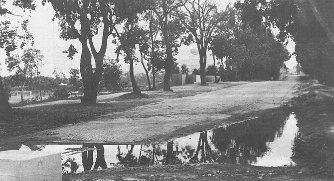
Old Route 101, Northview Drive — UCSD, north end
When UCSD first opened, the old Pacific Coast Highway, US 101, had not yet been replaced by the long-promised Interstate 5. Although 101 sliced the campus in two, this did not create much of a problem; in its early days, UCSD was mostly confined to the Revelle College area, west of the highway. When the I-5 freeway opened (1965), the university found new uses for the old 101. In the south-central part of the campus, it became the main entrance, Gilman Drive. In the center of UCSD, 101 was gradually turned into footpaths that now' run past Third College and Mandeville Auditorium. And at the northern end of campus, old 101 became Northview Drive, the northern entrance to UCSD.
Except for the block-long section near North Torrey Pines Road, Northview Drive hasn’t been a drive in years. A decade ago, the road was blocked with a guardhouse and concrete pillars. Today it’s a seldom-used, never-repaired walkway of crumbling asphalt. The photograph shows it as it looked after this January’s rains.
Old Torrey Pines Road/Camp Callan Roads — UCSD, near Revelle College
Torrey Pines Road used to run north-northeast through the present site of Revelle College, merging with Route 101 (now Gilman Drive) near the center of campus. In the early 1960s, city engineers closed off this old road and rerouted it around UCSD’s western perimeter, where it finally met the old 101 route (a.k.a. North Torrey Pines Road) at the extreme northern end of the campus.
All of this rerouting left a lot of “dead” roads in the southwest corner of campus. Besides the old Torrey Pines Road, the area was laced with narrow, curvy streets left over from a Second World War Army camp, Camp Callan.
Most of the Camp Callan roads (including the main one, Camino Callan) have been subsumed into parking lots, service roads, and walkways in the Revelle College area. As for the camp's buildings, they were mostly destroyed. But several of them were shoved together near the old Torrey Pines Road and used in the 1960s as an improvised student center.
There have been two new student centers since that original one, each grander than the last. But neither of them had the style or cachet of the first, an anarchist assemblage of barracks that now goes by the name of the Che Cafe.
In the picture we see a western elevation of the historic cafe, looking not unlike a Hollywood depiction of a Hitler headquarters in East Prussia.
The Great Crossroads: Route 101, Torrey Pines Road, La Jolla Shores Drive, Miramar Road UCSD
In 1959 a portion of the city’s Pueblo Lands was deeded to the state for the campus of UCSD. In the center of this parcel lay a five-way intersection. Three main roads met US 101: Miramar from the east, La Jolla Shores from the west, and Torrey Pines from the southwest. A short distance away, two smaller roads met Miramar: Sorrento Road and John Jay Hopkins Drive. In addition to all of these were the networks of streets and drives left over from two military camps, the Army’s Camp Callan and the Marine Corps’s Camp Matthews.
That this was a gem of a place in which to plonk down a new college may be seen from the fact that nearly all of the old Camp Matthews streets and buildings — even the Quonset huts — are still in daily use at UCSD. (The Marines left in ’64.) So are most of the roads, although many of them have been turned into walkways.
Such is the case today at the Great Crossroads. Bikes and pedestrians abound, but autos have no place to go except around a traffic island (left over from a fork in old Route 101) or into a parking lot. The old La Jolla Shores Drive here is nothing but a sidewalk; so are the former Miramar Road, Torrey Pines Road, and much of old 101.
Visitors and students alike complain of disorientation and a sense of anomie when they’re walking through the central campus. The “spaceship” central library was supposed to provide an orienting landmark, but it looks the same from all sides, so it just adds to the confusion.
Putting back the street signs for the former highways would go a long way to solving the UCSD direction problems. It would also help give one a sense of place. “C’mon, Feng-shui — let’s take a stroll up 101 and grab a slice of pizza!”
Miramar Road — UCSD
Thirty years ago, Miramar Road began at Route 101, headed northeast through the present site of the UCSD Price Center, then continued southeast and east along the northern border of Miramar Naval Air Station. Today its westernmost segments have been turned into: 1) Old Miramar Road and walkways on the UCSD campus; 2) a smidgen of Genesee Avenue; 3) Eastgate Mall, in the Golden Triangle region.
La Jolla Village Drive was created in the 1960s as a realignment of Miramar Road. The new road got a new name because at that time the original Miramar Road still existed in the UCSD area. Presumably the “La Jolla” nonsense was dreamt up to make the scrubby surroundings sound classier than they were.
If there’s any justice in San Diego, La Jolla Village Drive will someday drop its cumbersome and pretentious moniker. After all, it’s not in La Jolla, it doesn’t pass through any villages, and it’s very confusing for westbound motorists on Miramar Road to discover suddenly that the road they’re on has changed names.
Sorrento Road, UCSD to Sorrento Valley
Sorrento Road came into being around the Second World War, when it provided the only direct route from the two nearby military bases to the railroad depot in Sorrento Valley. A two-lane strip of asphalt laid at the bottom of a canyon, Sorrento Road was utilitarian rather than scenic. It closed for good in the mid-’60s, when the new Interstate 5 took the same canyon route between Genesee Avenue and Sorrento Valley.
Sorrento Road began on level ground at old Miramar Road (just south of the central library at UCSD — see photo) and headed northeast for about two miles, ending finally within 100 yards of the Santa Fe tracks at Sorrento Station.
The off-ramp from I-5 to Sorrento Valley Road follows the same canyon grade as the old Sorrento Road.
Smilax Road — Soledad Canyon, Sorrento Valley
According to the dictionary, smilax is “any of a number of related, usually prickly, woody vines, including the sarsaparilla.” Further research shows that Smilax is a trade name for sarsaparilla extract sold by the Bios corporation in Santa Barbara and that there is still extant an old road in Vista and San Marcos called Smilax Road.
There was also once a Smilax Road in Sorrento Valley, one in a series of short roads named for local flora. It paralleled the railroad tracks on their south side, but now it’s gone, the victim of freeway building in the 1960s. In its stead there’s another road, nearer the tracks, named Roselle Street.
Sorrento Road used to end near Smilax Road. You’ll find Smilax on maps made between 1945 and 1965.
Eidelweist Street — Sorrento Valley
Here we are at ground level, under the freeway span in the very crotch of the so-called 5-805 merge. Eidelweis Street, or Edelweiss Street, is the road that crosses the railroad tracks in Sorrento Valley. On the north side of the tracks it turns into Sorrento Valley Boulevard.
Eidelweis Street has appeared on local maps for 70 years. It’s still shown (Edelweiss spelling) in the Thomas Bros, guide. But there isn’t a single street sign for it. And passersby and businesspeople in the area say they’ve never heard of it. When asked, they’ll identify the street at the railroad crossing as Sorrento Valley Boulevard.
One stranger, in a nearby racquetball club, says he wishes there were an Eidelweis Street about. “Everything around here is Sorrento Valley this, Sorrento Valley that.”
Here's something you might be interested in.
Lost Roads of San Diego: California St., Douglas St., Sorrento Rd., Camp Callan AVe.
Dead ends, continued, part 2
Lost Roads of San Diego: California St., Douglas St., Sorrento Rd., Camp Callan AVe.
Dead ends, continued, part 2
Northview Drive, or Old Route 101, looking south
California Street — Downtown
In case you didn’t notice, we lost a historic downtown street just recently. Toward the end of 1992, most of the street signs for California Street came down. We shall not see them again. California Street, that slummy 19th-century drive on the west side of the railroad tracks, is gone for good, and the only reminders left us are stenciled notices from the Santa Fe Railway:
NOTICE
THIS IS NOT A PUBLIC HIGHWAY
IT IS THE PROPERTY OF THE
A.T.&S.F. RY. CO.
Actually, it’s not the Santa Fe Railway that abolished California Street. The trolley folks at MTDB are the culprits. In the process of improving the track bed, they had to obliterate the one narrow access road to the tracks that form the route for the northbound Old Town branch of the trolley. That branch reached Harborview (Cedar Street) last year and is scheduled to arrive at Washington Street in 1995.
California Street became the street-beside-the-railroad-tracks around 1885, just before the first Santa Fe depot opened. In those days, California Street ran right alongside, or very close to, the harbor. Now it’s a bit more inland, thanks to a century of landfills that have made possible such wonders as Pacific Highway, Harbor Drive, and the County Administration Building.
Hemmed in by the railroad right of way, California Street never got very wide or stylish. By the turn of the century it had acquired a low-rent, back-alley air and boasted mainly transients’ shacks and rooming houses. Even today many nearby blocks in the Harborview area offer a distinct whiff of early 20th-century squalor.
Contrast California’s story with that of Arctic Street, its parallel neighbor to the east. Arctic Street had a trolley line running down its middle and became a favored business address for auto dealers and furniture showrooms. Eventually Arctic became Kettner Boulevard. Kettner lost its trolley line, but it still bustles.
North of Vine Street, the tracks and California Street diverge. You can still find a couple of California Street signs in Middletown (near Cousins Warehouse) and in Old Town.
Douglas Street — Hillcrest/Mission Hills
The city’s biggest road project of the Second World War years was the so-called Douglas Street Connector, a stretch of highway that linked Mission Hills/Hillcrest with Pacific Highway and the Consolidated Vultee plants near Lindbergh Field. Today we know the Connector as that steep Washington Street grade running past the Gelato Vero coffeehouse on India Street.
The main casualty of the Douglas Street Connector was Douglas Street itself. It was an eight-block-long residential street running east-west between Albatross and Jackdaw, delightfully isolated by canyons at both ends. This isolation ended when Douglas Street was linked to University Avenue at its eastern end, to the Connector at its western.
“They filled in the canyon between Douglas Street and University and built a road across it,” recalls Eleanor Meadows, a San Diego native whose father built many of the Craftsman-style bungalows in the area. “They changed the name of the whole street to University, and now hardly anyone remembers about Douglas Street. It’s a shame.”
Which Douglas the street was named for is unclear. On maps printed before the 1920s, the name is “Douglass,” which seems clearly to refer to Frederick Douglass, the onetime slave and champion of Negro emancipation. Later maps spell it “Douglas,” suggesting statesman Stephen A. Douglas.
When the time came to name the Douglas Street Connector, no one thought to retain the name Douglas Street. In 1944 public works director Fred Rhodes and city planner Glenn Rick held a naming competition for the new artery. Some of the entries, as recorded in the San Diego Daily Journal: Hi-Five, Victory Way, Silvergate Freeway, Convair Way, Father Horton Road, Fifth Bond Drive, Boulevard of the Allies. A few spoilsports suggested it simply be named University Avenue or El Cajon Boulevard. In the end “Washington Freeway” won out, though the “Freeway” part never really caught on. And poor Douglas Street is now popularly known simply as “that narrow part of University Avenue that runs past Vons.”
Old Route 101, Northview Drive — UCSD, north end
When UCSD first opened, the old Pacific Coast Highway, US 101, had not yet been replaced by the long-promised Interstate 5. Although 101 sliced the campus in two, this did not create much of a problem; in its early days, UCSD was mostly confined to the Revelle College area, west of the highway. When the I-5 freeway opened (1965), the university found new uses for the old 101. In the south-central part of the campus, it became the main entrance, Gilman Drive. In the center of UCSD, 101 was gradually turned into footpaths that now' run past Third College and Mandeville Auditorium. And at the northern end of campus, old 101 became Northview Drive, the northern entrance to UCSD.
Except for the block-long section near North Torrey Pines Road, Northview Drive hasn’t been a drive in years. A decade ago, the road was blocked with a guardhouse and concrete pillars. Today it’s a seldom-used, never-repaired walkway of crumbling asphalt. The photograph shows it as it looked after this January’s rains.
Old Torrey Pines Road/Camp Callan Roads — UCSD, near Revelle College
Torrey Pines Road used to run north-northeast through the present site of Revelle College, merging with Route 101 (now Gilman Drive) near the center of campus. In the early 1960s, city engineers closed off this old road and rerouted it around UCSD’s western perimeter, where it finally met the old 101 route (a.k.a. North Torrey Pines Road) at the extreme northern end of the campus.
All of this rerouting left a lot of “dead” roads in the southwest corner of campus. Besides the old Torrey Pines Road, the area was laced with narrow, curvy streets left over from a Second World War Army camp, Camp Callan.
Most of the Camp Callan roads (including the main one, Camino Callan) have been subsumed into parking lots, service roads, and walkways in the Revelle College area. As for the camp's buildings, they were mostly destroyed. But several of them were shoved together near the old Torrey Pines Road and used in the 1960s as an improvised student center.
There have been two new student centers since that original one, each grander than the last. But neither of them had the style or cachet of the first, an anarchist assemblage of barracks that now goes by the name of the Che Cafe.
In the picture we see a western elevation of the historic cafe, looking not unlike a Hollywood depiction of a Hitler headquarters in East Prussia.
The Great Crossroads: Route 101, Torrey Pines Road, La Jolla Shores Drive, Miramar Road UCSD
In 1959 a portion of the city’s Pueblo Lands was deeded to the state for the campus of UCSD. In the center of this parcel lay a five-way intersection. Three main roads met US 101: Miramar from the east, La Jolla Shores from the west, and Torrey Pines from the southwest. A short distance away, two smaller roads met Miramar: Sorrento Road and John Jay Hopkins Drive. In addition to all of these were the networks of streets and drives left over from two military camps, the Army’s Camp Callan and the Marine Corps’s Camp Matthews.
That this was a gem of a place in which to plonk down a new college may be seen from the fact that nearly all of the old Camp Matthews streets and buildings — even the Quonset huts — are still in daily use at UCSD. (The Marines left in ’64.) So are most of the roads, although many of them have been turned into walkways.
Such is the case today at the Great Crossroads. Bikes and pedestrians abound, but autos have no place to go except around a traffic island (left over from a fork in old Route 101) or into a parking lot. The old La Jolla Shores Drive here is nothing but a sidewalk; so are the former Miramar Road, Torrey Pines Road, and much of old 101.
Visitors and students alike complain of disorientation and a sense of anomie when they’re walking through the central campus. The “spaceship” central library was supposed to provide an orienting landmark, but it looks the same from all sides, so it just adds to the confusion.
Putting back the street signs for the former highways would go a long way to solving the UCSD direction problems. It would also help give one a sense of place. “C’mon, Feng-shui — let’s take a stroll up 101 and grab a slice of pizza!”
Miramar Road — UCSD
Thirty years ago, Miramar Road began at Route 101, headed northeast through the present site of the UCSD Price Center, then continued southeast and east along the northern border of Miramar Naval Air Station. Today its westernmost segments have been turned into: 1) Old Miramar Road and walkways on the UCSD campus; 2) a smidgen of Genesee Avenue; 3) Eastgate Mall, in the Golden Triangle region.
La Jolla Village Drive was created in the 1960s as a realignment of Miramar Road. The new road got a new name because at that time the original Miramar Road still existed in the UCSD area. Presumably the “La Jolla” nonsense was dreamt up to make the scrubby surroundings sound classier than they were.
If there’s any justice in San Diego, La Jolla Village Drive will someday drop its cumbersome and pretentious moniker. After all, it’s not in La Jolla, it doesn’t pass through any villages, and it’s very confusing for westbound motorists on Miramar Road to discover suddenly that the road they’re on has changed names.
Sorrento Road, UCSD to Sorrento Valley
Sorrento Road came into being around the Second World War, when it provided the only direct route from the two nearby military bases to the railroad depot in Sorrento Valley. A two-lane strip of asphalt laid at the bottom of a canyon, Sorrento Road was utilitarian rather than scenic. It closed for good in the mid-’60s, when the new Interstate 5 took the same canyon route between Genesee Avenue and Sorrento Valley.
Sorrento Road began on level ground at old Miramar Road (just south of the central library at UCSD — see photo) and headed northeast for about two miles, ending finally within 100 yards of the Santa Fe tracks at Sorrento Station.
The off-ramp from I-5 to Sorrento Valley Road follows the same canyon grade as the old Sorrento Road.
Smilax Road — Soledad Canyon, Sorrento Valley
According to the dictionary, smilax is “any of a number of related, usually prickly, woody vines, including the sarsaparilla.” Further research shows that Smilax is a trade name for sarsaparilla extract sold by the Bios corporation in Santa Barbara and that there is still extant an old road in Vista and San Marcos called Smilax Road.
There was also once a Smilax Road in Sorrento Valley, one in a series of short roads named for local flora. It paralleled the railroad tracks on their south side, but now it’s gone, the victim of freeway building in the 1960s. In its stead there’s another road, nearer the tracks, named Roselle Street.
Sorrento Road used to end near Smilax Road. You’ll find Smilax on maps made between 1945 and 1965.
Eidelweist Street — Sorrento Valley
Here we are at ground level, under the freeway span in the very crotch of the so-called 5-805 merge. Eidelweis Street, or Edelweiss Street, is the road that crosses the railroad tracks in Sorrento Valley. On the north side of the tracks it turns into Sorrento Valley Boulevard.
Eidelweis Street has appeared on local maps for 70 years. It’s still shown (Edelweiss spelling) in the Thomas Bros, guide. But there isn’t a single street sign for it. And passersby and businesspeople in the area say they’ve never heard of it. When asked, they’ll identify the street at the railroad crossing as Sorrento Valley Boulevard.
One stranger, in a nearby racquetball club, says he wishes there were an Eidelweis Street about. “Everything around here is Sorrento Valley this, Sorrento Valley that.”
Part two of three. Part 1 | Part 3
Comments