

Here's something you might be interested in.
Ask a Hipster — Advice you didn't know you needed
Big Screen — Movie commentary
Blurt — Music's inside track
Booze News — San Diego spirits
Classical Music — Immortal beauty
Classifieds — Free and easy
Close to Home — What it’s like on the street where you live
Cover Stories — Front-page features
Drinks All Around — Bartenders' drink recipes
Excerpts — Literary and spiritual excerpts
Feast! — Food & drink reviews
Feature Stories — Local news & stories
Fishing Report — What’s getting hooked from ship and shore
From the Archives — Spotlight on the past
Golden Dreams — Talk of the town
The Gonzo Report — Making the musical scene, or at least reporting from it
Letters — Our inbox
Movies@Home — Local movie buffs share favorites
Movie Reviews — Our critics' picks and pans
Musician Interviews — Up close with local artists
Neighborhood News from Stringers — Hyperlocal news
News Ticker — News & politics
Obermeyer — San Diego politics illustrated
Outdoors — Weekly changes in flora and fauna
Overheard in San Diego — Eavesdropping illustrated
Poetry — The old and the new
Reader Travel — Travel section built by travelers
Reading — The hunt for intellectuals
Roam-O-Rama — SoCal's best hiking/biking trails
San Diego Beer — Inside San Diego suds
SD on the QT — Almost factual news
Sheep and Goats — Places of worship
Special Issues — The best of
Street Style — San Diego streets have style
Surf Diego — Real stories from those braving the waves
Theater — On stage in San Diego this week
Tin Fork — Silver spoon alternative
Under the Radar — Matt Potter's undercover work
Unforgettable — Long-ago San Diego
Unreal Estate — San Diego's priciest pads
Your Week — Daily event picks
Imperial Beach will try living levee
Opening up tidal flushing into pond 10A

Imperial Beach faces some of the region’s greatest risks.
Despite rising fears about rising sea levels, some bayside communities are trying to attract more shoreline development. Imperial Beach, which may face some of the region’s greatest risks from sea-level rise, is tackling coastal adaptation with projects like a 1.2-mile earthen levee on the Bayshore bikeway. It's an area where flooding is worsening even as biking is increasing.
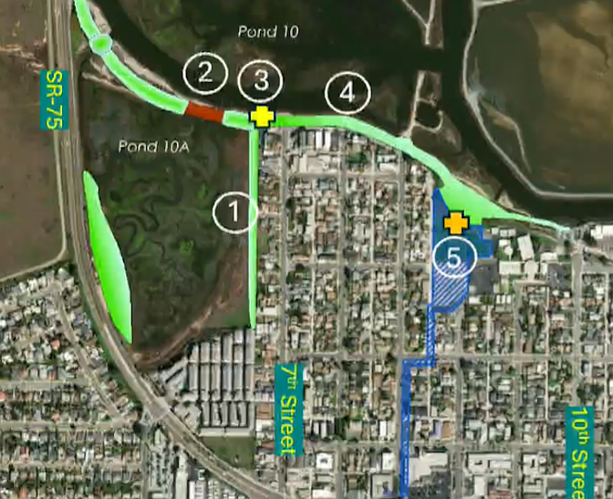
The levee will elevate the most flood-prone segment of the class 1 bikeway near 7th Street and Basswood Avenue.
On weekends, as many as 4000 users use the path, city officials say. But in winter, king tides and storm surges can leave the Imperial Beach segment of the 24-mile bikeway unusable, wreaking havoc on the bayside neighborhood it traverses, especially near 7th Street and Basswood Avenue. In El Nino years, the bike path overtops, flooding low-lying backyards on 7th Street. Those homes are in the FEMA flood zone, so the intent is to build protection for them.
“First and foremost, this is a flood control project,” Chris Helmer, the city’s director of environmental & natural resources, told the city council last week.

On weekends, as many as 4,000 users hit the path.
Every coastal city is required by the state to have a plan for sea rise of up to to 3.5 feet. The plan is expected to impact large portions of state route 75 and the surrounding neighborhood. And ever since implementing the general plan in 1994, it has been a city priority to create a coastal resilience corridor that addresses flood control, safety, habitat and recreation from Highway 75 to 10th Street. Now it’s more than just a plan.
Things got rolling in 2021 with a grant from the ocean protection council, followed by funding from the state. The long timeline for what seems like a simple city project reflects the fact that only part of the corridor falls under the city’s jurisdiction. It’s taken hundreds of plans, meetings with multiple agencies and pop-up events to get the Bayshore Bikeway Resiliency Project closer to the construction phase.
Some 1700 people provided feedback that helped shape the plans, and while public outreach is winding down, officials said there’s still room to tweak the design. Permitting is expected to begin near the end of next year.
The plan includes a living levee with a multi use path that runs beside the shoreline and the San Diego Bay National Wildlife Refuge, a new multi-use bikeway bridge and wetland habitat restoration, an access node for the bikeway at 7th Street, and a five-acre joint use bayside park. It will also update the stormwater system from its current capacity for a five-year storm — a storm that has a one in five chance of happening during any given year — to the standards of the 100-year storm, Helmer said.
The levee will elevate the most flood-prone segment of the class 1 bikeway near 7th Street and Basswood Avenue, and its ecotone slope will allow habitat transition over time.
A portion of the bikeway stretches between pond 10 and pond 10A — shallow basins once used for salt harvesting by the South Bay Salt Works system that were later converted back to tidal wetlands. “We’re opening up tidal flushing into pond 10A,” Helmer said. This will help control flooding while yielding ecological benefits by creating wetlands.
While community support for the project is strong, some want to see future bay access, especially at pond 10 and 10A, “for boats, people and any other means of water transport,” one comment read. The ponds however, are next to the San Diego Bay National Wildlife Refuge, managed by the U.S. Fish and Wildlife Service, and meant for restoration.
People also wanted more places to recreate besides the bike path, which led to the addition of a pocket park, as well as the large joint use park at Bayside elementary school. “We’re going to double the path of the bikeway,” he said, for safety, one of the biggest concerns of residents as e-bikes join the growing crowd.
Finally, he noted that pedestrians won’t be left out. “We’re going to enhance the separated walking path and make sure it stretches the entire length of that bikeway.”
Here's something you might be interested in.
Imperial Beach will try living levee
Opening up tidal flushing into pond 10A

Imperial Beach will try living levee
Opening up tidal flushing into pond 10A
Imperial Beach faces some of the region’s greatest risks.
Despite rising fears about rising sea levels, some bayside communities are trying to attract more shoreline development. Imperial Beach, which may face some of the region’s greatest risks from sea-level rise, is tackling coastal adaptation with projects like a 1.2-mile earthen levee on the Bayshore bikeway. It's an area where flooding is worsening even as biking is increasing.
The levee will elevate the most flood-prone segment of the class 1 bikeway near 7th Street and Basswood Avenue.
On weekends, as many as 4000 users use the path, city officials say. But in winter, king tides and storm surges can leave the Imperial Beach segment of the 24-mile bikeway unusable, wreaking havoc on the bayside neighborhood it traverses, especially near 7th Street and Basswood Avenue. In El Nino years, the bike path overtops, flooding low-lying backyards on 7th Street. Those homes are in the FEMA flood zone, so the intent is to build protection for them.
“First and foremost, this is a flood control project,” Chris Helmer, the city’s director of environmental & natural resources, told the city council last week.
On weekends, as many as 4,000 users hit the path.
Every coastal city is required by the state to have a plan for sea rise of up to to 3.5 feet. The plan is expected to impact large portions of state route 75 and the surrounding neighborhood. And ever since implementing the general plan in 1994, it has been a city priority to create a coastal resilience corridor that addresses flood control, safety, habitat and recreation from Highway 75 to 10th Street. Now it’s more than just a plan.
Things got rolling in 2021 with a grant from the ocean protection council, followed by funding from the state. The long timeline for what seems like a simple city project reflects the fact that only part of the corridor falls under the city’s jurisdiction. It’s taken hundreds of plans, meetings with multiple agencies and pop-up events to get the Bayshore Bikeway Resiliency Project closer to the construction phase.
Some 1700 people provided feedback that helped shape the plans, and while public outreach is winding down, officials said there’s still room to tweak the design. Permitting is expected to begin near the end of next year.
The plan includes a living levee with a multi use path that runs beside the shoreline and the San Diego Bay National Wildlife Refuge, a new multi-use bikeway bridge and wetland habitat restoration, an access node for the bikeway at 7th Street, and a five-acre joint use bayside park. It will also update the stormwater system from its current capacity for a five-year storm — a storm that has a one in five chance of happening during any given year — to the standards of the 100-year storm, Helmer said.
The levee will elevate the most flood-prone segment of the class 1 bikeway near 7th Street and Basswood Avenue, and its ecotone slope will allow habitat transition over time.
A portion of the bikeway stretches between pond 10 and pond 10A — shallow basins once used for salt harvesting by the South Bay Salt Works system that were later converted back to tidal wetlands. “We’re opening up tidal flushing into pond 10A,” Helmer said. This will help control flooding while yielding ecological benefits by creating wetlands.
While community support for the project is strong, some want to see future bay access, especially at pond 10 and 10A, “for boats, people and any other means of water transport,” one comment read. The ponds however, are next to the San Diego Bay National Wildlife Refuge, managed by the U.S. Fish and Wildlife Service, and meant for restoration.
People also wanted more places to recreate besides the bike path, which led to the addition of a pocket park, as well as the large joint use park at Bayside elementary school. “We’re going to double the path of the bikeway,” he said, for safety, one of the biggest concerns of residents as e-bikes join the growing crowd.
Finally, he noted that pedestrians won’t be left out. “We’re going to enhance the separated walking path and make sure it stretches the entire length of that bikeway.”
Comments