Here's something you might be interested in.
Ask a Hipster — Advice you didn't know you needed
Big Screen — Movie commentary
Blurt — Music's inside track
Booze News — San Diego spirits
Classical Music — Immortal beauty
Classifieds — Free and easy
Close to Home — What it’s like on the street where you live
Cover Stories — Front-page features
Drinks All Around — Bartenders' drink recipes
Excerpts — Literary and spiritual excerpts
Feast! — Food & drink reviews
Feature Stories — Local news & stories
Fishing Report — What’s getting hooked from ship and shore
From the Archives — Spotlight on the past
Golden Dreams — Talk of the town
The Gonzo Report — Making the musical scene, or at least reporting from it
Letters — Our inbox
Movies@Home — Local movie buffs share favorites
Movie Reviews — Our critics' picks and pans
Musician Interviews — Up close with local artists
Neighborhood News from Stringers — Hyperlocal news
News Ticker — News & politics
Obermeyer — San Diego politics illustrated
Outdoors — Weekly changes in flora and fauna
Overheard in San Diego — Eavesdropping illustrated
Poetry — The old and the new
Reader Travel — Travel section built by travelers
Reading — The hunt for intellectuals
Roam-O-Rama — SoCal's best hiking/biking trails
San Diego Beer — Inside San Diego suds
SD on the QT — Almost factual news
Sheep and Goats — Places of worship
Special Issues — The best of
Street Style — San Diego streets have style
Surf Diego — Real stories from those braving the waves
Theater — On stage in San Diego this week
Tin Fork — Silver spoon alternative
Under the Radar — Matt Potter's undercover work
Unforgettable — Long-ago San Diego
Unreal Estate — San Diego's priciest pads
Your Week — Daily event picks
Thrilling thermals lead to drinks in the desert
If you’re not going up, you’re going down
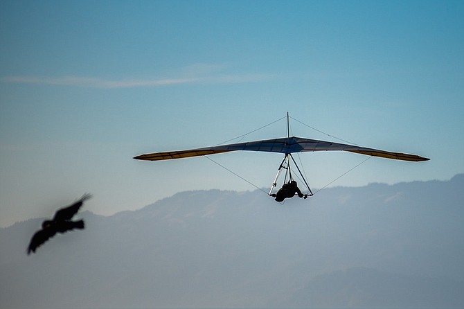
As a bonus, eagles, hawks, and other birds of prey will join you as you climb in a thermal.
As we set up our hang gliders on the launch at Mt Laguna, some 5400' above sea level, it felt like a normal summer day. We were hoping to fly far that day, and since you have no motor or power when hang gliding, the goal is to go up and get high, so you can have the longest flight possible. If you’re not going up, you’re going down, and your flight ends. It’s embarrassing to be the first pilot to land. To prolong our flying day, we are constantly looking for lift. The wind from the east was both ideal and necessary for our launch. When launching or landing a hang glider, you must have a breeze, or a wind, or a thermal blowing in your face. Wind from any other direction is dangerous — if not deadly.
I was lucky enough to be flying with some of San Diego’s best competitive hang glider pilots: Jersey Rossignol, Larry Costanza and Denny Mallet (from the OC) were flying together, all on the same radio frequency. There were many other great San Diego pilots flying that day as well, but connecting more than four people on the same radio frequency can be difficult. It’s very important to have clear communication with your fellow pilots, and especially your driver, who is following on the ground as you fly above.
We all launched fine, and immediately caught great thermals. Thermals are “bubbles” or “columns” of warm air that rise up from the earth; they may travel straight up or bend with the wind or landscape. Like waves in the ocean, no two thermals are alike; there are different shapes, sizes, strengths etc. A thermal can be the size of a football field, which means you have to make tight turns just to stay within its bounds, or as big as a city block — or even bigger. Thermals can also be so strong that you can’t descend or get out of them. They can even flip you upside down. But a thermal can also be gentle, so gentle that it takes only two fingers on the control bar to keep yourself in its embrace. As a bonus, eagles, hawks, and other birds of prey will join you as you climb in a thermal; I’ve had them position themselves right off the end of my glider’s wingtip, their wings motionless as they ride the rising air, their eyes meeting mine. I think they seem intrigued to find that something other than a bird is flying with them.
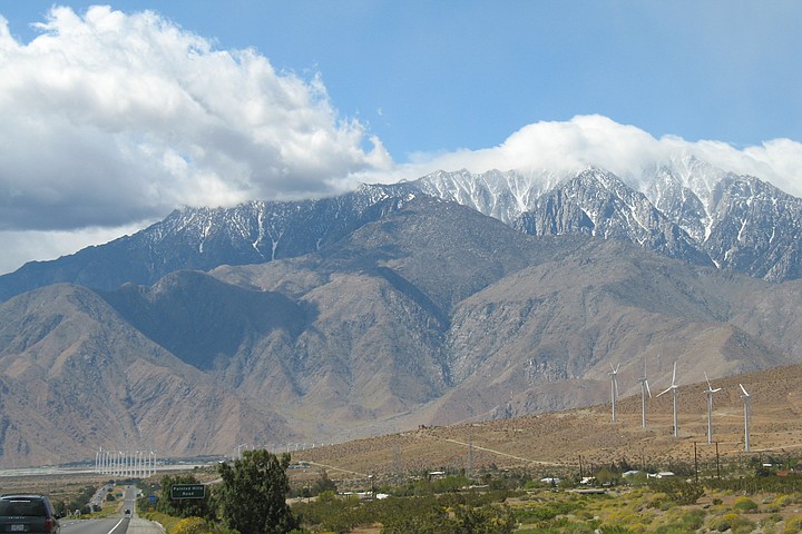
We could all see Mount San Jacinto in the distance, and it looked like we might be able to make it to Palm Springs.
After we reached 10,000 feet above sea level, we headed straight for Granite Mountain (5633 feet), which sits at the bottom of the Banner Grade, the southernmost point of the San Felipe valley. Geographical formations like mountains and hills can often be thermal generators, so you can seek them out and “leap frog” from lift to lift. The view from this height is amazing. On a clear day, you can see the Catalina Islands, Mexico, the mountains in San Bernardino, and more. The only hiccup was that my radio somehow became disconnected. I had no communication with my fellow pilots, or my driver. This was a problem I had to fix immediately, which gave rise to another problem: as I fumbled with my radio, I had to relinquish control of my glider. I wound up doing several spiral dives and lost at least a thousand feet of altitude. But I finally got it fixed.
The conditions really were ideal; even with my brief drop, I could tell this would be a great day to fly cross country. The lift was everywhere; we could get really high, and go really far. I climbed back up a thermal and rejoined my buddies. We flew over Lake Cuyamaca and continued north. We climbed along the west side of the San Felipe Valley, and made it to Hot Springs Mountain (6533’) by Warner Springs. I could see dust devils, like thin tornados of lift, ahead of us. Their lift was welcome, but they can be dangerous as well. We all climbed to about 10,000 feet, and continued to fly north — none too quickly, mind you. When you climb, you fly in circles like a raptor, within the boundaries of the thermal, letting it do the work. In a strong thermal, you can rise at a rate of 1000 feet per minute — or faster. Other thermals are more gentle; you’re still going up, but at a slower pace. Either way, lift is the key: “Never leave lift” is a mantra by which all hang glider pilots live.
After we got “stinking high” over Hot Springs Mountain, we headed further north, into territory I hadn’t seen before: huge boulders below, making for inhospitable territory. You must have a patch of smooth ground when landing; otherwise, you’ll be paying a visit to the hospital, or worse. Another concern: it was getting later in the day, and the lift was fading. Unless we found more lift, we would be landing soon, hopefully in a safe place. Happily, my buddies — who were all managing to stay higher than I was — were among the best pilots in the world, so I just followed their instructions from above. I got the message: “Pick a nice landing.” We could all see Mount San Jacinto (10,834) in the distance, and it looked like we might be able to make it to Palm Springs.
We all carried miniature smoke bombs attached to our control bars. Their only function was to tell us which direction the wind was blowing as we approached our landing. Again: you must be headed into the wind while landing, or there will be consequences. I was no more than a thousand feet over Cathedral City when I spotted a weathered golf course (certainly not PGA quality) that looked ideal for landing. I threw my smoke bomb. It landed on somebody’s tennis court. I’m sorry about that, Mr. or Mrs. Homeowner. I’m sure it left a nasty stain.
As I descended, I picked out a decent fairway — kind of yellow, maybe a par five — that looked perfect. Perfect for the wind, anyway; it’s always dicey landing in places like this, because technically, we’re trespassing. But I was low and had no choice. The sun was setting as I came in for an easy landing after the longest flight of my life: 60 miles point to point. Immediately, a golf cart pulled up to me. The driver was a sixty-ish woman with a cocktail in her hand.
“Where did you come from?”
“Mount Laguna.”
“Where’s that?”
“It’s outside of San Diego.”
“Wow. Do you want a drink?”
“Well yes I do, thank you, and I have friends coming behind me.”
After they landed, we folded up our gliders and drank beers and cocktails with our new friends. I thank my old friends — Jersey, Larry, Denny, and our driver Amy — for giving me the opportunity of a lifetime.
Here's something you might be interested in.
Thrilling thermals lead to drinks in the desert
If you’re not going up, you’re going down
Thrilling thermals lead to drinks in the desert
If you’re not going up, you’re going down
As a bonus, eagles, hawks, and other birds of prey will join you as you climb in a thermal.
As we set up our hang gliders on the launch at Mt Laguna, some 5400' above sea level, it felt like a normal summer day. We were hoping to fly far that day, and since you have no motor or power when hang gliding, the goal is to go up and get high, so you can have the longest flight possible. If you’re not going up, you’re going down, and your flight ends. It’s embarrassing to be the first pilot to land. To prolong our flying day, we are constantly looking for lift. The wind from the east was both ideal and necessary for our launch. When launching or landing a hang glider, you must have a breeze, or a wind, or a thermal blowing in your face. Wind from any other direction is dangerous — if not deadly.
I was lucky enough to be flying with some of San Diego’s best competitive hang glider pilots: Jersey Rossignol, Larry Costanza and Denny Mallet (from the OC) were flying together, all on the same radio frequency. There were many other great San Diego pilots flying that day as well, but connecting more than four people on the same radio frequency can be difficult. It’s very important to have clear communication with your fellow pilots, and especially your driver, who is following on the ground as you fly above.
We all launched fine, and immediately caught great thermals. Thermals are “bubbles” or “columns” of warm air that rise up from the earth; they may travel straight up or bend with the wind or landscape. Like waves in the ocean, no two thermals are alike; there are different shapes, sizes, strengths etc. A thermal can be the size of a football field, which means you have to make tight turns just to stay within its bounds, or as big as a city block — or even bigger. Thermals can also be so strong that you can’t descend or get out of them. They can even flip you upside down. But a thermal can also be gentle, so gentle that it takes only two fingers on the control bar to keep yourself in its embrace. As a bonus, eagles, hawks, and other birds of prey will join you as you climb in a thermal; I’ve had them position themselves right off the end of my glider’s wingtip, their wings motionless as they ride the rising air, their eyes meeting mine. I think they seem intrigued to find that something other than a bird is flying with them.
We could all see Mount San Jacinto in the distance, and it looked like we might be able to make it to Palm Springs.
After we reached 10,000 feet above sea level, we headed straight for Granite Mountain (5633 feet), which sits at the bottom of the Banner Grade, the southernmost point of the San Felipe valley. Geographical formations like mountains and hills can often be thermal generators, so you can seek them out and “leap frog” from lift to lift. The view from this height is amazing. On a clear day, you can see the Catalina Islands, Mexico, the mountains in San Bernardino, and more. The only hiccup was that my radio somehow became disconnected. I had no communication with my fellow pilots, or my driver. This was a problem I had to fix immediately, which gave rise to another problem: as I fumbled with my radio, I had to relinquish control of my glider. I wound up doing several spiral dives and lost at least a thousand feet of altitude. But I finally got it fixed.
The conditions really were ideal; even with my brief drop, I could tell this would be a great day to fly cross country. The lift was everywhere; we could get really high, and go really far. I climbed back up a thermal and rejoined my buddies. We flew over Lake Cuyamaca and continued north. We climbed along the west side of the San Felipe Valley, and made it to Hot Springs Mountain (6533’) by Warner Springs. I could see dust devils, like thin tornados of lift, ahead of us. Their lift was welcome, but they can be dangerous as well. We all climbed to about 10,000 feet, and continued to fly north — none too quickly, mind you. When you climb, you fly in circles like a raptor, within the boundaries of the thermal, letting it do the work. In a strong thermal, you can rise at a rate of 1000 feet per minute — or faster. Other thermals are more gentle; you’re still going up, but at a slower pace. Either way, lift is the key: “Never leave lift” is a mantra by which all hang glider pilots live.
After we got “stinking high” over Hot Springs Mountain, we headed further north, into territory I hadn’t seen before: huge boulders below, making for inhospitable territory. You must have a patch of smooth ground when landing; otherwise, you’ll be paying a visit to the hospital, or worse. Another concern: it was getting later in the day, and the lift was fading. Unless we found more lift, we would be landing soon, hopefully in a safe place. Happily, my buddies — who were all managing to stay higher than I was — were among the best pilots in the world, so I just followed their instructions from above. I got the message: “Pick a nice landing.” We could all see Mount San Jacinto (10,834) in the distance, and it looked like we might be able to make it to Palm Springs.
We all carried miniature smoke bombs attached to our control bars. Their only function was to tell us which direction the wind was blowing as we approached our landing. Again: you must be headed into the wind while landing, or there will be consequences. I was no more than a thousand feet over Cathedral City when I spotted a weathered golf course (certainly not PGA quality) that looked ideal for landing. I threw my smoke bomb. It landed on somebody’s tennis court. I’m sorry about that, Mr. or Mrs. Homeowner. I’m sure it left a nasty stain.
As I descended, I picked out a decent fairway — kind of yellow, maybe a par five — that looked perfect. Perfect for the wind, anyway; it’s always dicey landing in places like this, because technically, we’re trespassing. But I was low and had no choice. The sun was setting as I came in for an easy landing after the longest flight of my life: 60 miles point to point. Immediately, a golf cart pulled up to me. The driver was a sixty-ish woman with a cocktail in her hand.
“Where did you come from?”
“Mount Laguna.”
“Where’s that?”
“It’s outside of San Diego.”
“Wow. Do you want a drink?”
“Well yes I do, thank you, and I have friends coming behind me.”
After they landed, we folded up our gliders and drank beers and cocktails with our new friends. I thank my old friends — Jersey, Larry, Denny, and our driver Amy — for giving me the opportunity of a lifetime.
Comments