Here's something you might be interested in.
Ask a Hipster — Advice you didn't know you needed
Big Screen — Movie commentary
Blurt — Music's inside track
Booze News — San Diego spirits
Classical Music — Immortal beauty
Classifieds — Free and easy
Close to Home — What it’s like on the street where you live
Cover Stories — Front-page features
Drinks All Around — Bartenders' drink recipes
Excerpts — Literary and spiritual excerpts
Feast! — Food & drink reviews
Feature Stories — Local news & stories
Fishing Report — What’s getting hooked from ship and shore
From the Archives — Spotlight on the past
Golden Dreams — Talk of the town
The Gonzo Report — Making the musical scene, or at least reporting from it
Letters — Our inbox
Movies@Home — Local movie buffs share favorites
Movie Reviews — Our critics' picks and pans
Musician Interviews — Up close with local artists
Neighborhood News from Stringers — Hyperlocal news
News Ticker — News & politics
Obermeyer — San Diego politics illustrated
Outdoors — Weekly changes in flora and fauna
Overheard in San Diego — Eavesdropping illustrated
Poetry — The old and the new
Reader Travel — Travel section built by travelers
Reading — The hunt for intellectuals
Roam-O-Rama — SoCal's best hiking/biking trails
San Diego Beer — Inside San Diego suds
SD on the QT — Almost factual news
Sheep and Goats — Places of worship
Special Issues — The best of
Street Style — San Diego streets have style
Surf Diego — Real stories from those braving the waves
Theater — On stage in San Diego this week
Tin Fork — Silver spoon alternative
Under the Radar — Matt Potter's undercover work
Unforgettable — Long-ago San Diego
Unreal Estate — San Diego's priciest pads
Your Week — Daily event picks
4000 feet above Borrego's Palm Canyon
The trail down is hard to trace
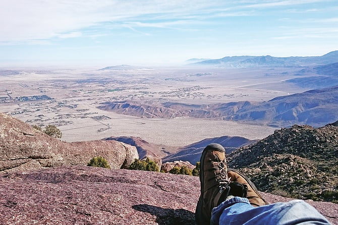
So worth it.
- San Ysidro Mountain
- Located in Borrego Palm Canyon, San Ysidro Mountain is a challenging hike and long pants and trekking poles are recommended. With a length of 8.1 miles and an elevation gain of 4000+ feet, the hike will take most people between 6 and 7 hours to reach the summit and descend. Dogs are not allowed.
- Distance from downtown San Diego: 86 miles
- Hike length: 8 miles • Difficulty: Hard • Season: October - March
“I’m going to climb up the side of a mountain,” I told the woman working the kiosk at the Borrego Palm Canyon Campground.
“Where?” she asked.
“There,” I said, smiling toothily and pointing at San Ysidro mountain, its peak towering 4000 feet above us.
“Oh.”
It wasn’t the response I was hoping for. Big solo hikes always get me anxious beforehand. I could have used an encouraging “Really? That’s awesome!” But there’s only so much encouragement you can hope for when you’re traveling alone.
I parked my car and packed my backpack — three liters of water, a variety of snacks, and warm clothes — before heading to the trailhead at the Panorama Overlook Trail. It’s about a 300-foot climb from the desert floor to reach the overlook, followed by a distinct ridgeline that takes you up to the mountain. As I climbed, the escarpment to my right sloped down, hinting at the precipitous canyons and palm oases below me. I had brought trekking poles to help keep my footing, but the trail was wide enough that I never felt concerned about tumbling down the sharp scree on either side.
I noticed the tiny granite rocks dotting the trail, like freckles on the mountain’s face. But it wasn’t long before the rocks I spotted were proper boulders, the grown-up versions of what I had seen before. They made for much needed rest areas where I could stop for a few mintues to catch my breath, dry my socks, and soak in the desert vista. By the time I was halfway up the trail, I could glimpse the Salton Sea to the east, mostly hidden by haze. The view of Anza Borrego, however, was excellent, even from just a couple thousand feet up.
Eventually, I made it to a plateau, where I saw signs that other wanderers had set up camp here in the past. I was sad that I hadn’t brought my own overnight gear, but consoled by the high desert wind in my hair and the view. The intersecting roads that connected Borrego Springs looked like ancient geoglyphs. I felt like an Olympic god, staring down on the first civilization. To the south, I could see Whale Peak, Granite Mountain, and Cuyamaca Peak, bare and uninviting.

The blue line is the way up, the red line was the wrong turn, aka the “difficult way down.”
I began my descent sometime later. There was a feeling of horror as I did, like I was teetering at the edge of the world and would fall head over heels if I wasn’t wary. One ill-fated breath of wind might send me tumbling toward my demise – which, in my paranoia, I knew would be caused by a sharp yucca leaf waiting to impale me. I shook the thought from my mind, checked my laces, tightened my trekking poles, and tried to find comfort in my years of experience as I cautiously found my footing down the mountain. But while the trail up was distinct and easy to follow, like sauntering along the yellow brick road to Oz, the trail down proved more difficult to trace. Instead of simply retracing my steps, I veered too far south and wound up off the ridgeline and sidling along a slope between two ridges. By the time I realized my mistake, I was staring at a thousand-foot drop. Had I been on some snow-capped peak, I could have carefully glissaded down the side of the mountain. But this was the desert: I could feel the warm sun against my neck, and I could see razor-sharp yucca leaves covering the slope. Retracing my steps would keep me on the mountain longer than I was prepared to stay. I told myself I could do this and pressed on, walking along the side of the mountain, clinging to boulders and creosote branches as my boots sank into untrodden dirt. The terrain was rugged and the sharp rocks and plants made it a painful affair. Every so often, I had to wedge myself between a pair of boulders so that I could safely shake the coarse grit from my boots; and a couple of times, I had to get on my knees to squeeze through dense brush. An ugly moment, one that besmirched everything that I stand for as a hiker. But sometimes we bite off more than we can chew, and must do what we can to get by.
After about an hour, I wormed my way over to one of the other ridges that fed into the mountains. Although I was tired and sore, my heart felt lighter as I reached the well-beaten path. And when my boots finally touched the desert floor, I very nearly kissed the earth.
By the time I made it to my car, about six hours after starting out, I was shiny with sweat and matted with dirt. I passed by the kiosk on my way out and waved to the woman who had given me a day pass. Her amazed expression would have been the best part of the ordeal if it weren’t for the views from the top. But as I drove out of the desert, the hike felt less and less like a victory, and I decided to reflect on the lesson that I had learned: always stay on the trail.
Here's something you might be interested in.
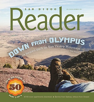
4000 feet above Borrego's Palm Canyon
The trail down is hard to trace
4000 feet above Borrego's Palm Canyon
The trail down is hard to trace
So worth it.
- San Ysidro Mountain
- Located in Borrego Palm Canyon, San Ysidro Mountain is a challenging hike and long pants and trekking poles are recommended. With a length of 8.1 miles and an elevation gain of 4000+ feet, the hike will take most people between 6 and 7 hours to reach the summit and descend. Dogs are not allowed.
- Distance from downtown San Diego: 86 miles
- Hike length: 8 miles • Difficulty: Hard • Season: October - March
“I’m going to climb up the side of a mountain,” I told the woman working the kiosk at the Borrego Palm Canyon Campground.
“Where?” she asked.
“There,” I said, smiling toothily and pointing at San Ysidro mountain, its peak towering 4000 feet above us.
“Oh.”
It wasn’t the response I was hoping for. Big solo hikes always get me anxious beforehand. I could have used an encouraging “Really? That’s awesome!” But there’s only so much encouragement you can hope for when you’re traveling alone.
I parked my car and packed my backpack — three liters of water, a variety of snacks, and warm clothes — before heading to the trailhead at the Panorama Overlook Trail. It’s about a 300-foot climb from the desert floor to reach the overlook, followed by a distinct ridgeline that takes you up to the mountain. As I climbed, the escarpment to my right sloped down, hinting at the precipitous canyons and palm oases below me. I had brought trekking poles to help keep my footing, but the trail was wide enough that I never felt concerned about tumbling down the sharp scree on either side.
I noticed the tiny granite rocks dotting the trail, like freckles on the mountain’s face. But it wasn’t long before the rocks I spotted were proper boulders, the grown-up versions of what I had seen before. They made for much needed rest areas where I could stop for a few mintues to catch my breath, dry my socks, and soak in the desert vista. By the time I was halfway up the trail, I could glimpse the Salton Sea to the east, mostly hidden by haze. The view of Anza Borrego, however, was excellent, even from just a couple thousand feet up.
Eventually, I made it to a plateau, where I saw signs that other wanderers had set up camp here in the past. I was sad that I hadn’t brought my own overnight gear, but consoled by the high desert wind in my hair and the view. The intersecting roads that connected Borrego Springs looked like ancient geoglyphs. I felt like an Olympic god, staring down on the first civilization. To the south, I could see Whale Peak, Granite Mountain, and Cuyamaca Peak, bare and uninviting.
The blue line is the way up, the red line was the wrong turn, aka the “difficult way down.”
I began my descent sometime later. There was a feeling of horror as I did, like I was teetering at the edge of the world and would fall head over heels if I wasn’t wary. One ill-fated breath of wind might send me tumbling toward my demise – which, in my paranoia, I knew would be caused by a sharp yucca leaf waiting to impale me. I shook the thought from my mind, checked my laces, tightened my trekking poles, and tried to find comfort in my years of experience as I cautiously found my footing down the mountain. But while the trail up was distinct and easy to follow, like sauntering along the yellow brick road to Oz, the trail down proved more difficult to trace. Instead of simply retracing my steps, I veered too far south and wound up off the ridgeline and sidling along a slope between two ridges. By the time I realized my mistake, I was staring at a thousand-foot drop. Had I been on some snow-capped peak, I could have carefully glissaded down the side of the mountain. But this was the desert: I could feel the warm sun against my neck, and I could see razor-sharp yucca leaves covering the slope. Retracing my steps would keep me on the mountain longer than I was prepared to stay. I told myself I could do this and pressed on, walking along the side of the mountain, clinging to boulders and creosote branches as my boots sank into untrodden dirt. The terrain was rugged and the sharp rocks and plants made it a painful affair. Every so often, I had to wedge myself between a pair of boulders so that I could safely shake the coarse grit from my boots; and a couple of times, I had to get on my knees to squeeze through dense brush. An ugly moment, one that besmirched everything that I stand for as a hiker. But sometimes we bite off more than we can chew, and must do what we can to get by.
After about an hour, I wormed my way over to one of the other ridges that fed into the mountains. Although I was tired and sore, my heart felt lighter as I reached the well-beaten path. And when my boots finally touched the desert floor, I very nearly kissed the earth.
By the time I made it to my car, about six hours after starting out, I was shiny with sweat and matted with dirt. I passed by the kiosk on my way out and waved to the woman who had given me a day pass. Her amazed expression would have been the best part of the ordeal if it weren’t for the views from the top. But as I drove out of the desert, the hike felt less and less like a victory, and I decided to reflect on the lesson that I had learned: always stay on the trail.