Here's something you might be interested in.
Ask a Hipster — Advice you didn't know you needed
Big Screen — Movie commentary
Blurt — Music's inside track
Booze News — San Diego spirits
Classical Music — Immortal beauty
Classifieds — Free and easy
Close to Home — What it’s like on the street where you live
Cover Stories — Front-page features
Drinks All Around — Bartenders' drink recipes
Excerpts — Literary and spiritual excerpts
Feast! — Food & drink reviews
Feature Stories — Local news & stories
Fishing Report — What’s getting hooked from ship and shore
From the Archives — Spotlight on the past
Golden Dreams — Talk of the town
The Gonzo Report — Making the musical scene, or at least reporting from it
Letters — Our inbox
Movies@Home — Local movie buffs share favorites
Movie Reviews — Our critics' picks and pans
Musician Interviews — Up close with local artists
Neighborhood News from Stringers — Hyperlocal news
News Ticker — News & politics
Obermeyer — San Diego politics illustrated
Outdoors — Weekly changes in flora and fauna
Overheard in San Diego — Eavesdropping illustrated
Poetry — The old and the new
Reader Travel — Travel section built by travelers
Reading — The hunt for intellectuals
Roam-O-Rama — SoCal's best hiking/biking trails
San Diego Beer — Inside San Diego suds
SD on the QT — Almost factual news
Sheep and Goats — Places of worship
Special Issues — The best of
Street Style — San Diego streets have style
Surf Diego — Real stories from those braving the waves
Theater — On stage in San Diego this week
Tin Fork — Silver spoon alternative
Under the Radar — Matt Potter's undercover work
Unforgettable — Long-ago San Diego
Unreal Estate — San Diego's priciest pads
Your Week — Daily event picks
Garnet Peak is a gem that lives up to its name
This time of year fall colors are on full display
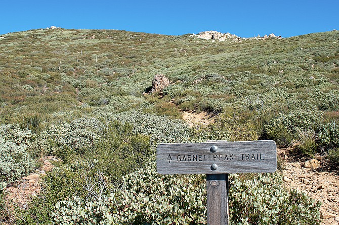
Garnet Peak sign marking the ascent.
- Garnet Peak from Sunrise Highway S1
- Located north of Mount Laguna, Garnet Peak is a fairly easy hike. With a length of 2.3 miles and an elevation gain of around 500 feet, the hike will take most people an hour and a half to reach the summit and descend. Dogs are allowed and a Cleveland National Forest daily pass is required for parking.
- Distance from downtown San Diego: 60 miles
- Hike length: 2.3 miles • Difficulty: Fairly Easy • Season: Year-round
“Are you going to write about this hike?” My buddy Joey asked as we stood atop Garnet Peak.
“I dunno,” I responded. “It’s not a very hard hike and it’s got like a thousand reviews on AllTrails. And it’s probably one of the most popular trails near Mount Laguna.”
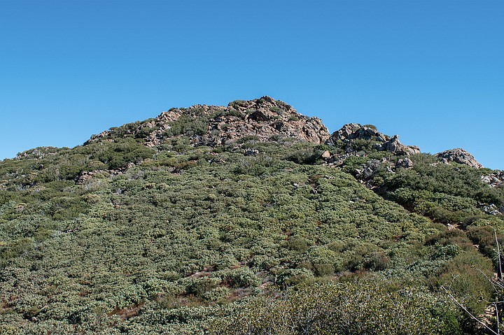
Garnet Peak squatting over a field of manzanita.
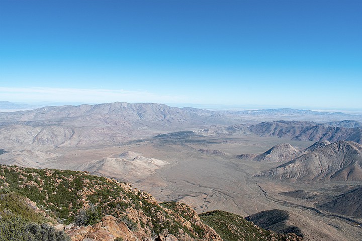
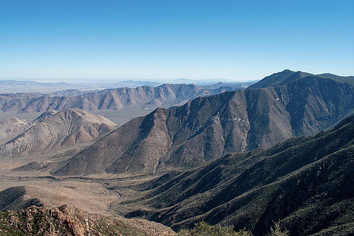
Joey nodded but didn’t respond. Instead, we both fell silent as we surveyed the horizon. The wind was blowing from the east, beating against the side of the mountain. I was standing on a steep rocky precipice listening to the wind howl as it climbed up the mountains’ roots that grew out of the desert valley below. The wind was icy, but not fierce enough to prevent me from taking in my surroundings. I had at my command a wide view and could see San Gorgonio and San Jacinto nearby to the north, as well as several familiar desert peaks, including Toro Peak, Villager’s Peak, Whale Peak, Granite Mountain, and San Ysidro Mountain. To the east, I could see the Salton Sea about 40 miles distant and 6,000’ below me. It was partially hidden behind a layer of chalky haze.
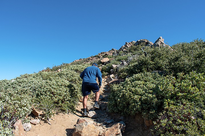
Joey begins the final ascent which ends with a rock scramble.
With a terrible shriek a gust came over the mountain and I heard a deep echoing boom below me. Carefully, I took a step closer to the edge. Then another. The wind clawed at my boots and I leaned slightly forward to look off the side of the mountain. As I did, the slope seemed to slip away into cracks and gullies and the longer I stared the more I felt a chilling sensation settle in my bones. I tried to shake the feeling by turning southeast to face the sun, but the Laguna Mountain range no longer stood still, instead it seemed to swell and I had the bizarre impression that I was standing on the crest of a massive tsunami just before the wave broke.
Looking east with Whale Peak in the distance.
“Do you ever get the urge to jump?” Joey asked. His eyes widened as he cautiously poked his head over the ledge to peer off the side of the peak. It was a very long way down.
“Mhm,” I hummed while stepping away from the ledge. “The French call it l’appel du vide or call of the void. It’s their name for that tiny scratch in the back of your skull, urging you to plunge into the abyss while standing on something high up.”
“Damn,” mused Joey.
“Nah, it’s normal. I read that it’s your brain realizing you could die, but then deciding not to. It’s actually a good thing because your brain is making a decision to stay alive. But don’t quote me on that.”
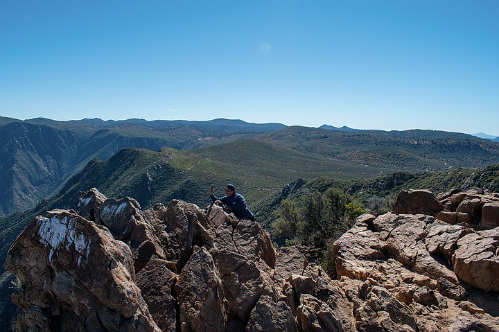
Joey records the view for Instagram clout.
Despite the terrifying drop beneath him, Joey took out his phone and started filming. As he moved the camera around, he eventually settled on a motion that he liked and spent a few minutes rehearsing it for Instagram. I decided to follow suit and snapped a few photos myself. Alone together, we both fidgeted with our devices as a few scattered clouds quietly drifted by high above. They were thin and wispy, as if they had been gently brushed across the sky.
Looking southeast towards the Laguna Mountain Range.
It had taken us a little under a half hour to reach the top. The trail was easy to follow and we walked at a conversational pace for most of it. Because the hike was so casual, I wore a long sleeve shirt and a cotton sweater instead of my usual sweat clothes. This kept me warm for the first half of the path as we meandered past various chaparral and a peculiar ash-colored shrub before ducking under a row of pine trees. But I did break out in a light sweat as we started along the last half of the trail, where the path turned upward and intersected with the Pacific Crest Trail.
To my surprise, the well-known trail was well-trodden. Backpacking along it was a 30-something couple traveling south. They were from the U.K. and had started months earlier at the Canadian border and were now close to wrapping up their adventure at the southern terminus in Campo. Both hikers looked like they had been on the trail for some time as the man had a bushy mountain beard while the woman had a sun-kissed glow unique to surfers and thru-hikers. Both looked agile and sinewy and were friendly enough to wave goodbye as our paths diverged.
As they disappeared from sight, Joey and I started our short ascent. The trail was composed of loose rocks that gave way to larger stepping stones near the top, with an easy scramble at the end. Between these last two sections, there was a nice moment where the trail cut through a field of manzanitas, atop which squatted the stony peak. From this vantage, it was hard to believe that the backside of the mountain fell away into the desert abyss.
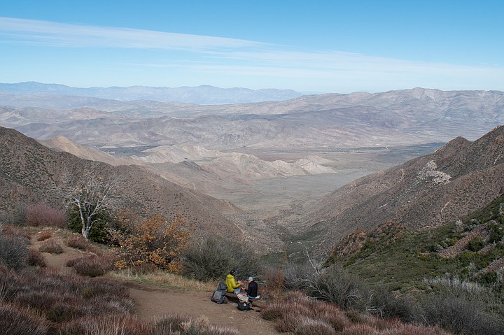
Bumped back into the PCT couple as they sit for lunch.
Technically this hike is listed as moderate difficult in Jerry Schad’s Afoot & Afield San Diego County and on AllTrails, but this time of year it was an easygoing affair. The hardest part was finding the trailhead as Google Maps took us to the wrong spot and we had to backtrack south a thousand feet. The parking area was little more than a dirt shoulder on the side of S1 where six competent drivers could park; though I often wonder if San Diego has that many. There were no other cars when we arrived late in the morning, but there was a shiny Mini Cooper crouched in the brush on the way out. On the off chance that there is no parking at the Garnet Peak Trailhead, you can park at the Penny Pines Trailhead half a mile south. I recommend starting here for three reasons: there’s more parking; the hike is longer, spanning about 4 miles instead of a measly 2.3 miles; and most of the trail is on the PCT, meaning you can humblebrag to folks that you’ve hiked the PCT both north and south – just be sure to omit that it was only 1/2600 of the entire trail.
Garnet Peak is a gem that lives up to its name. It’s a shorter hike than most peaks with a far richer and more unique view that puts other local vistas to shame. Despite the blustery wind at the top, this is a pleasant time of year to go as the fall colors are on full display. Driving up S1, the black oak trees were a vibrant yellow and if you have any East Coast in-laws coming to town for the holidays, this might be a good way to prove to them that autumn happens here too.
Here's something you might be interested in.
Garnet Peak is a gem that lives up to its name
This time of year fall colors are on full display
Garnet Peak is a gem that lives up to its name
This time of year fall colors are on full display
Garnet Peak sign marking the ascent.
- Garnet Peak from Sunrise Highway S1
- Located north of Mount Laguna, Garnet Peak is a fairly easy hike. With a length of 2.3 miles and an elevation gain of around 500 feet, the hike will take most people an hour and a half to reach the summit and descend. Dogs are allowed and a Cleveland National Forest daily pass is required for parking.
- Distance from downtown San Diego: 60 miles
- Hike length: 2.3 miles • Difficulty: Fairly Easy • Season: Year-round
“Are you going to write about this hike?” My buddy Joey asked as we stood atop Garnet Peak.
“I dunno,” I responded. “It’s not a very hard hike and it’s got like a thousand reviews on AllTrails. And it’s probably one of the most popular trails near Mount Laguna.”
Garnet Peak squatting over a field of manzanita.
Joey nodded but didn’t respond. Instead, we both fell silent as we surveyed the horizon. The wind was blowing from the east, beating against the side of the mountain. I was standing on a steep rocky precipice listening to the wind howl as it climbed up the mountains’ roots that grew out of the desert valley below. The wind was icy, but not fierce enough to prevent me from taking in my surroundings. I had at my command a wide view and could see San Gorgonio and San Jacinto nearby to the north, as well as several familiar desert peaks, including Toro Peak, Villager’s Peak, Whale Peak, Granite Mountain, and San Ysidro Mountain. To the east, I could see the Salton Sea about 40 miles distant and 6,000’ below me. It was partially hidden behind a layer of chalky haze.
Joey begins the final ascent which ends with a rock scramble.
With a terrible shriek a gust came over the mountain and I heard a deep echoing boom below me. Carefully, I took a step closer to the edge. Then another. The wind clawed at my boots and I leaned slightly forward to look off the side of the mountain. As I did, the slope seemed to slip away into cracks and gullies and the longer I stared the more I felt a chilling sensation settle in my bones. I tried to shake the feeling by turning southeast to face the sun, but the Laguna Mountain range no longer stood still, instead it seemed to swell and I had the bizarre impression that I was standing on the crest of a massive tsunami just before the wave broke.
Looking east with Whale Peak in the distance.
“Do you ever get the urge to jump?” Joey asked. His eyes widened as he cautiously poked his head over the ledge to peer off the side of the peak. It was a very long way down.
“Mhm,” I hummed while stepping away from the ledge. “The French call it l’appel du vide or call of the void. It’s their name for that tiny scratch in the back of your skull, urging you to plunge into the abyss while standing on something high up.”
“Damn,” mused Joey.
“Nah, it’s normal. I read that it’s your brain realizing you could die, but then deciding not to. It’s actually a good thing because your brain is making a decision to stay alive. But don’t quote me on that.”
Joey records the view for Instagram clout.
Despite the terrifying drop beneath him, Joey took out his phone and started filming. As he moved the camera around, he eventually settled on a motion that he liked and spent a few minutes rehearsing it for Instagram. I decided to follow suit and snapped a few photos myself. Alone together, we both fidgeted with our devices as a few scattered clouds quietly drifted by high above. They were thin and wispy, as if they had been gently brushed across the sky.
Looking southeast towards the Laguna Mountain Range.
It had taken us a little under a half hour to reach the top. The trail was easy to follow and we walked at a conversational pace for most of it. Because the hike was so casual, I wore a long sleeve shirt and a cotton sweater instead of my usual sweat clothes. This kept me warm for the first half of the path as we meandered past various chaparral and a peculiar ash-colored shrub before ducking under a row of pine trees. But I did break out in a light sweat as we started along the last half of the trail, where the path turned upward and intersected with the Pacific Crest Trail.
To my surprise, the well-known trail was well-trodden. Backpacking along it was a 30-something couple traveling south. They were from the U.K. and had started months earlier at the Canadian border and were now close to wrapping up their adventure at the southern terminus in Campo. Both hikers looked like they had been on the trail for some time as the man had a bushy mountain beard while the woman had a sun-kissed glow unique to surfers and thru-hikers. Both looked agile and sinewy and were friendly enough to wave goodbye as our paths diverged.
As they disappeared from sight, Joey and I started our short ascent. The trail was composed of loose rocks that gave way to larger stepping stones near the top, with an easy scramble at the end. Between these last two sections, there was a nice moment where the trail cut through a field of manzanitas, atop which squatted the stony peak. From this vantage, it was hard to believe that the backside of the mountain fell away into the desert abyss.
Bumped back into the PCT couple as they sit for lunch.
Technically this hike is listed as moderate difficult in Jerry Schad’s Afoot & Afield San Diego County and on AllTrails, but this time of year it was an easygoing affair. The hardest part was finding the trailhead as Google Maps took us to the wrong spot and we had to backtrack south a thousand feet. The parking area was little more than a dirt shoulder on the side of S1 where six competent drivers could park; though I often wonder if San Diego has that many. There were no other cars when we arrived late in the morning, but there was a shiny Mini Cooper crouched in the brush on the way out. On the off chance that there is no parking at the Garnet Peak Trailhead, you can park at the Penny Pines Trailhead half a mile south. I recommend starting here for three reasons: there’s more parking; the hike is longer, spanning about 4 miles instead of a measly 2.3 miles; and most of the trail is on the PCT, meaning you can humblebrag to folks that you’ve hiked the PCT both north and south – just be sure to omit that it was only 1/2600 of the entire trail.
Garnet Peak is a gem that lives up to its name. It’s a shorter hike than most peaks with a far richer and more unique view that puts other local vistas to shame. Despite the blustery wind at the top, this is a pleasant time of year to go as the fall colors are on full display. Driving up S1, the black oak trees were a vibrant yellow and if you have any East Coast in-laws coming to town for the holidays, this might be a good way to prove to them that autumn happens here too.
Comments