Here's something you might be interested in.
Ask a Hipster — Advice you didn't know you needed
Big Screen — Movie commentary
Blurt — Music's inside track
Booze News — San Diego spirits
Classical Music — Immortal beauty
Classifieds — Free and easy
Close to Home — What it’s like on the street where you live
Cover Stories — Front-page features
Drinks All Around — Bartenders' drink recipes
Excerpts — Literary and spiritual excerpts
Feast! — Food & drink reviews
Feature Stories — Local news & stories
Fishing Report — What’s getting hooked from ship and shore
From the Archives — Spotlight on the past
Golden Dreams — Talk of the town
The Gonzo Report — Making the musical scene, or at least reporting from it
Letters — Our inbox
Movies@Home — Local movie buffs share favorites
Movie Reviews — Our critics' picks and pans
Musician Interviews — Up close with local artists
Neighborhood News from Stringers — Hyperlocal news
News Ticker — News & politics
Obermeyer — San Diego politics illustrated
Outdoors — Weekly changes in flora and fauna
Overheard in San Diego — Eavesdropping illustrated
Poetry — The old and the new
Reader Travel — Travel section built by travelers
Reading — The hunt for intellectuals
Roam-O-Rama — SoCal's best hiking/biking trails
San Diego Beer — Inside San Diego suds
SD on the QT — Almost factual news
Sheep and Goats — Places of worship
Special Issues — The best of
Street Style — San Diego streets have style
Surf Diego — Real stories from those braving the waves
Theater — On stage in San Diego this week
Tin Fork — Silver spoon alternative
Under the Radar — Matt Potter's undercover work
Unforgettable — Long-ago San Diego
Unreal Estate — San Diego's priciest pads
Your Week — Daily event picks
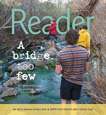
Will Max Lenail's January drowning be enough to get the bridge built?
San Diego River crossing could be eight-figure project
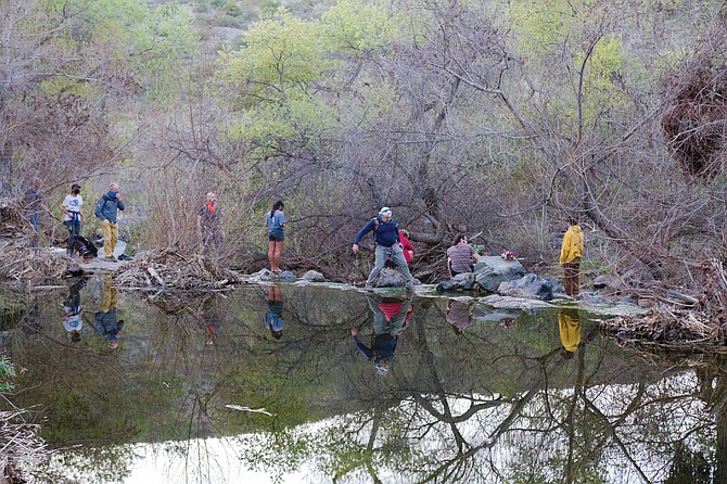
When the water is high enough to flow over the concrete, it comes across as a typical rock crossing. The large, exposed rocks on top are pretty much all you have to work with — everything else is submerged. You must choose your steps and hops wisely.
The San Diego River Crossing Trail intersects the Visitor Center Loop Trail just to the northwest of Mission Trails Regional Park’s Visitor Center. It’s your typical fire road with a moderately steep grade.
On February 4, I arrived at Mission Trails and entered the park at Jackson Drive. I proceeded to head down the trail toward the river. There were two runners ahead of me, and they reached the crossing area before I did. When I caught up with them, they were looking at one another, somewhat bewildered.
“I bet you weren’t expecting this,” I said to them.
“It’s our first time here,” one of them replied. “There wasn’t anything about this on the map we saw online.”
“This” was a swollen San Diego River that made the trail impassable. We were looking at a water crossing that was, judging by a visible marker near the center of the water, about three feet deep and 40 feet wide. And no bridge. The runners turned around and pursued a different route.
They did have an option for getting across, though. It’s an unauthorized route approximately 20 feet to the west of the official crossing area. My guess was that this was a small, aging dam that had been built long before the days of the Fashion Valley Mall — but I was wrong.
“We are kind of speechless that he could have drowned,” Max Lenail’s father explained. “He was extremely fit. An extremely powerful kid. He had done a lot of rock climbing. A lot of mountaineering. A lot of backpacking. He knew the wilderness. He knew nature. He was incredibly strong.”
According to the Mission Trails Master Plan, it’s a “concrete encased sewer main.” It looks like a concrete truck poured all its contents next to the river and a group of workers molded it into sort of elongated pile across the river. Somehow a visible, decaying automobile tire was built into this mess. It’s a massive, unsightly mound of coarse and uneven concrete with some large rocks shoved into it. Even in the realm of sewer structures, it ain’t the belle of the ball.
But this is where people tend to cross. Two seemingly fit guys in their early-20s crossed by way of the encased pipe while I was observing its many quirks. When the water is high enough to flow over the concrete, it comes across as a typical rock crossing. The large, exposed rocks on top are pretty much all you have to work with — everything else is submerged. You must choose your steps and hops wisely. The duo took their time to map out their steps, and they made it across without slipping or falling into the water.
Crossing over the concrete-encased sewer main back on Friday, January 29 was likely much more difficult. A storm system had arrived the previous evening, and by 1 pm had already deposited 1.38 inches of rain at Lake Cuyamaca, 1.29 inches in Point Loma, and 1.12 inches in nearby Santee. Forecasters described the storm as being an “atmospheric river” — a trail of condensed water vapor that travels within the atmosphere in tandem with the weather.
So, when Max Lenail arrived at the river crossing area, heading south, near the end of a long run at close to 2 pm, he was left with a tough decision. He had started his run near the Visitor Center, and now found himself on the other side of a violent river. He had to somehow cross to the other side to get back to his car.

“I was so surprised that there is actually a sign saying, ‘San Diego River Crossing Trail,’ says Laurie, Max’s mother. “Who would think that you would need to go any other way to get across? It was astounding to me, because [Max] probably thought it was the main trail — which was what anyone would have thought.”
At 1:44 pm, he downloaded a map of the park. This would be his last activity on his cell phone. He was likely looking for an alternate route over the river that was nearby, safe, and fast. No such route exists. At some point while he was deciding what course of action to take, he encountered another park visitor who had just successfully navigated the river crossing in the opposite direction. “He actually ran into someone who was going the other way who said, ‘Be very careful,’” Max’s father Ben Lenail said later. “But he made a calculation that he could cross the river — and he drowned.”
Max’s body was recovered from the San Diego River the following day.
Max’s final run is a testament to his athletic prowess. His loop on January 29 started under sunny skies in the Visitor Center parking area from which he ran northeast up to Kwaay Paay peak (1194 feet). He may have even done some moderate rock climbing on this segment, as no official trail from the south leads up to this peak. He then descended that peak and headed northwest toward the Old Mission Dam, where he commenced yet another large climb. This route would eventually turn to the south and lead him up and over South Fortuna peak (1094 feet). The final descent would complete the loop and lead him back toward the Visitor Center and his car. But first, the river.

“The lay of the land is a difficult place to build a bridge. I get it,” Susie Murphy said. “That’s why it hasn’t been done, but it definitely can be done.”
While describing his many athletic talents, Max’s father shared with me that Max had climbed with Alex Honnold in Lake Tahoe. Honnold is a professional rock climber who is famous for scaling the 3000-foot El Capitan rock formation in Yosemite National Park — without climbing equipment. The 2018 documentary Free Solo was about this achievement.
Even though Max was in great shape, he was at the tail end of what was still a tough 5.5-mile run when he reached the crossing. Turning around and running a route that was nearly equal in length (even though he could have eliminated some of the climbs) may have seemed too grueling. And then there was a random weather oddity that arrived, one which may have played a significant role in Max’s decision-making — hail.
“He was basically 15 minutes from the parking lot when he got caught in the hailstorm and felt, ‘I need to find shelter’ and ‘I wanna get back to my car, and I have no choice but to try to cross the river,” his father said.
The timing for the hailstorm checks out. I shot video of it hailing in La Mesa on the same day. That video is time-stamped at 2:09 pm.
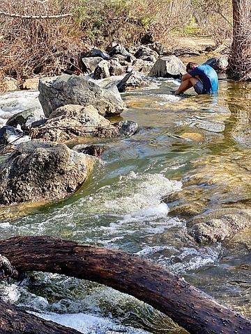
Alex Lenail grieves his brother at the San Diego River crossing where he drowned in January.
“We are kind of speechless that he could have drowned,” Max’s father explained. “He was extremely fit. An extremely powerful kid. He had done a lot of rock climbing. A lot of mountaineering. A lot of backpacking. He knew the wilderness. He knew nature. He was incredibly strong. So, we were like if he died because of the set of circumstances — that crossing is incredibly dangerous. That’s the number one thing. We want to make sure that nobody else gets hurt or killed there ever in the future.”
Max’s mother Laurie Yoler was at the park, observing river crossing activities a few days later, on January 31.
“I was so surprised that there is actually a sign saying, ‘San Diego River Crossing Trail,’ she explained. “Who would think that you would need to go any other way to get across? It was astounding to me, because [Max] probably thought it was the main trail — which was what anyone would have thought. When I went back the next day, I saw hundreds of people going across with their dogs and their babies and their small children, and so many of them were slipping and falling. I was absolutely astounded that [Mission Trails Regional Park] hadn’t either put two park rangers on either side of the river to make sure everyone was crossing safely or had turned people away at the entrance saying, ‘Sorry, it’s too dangerous to take this loop.’ I’m just so astounded.”
She added, “Who would think you would have an uncrossable river on your visitor loop?”
Amid their grief, Max’s parents are now concentrating their efforts on making sure that an official bridge is built in the crossing area.
It’s a feature that the park has had its eye on building as well. The construction of two different bridges was proposed in the 2019 Mission Trails Regional Park Master Plan Update. The first and main bridge would be “an all-weather suspension or truss pedestrian and bicycle bridge across the San Diego River near the San Diego River Crossing Trail.” The second bridge would be more of a temporary alternative to the concrete-enclosed sewer main until the permanent bridge was built. According to the update, “an improved low-flow crossing or seasonal removable bridge structure at the San Diego River Crossing to remove the unauthorized existing use of the concrete encased sewer main, while a bridge option is developed.”
It’s two years later, and not even the temporary alternative to the sewer main crossing has been built. Susie Murphy, executive director of the San Diego Mountain Biking Association, said that the bridge was one of four projects that was prioritized by the Citizen’s Advisory Committee in early 2020, before covid hit. She added that they “were going to attempt to implement all four of those things simultaneously.”
Murphy has followed the park’s dealings for many years now, and the fact that there still isn’t an official bridge in this crossing area obviously gets under her skin.
“I’m appalled. I’m appalled at this whole situation,” she said. “It’s just makes me so angry whenever I think about it. As far as [the association] is concerned, we’re in full support of a bridge. It’s extremely dangerous. We support it as a priority project of the implementation of the Master Plan Update. We’re just concerned for all the families and the people that cross those slimy rocks every day.”
When you take a long look at the crossing area, it becomes a bit more obvious as to why there isn’t a bridge there yet. It’s going to be a large and likely quite expensive project. The bridge will have to stretch over the width of the river, and be raised high enough to avoid the peak floodwater, and be durable enough to withstand the extreme force of floodwater at its base. But beyond that, “The lay of the land is a difficult place to build a bridge. I get it,” Murphy said. “That’s why it hasn’t been done. But it definitely can be done.”
She added, “Mission Trails already has its epic bridges. The one that is over off the Clairemont Mesa trailhead… they’ve done this before. This is not impossible.”
The most recent major project completed in the park was the construction of a 5000-square-foot ranger station located in the East Fortuna Staging Area. It was finished last February at a final cost of $6.6 million. The cost of the river crossing bridge is anybody’s guess, but Max’s parents are eager to start raising the money to get it done.
Max’s father had hoped to work with the Mission Trails Regional Park Foundation in creating a restricted fund earmarked exclusively for construction of the bridge. They are a non-profit organization whose sole purpose is improving the park infrastructure and experience. Unfortunately, this collaboration did not get approved. He is now looking to “leverage another San Diego foundation” to accomplish the same goal.
In the meantime, the family has hired KPFF Consulting Engineers, who are preparing a design and cost estimate for the bridge project.
“If they let us, we would love to have a say on the design, the style,” Max’s father said. “If we end up raising most or all the money, we would love to maybe have a designation or a plaque or a name to honor Max’s memory. Max was very artistic. He was basically a professional-grade glassblower, and a photographer as well. He would have loved to have had a bridge that had a functional utility but also had an aesthetic merit.”
Communications between the Lenail family and Councilmember Raul Campillo’s office revealed a bit of history on the bridge project. An email from the latter revealed that the last time the bridge was discussed was at a Mission Trails Regional Park Citizens Advisory Committee meeting in 2011. “At that time, it was communicated to the Committee that any bridge would have to been constructed with the 100-year flood plain in mind. Thus, the bridge span could be between 320 – 400 feet.” The email further stated, “A project like this will take a great amount of work, preparation and funding. It very well could be an eight figure project. It will require an environmental review process, environmental mitigation, design, engineering, permitting, construction, as well as other things that we may be unaware of at the point in time.”
If an eight-figure project seems a bit expensive, another email sent to Max’s father by Andy Field (director of Parks and Recreation, City of San Diego) may provide another clue. In it, Field states it’s still to be determined “whether the bridge must be usable by both pedestrians as well as vehicles….”
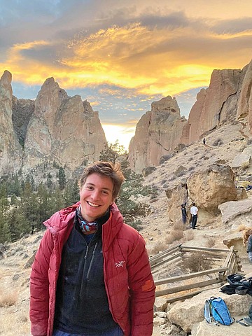
Max Lenail was 21 years old when he drowned in the San Diego River. He was new to the area but had already enjoyed runs around the North Park neighborhood, Mission Trails, and had done some rock climbing at Mount Woodson. He was set to graduate from Brown University in May.
“He loved San Diego, and he was really looking forward to spending the whole semester there,” his father said. “We were going to come visit him with his dog, and it is absolutely inconceivably tragic that he died that way after only a couple of weeks in San Diego.”
Here's something you might be interested in.
Will Max Lenail's January drowning be enough to get the bridge built?
San Diego River crossing could be eight-figure project
Will Max Lenail's January drowning be enough to get the bridge built?
San Diego River crossing could be eight-figure project
When the water is high enough to flow over the concrete, it comes across as a typical rock crossing. The large, exposed rocks on top are pretty much all you have to work with — everything else is submerged. You must choose your steps and hops wisely.
The San Diego River Crossing Trail intersects the Visitor Center Loop Trail just to the northwest of Mission Trails Regional Park’s Visitor Center. It’s your typical fire road with a moderately steep grade.
On February 4, I arrived at Mission Trails and entered the park at Jackson Drive. I proceeded to head down the trail toward the river. There were two runners ahead of me, and they reached the crossing area before I did. When I caught up with them, they were looking at one another, somewhat bewildered.
“I bet you weren’t expecting this,” I said to them.
“It’s our first time here,” one of them replied. “There wasn’t anything about this on the map we saw online.”
“This” was a swollen San Diego River that made the trail impassable. We were looking at a water crossing that was, judging by a visible marker near the center of the water, about three feet deep and 40 feet wide. And no bridge. The runners turned around and pursued a different route.
They did have an option for getting across, though. It’s an unauthorized route approximately 20 feet to the west of the official crossing area. My guess was that this was a small, aging dam that had been built long before the days of the Fashion Valley Mall — but I was wrong.
“We are kind of speechless that he could have drowned,” Max Lenail’s father explained. “He was extremely fit. An extremely powerful kid. He had done a lot of rock climbing. A lot of mountaineering. A lot of backpacking. He knew the wilderness. He knew nature. He was incredibly strong.”
According to the Mission Trails Master Plan, it’s a “concrete encased sewer main.” It looks like a concrete truck poured all its contents next to the river and a group of workers molded it into sort of elongated pile across the river. Somehow a visible, decaying automobile tire was built into this mess. It’s a massive, unsightly mound of coarse and uneven concrete with some large rocks shoved into it. Even in the realm of sewer structures, it ain’t the belle of the ball.
But this is where people tend to cross. Two seemingly fit guys in their early-20s crossed by way of the encased pipe while I was observing its many quirks. When the water is high enough to flow over the concrete, it comes across as a typical rock crossing. The large, exposed rocks on top are pretty much all you have to work with — everything else is submerged. You must choose your steps and hops wisely. The duo took their time to map out their steps, and they made it across without slipping or falling into the water.
Crossing over the concrete-encased sewer main back on Friday, January 29 was likely much more difficult. A storm system had arrived the previous evening, and by 1 pm had already deposited 1.38 inches of rain at Lake Cuyamaca, 1.29 inches in Point Loma, and 1.12 inches in nearby Santee. Forecasters described the storm as being an “atmospheric river” — a trail of condensed water vapor that travels within the atmosphere in tandem with the weather.
So, when Max Lenail arrived at the river crossing area, heading south, near the end of a long run at close to 2 pm, he was left with a tough decision. He had started his run near the Visitor Center, and now found himself on the other side of a violent river. He had to somehow cross to the other side to get back to his car.
“I was so surprised that there is actually a sign saying, ‘San Diego River Crossing Trail,’ says Laurie, Max’s mother. “Who would think that you would need to go any other way to get across? It was astounding to me, because [Max] probably thought it was the main trail — which was what anyone would have thought.”
At 1:44 pm, he downloaded a map of the park. This would be his last activity on his cell phone. He was likely looking for an alternate route over the river that was nearby, safe, and fast. No such route exists. At some point while he was deciding what course of action to take, he encountered another park visitor who had just successfully navigated the river crossing in the opposite direction. “He actually ran into someone who was going the other way who said, ‘Be very careful,’” Max’s father Ben Lenail said later. “But he made a calculation that he could cross the river — and he drowned.”
Max’s body was recovered from the San Diego River the following day.
Max’s final run is a testament to his athletic prowess. His loop on January 29 started under sunny skies in the Visitor Center parking area from which he ran northeast up to Kwaay Paay peak (1194 feet). He may have even done some moderate rock climbing on this segment, as no official trail from the south leads up to this peak. He then descended that peak and headed northwest toward the Old Mission Dam, where he commenced yet another large climb. This route would eventually turn to the south and lead him up and over South Fortuna peak (1094 feet). The final descent would complete the loop and lead him back toward the Visitor Center and his car. But first, the river.
“The lay of the land is a difficult place to build a bridge. I get it,” Susie Murphy said. “That’s why it hasn’t been done, but it definitely can be done.”
While describing his many athletic talents, Max’s father shared with me that Max had climbed with Alex Honnold in Lake Tahoe. Honnold is a professional rock climber who is famous for scaling the 3000-foot El Capitan rock formation in Yosemite National Park — without climbing equipment. The 2018 documentary Free Solo was about this achievement.
Even though Max was in great shape, he was at the tail end of what was still a tough 5.5-mile run when he reached the crossing. Turning around and running a route that was nearly equal in length (even though he could have eliminated some of the climbs) may have seemed too grueling. And then there was a random weather oddity that arrived, one which may have played a significant role in Max’s decision-making — hail.
“He was basically 15 minutes from the parking lot when he got caught in the hailstorm and felt, ‘I need to find shelter’ and ‘I wanna get back to my car, and I have no choice but to try to cross the river,” his father said.
The timing for the hailstorm checks out. I shot video of it hailing in La Mesa on the same day. That video is time-stamped at 2:09 pm.
Alex Lenail grieves his brother at the San Diego River crossing where he drowned in January.
“We are kind of speechless that he could have drowned,” Max’s father explained. “He was extremely fit. An extremely powerful kid. He had done a lot of rock climbing. A lot of mountaineering. A lot of backpacking. He knew the wilderness. He knew nature. He was incredibly strong. So, we were like if he died because of the set of circumstances — that crossing is incredibly dangerous. That’s the number one thing. We want to make sure that nobody else gets hurt or killed there ever in the future.”
Max’s mother Laurie Yoler was at the park, observing river crossing activities a few days later, on January 31.
“I was so surprised that there is actually a sign saying, ‘San Diego River Crossing Trail,’ she explained. “Who would think that you would need to go any other way to get across? It was astounding to me, because [Max] probably thought it was the main trail — which was what anyone would have thought. When I went back the next day, I saw hundreds of people going across with their dogs and their babies and their small children, and so many of them were slipping and falling. I was absolutely astounded that [Mission Trails Regional Park] hadn’t either put two park rangers on either side of the river to make sure everyone was crossing safely or had turned people away at the entrance saying, ‘Sorry, it’s too dangerous to take this loop.’ I’m just so astounded.”
She added, “Who would think you would have an uncrossable river on your visitor loop?”
Amid their grief, Max’s parents are now concentrating their efforts on making sure that an official bridge is built in the crossing area.
It’s a feature that the park has had its eye on building as well. The construction of two different bridges was proposed in the 2019 Mission Trails Regional Park Master Plan Update. The first and main bridge would be “an all-weather suspension or truss pedestrian and bicycle bridge across the San Diego River near the San Diego River Crossing Trail.” The second bridge would be more of a temporary alternative to the concrete-enclosed sewer main until the permanent bridge was built. According to the update, “an improved low-flow crossing or seasonal removable bridge structure at the San Diego River Crossing to remove the unauthorized existing use of the concrete encased sewer main, while a bridge option is developed.”
It’s two years later, and not even the temporary alternative to the sewer main crossing has been built. Susie Murphy, executive director of the San Diego Mountain Biking Association, said that the bridge was one of four projects that was prioritized by the Citizen’s Advisory Committee in early 2020, before covid hit. She added that they “were going to attempt to implement all four of those things simultaneously.”
Murphy has followed the park’s dealings for many years now, and the fact that there still isn’t an official bridge in this crossing area obviously gets under her skin.
“I’m appalled. I’m appalled at this whole situation,” she said. “It’s just makes me so angry whenever I think about it. As far as [the association] is concerned, we’re in full support of a bridge. It’s extremely dangerous. We support it as a priority project of the implementation of the Master Plan Update. We’re just concerned for all the families and the people that cross those slimy rocks every day.”
When you take a long look at the crossing area, it becomes a bit more obvious as to why there isn’t a bridge there yet. It’s going to be a large and likely quite expensive project. The bridge will have to stretch over the width of the river, and be raised high enough to avoid the peak floodwater, and be durable enough to withstand the extreme force of floodwater at its base. But beyond that, “The lay of the land is a difficult place to build a bridge. I get it,” Murphy said. “That’s why it hasn’t been done. But it definitely can be done.”
She added, “Mission Trails already has its epic bridges. The one that is over off the Clairemont Mesa trailhead… they’ve done this before. This is not impossible.”
The most recent major project completed in the park was the construction of a 5000-square-foot ranger station located in the East Fortuna Staging Area. It was finished last February at a final cost of $6.6 million. The cost of the river crossing bridge is anybody’s guess, but Max’s parents are eager to start raising the money to get it done.
Max’s father had hoped to work with the Mission Trails Regional Park Foundation in creating a restricted fund earmarked exclusively for construction of the bridge. They are a non-profit organization whose sole purpose is improving the park infrastructure and experience. Unfortunately, this collaboration did not get approved. He is now looking to “leverage another San Diego foundation” to accomplish the same goal.
In the meantime, the family has hired KPFF Consulting Engineers, who are preparing a design and cost estimate for the bridge project.
“If they let us, we would love to have a say on the design, the style,” Max’s father said. “If we end up raising most or all the money, we would love to maybe have a designation or a plaque or a name to honor Max’s memory. Max was very artistic. He was basically a professional-grade glassblower, and a photographer as well. He would have loved to have had a bridge that had a functional utility but also had an aesthetic merit.”
Communications between the Lenail family and Councilmember Raul Campillo’s office revealed a bit of history on the bridge project. An email from the latter revealed that the last time the bridge was discussed was at a Mission Trails Regional Park Citizens Advisory Committee meeting in 2011. “At that time, it was communicated to the Committee that any bridge would have to been constructed with the 100-year flood plain in mind. Thus, the bridge span could be between 320 – 400 feet.” The email further stated, “A project like this will take a great amount of work, preparation and funding. It very well could be an eight figure project. It will require an environmental review process, environmental mitigation, design, engineering, permitting, construction, as well as other things that we may be unaware of at the point in time.”
If an eight-figure project seems a bit expensive, another email sent to Max’s father by Andy Field (director of Parks and Recreation, City of San Diego) may provide another clue. In it, Field states it’s still to be determined “whether the bridge must be usable by both pedestrians as well as vehicles….”
Max Lenail was 21 years old when he drowned in the San Diego River. He was new to the area but had already enjoyed runs around the North Park neighborhood, Mission Trails, and had done some rock climbing at Mount Woodson. He was set to graduate from Brown University in May.
“He loved San Diego, and he was really looking forward to spending the whole semester there,” his father said. “We were going to come visit him with his dog, and it is absolutely inconceivably tragic that he died that way after only a couple of weeks in San Diego.”