Here's something you might be interested in.
Ask a Hipster — Advice you didn't know you needed
Big Screen — Movie commentary
Blurt — Music's inside track
Booze News — San Diego spirits
Classical Music — Immortal beauty
Classifieds — Free and easy
Close to Home — What it’s like on the street where you live
Cover Stories — Front-page features
Drinks All Around — Bartenders' drink recipes
Excerpts — Literary and spiritual excerpts
Feast! — Food & drink reviews
Feature Stories — Local news & stories
Fishing Report — What’s getting hooked from ship and shore
From the Archives — Spotlight on the past
Golden Dreams — Talk of the town
The Gonzo Report — Making the musical scene, or at least reporting from it
Letters — Our inbox
Movies@Home — Local movie buffs share favorites
Movie Reviews — Our critics' picks and pans
Musician Interviews — Up close with local artists
Neighborhood News from Stringers — Hyperlocal news
News Ticker — News & politics
Obermeyer — San Diego politics illustrated
Outdoors — Weekly changes in flora and fauna
Overheard in San Diego — Eavesdropping illustrated
Poetry — The old and the new
Reader Travel — Travel section built by travelers
Reading — The hunt for intellectuals
Roam-O-Rama — SoCal's best hiking/biking trails
San Diego Beer — Inside San Diego suds
SD on the QT — Almost factual news
Sheep and Goats — Places of worship
Special Issues — The best of
Street Style — San Diego streets have style
Surf Diego — Real stories from those braving the waves
Theater — On stage in San Diego this week
Tin Fork — Silver spoon alternative
Under the Radar — Matt Potter's undercover work
Unforgettable — Long-ago San Diego
Unreal Estate — San Diego's priciest pads
Your Week — Daily event picks
William Heise’s Cedar Trail: a smell reminiscent of shoe polish
There is always something new to explore in this park.
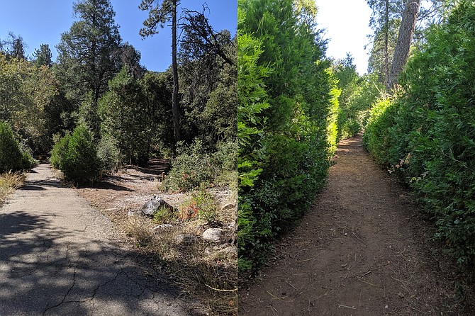
Heading to the trail from the campground area; The trail is short but very inviting
Located at just over 4000 feet elevation, this 929-acre park is a mixture of forest and manzanita chaparral. Over 10 miles of hiking trails, ranging from short and easy to moderately challenging, lie within or originate from this location. There are cabins, trailer sites, individual tent sites, and a group-tent camping area, along with several playgrounds, restrooms with showers, and ample picnic spaces, plus equestrian trails.
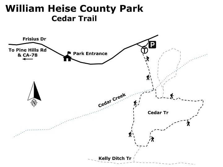
From the parking area, head west through a group picnic area and then descend southward on a paved road to Cedar Creek and the beginning of the mile-long Cedar Trail. Using a clockwise traverse takes the hiker through a gradual and steady ascent through the forested mountainside, which provides some shade. Two trail junctions, each departing from the main trail heading to the left, can be taken if additional hiking is desired. Otherwise, follow the signs for Cedar Trail. Also note the cautionary signs regarding rattlesnakes that might be found on the trail.
Along the trail, watch for birds such as acorn and Nuttall’s woodpeckers, American crow, mountain chickadee, Steller’s and western scrub jays, and Rio Grande wild turkey. Hikers might also notice mammals, such as cottontails, ground squirrels, Merriam’s chipmunk, and mule deer. Plants abound on the trail. Among the overstory, there are incense cedar trees, pines (Ponderosa, Counter, and Jeffrey), black oaks, canyon oaks, coast and interior live oaks. Look for many evergreen shrubs including toyon, chokecherry, dogwood, and ceanothus. Numerous herbaceous understory plants grow here, including snowberry, penstemons, wild rose, strawberry, several types of lupine, bedstraw, horehound, mugwort, and goldenrod.
Upon arriving at the uppermost elevation of the trail some 200 feet above the creek, take some time to enjoy sweeping panoramic views of the surrounding area. Gone is the shaded canopy. A bench provides a place to rest and contemplate the surrounding views. The return trek is a relatively steep drop back to the creek. At the trail junction, go right to complete the loop. The trail to the left leads to Kelly Ditch Trail, Fern Trail, and Potter Loop. As you approach the creek, the trail is once again shaded by the forest canopy. The latter portion of the Cedar Trail can be difficult for aging knees, but going clockwise avoids having to climb this steep terrain, which would be exhausting for many individuals.
One of the things to note on this hike is the reminder of how fire can devastate an area and how nature works to slowly restore itself. The dead tree stumps are from the devastating 2003 Cedar Fire, which burned over 273,000 acres. But the trees are slowly returning. Young cedar saplings are found along the trail, promising lush growth in future years. The California incense cedars (Calocedrus decurrens) can typically reach heights of 130-200 feet, though it will be many years before these saplings reach this height. Note the flattened sprays of scale-like leaves, so typical of cedar trees. When crushed, the smell is reminiscent of shoe polish.
For a description of the park’s Desert View Trail, see the Roam-O-Rama column for January 30, 2013: https://www.sandiegoreader.com/news/2013/jan/30/roam-desert-view-trail-william-heise-county-park/. For more information about William Heise County Park, see the website: http://www.sdparks.org/content/sdparks/en/park-pages/WilliamHeise.html.
William Heise Co Park-Cedar Trail map
WILLIAM HEISE COUNTY PARK – Cedar Trail
There is always something new to explore in this park.
- Driving directions: Julian is approximately 60 miles from downtown San Diego. Go one mile west from Julian toward Santa Isabel on CA-78 to Pine Hill Road. Follow Pine Hill Road for 2 miles to its intersection with Frisius Road. Go left on Frisius Road and continue for another 2 miles to reach the entrance for William Heise County Park. Hiking length: 1.5 miles, loop. The trail is 1 mile, plus it is 0.25 mile from the parking lot to the trailhead and another 0.25 mile back to your vehicle. Difficulty: Easy. Total elevation gain/loss is approximately 280 feet. Hikers, walkers, bikers, and leashed dogs allowed. Facilities are available at the parking area; there is a $3.00 cost for parking and use of facilities. The trail is well graded and typically 6-10 feet in width. A clockwise direction of the loop is recommended for most hikers.
Here's something you might be interested in.
William Heise’s Cedar Trail: a smell reminiscent of shoe polish
There is always something new to explore in this park.
William Heise’s Cedar Trail: a smell reminiscent of shoe polish
There is always something new to explore in this park.
Heading to the trail from the campground area; The trail is short but very inviting
Located at just over 4000 feet elevation, this 929-acre park is a mixture of forest and manzanita chaparral. Over 10 miles of hiking trails, ranging from short and easy to moderately challenging, lie within or originate from this location. There are cabins, trailer sites, individual tent sites, and a group-tent camping area, along with several playgrounds, restrooms with showers, and ample picnic spaces, plus equestrian trails.
From the parking area, head west through a group picnic area and then descend southward on a paved road to Cedar Creek and the beginning of the mile-long Cedar Trail. Using a clockwise traverse takes the hiker through a gradual and steady ascent through the forested mountainside, which provides some shade. Two trail junctions, each departing from the main trail heading to the left, can be taken if additional hiking is desired. Otherwise, follow the signs for Cedar Trail. Also note the cautionary signs regarding rattlesnakes that might be found on the trail.
Along the trail, watch for birds such as acorn and Nuttall’s woodpeckers, American crow, mountain chickadee, Steller’s and western scrub jays, and Rio Grande wild turkey. Hikers might also notice mammals, such as cottontails, ground squirrels, Merriam’s chipmunk, and mule deer. Plants abound on the trail. Among the overstory, there are incense cedar trees, pines (Ponderosa, Counter, and Jeffrey), black oaks, canyon oaks, coast and interior live oaks. Look for many evergreen shrubs including toyon, chokecherry, dogwood, and ceanothus. Numerous herbaceous understory plants grow here, including snowberry, penstemons, wild rose, strawberry, several types of lupine, bedstraw, horehound, mugwort, and goldenrod.
Upon arriving at the uppermost elevation of the trail some 200 feet above the creek, take some time to enjoy sweeping panoramic views of the surrounding area. Gone is the shaded canopy. A bench provides a place to rest and contemplate the surrounding views. The return trek is a relatively steep drop back to the creek. At the trail junction, go right to complete the loop. The trail to the left leads to Kelly Ditch Trail, Fern Trail, and Potter Loop. As you approach the creek, the trail is once again shaded by the forest canopy. The latter portion of the Cedar Trail can be difficult for aging knees, but going clockwise avoids having to climb this steep terrain, which would be exhausting for many individuals.
One of the things to note on this hike is the reminder of how fire can devastate an area and how nature works to slowly restore itself. The dead tree stumps are from the devastating 2003 Cedar Fire, which burned over 273,000 acres. But the trees are slowly returning. Young cedar saplings are found along the trail, promising lush growth in future years. The California incense cedars (Calocedrus decurrens) can typically reach heights of 130-200 feet, though it will be many years before these saplings reach this height. Note the flattened sprays of scale-like leaves, so typical of cedar trees. When crushed, the smell is reminiscent of shoe polish.
For a description of the park’s Desert View Trail, see the Roam-O-Rama column for January 30, 2013: https://www.sandiegoreader.com/news/2013/jan/30/roam-desert-view-trail-william-heise-county-park/. For more information about William Heise County Park, see the website: http://www.sdparks.org/content/sdparks/en/park-pages/WilliamHeise.html.
William Heise Co Park-Cedar Trail map
WILLIAM HEISE COUNTY PARK – Cedar Trail
There is always something new to explore in this park.
- Driving directions: Julian is approximately 60 miles from downtown San Diego. Go one mile west from Julian toward Santa Isabel on CA-78 to Pine Hill Road. Follow Pine Hill Road for 2 miles to its intersection with Frisius Road. Go left on Frisius Road and continue for another 2 miles to reach the entrance for William Heise County Park. Hiking length: 1.5 miles, loop. The trail is 1 mile, plus it is 0.25 mile from the parking lot to the trailhead and another 0.25 mile back to your vehicle. Difficulty: Easy. Total elevation gain/loss is approximately 280 feet. Hikers, walkers, bikers, and leashed dogs allowed. Facilities are available at the parking area; there is a $3.00 cost for parking and use of facilities. The trail is well graded and typically 6-10 feet in width. A clockwise direction of the loop is recommended for most hikers.