Here's something you might be interested in.
Ask a Hipster — Advice you didn't know you needed
Big Screen — Movie commentary
Blurt — Music's inside track
Booze News — San Diego spirits
Classical Music — Immortal beauty
Classifieds — Free and easy
Close to Home — What it’s like on the street where you live
Cover Stories — Front-page features
Drinks All Around — Bartenders' drink recipes
Excerpts — Literary and spiritual excerpts
Feast! — Food & drink reviews
Feature Stories — Local news & stories
Fishing Report — What’s getting hooked from ship and shore
From the Archives — Spotlight on the past
Golden Dreams — Talk of the town
The Gonzo Report — Making the musical scene, or at least reporting from it
Letters — Our inbox
Movies@Home — Local movie buffs share favorites
Movie Reviews — Our critics' picks and pans
Musician Interviews — Up close with local artists
Neighborhood News from Stringers — Hyperlocal news
News Ticker — News & politics
Obermeyer — San Diego politics illustrated
Outdoors — Weekly changes in flora and fauna
Overheard in San Diego — Eavesdropping illustrated
Poetry — The old and the new
Reader Travel — Travel section built by travelers
Reading — The hunt for intellectuals
Roam-O-Rama — SoCal's best hiking/biking trails
San Diego Beer — Inside San Diego suds
SD on the QT — Almost factual news
Sheep and Goats — Places of worship
Special Issues — The best of
Street Style — San Diego streets have style
Surf Diego — Real stories from those braving the waves
Theater — On stage in San Diego this week
Tin Fork — Silver spoon alternative
Under the Radar — Matt Potter's undercover work
Unforgettable — Long-ago San Diego
Unreal Estate — San Diego's priciest pads
Your Week — Daily event picks
Visit Santee’s Rattlesnake Mountain... but stay on the trail
This short hike leads to a spectacular view of East County
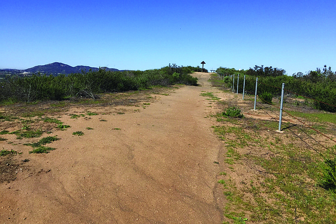
The trail leads to the viewpoint
Rattlesnake Mountain is best known to East County residents as the mountain that has the illuminated star during the holiday season that is visible for miles. It is just east of Gillespie Field. Apart from that, many do not know its actual name or that it is a 368-acre preserve located in the southeast quadrant of the City of Santee, just west of the intersection of State Routes 52 and 67. It is part of Santee’s Multiple Species Conservation Program and is owned, protected, and managed by the Center for Natural Lands Management (CNLM), a non-profit organization with over 70 preserves in the State of California. CNLM acquired the land between 2007 and 2012 as mitigation for lands being developed in the area.
The purpose of the CNLM is to preserve the land and to protect the native plants and animals ahead of promoting human exercise trails. This is a challenge here in that a community called Sky Ranch surrounds the mountaintop. Species of special interest to CNLM include the federally listed, threatened coastal California gnatcatcher, coast horned lizard, orange-throated whiptail, barrel cactus, Cleveland’s goldenstar, and the red-diamond rattlesnake. It is one of the largest areas of undeveloped coastal sage scrub and native and nonnative grasslands in the City of Santee.
From the trailhead at the corner of Mariposa Street and Morella Street, follow the wide and rocky dirt trail uphill about 200 yards to the mountaintop, which is surrounded by coastal sage scrub habitat. The trail is bordered by native plants such as sagebrush, flat-top buckwheat, broom baccharis, San Diego sunflower, deerweed, and wild cucumber, There are no trees or shrubs along the way, so there is no shade. This allows for 360-degree views of El Cajon Mountain, El Cajon Valley, Lakeside, Santee, and distant mountains. It is also a good place to view planes taking off and landing at Gillespie Field. The summit has an information board and benches on which to sit and rest.
Stay on the trail as there is no trespassing on CNLM lands off the trail. Spring flowers include beautiful lupine, poppies, monkey flowers, blue dicks, mallow, and wild rose and hyacinths.
You might also spot a hillside of yellow mustard, a non-native and invasive plant. It is very pretty in bloom, but it spreads and becomes dense, crowding out the beautiful flowers listed above. The plants dry out and die, leaving dry fuel for wildfires. The primary task for the CNLM is to remove the mustards by hand and replace them with native plants.
As is the case with all trails year round, rattlesnakes are always a possible danger on the trail. When walking, stay on the trail, and keep dogs on a leash. Snakes are cold-blooded, which means they rely on the warmth of the sun to warm their bodies so they can move and function. Common warming places arein the middle of a trail, or in rock piles, boulders, and grasses. What to do if you encounter a snake on the trail? Stop! Wait and watch at a safe distance. The snake will most likely leave the trail. Don’t threaten it by throwing sticks and stones, because this will only make the snake angry and want to protect itself by striking and biting! The snake may rattle to let you know it’s there and is threatened, but not always. Bites are seldom fatal if you receive the anti-venom within two hours. So prompt treatment is important.
There are a couple of options to extend this excursion. If you park your vehicle on Cala Lily Street, you can begin and end your hike at Santee’s Sky Ranch Park, where there are tables, playground equipment, water, and a short circular paved trail, good for small children. The round-trip distance from the park to the mountaintop and back via city streets is almost 1 mile with an elevation gain of 200 feet.
If the chain link fence is open on Morella Street, you can also follow this paved road to the end and back for another half-mile for more views and a look at some different plants along the downslope that include laurel sumac, arroyo willow, mule fat, and cottonwood trees. Unfortunately, there is also the invasive salt cedar tamarisk that crowds out other riparian plants.
RATTLESNAKE MOUNTAIN PRESERVE – SANTEE
This short hike leads to a spectacular view of East County
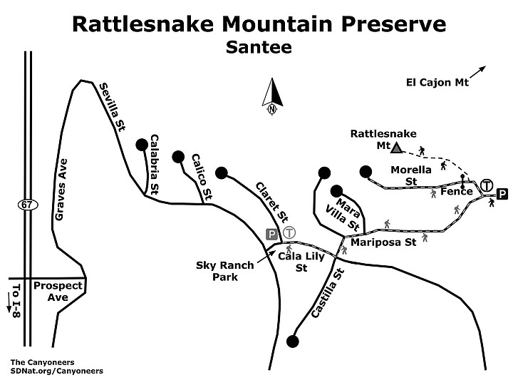
Rattlesnake Mountain Preserve map
Driving directions: (Santee) From I-8, go north on Hwy 67, and exit onto Prospect Avenue (exit 2), and immediately turn left onto Graves Avenue. Continue on Graves, which becomes Sevilla when the road turns right. After 0.5 mile on Sevilla, turn left onto Cala Lily Street. Turn left onto Castilla Street, and then right onto Mariposa Street. There is no parking at the trailhead on Mariposa Street. Morella Street at the trailhead has a chain link fence that may be closed. It is best to continue uphill on Mariposa Street 0.1 mile where parking is allowed on the street, and then walk back down to the trailhead. Hiking length: Less than a half-mile out-and-back. Elevation gain/loss is 55 feet. Allow 30 minutes. Longer options are available. Difficulty: Easy. Leashed dogs permitted. Best time is morning, late afternoon, or early evening. Good for sunrises and sunsets.
Here's something you might be interested in.
Visit Santee’s Rattlesnake Mountain... but stay on the trail
This short hike leads to a spectacular view of East County
Visit Santee’s Rattlesnake Mountain... but stay on the trail
This short hike leads to a spectacular view of East County
The trail leads to the viewpoint
Rattlesnake Mountain is best known to East County residents as the mountain that has the illuminated star during the holiday season that is visible for miles. It is just east of Gillespie Field. Apart from that, many do not know its actual name or that it is a 368-acre preserve located in the southeast quadrant of the City of Santee, just west of the intersection of State Routes 52 and 67. It is part of Santee’s Multiple Species Conservation Program and is owned, protected, and managed by the Center for Natural Lands Management (CNLM), a non-profit organization with over 70 preserves in the State of California. CNLM acquired the land between 2007 and 2012 as mitigation for lands being developed in the area.
The purpose of the CNLM is to preserve the land and to protect the native plants and animals ahead of promoting human exercise trails. This is a challenge here in that a community called Sky Ranch surrounds the mountaintop. Species of special interest to CNLM include the federally listed, threatened coastal California gnatcatcher, coast horned lizard, orange-throated whiptail, barrel cactus, Cleveland’s goldenstar, and the red-diamond rattlesnake. It is one of the largest areas of undeveloped coastal sage scrub and native and nonnative grasslands in the City of Santee.
From the trailhead at the corner of Mariposa Street and Morella Street, follow the wide and rocky dirt trail uphill about 200 yards to the mountaintop, which is surrounded by coastal sage scrub habitat. The trail is bordered by native plants such as sagebrush, flat-top buckwheat, broom baccharis, San Diego sunflower, deerweed, and wild cucumber, There are no trees or shrubs along the way, so there is no shade. This allows for 360-degree views of El Cajon Mountain, El Cajon Valley, Lakeside, Santee, and distant mountains. It is also a good place to view planes taking off and landing at Gillespie Field. The summit has an information board and benches on which to sit and rest.
Stay on the trail as there is no trespassing on CNLM lands off the trail. Spring flowers include beautiful lupine, poppies, monkey flowers, blue dicks, mallow, and wild rose and hyacinths.
You might also spot a hillside of yellow mustard, a non-native and invasive plant. It is very pretty in bloom, but it spreads and becomes dense, crowding out the beautiful flowers listed above. The plants dry out and die, leaving dry fuel for wildfires. The primary task for the CNLM is to remove the mustards by hand and replace them with native plants.
As is the case with all trails year round, rattlesnakes are always a possible danger on the trail. When walking, stay on the trail, and keep dogs on a leash. Snakes are cold-blooded, which means they rely on the warmth of the sun to warm their bodies so they can move and function. Common warming places arein the middle of a trail, or in rock piles, boulders, and grasses. What to do if you encounter a snake on the trail? Stop! Wait and watch at a safe distance. The snake will most likely leave the trail. Don’t threaten it by throwing sticks and stones, because this will only make the snake angry and want to protect itself by striking and biting! The snake may rattle to let you know it’s there and is threatened, but not always. Bites are seldom fatal if you receive the anti-venom within two hours. So prompt treatment is important.
There are a couple of options to extend this excursion. If you park your vehicle on Cala Lily Street, you can begin and end your hike at Santee’s Sky Ranch Park, where there are tables, playground equipment, water, and a short circular paved trail, good for small children. The round-trip distance from the park to the mountaintop and back via city streets is almost 1 mile with an elevation gain of 200 feet.
If the chain link fence is open on Morella Street, you can also follow this paved road to the end and back for another half-mile for more views and a look at some different plants along the downslope that include laurel sumac, arroyo willow, mule fat, and cottonwood trees. Unfortunately, there is also the invasive salt cedar tamarisk that crowds out other riparian plants.
RATTLESNAKE MOUNTAIN PRESERVE – SANTEE
This short hike leads to a spectacular view of East County
Rattlesnake Mountain Preserve map
Driving directions: (Santee) From I-8, go north on Hwy 67, and exit onto Prospect Avenue (exit 2), and immediately turn left onto Graves Avenue. Continue on Graves, which becomes Sevilla when the road turns right. After 0.5 mile on Sevilla, turn left onto Cala Lily Street. Turn left onto Castilla Street, and then right onto Mariposa Street. There is no parking at the trailhead on Mariposa Street. Morella Street at the trailhead has a chain link fence that may be closed. It is best to continue uphill on Mariposa Street 0.1 mile where parking is allowed on the street, and then walk back down to the trailhead. Hiking length: Less than a half-mile out-and-back. Elevation gain/loss is 55 feet. Allow 30 minutes. Longer options are available. Difficulty: Easy. Leashed dogs permitted. Best time is morning, late afternoon, or early evening. Good for sunrises and sunsets.
Comments