Here's something you might be interested in.
Ask a Hipster — Advice you didn't know you needed
Big Screen — Movie commentary
Blurt — Music's inside track
Booze News — San Diego spirits
Classical Music — Immortal beauty
Classifieds — Free and easy
Close to Home — What it’s like on the street where you live
Cover Stories — Front-page features
Drinks All Around — Bartenders' drink recipes
Excerpts — Literary and spiritual excerpts
Feast! — Food & drink reviews
Feature Stories — Local news & stories
Fishing Report — What’s getting hooked from ship and shore
From the Archives — Spotlight on the past
Golden Dreams — Talk of the town
The Gonzo Report — Making the musical scene, or at least reporting from it
Letters — Our inbox
Movies@Home — Local movie buffs share favorites
Movie Reviews — Our critics' picks and pans
Musician Interviews — Up close with local artists
Neighborhood News from Stringers — Hyperlocal news
News Ticker — News & politics
Obermeyer — San Diego politics illustrated
Outdoors — Weekly changes in flora and fauna
Overheard in San Diego — Eavesdropping illustrated
Poetry — The old and the new
Reader Travel — Travel section built by travelers
Reading — The hunt for intellectuals
Roam-O-Rama — SoCal's best hiking/biking trails
San Diego Beer — Inside San Diego suds
SD on the QT — Almost factual news
Sheep and Goats — Places of worship
Special Issues — The best of
Street Style — San Diego streets have style
Surf Diego — Real stories from those braving the waves
Theater — On stage in San Diego this week
Tin Fork — Silver spoon alternative
Under the Radar — Matt Potter's undercover work
Unforgettable — Long-ago San Diego
Unreal Estate — San Diego's priciest pads
Your Week — Daily event picks
The Sentenac Birding Trail: from San Felipe Creek migratory bird wetland to smaller resident bird shelter
Enjoy Sentenac Cienega while birdwatching
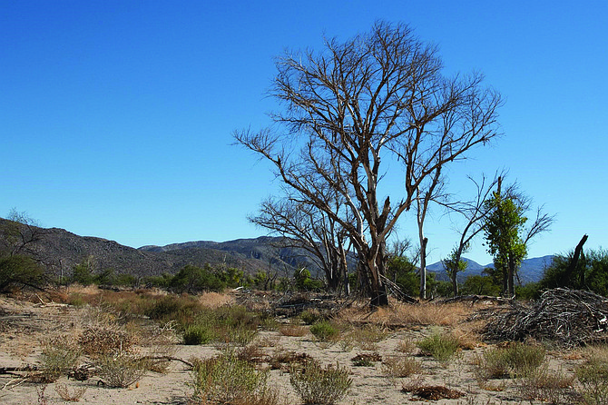
The dead and dying trees in Sentenac Cienega
The Birding Trail was established at a time when San Felipe Creek discharged into a large wetland, or cienega, with intermittent pools of open water. It was an important stop for migratory birds. The pools of open water have vanished in these recent dry years, so you are unlikely to view migratory waterfowl from the birding trail. However, numerous smaller birds that enjoy the shelter provided by the mesquite (Prosopis glandulosa) thickets found here are available for viewing from this short trail.
Start hiking north from the S-2 on the Pacific Crest Trail. As you descend the gentle hill on the PCT, shortly before you reach San Felipe Wash, look for a faded sign on your right for the Sentenac Birding Trail. The Birding Trail leads east from this sign, almost parallel to, but below and separated from the S-2 highway. It is marked by intermittent posts with small white signs or arrows. The trail isn’t well maintained, so it requires some maneuvering around or through various obstacles. Initially, these include dead or dying mesquite trees, but within a quarter of a mile, you begin to encounter living mesquite trees, more evenly spaced and usually easy to detour around. At about 1.2 miles from the trailhead, you will find it very difficult to find a way around the mesquite now blocking the path, so it’s a good place to turn around.
But if you came to see birds, here is the place to stop hiking and remain, quietly observing the brush for signs of activity. Birds that have been seen here include Bewick’s wren, Wilson’s warbler, the lesser goldfinch, black-tailed gnatcatcher, the common yellowthroat, mourning doves, bushtits, and red-tailed hawks. You are most likely to see some or all of these species in the spring or fall.
You might also see a brown-headed cowbird, which is known to parasitize the nests of other birds. They are still occasionally seen in the spring, but their numbers are declining due to a successful effort to trap and destroy them. One such trap was set up near the Birding Trail.
If you have time and want to see the Sentenac Cienega, it is still here — just shrunken from what it was. There is no marked trail leading to it, but if you continue up the PCT, just after passing the Hwy-78 bridge crossing San Felipe Creek bed, look for a signed “Nature Trail” off to the right, near a gap in the fence. Follow this down to the San Felipe Wash, then continue hiking east along the wash. At first you will see scattered dead and dying mesquite and cottonwood (Populus fremontii) trees, but as you continue, you will see more signs of life. in individuals of both of these species. They also become more numerous. After about 0.75 mile, the wash spreads out and becomes less distinct as it enters a grassland with scattered trees. Turn in a northeasterly direction, hiking toward the thicket of trees ahead: willows, cottonwoods, and mesquite. These trees have found water and also have created an impenetrable barrier making this a good place to turn back.
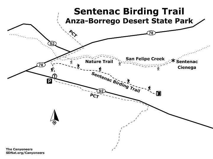
Sentenac Birding Trail map
- SENTENAC BIRDING TRAIL (Anza-Borrego Desert State Park)
- Drought has changed the focus from migratory birds to resident birds
- Driving directions: Drive to Julian either via Hwy 78 from Ramona or from I-8 East, taking exit 40 for Hwy-79 going north until it intersects with Hwy-78 in Julian and then turn right (east). Proceed down Hwy-78 via Banner Grade, then east to Scissors Crossing. Turn right onto S-2 and drive 0.3 mile to where the Pacific Crest Trail crosses S-2 and park. Hiking length: 2.4 miles, out-and-back, with an optional hike to the cienega that would add an additional 2 miles. Difficulty: Easy with negligible elevation gain. The main hazards are the sharp thorns of the mesquite and the ripping claws of the less numerous catclaw (Senegalia greggii) shrubs. Equestrians are allowed only on the PCT and always have the right of way on the trail.
Here's something you might be interested in.
The Sentenac Birding Trail: from San Felipe Creek migratory bird wetland to smaller resident bird shelter
Enjoy Sentenac Cienega while birdwatching
The Sentenac Birding Trail: from San Felipe Creek migratory bird wetland to smaller resident bird shelter
Enjoy Sentenac Cienega while birdwatching
The dead and dying trees in Sentenac Cienega
The Birding Trail was established at a time when San Felipe Creek discharged into a large wetland, or cienega, with intermittent pools of open water. It was an important stop for migratory birds. The pools of open water have vanished in these recent dry years, so you are unlikely to view migratory waterfowl from the birding trail. However, numerous smaller birds that enjoy the shelter provided by the mesquite (Prosopis glandulosa) thickets found here are available for viewing from this short trail.
Start hiking north from the S-2 on the Pacific Crest Trail. As you descend the gentle hill on the PCT, shortly before you reach San Felipe Wash, look for a faded sign on your right for the Sentenac Birding Trail. The Birding Trail leads east from this sign, almost parallel to, but below and separated from the S-2 highway. It is marked by intermittent posts with small white signs or arrows. The trail isn’t well maintained, so it requires some maneuvering around or through various obstacles. Initially, these include dead or dying mesquite trees, but within a quarter of a mile, you begin to encounter living mesquite trees, more evenly spaced and usually easy to detour around. At about 1.2 miles from the trailhead, you will find it very difficult to find a way around the mesquite now blocking the path, so it’s a good place to turn around.
But if you came to see birds, here is the place to stop hiking and remain, quietly observing the brush for signs of activity. Birds that have been seen here include Bewick’s wren, Wilson’s warbler, the lesser goldfinch, black-tailed gnatcatcher, the common yellowthroat, mourning doves, bushtits, and red-tailed hawks. You are most likely to see some or all of these species in the spring or fall.
You might also see a brown-headed cowbird, which is known to parasitize the nests of other birds. They are still occasionally seen in the spring, but their numbers are declining due to a successful effort to trap and destroy them. One such trap was set up near the Birding Trail.
If you have time and want to see the Sentenac Cienega, it is still here — just shrunken from what it was. There is no marked trail leading to it, but if you continue up the PCT, just after passing the Hwy-78 bridge crossing San Felipe Creek bed, look for a signed “Nature Trail” off to the right, near a gap in the fence. Follow this down to the San Felipe Wash, then continue hiking east along the wash. At first you will see scattered dead and dying mesquite and cottonwood (Populus fremontii) trees, but as you continue, you will see more signs of life. in individuals of both of these species. They also become more numerous. After about 0.75 mile, the wash spreads out and becomes less distinct as it enters a grassland with scattered trees. Turn in a northeasterly direction, hiking toward the thicket of trees ahead: willows, cottonwoods, and mesquite. These trees have found water and also have created an impenetrable barrier making this a good place to turn back.
Sentenac Birding Trail map
- SENTENAC BIRDING TRAIL (Anza-Borrego Desert State Park)
- Drought has changed the focus from migratory birds to resident birds
- Driving directions: Drive to Julian either via Hwy 78 from Ramona or from I-8 East, taking exit 40 for Hwy-79 going north until it intersects with Hwy-78 in Julian and then turn right (east). Proceed down Hwy-78 via Banner Grade, then east to Scissors Crossing. Turn right onto S-2 and drive 0.3 mile to where the Pacific Crest Trail crosses S-2 and park. Hiking length: 2.4 miles, out-and-back, with an optional hike to the cienega that would add an additional 2 miles. Difficulty: Easy with negligible elevation gain. The main hazards are the sharp thorns of the mesquite and the ripping claws of the less numerous catclaw (Senegalia greggii) shrubs. Equestrians are allowed only on the PCT and always have the right of way on the trail.