Here's something you might be interested in.
Ask a Hipster — Advice you didn't know you needed
Big Screen — Movie commentary
Blurt — Music's inside track
Booze News — San Diego spirits
Classical Music — Immortal beauty
Classifieds — Free and easy
Cover Stories — Front-page features
Drinks All Around — Bartenders' drink recipes
Excerpts — Literary and spiritual excerpts
Feast! — Food & drink reviews
Feature Stories — Local news & stories
Fishing Report — What’s getting hooked from ship and shore
From the Archives — Spotlight on the past
Golden Dreams — Talk of the town
The Gonzo Report — Making the musical scene, or at least reporting from it
Letters — Our inbox
Movies@Home — Local movie buffs share favorites
Movie Reviews — Our critics' picks and pans
Musician Interviews — Up close with local artists
Neighborhood News from Stringers — Hyperlocal news
News Ticker — News & politics
Obermeyer — San Diego politics illustrated
Outdoors — Weekly changes in flora and fauna
Overheard in San Diego — Eavesdropping illustrated
Poetry — The old and the new
Reader Travel — Travel section built by travelers
Reading — The hunt for intellectuals
Roam-O-Rama — SoCal's best hiking/biking trails
San Diego Beer — Inside San Diego suds
SD on the QT — Almost factual news
Sheep and Goats — Places of worship
Special Issues — The best of
Street Style — San Diego streets have style
Surf Diego — Real stories from those braving the waves
Theater — On stage in San Diego this week
Tin Fork — Silver spoon alternative
Under the Radar — Matt Potter's undercover work
Unforgettable — Long-ago San Diego
Unreal Estate — San Diego's priciest pads
Your Week — Daily event picks
Harper Canyon: home to ironwood trees, dramatic geology and desert bighorn sheep
This remote Anza-Borrego canyon is for the experienced hiker
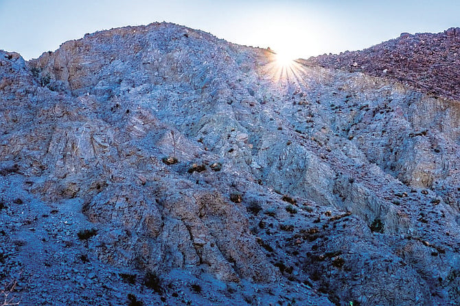
The canyon walls are almost barren
Harper Canyon is home to hundreds of magnificent ironwood trees (Olneya terota). They can become quite large and, though the pinnately compound leaves don’t provide abundant shade, they are evergreen and attractive year around. Since they are nitrogen-fixing members of the pea family, they help enrich the sandy desert soil. The canyon also has dramatic geology with huge boulders that may have fallen recently from the steep, highly eroded canyon walls. It also appears to house a resident population of desert bighorn sheep (Ovis canadensis nelsoni). The canyon was named for the Harper family, who raised cattle and began taking their cattle down to the desert for winter grazing around the turn of the last century. In earlier times, this area was used by desert Indians.
Hikers should have some previous experience with desert hiking and route finding. This hike is best done after the rains come and the wildflowers begin to appear, usually from late January through April. This becomes a significantly longer hike if you must start hiking from Kane Springs Road, but there are benefits in doing so. It gives you an opportunity to visit the Cactus Garden, where you will find representatives of nine of the 16 different cacti growing in the ABDSP. While many of these cacti are now stressed due to the ongoing drought, most will survive if there is sufficient rain over the next several years. The same is true for the many ironwood trees found scattered throughout the Harper Canyon bajada. Once you enter the canyon and begin hiking on the wide sandy creek bed, most of the abundant ironwood trees appear healthy and green, in contrast to those on the bajada. This suggests that the canyon ironwood roots may have tapped underground aquifers that are not available to trees on the bajada.
A striking observation as you progress up the canyon is the starkness of the canyon walls. Several of the tributary canyons house a jumble of boulders, many of which appear to be poised to tumble into the main canyon after the next earthquake or intense flash flood. You will come to piles of such boulders at increasingly short intervals as you make your way up the canyon. These obstacles can be overcome by following the ducks that indicate a way over or around the barrier.
Look for signs of desert bighorn sheep in the sandy washes. Piles of sheep scat are common, as well as hoof prints in soft mud if it has rained recently. If you are quiet and observe the canyon slopes and ridges carefully, you might see some sheep watching you. It is a bit of a mystery as to where they get their water, as there are no known sources anywhere near here.
While the vegetation on the steep canyon walls is sparse, there is a wide array of plants on the canyon bottom. In addition to the many ironwood trees, catclaw acacia (Senegalia greggii) and desert lavender (Condea emoryi) are abundant. Wildflowers such as wild heliotrope, rush sweetbush, ghost flower, tansy mustard, Emory’s rock daisy, and Parish’s gold-poppy are among the 150 plants that were found growing in the canyon by Tom Chester and his co-workers (see tchester.org for their checklist).
After you have hiked about 3 miles from the canyon trailhead (or 4.8 miles from Kane Springs Road), the trail goes through huge slabs of sharply tilted, fractured rock. This may be a good place to turn around and go back the way you came. Harper Flat is about a mile ahead—although it is well worth a visit for its rich archeological artifacts, there are better ways to get there.
HARPER CANYON (Anza-Borrego Desert State Park)
This remote canyon is for the experienced hiker.
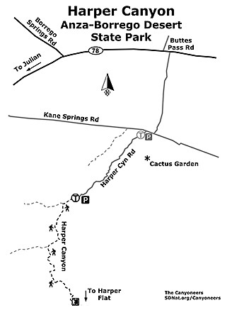
Harper Canyon map
- Driving directions: Drive to Julian. From the intersection of Hwy. 79 and Hwy. 78 (at the US Post Office), go east on Hwy. 78 and continue for 28.7 miles to a dirt road on the right (south) that is 0.2 mile east of the signed Buttes Pass Road on the left (north). Turn right on this road. You reach Kane Springs Road after driving 1.6 miles south through occasionally deep sand. Go right on Kane Springs Road and continue for about 300 yards, then find the unsigned Harper Canyon Road branching off to the left and continue south. This road is nearly impassable without a rugged 4WD vehicle. There are several short dead ends to confuse you. However, with the right vehicle and skill, you will reach the end of the road in the mouth of the canyon in about 1.8 miles. If you are concerned about your vehicle’s ability to survive this last stretch, park on Kane Springs Road and walk into the canyon, adding 3.6 miles to your hike, out-and-back. Hiking length: This is a moderately strenuous to strenuous 6-mile out-and-back hike. It can be completed in 3-4 hours. Difficulty: The hike alternates between easy walking in soft sand washes and scrambling over piles of boulders, some of which are quite large. Ducks (piles of three or more stones) mark most of the difficult passages. The total ascent is about 800 feet. There are no sources of water in the canyon. Trekking poles recommended. Dogs, mountain bikes, and equestrians not allowed on trails in ABDSP.
Here's something you might be interested in.
Harper Canyon: home to ironwood trees, dramatic geology and desert bighorn sheep
This remote Anza-Borrego canyon is for the experienced hiker
Harper Canyon: home to ironwood trees, dramatic geology and desert bighorn sheep
This remote Anza-Borrego canyon is for the experienced hiker
The canyon walls are almost barren
Harper Canyon is home to hundreds of magnificent ironwood trees (Olneya terota). They can become quite large and, though the pinnately compound leaves don’t provide abundant shade, they are evergreen and attractive year around. Since they are nitrogen-fixing members of the pea family, they help enrich the sandy desert soil. The canyon also has dramatic geology with huge boulders that may have fallen recently from the steep, highly eroded canyon walls. It also appears to house a resident population of desert bighorn sheep (Ovis canadensis nelsoni). The canyon was named for the Harper family, who raised cattle and began taking their cattle down to the desert for winter grazing around the turn of the last century. In earlier times, this area was used by desert Indians.
Hikers should have some previous experience with desert hiking and route finding. This hike is best done after the rains come and the wildflowers begin to appear, usually from late January through April. This becomes a significantly longer hike if you must start hiking from Kane Springs Road, but there are benefits in doing so. It gives you an opportunity to visit the Cactus Garden, where you will find representatives of nine of the 16 different cacti growing in the ABDSP. While many of these cacti are now stressed due to the ongoing drought, most will survive if there is sufficient rain over the next several years. The same is true for the many ironwood trees found scattered throughout the Harper Canyon bajada. Once you enter the canyon and begin hiking on the wide sandy creek bed, most of the abundant ironwood trees appear healthy and green, in contrast to those on the bajada. This suggests that the canyon ironwood roots may have tapped underground aquifers that are not available to trees on the bajada.
A striking observation as you progress up the canyon is the starkness of the canyon walls. Several of the tributary canyons house a jumble of boulders, many of which appear to be poised to tumble into the main canyon after the next earthquake or intense flash flood. You will come to piles of such boulders at increasingly short intervals as you make your way up the canyon. These obstacles can be overcome by following the ducks that indicate a way over or around the barrier.
Look for signs of desert bighorn sheep in the sandy washes. Piles of sheep scat are common, as well as hoof prints in soft mud if it has rained recently. If you are quiet and observe the canyon slopes and ridges carefully, you might see some sheep watching you. It is a bit of a mystery as to where they get their water, as there are no known sources anywhere near here.
While the vegetation on the steep canyon walls is sparse, there is a wide array of plants on the canyon bottom. In addition to the many ironwood trees, catclaw acacia (Senegalia greggii) and desert lavender (Condea emoryi) are abundant. Wildflowers such as wild heliotrope, rush sweetbush, ghost flower, tansy mustard, Emory’s rock daisy, and Parish’s gold-poppy are among the 150 plants that were found growing in the canyon by Tom Chester and his co-workers (see tchester.org for their checklist).
After you have hiked about 3 miles from the canyon trailhead (or 4.8 miles from Kane Springs Road), the trail goes through huge slabs of sharply tilted, fractured rock. This may be a good place to turn around and go back the way you came. Harper Flat is about a mile ahead—although it is well worth a visit for its rich archeological artifacts, there are better ways to get there.
HARPER CANYON (Anza-Borrego Desert State Park)
This remote canyon is for the experienced hiker.
Harper Canyon map
- Driving directions: Drive to Julian. From the intersection of Hwy. 79 and Hwy. 78 (at the US Post Office), go east on Hwy. 78 and continue for 28.7 miles to a dirt road on the right (south) that is 0.2 mile east of the signed Buttes Pass Road on the left (north). Turn right on this road. You reach Kane Springs Road after driving 1.6 miles south through occasionally deep sand. Go right on Kane Springs Road and continue for about 300 yards, then find the unsigned Harper Canyon Road branching off to the left and continue south. This road is nearly impassable without a rugged 4WD vehicle. There are several short dead ends to confuse you. However, with the right vehicle and skill, you will reach the end of the road in the mouth of the canyon in about 1.8 miles. If you are concerned about your vehicle’s ability to survive this last stretch, park on Kane Springs Road and walk into the canyon, adding 3.6 miles to your hike, out-and-back. Hiking length: This is a moderately strenuous to strenuous 6-mile out-and-back hike. It can be completed in 3-4 hours. Difficulty: The hike alternates between easy walking in soft sand washes and scrambling over piles of boulders, some of which are quite large. Ducks (piles of three or more stones) mark most of the difficult passages. The total ascent is about 800 feet. There are no sources of water in the canyon. Trekking poles recommended. Dogs, mountain bikes, and equestrians not allowed on trails in ABDSP.