Here's something you might be interested in.
Ask a Hipster — Advice you didn't know you needed
Big Screen — Movie commentary
Blurt — Music's inside track
Booze News — San Diego spirits
Classical Music — Immortal beauty
Classifieds — Free and easy
Close to Home — What it’s like on the street where you live
Cover Stories — Front-page features
Drinks All Around — Bartenders' drink recipes
Excerpts — Literary and spiritual excerpts
Feast! — Food & drink reviews
Feature Stories — Local news & stories
Fishing Report — What’s getting hooked from ship and shore
From the Archives — Spotlight on the past
Golden Dreams — Talk of the town
The Gonzo Report — Making the musical scene, or at least reporting from it
Letters — Our inbox
Movies@Home — Local movie buffs share favorites
Movie Reviews — Our critics' picks and pans
Musician Interviews — Up close with local artists
Neighborhood News from Stringers — Hyperlocal news
News Ticker — News & politics
Obermeyer — San Diego politics illustrated
Outdoors — Weekly changes in flora and fauna
Overheard in San Diego — Eavesdropping illustrated
Poetry — The old and the new
Reader Travel — Travel section built by travelers
Reading — The hunt for intellectuals
Roam-O-Rama — SoCal's best hiking/biking trails
San Diego Beer — Inside San Diego suds
SD on the QT — Almost factual news
Sheep and Goats — Places of worship
Special Issues — The best of
Street Style — San Diego streets have style
Surf Diego — Real stories from those braving the waves
Theater — On stage in San Diego this week
Tin Fork — Silver spoon alternative
Under the Radar — Matt Potter's undercover work
Unforgettable — Long-ago San Diego
Unreal Estate — San Diego's priciest pads
Your Week — Daily event picks
Hike Carlsbad Beach, bluffs, & seawall from Buena Vista Lagoon to North Ponto Beach
Explore the worlds of the ocean intertidal zones.
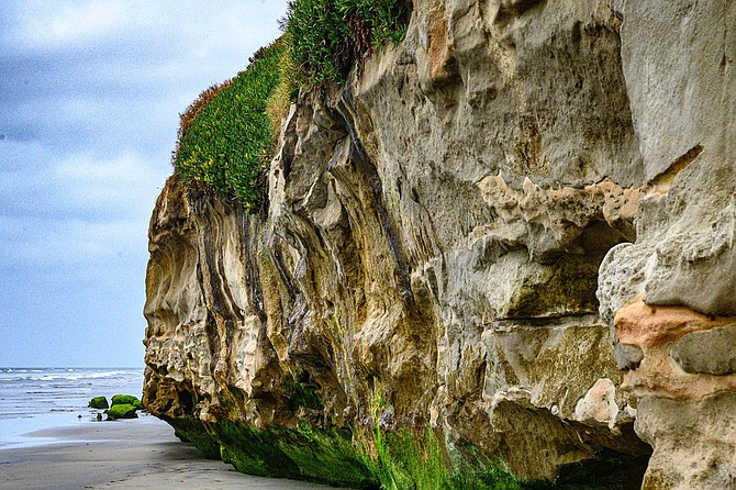
Terra Marr Cliff show the results of wave undercut
This beach hike extends from North Carlsbad Beach and Carlsbad State Beach to North Ponto Beach. Along the way, notice our natural beach ecology, especially the intertidal zone, its plants and wildlife, along with the impacts of human activities.
To reach the starting point, go down the stairs at the Rue des Chateaux Beach Access, and walk north toward Buena Vista Lagoon’s inlet to the sea, a distance of about 300 yards. Notice that the lagoon doesn’t have full access to the sea because it is blocked by a weir, a kind of dam, which holds the lagoon waters at a level 6 feet above mean high tide, thus preventing sand carried by Buena Vista Creek from reaching the beach, which causes erosion over time.
From the weir, start hiking south down the beach toward the Pine Avenue beach access point, a distance of 0.8 mile. Here, you come to an area where bluff erosion is a serious threat to Carlsbad Boulevard, which here runs along the top of the bluff. Native plants, including coast cholla, have been planted on the bluff to stabilize it and discourage foot traffic. In addition, a concrete seawall walkway has been built between two parallel seawalls at the bluff’s base, extending for about 0.8 mile between Pine Avenue and Tamarack.
Notice the “groomed” beach; the sand is regularly raked with machines to “clean” it, but the raking also removes natural beach wrack, an accumulation of driftwood, crabs, dead fish, kelp and other sea weeds washed onto the beach, homes to many living things.
Sandflies breed and live in these piles of kelp, providing food for birds such as black phoebes and other fly catchers. Decaying wrack also releases nutrients that help support the life of a wide variety of invertebrates that live in the intertidal zone.
Stay on the beach by walking in or just above the intertidal zone, where a wide variety of invertebrates live, including isopods, sand crabs, and clams, all invertebrates which also provide food for birds.
In the fall and winter, watch for flocks of small white birds, sanderlings or other sandpipers, chasing waves, looking for sand crabs and other animals that are uncovered by the rushing water. Larger fall and winter visitors include long-billed curlews, marbled godwits, and whimbrels, also feasting on these intertidal, sand-dwelling animals.
Gulls in general are the most successful group of shorebirds, largely because they are not highly specialized in their diet. In fact, they often benefit from interactions with humans. Herring gulls are more often seen at fast food restaurants and landfills than at the beach. A mixture of gull species is often found gathered together near the intertidal zone, sleeping or watching the sea. These may include the California gull, Bonaparte’s gull, Western gull, ring-billed gull, or Heermann’s gull, depending on the season.
After hiking about 1.7 miles, you arrive at Tamarack State Beach, part of the Carlsbad State Beach and a surfer’s favorite. Jetties flanking the Hedionda Lagoon inlet extend for several hundred feet into the sea. At this point, you must go up the stairs to Carlsbad Boulevard and use the highway bridge to cross the lagoon inlet.
Carlsbad Boulevard continues down a narrow, elevated sand spit separating the lagoon from the ocean. The seawall continues as a single wall along the highway, protecting it from blowing beach sand and from flooding during high tides and storm- driven waves. Once you cross the lagoon inlet, leave the highway and head back to the beach to continue hiking south near the intertidal area. There is more wrack on this beach because the state park does not groom it — and possibly as a result, more sea life.
At about 2 miles from the start of your hike, you arrive at the Cabrillo Power Plant outflow. A fence that blocks public access from two jetties and water outflow is also protecting bird-nesting sites, in particular the snowy plover, an endangered species which lays its eggs directly on the sand.
Resume your beach walk beyond the power plant outflow on the bluff. Here are remnants of coastal sage scrub, but the area is heavily eroded. As erosion has occurred, the sand below has washed away, and rocks have accumulated at the high tide line below the bluff. The further down this beach you go, the less likely you are to find a sandy beach, except at low tides.
At about 2.5 miles into your hike, houses begin to appear on the bluffs and the beach essentially disappears at high tide, with the waves breaking near or on the rocks. Depending on the tides at the time of your visit, you may not be able to go further without getting wet.
The mesa that rises up here is known as Terra Marr Point, and the beach below it, when it appears, is Terra Marr Beach, accessible at low tide. If you have timed your visit right, you can walk around Terra Mar Point on the intertidal beach with only wet feet. Low tide also reveals beds of red and green algae, as well as wrack, including fragments from the more deeply rooted Macrocystis, a brown alga. You also will see how the waves, which can hit the rocky cliffs with a force of nearly 6000 pounds per square inch, are undermining them.
If you have not timed you visit with the tides, go back up to Carlsbad Boulevard and continue south on the roadside trail for about a quarter of a mile.
You can get back down to the beach by using the Cerezo Beach access stairs if the tide has receded sufficiently, but at high tide the waves will crash directly into the cliff here and there is no beach. If the tide is high and you can’t hike the beach from here, take the trail south on top of the Cerezo bluffs.
If you are unable to continue your beach walk below the Cerezo bluffs due to high tide, you should consider hiking south on the trail beside Carlsbad Boulevard. This trail has great ocean views and some native coastal sage scrub vegetation. It also gives you a view of bluff erosion from above. At 4.25 miles from the hike’s start, you reach North Ponto Beach, the turnaround point for the hike.
We hope you have enjoyed reading the Roam-O-Rama columns over the past eight years written by the San Diego Natural History Museum Canyoneers. This is our last entry for the Reader. Come hike with us – every weekend September through June. Check the hike schedule: www.sdnat.org/canyoneers.
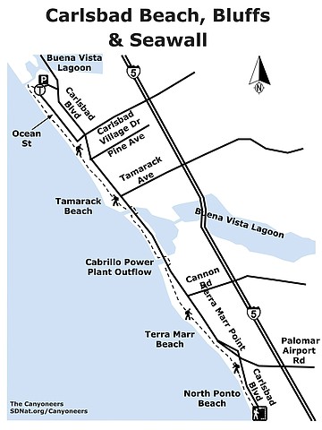
Carlsbad Beach, Bluffs & Seawall map
CARLSBAD BEACH, BLUFFS, & SEAWALL
Explore the worlds of the ocean intertidal zones.
- Driving directions: From downtown San Diego, take I-5 north about 36 miles to exit 50, Carlsbad Village Drive. Turn left onto Carlsbad Village Drive and go 0.8 mile. Turn right on Ocean Street and go 0.5 mile to Public Beach Access at 2445 Ocean Street. Hiking length: 4.25 miles one way, 8.5 miles round trip. Allow 2.5 -5.0 hours. 280 feet elevation gain/loss. Difficulty: Easy one-way and moderate round trip, relatively flat, sometimes wet. A tide table will be useful for timing your hike. Walkers, hikers, runners allowed. Sandy areas, road crossing. No dogs on the beach.
Here's something you might be interested in.
Hike Carlsbad Beach, bluffs, & seawall from Buena Vista Lagoon to North Ponto Beach
Explore the worlds of the ocean intertidal zones.
Hike Carlsbad Beach, bluffs, & seawall from Buena Vista Lagoon to North Ponto Beach
Explore the worlds of the ocean intertidal zones.
Terra Marr Cliff show the results of wave undercut
This beach hike extends from North Carlsbad Beach and Carlsbad State Beach to North Ponto Beach. Along the way, notice our natural beach ecology, especially the intertidal zone, its plants and wildlife, along with the impacts of human activities.
To reach the starting point, go down the stairs at the Rue des Chateaux Beach Access, and walk north toward Buena Vista Lagoon’s inlet to the sea, a distance of about 300 yards. Notice that the lagoon doesn’t have full access to the sea because it is blocked by a weir, a kind of dam, which holds the lagoon waters at a level 6 feet above mean high tide, thus preventing sand carried by Buena Vista Creek from reaching the beach, which causes erosion over time.
From the weir, start hiking south down the beach toward the Pine Avenue beach access point, a distance of 0.8 mile. Here, you come to an area where bluff erosion is a serious threat to Carlsbad Boulevard, which here runs along the top of the bluff. Native plants, including coast cholla, have been planted on the bluff to stabilize it and discourage foot traffic. In addition, a concrete seawall walkway has been built between two parallel seawalls at the bluff’s base, extending for about 0.8 mile between Pine Avenue and Tamarack.
Notice the “groomed” beach; the sand is regularly raked with machines to “clean” it, but the raking also removes natural beach wrack, an accumulation of driftwood, crabs, dead fish, kelp and other sea weeds washed onto the beach, homes to many living things.
Sandflies breed and live in these piles of kelp, providing food for birds such as black phoebes and other fly catchers. Decaying wrack also releases nutrients that help support the life of a wide variety of invertebrates that live in the intertidal zone.
Stay on the beach by walking in or just above the intertidal zone, where a wide variety of invertebrates live, including isopods, sand crabs, and clams, all invertebrates which also provide food for birds.
In the fall and winter, watch for flocks of small white birds, sanderlings or other sandpipers, chasing waves, looking for sand crabs and other animals that are uncovered by the rushing water. Larger fall and winter visitors include long-billed curlews, marbled godwits, and whimbrels, also feasting on these intertidal, sand-dwelling animals.
Gulls in general are the most successful group of shorebirds, largely because they are not highly specialized in their diet. In fact, they often benefit from interactions with humans. Herring gulls are more often seen at fast food restaurants and landfills than at the beach. A mixture of gull species is often found gathered together near the intertidal zone, sleeping or watching the sea. These may include the California gull, Bonaparte’s gull, Western gull, ring-billed gull, or Heermann’s gull, depending on the season.
After hiking about 1.7 miles, you arrive at Tamarack State Beach, part of the Carlsbad State Beach and a surfer’s favorite. Jetties flanking the Hedionda Lagoon inlet extend for several hundred feet into the sea. At this point, you must go up the stairs to Carlsbad Boulevard and use the highway bridge to cross the lagoon inlet.
Carlsbad Boulevard continues down a narrow, elevated sand spit separating the lagoon from the ocean. The seawall continues as a single wall along the highway, protecting it from blowing beach sand and from flooding during high tides and storm- driven waves. Once you cross the lagoon inlet, leave the highway and head back to the beach to continue hiking south near the intertidal area. There is more wrack on this beach because the state park does not groom it — and possibly as a result, more sea life.
At about 2 miles from the start of your hike, you arrive at the Cabrillo Power Plant outflow. A fence that blocks public access from two jetties and water outflow is also protecting bird-nesting sites, in particular the snowy plover, an endangered species which lays its eggs directly on the sand.
Resume your beach walk beyond the power plant outflow on the bluff. Here are remnants of coastal sage scrub, but the area is heavily eroded. As erosion has occurred, the sand below has washed away, and rocks have accumulated at the high tide line below the bluff. The further down this beach you go, the less likely you are to find a sandy beach, except at low tides.
At about 2.5 miles into your hike, houses begin to appear on the bluffs and the beach essentially disappears at high tide, with the waves breaking near or on the rocks. Depending on the tides at the time of your visit, you may not be able to go further without getting wet.
The mesa that rises up here is known as Terra Marr Point, and the beach below it, when it appears, is Terra Marr Beach, accessible at low tide. If you have timed your visit right, you can walk around Terra Mar Point on the intertidal beach with only wet feet. Low tide also reveals beds of red and green algae, as well as wrack, including fragments from the more deeply rooted Macrocystis, a brown alga. You also will see how the waves, which can hit the rocky cliffs with a force of nearly 6000 pounds per square inch, are undermining them.
If you have not timed you visit with the tides, go back up to Carlsbad Boulevard and continue south on the roadside trail for about a quarter of a mile.
You can get back down to the beach by using the Cerezo Beach access stairs if the tide has receded sufficiently, but at high tide the waves will crash directly into the cliff here and there is no beach. If the tide is high and you can’t hike the beach from here, take the trail south on top of the Cerezo bluffs.
If you are unable to continue your beach walk below the Cerezo bluffs due to high tide, you should consider hiking south on the trail beside Carlsbad Boulevard. This trail has great ocean views and some native coastal sage scrub vegetation. It also gives you a view of bluff erosion from above. At 4.25 miles from the hike’s start, you reach North Ponto Beach, the turnaround point for the hike.
We hope you have enjoyed reading the Roam-O-Rama columns over the past eight years written by the San Diego Natural History Museum Canyoneers. This is our last entry for the Reader. Come hike with us – every weekend September through June. Check the hike schedule: www.sdnat.org/canyoneers.
Carlsbad Beach, Bluffs & Seawall map
CARLSBAD BEACH, BLUFFS, & SEAWALL
Explore the worlds of the ocean intertidal zones.
- Driving directions: From downtown San Diego, take I-5 north about 36 miles to exit 50, Carlsbad Village Drive. Turn left onto Carlsbad Village Drive and go 0.8 mile. Turn right on Ocean Street and go 0.5 mile to Public Beach Access at 2445 Ocean Street. Hiking length: 4.25 miles one way, 8.5 miles round trip. Allow 2.5 -5.0 hours. 280 feet elevation gain/loss. Difficulty: Easy one-way and moderate round trip, relatively flat, sometimes wet. A tide table will be useful for timing your hike. Walkers, hikers, runners allowed. Sandy areas, road crossing. No dogs on the beach.