Here's something you might be interested in.
Ask a Hipster — Advice you didn't know you needed
Big Screen — Movie commentary
Blurt — Music's inside track
Booze News — San Diego spirits
Classical Music — Immortal beauty
Classifieds — Free and easy
Close to Home — What it’s like on the street where you live
Cover Stories — Front-page features
Drinks All Around — Bartenders' drink recipes
Excerpts — Literary and spiritual excerpts
Feast! — Food & drink reviews
Feature Stories — Local news & stories
Fishing Report — What’s getting hooked from ship and shore
From the Archives — Spotlight on the past
Golden Dreams — Talk of the town
The Gonzo Report — Making the musical scene, or at least reporting from it
Letters — Our inbox
Movies@Home — Local movie buffs share favorites
Movie Reviews — Our critics' picks and pans
Musician Interviews — Up close with local artists
Neighborhood News from Stringers — Hyperlocal news
News Ticker — News & politics
Obermeyer — San Diego politics illustrated
Outdoors — Weekly changes in flora and fauna
Overheard in San Diego — Eavesdropping illustrated
Poetry — The old and the new
Reader Travel — Travel section built by travelers
Reading — The hunt for intellectuals
Roam-O-Rama — SoCal's best hiking/biking trails
San Diego Beer — Inside San Diego suds
SD on the QT — Almost factual news
Sheep and Goats — Places of worship
Special Issues — The best of
Street Style — San Diego streets have style
Surf Diego — Real stories from those braving the waves
Theater — On stage in San Diego this week
Tin Fork — Silver spoon alternative
Under the Radar — Matt Potter's undercover work
Unforgettable — Long-ago San Diego
Unreal Estate — San Diego's priciest pads
Your Week — Daily event picks
Good hiking and beautiful vistas at Los Santos Trail Loop near Murrieta
Take this hike to view old California—rolling hills, oaks, wildflowers, and wildlife.
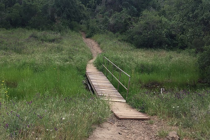
A bridge crossing in a pastoral setting
Santa Rosa Plateau Ecological Reserve, near Murrieta in Riverside County, consists of 9000 acres and many hiking trails. The one described here has good hiking with lots of beautiful vistas; wildlife such as birds, coyotes, rattlesnakes, and newts; rolling, grass-covered hills; sprawling oaks; and wildflowers. At certain times of the year, you can spot the snow-covered mountains of San Gorgonio and San Jacinto. Look also for coyotes walking through the landscape, or for their ropey scat on the trail. Listen for the beautiful song of the meadowlark.
Starting at the Vernal Pool Trailhead, walk 0.1 mile to the Los Santos Trail, go left (north), and continue for 1.2 miles. The trail is strewn with volcanic rocks, mariposa lilies, poppies, and prickly pear cacti. (Flowers are more likely in the spring.)The trail leads to oaks, bringing some shade. Watch for shade-loving poison oak as well. It is best to stay on the trail, and rest on benches that are available along the way. While sitting or walking, watch the tall grasses waving in the wind, and take in the California live oaks and Englemann oaks perched on the hillsides.
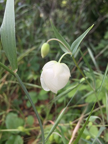
A globe lily in bloom on the trail
This is a great area to learn the differences between the California or coast live oak (Quercus agrifolia) and the Englemann oak (Quercus engelmannii). The live oak is a densely branched evergreen tree with prickly-edged, cupped leaves that are shiny, dark green above, and drab green and hairy below. The Englemann oak tree is less dense; the branches are artistically angular. Its leaves are flat blue-green ovals, with smooth edges. It is drought deciduous, meaning that in extended dry and hot conditions it drops leaves. The Reserve has one of the largest stands of these trees in its native southern California range. They grow best above the dry coastal plain and below 4,300 feet elevation.
After 1.0 mile, there is a steep rise covered with chamise (Adenostoma fasciculatum). This shrub, also called greasewood, is a keystone plant of the dense, woody chaparral ecosystem. As a keystone species, it has a disproportionately large effect on its environment; the chaparral ecosystem being dramatically changed when the species is removed. Its small bundled leaves and deep roots allow it to survive long periods of drought. It responds to fire by both resprouting from a burl and germinating seeds stimulated by chemicals in charred wood and smoke.
At mile 1.3, turn right (east) at the cutoff to Hidden Valley Road for 0.2 mile. Then turn left (north) onto Hidden Valley Road, walking for 0.7 mile. There you will see a sign for Coyote Trail (east), a beautiful trail with lots of oaks, sycamores, and a stream with a bridge crossing. It’s a good place to look for frogs and newts. In the spring, you will see lots of globe lilies, checkerblooms, purple vetch, popcorn flowers, and scrub oaks. This trail is only 0.5 mile long. When you come to a sign for Trans Preserve Trail, turn right. You will be passing a rise called Poppy Hill on the right. In spring, you will see plenty of poppies and large stands of lupine here.
After 0.9 mile on the Trans Preserve Trail, you will cross Ranch Road and continue on the trail up the hill (south) for 0.8 mile, toward more stands of oak trees. Take time to sit on the bench and enjoy more vistas of the area while listening for the ratcheting call of the acorn woodpecker, the trill of a spotted towhee. You might spot a soaring red-tailed hawk or hear the territorial call of a red-shouldered hawk. Next, there is a trail junction with Vernal Pool Trail. Turn right (west). The parking area where you started, which is just 0.5 mile away, will complete the loop.
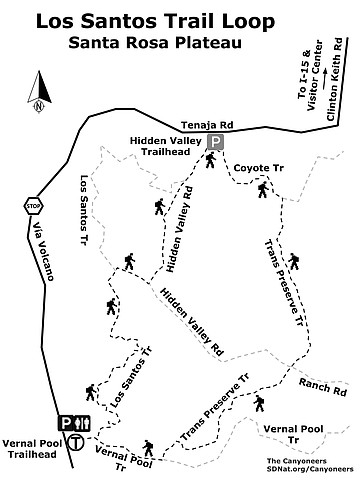
Los Santos Trail Loop map
- LOS SANTOS TRAIL LOOP (Santa Rosa Plateau)
- Take this hike to view old California—rolling hills, oaks, wildflowers, and wildlife.
- Driving directions: (Murrieta) From I-15 N toward Temecula, take the Clinton Keith Road exit and turn west (left). Drive 4.2 miles to the Santa Rosa Plateau Ecological Reserve Visitor Center on the left to visit exhibits, pick up a map, and to pay the day use fee of $4/person. Or, you can skip the visitor center and continue driving the 4 miles to the trailhead and pay the day use fee there. Take Clinton Keith Road for one mile past the visitor center. The road makes a sharp right and becomes Tenaja Road. Continue on Tenaja Road for 1.7 miles until you reach a stop sign. Tenaja Road turns right, but instead continue straight onto Via Volcano and go 0.8 mile until you see the sign for the Vernal Pool Trailhead. Park in the good-sized gravel parking lot. Hiking length: 5 miles out-and-back. Allow 2+ hours. Difficulty: Easy to moderate with a 488-foot elevation gain. Best time of year is March-May for wildflower viewing, but year-round use is possible and encouraged to see the preserve in all seasons. Watch for and avoid poison oak. The trails can be steep and rocky for short stretches. Trail signs are clear and easy to follow; pick up a map at the visitor center or online. Trails are closed after heavy rains.
Here's something you might be interested in.
Good hiking and beautiful vistas at Los Santos Trail Loop near Murrieta
Take this hike to view old California—rolling hills, oaks, wildflowers, and wildlife.
Good hiking and beautiful vistas at Los Santos Trail Loop near Murrieta
Take this hike to view old California—rolling hills, oaks, wildflowers, and wildlife.
A bridge crossing in a pastoral setting
Santa Rosa Plateau Ecological Reserve, near Murrieta in Riverside County, consists of 9000 acres and many hiking trails. The one described here has good hiking with lots of beautiful vistas; wildlife such as birds, coyotes, rattlesnakes, and newts; rolling, grass-covered hills; sprawling oaks; and wildflowers. At certain times of the year, you can spot the snow-covered mountains of San Gorgonio and San Jacinto. Look also for coyotes walking through the landscape, or for their ropey scat on the trail. Listen for the beautiful song of the meadowlark.
Starting at the Vernal Pool Trailhead, walk 0.1 mile to the Los Santos Trail, go left (north), and continue for 1.2 miles. The trail is strewn with volcanic rocks, mariposa lilies, poppies, and prickly pear cacti. (Flowers are more likely in the spring.)The trail leads to oaks, bringing some shade. Watch for shade-loving poison oak as well. It is best to stay on the trail, and rest on benches that are available along the way. While sitting or walking, watch the tall grasses waving in the wind, and take in the California live oaks and Englemann oaks perched on the hillsides.
A globe lily in bloom on the trail
This is a great area to learn the differences between the California or coast live oak (Quercus agrifolia) and the Englemann oak (Quercus engelmannii). The live oak is a densely branched evergreen tree with prickly-edged, cupped leaves that are shiny, dark green above, and drab green and hairy below. The Englemann oak tree is less dense; the branches are artistically angular. Its leaves are flat blue-green ovals, with smooth edges. It is drought deciduous, meaning that in extended dry and hot conditions it drops leaves. The Reserve has one of the largest stands of these trees in its native southern California range. They grow best above the dry coastal plain and below 4,300 feet elevation.
After 1.0 mile, there is a steep rise covered with chamise (Adenostoma fasciculatum). This shrub, also called greasewood, is a keystone plant of the dense, woody chaparral ecosystem. As a keystone species, it has a disproportionately large effect on its environment; the chaparral ecosystem being dramatically changed when the species is removed. Its small bundled leaves and deep roots allow it to survive long periods of drought. It responds to fire by both resprouting from a burl and germinating seeds stimulated by chemicals in charred wood and smoke.
At mile 1.3, turn right (east) at the cutoff to Hidden Valley Road for 0.2 mile. Then turn left (north) onto Hidden Valley Road, walking for 0.7 mile. There you will see a sign for Coyote Trail (east), a beautiful trail with lots of oaks, sycamores, and a stream with a bridge crossing. It’s a good place to look for frogs and newts. In the spring, you will see lots of globe lilies, checkerblooms, purple vetch, popcorn flowers, and scrub oaks. This trail is only 0.5 mile long. When you come to a sign for Trans Preserve Trail, turn right. You will be passing a rise called Poppy Hill on the right. In spring, you will see plenty of poppies and large stands of lupine here.
After 0.9 mile on the Trans Preserve Trail, you will cross Ranch Road and continue on the trail up the hill (south) for 0.8 mile, toward more stands of oak trees. Take time to sit on the bench and enjoy more vistas of the area while listening for the ratcheting call of the acorn woodpecker, the trill of a spotted towhee. You might spot a soaring red-tailed hawk or hear the territorial call of a red-shouldered hawk. Next, there is a trail junction with Vernal Pool Trail. Turn right (west). The parking area where you started, which is just 0.5 mile away, will complete the loop.
Los Santos Trail Loop map
- LOS SANTOS TRAIL LOOP (Santa Rosa Plateau)
- Take this hike to view old California—rolling hills, oaks, wildflowers, and wildlife.
- Driving directions: (Murrieta) From I-15 N toward Temecula, take the Clinton Keith Road exit and turn west (left). Drive 4.2 miles to the Santa Rosa Plateau Ecological Reserve Visitor Center on the left to visit exhibits, pick up a map, and to pay the day use fee of $4/person. Or, you can skip the visitor center and continue driving the 4 miles to the trailhead and pay the day use fee there. Take Clinton Keith Road for one mile past the visitor center. The road makes a sharp right and becomes Tenaja Road. Continue on Tenaja Road for 1.7 miles until you reach a stop sign. Tenaja Road turns right, but instead continue straight onto Via Volcano and go 0.8 mile until you see the sign for the Vernal Pool Trailhead. Park in the good-sized gravel parking lot. Hiking length: 5 miles out-and-back. Allow 2+ hours. Difficulty: Easy to moderate with a 488-foot elevation gain. Best time of year is March-May for wildflower viewing, but year-round use is possible and encouraged to see the preserve in all seasons. Watch for and avoid poison oak. The trails can be steep and rocky for short stretches. Trail signs are clear and easy to follow; pick up a map at the visitor center or online. Trails are closed after heavy rains.