Here's something you might be interested in.
Ask a Hipster — Advice you didn't know you needed
Big Screen — Movie commentary
Blurt — Music's inside track
Booze News — San Diego spirits
Classical Music — Immortal beauty
Classifieds — Free and easy
Close to Home — What it’s like on the street where you live
Cover Stories — Front-page features
Drinks All Around — Bartenders' drink recipes
Excerpts — Literary and spiritual excerpts
Feast! — Food & drink reviews
Feature Stories — Local news & stories
Fishing Report — What’s getting hooked from ship and shore
From the Archives — Spotlight on the past
Golden Dreams — Talk of the town
The Gonzo Report — Making the musical scene, or at least reporting from it
Letters — Our inbox
Movies@Home — Local movie buffs share favorites
Movie Reviews — Our critics' picks and pans
Musician Interviews — Up close with local artists
Neighborhood News from Stringers — Hyperlocal news
News Ticker — News & politics
Obermeyer — San Diego politics illustrated
Outdoors — Weekly changes in flora and fauna
Overheard in San Diego — Eavesdropping illustrated
Poetry — The old and the new
Reader Travel — Travel section built by travelers
Reading — The hunt for intellectuals
Roam-O-Rama — SoCal's best hiking/biking trails
San Diego Beer — Inside San Diego suds
SD on the QT — Almost factual news
Sheep and Goats — Places of worship
Special Issues — The best of
Street Style — San Diego streets have style
Surf Diego — Real stories from those braving the waves
Theater — On stage in San Diego this week
Tin Fork — Silver spoon alternative
Under the Radar — Matt Potter's undercover work
Unforgettable — Long-ago San Diego
Unreal Estate — San Diego's priciest pads
Your Week — Daily event picks
No-man's land in San Ysidro to get trees
Bandits made San Diego cops leave
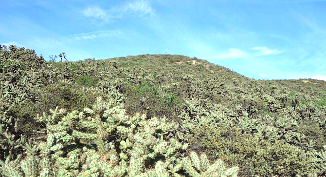
The land for the park is part of a large, rough area of ridges and canyons.
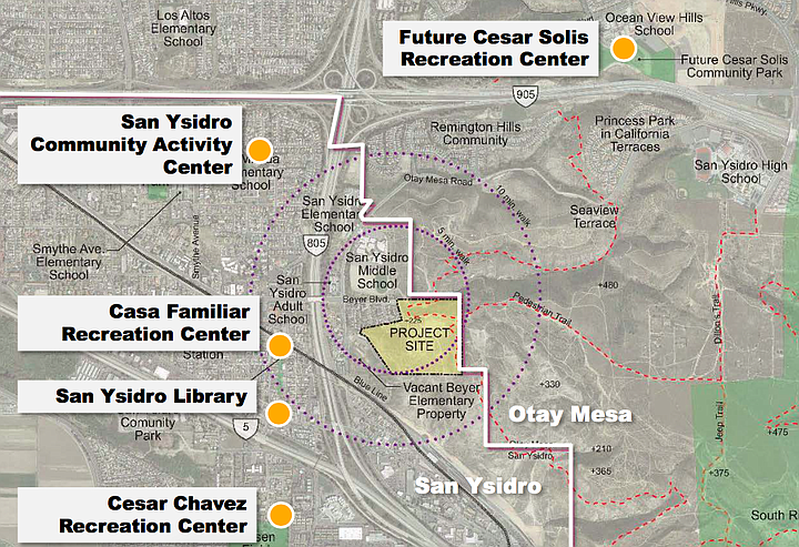
Although the hoped-for park in San Ysidro has gotten smaller, the plan for a piece of land at the end of Beyer Boulevard is now sharpened to a fine point.
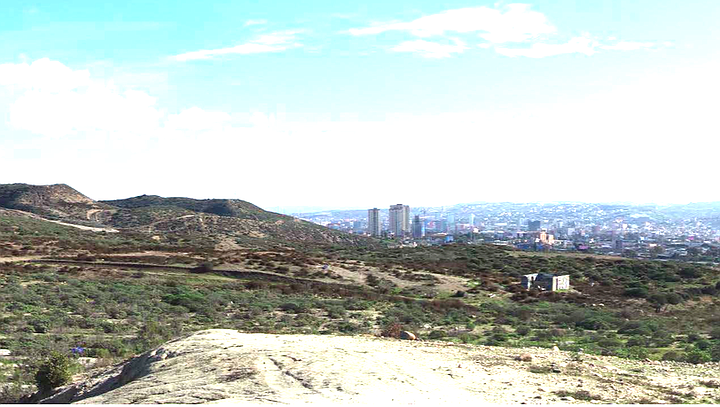
The site sits high in the hills with spectacular views of Tijuana.
Monday night, planning group members expressed disappointment that they can’t fit a baseball field onto the eight-acre site that sits high in the hills with spectacular views of Tijuana, an earthquake fault and a landslide zone at the south end.
In the 2007 plan, the San Ysidro and Otay Mesa neighborhoods were going to share the park, but Otay Mesa is no longer involved.
In 2007, the first presentation showed a 12.5-acre park, not eight acres. “We had more features in that area where we lost two acres, “said San Ysidro resident Alberto Perez. “I understand about the two acres (with endangered species on them) but I don’t understand about the other two acres.”
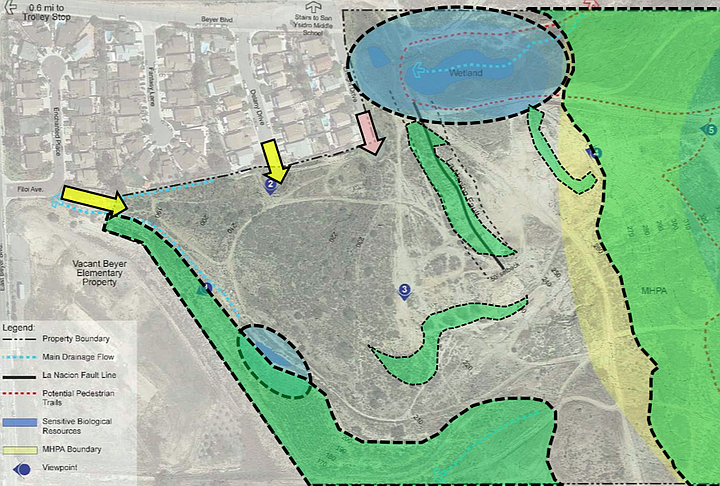
The size of the park is restricted by a wetlands habitat to the northeast, and a coastal sage habitat to the east.
The size of the park on city-owned land is restricted by a wetlands habitat to the northeast, and a coastal sage habitat to the east that is home to two endangered bird species, the least bell’s vireo and the California gnatcatcher, according to project manager Darren Genova. Genova, like most city employees is not allowed to speak to reporters but he gave a presentation at the San Ysidro Planning Group Monday night.
Planners have spent about $400,000 on environmental reports, geotechnical reports and design. But they don’t have the $17 million they need to actually build the park.
The land is east of the 805, less than a mile from where it merges with the 5 at the border. It’s part of a large, rough area of ridges and canyons that were never developed — the eastern edge of the open space is the industrial area of Otay Mesa and, to the north, trails head south from San Ysidro High School into the no-man’s-land. The parcel stretches almost three miles across and 1.5 miles from Otay Mesa Road to the U.S.-Mexico border.
The canyons here became notorious in the 1970s, 1980s and 1990s for the bandits who stripped migrants entering the U.S. of their belongings. San Diego police and the Border Patrol used to team up in undercover operations to catch the bandits, an enforcement effort that was suspended after several San Diego cops were shot in gunfights, at least once the bandits turned out to be police from Tijuana. San Diego lawmen arrested more than 300 suspects for robberies, rapes and murders by the time it was suspended for good. Another group arrested: San Diego young guys who came to harass illegal border crossers.
It was slated for development in the 1990s, but developers discovered an earthquake fault running through the land north to south and abandoned the project. Much of the area — especially to the east toward Otay — remains a no-man’s land where people do things they shouldn’t; ATVs and dirt bikes race around and people dump trash, appliances and cars.
Above all this sits a plot of land that’s been set aside for more than a decade for a destination park.
In the 2007 plan, the San Ysidro and Otay Mesa neighborhoods were going to share the park, but Otay Mesa is no longer involved.
The city went back to work on the park in 2017 with a series of community meetings to see what people wanted and gathered a list that includes a soccer field, picnic and barbecue areas, an amphitheater, a basketball court, a skate park, dog off-leash area, exercise stations, children’s play areas and restrooms.
They’ve added a perimeter trail, plenty of shade structures and quiet places to sit. The plan calls for trees, lots of trees. They’d like to add slides to the steep landslide area. The park will be at the end of two residential streets that will be connected by the parking lot and entrance.
In 2007, Genova noted, the plan presented was a very early plan where they hadn’t talked to the agencies and land managers about the limits caused by endangered species and the problems of building in a landslide zone. This time, the city team is working with the wildlife agencies and land managers, and has obtained geological reports before they drew the plans. That information limits the park size, he said.
Perez was interested in the size of the trees that will be planted – most will be young trees eight to 10 feet tall.
“So that means I waited 34 years to see this get started and I’m going to wait another 30 years to sit in the shade from the park’s trees,” Perez said.
Here's something you might be interested in.
No-man's land in San Ysidro to get trees
Bandits made San Diego cops leave
No-man's land in San Ysidro to get trees
Bandits made San Diego cops leave
The land for the park is part of a large, rough area of ridges and canyons.
Although the hoped-for park in San Ysidro has gotten smaller, the plan for a piece of land at the end of Beyer Boulevard is now sharpened to a fine point.
The site sits high in the hills with spectacular views of Tijuana.
Monday night, planning group members expressed disappointment that they can’t fit a baseball field onto the eight-acre site that sits high in the hills with spectacular views of Tijuana, an earthquake fault and a landslide zone at the south end.
In the 2007 plan, the San Ysidro and Otay Mesa neighborhoods were going to share the park, but Otay Mesa is no longer involved.
In 2007, the first presentation showed a 12.5-acre park, not eight acres. “We had more features in that area where we lost two acres, “said San Ysidro resident Alberto Perez. “I understand about the two acres (with endangered species on them) but I don’t understand about the other two acres.”
The size of the park is restricted by a wetlands habitat to the northeast, and a coastal sage habitat to the east.
The size of the park on city-owned land is restricted by a wetlands habitat to the northeast, and a coastal sage habitat to the east that is home to two endangered bird species, the least bell’s vireo and the California gnatcatcher, according to project manager Darren Genova. Genova, like most city employees is not allowed to speak to reporters but he gave a presentation at the San Ysidro Planning Group Monday night.
Planners have spent about $400,000 on environmental reports, geotechnical reports and design. But they don’t have the $17 million they need to actually build the park.
The land is east of the 805, less than a mile from where it merges with the 5 at the border. It’s part of a large, rough area of ridges and canyons that were never developed — the eastern edge of the open space is the industrial area of Otay Mesa and, to the north, trails head south from San Ysidro High School into the no-man’s-land. The parcel stretches almost three miles across and 1.5 miles from Otay Mesa Road to the U.S.-Mexico border.
The canyons here became notorious in the 1970s, 1980s and 1990s for the bandits who stripped migrants entering the U.S. of their belongings. San Diego police and the Border Patrol used to team up in undercover operations to catch the bandits, an enforcement effort that was suspended after several San Diego cops were shot in gunfights, at least once the bandits turned out to be police from Tijuana. San Diego lawmen arrested more than 300 suspects for robberies, rapes and murders by the time it was suspended for good. Another group arrested: San Diego young guys who came to harass illegal border crossers.
It was slated for development in the 1990s, but developers discovered an earthquake fault running through the land north to south and abandoned the project. Much of the area — especially to the east toward Otay — remains a no-man’s land where people do things they shouldn’t; ATVs and dirt bikes race around and people dump trash, appliances and cars.
Above all this sits a plot of land that’s been set aside for more than a decade for a destination park.
In the 2007 plan, the San Ysidro and Otay Mesa neighborhoods were going to share the park, but Otay Mesa is no longer involved.
The city went back to work on the park in 2017 with a series of community meetings to see what people wanted and gathered a list that includes a soccer field, picnic and barbecue areas, an amphitheater, a basketball court, a skate park, dog off-leash area, exercise stations, children’s play areas and restrooms.
They’ve added a perimeter trail, plenty of shade structures and quiet places to sit. The plan calls for trees, lots of trees. They’d like to add slides to the steep landslide area. The park will be at the end of two residential streets that will be connected by the parking lot and entrance.
In 2007, Genova noted, the plan presented was a very early plan where they hadn’t talked to the agencies and land managers about the limits caused by endangered species and the problems of building in a landslide zone. This time, the city team is working with the wildlife agencies and land managers, and has obtained geological reports before they drew the plans. That information limits the park size, he said.
Perez was interested in the size of the trees that will be planted – most will be young trees eight to 10 feet tall.
“So that means I waited 34 years to see this get started and I’m going to wait another 30 years to sit in the shade from the park’s trees,” Perez said.
Comments