Here's something you might be interested in.
Ask a Hipster — Advice you didn't know you needed
Big Screen — Movie commentary
Blurt — Music's inside track
Booze News — San Diego spirits
Classical Music — Immortal beauty
Classifieds — Free and easy
Close to Home — What it’s like on the street where you live
Cover Stories — Front-page features
Drinks All Around — Bartenders' drink recipes
Excerpts — Literary and spiritual excerpts
Feast! — Food & drink reviews
Feature Stories — Local news & stories
Fishing Report — What’s getting hooked from ship and shore
From the Archives — Spotlight on the past
Golden Dreams — Talk of the town
The Gonzo Report — Making the musical scene, or at least reporting from it
Letters — Our inbox
Movies@Home — Local movie buffs share favorites
Movie Reviews — Our critics' picks and pans
Musician Interviews — Up close with local artists
Neighborhood News from Stringers — Hyperlocal news
News Ticker — News & politics
Obermeyer — San Diego politics illustrated
Outdoors — Weekly changes in flora and fauna
Overheard in San Diego — Eavesdropping illustrated
Poetry — The old and the new
Reader Travel — Travel section built by travelers
Reading — The hunt for intellectuals
Roam-O-Rama — SoCal's best hiking/biking trails
San Diego Beer — Inside San Diego suds
SD on the QT — Almost factual news
Sheep and Goats — Places of worship
Special Issues — The best of
Street Style — San Diego streets have style
Surf Diego — Real stories from those braving the waves
Theater — On stage in San Diego this week
Tin Fork — Silver spoon alternative
Under the Radar — Matt Potter's undercover work
Unforgettable — Long-ago San Diego
Unreal Estate — San Diego's priciest pads
Your Week — Daily event picks
Twenty miles of bike trails for Pamo Valley
What the Forest Service came up with
Orozco Ridge will rival the terrain of Snow Summit and Mammoth.
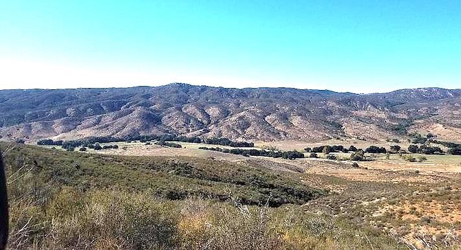
The Pamo Valley is situated to the north of Ramona. It is part of the Palomar Ranger District of the Cleveland National Forest. The region is bookended by Lake Sutherland to the east, and Rancho Guejito to the west. It’s a sprawling expanse of land that is unknown to most San Diegans.
About half the trails will have to be accessible by horses.
The Orosco Ridge is part of this region. In the past, one portion of the remote area was often used by local gun enthusiasts as a firing range. Besides that and some hiking and equestrian access, it’s a pretty quiet, desolate area. It currently has a handful of truck roads visitors can use to explore the property. This may change very soon, and in a big way. If the San Diego Mountain Bike Association gets its wishes, construction will begin on 20 miles of brand new singletrack trails that will be open to bikers, hikers and equestrians by the end of this year. It will easily be the largest singletrack trail system in the region, and will rival California resort parks such as Snow Summit and Mammoth for quality of terrain.
“We went to the Forest Service with a number of different concepts and they weren’t too hot on what we were proposing in other areas," San Diego Mountain Bike Association vice president Ben Stone said. “We said, ‘All right, where should we look at expanding recreation on this district?’ This was the general area they came back with. That’s based on the way the forest was zoned within their own land-use plan. This area was sort-of zoned as backcountry non-motorized, and some of it is a little motorized.”
When you look at the proposed trail system on a map, it closely resembles the appearance of a ski resort — the only difference being the absence of traditional ski lifts. The majority of the downhill trails will begin near the Drasco Truck Trail, and descend east from, depending on the trail, about 500-700 feet. The Drasco Truck Trail will serve as a connecting point at the peak of the area, while a series of uphill or two-way trails will encircle the downhill trails so visitors have an easier route back to the top — with less-likelihood of collision as well. The trail directions will be open to interpretation though as, according to Stone, “It’s all a suggestion under the Forest Service rules.”
“We’re gonna have a lot of signage out there like ‘This is one-way’ but, at the end of the day, it’s not really enforceable. It’s all sort of a suggestion. We’re borrowing from other areas in the state and country where it has worked,” Stone added.
Stone stressed that everything they build will be “100% singletrack” that will be between two to four feet wide. About half the trails will have to be accessible by horses, so these routes will include less of the bike-specific features (drop-offs/banked turns) and will be built to control people’s speed while descending.
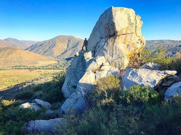
“The directional trails will be more purpose-built for mountain biking. There will be some natural rock drop-offs. There are some huge boulders that are the size of houses out there, and you can incorporate them into the trail system. There will be varying degrees of difficulty that will manage what the design will look like but, really, there’s going to be something for everyone out there—whether you’re looking for an intermediate sort of ‘flow trail’ that keeps your momentum going naturally to something that really needs to be traversed by a pretty skilled rider,” Stone said.
One local that is excited about the potential of this project is Joe Stupar, executive director of the Ramona Chamber of Commerce. He realizes the bump the local business district could absorb, and has personal experience riding in the Orosco Ridge area.
“It’s pretty rugged terrain. I’ve been out there. I have horses. It’s not all flat. There’s up and down, rocks and all kinds of stuff. It makes it challenging,” he said.
Via email, Joey Martin, assistant recreation officer for the Palomar Ranger District, said this project “has the potential to bring a large user group to the historical community of Ramona, of which the Palomar Ranger District is centered in and a member of. The Palomar Ranger District of the Cleveland National Forest is proud to already have the support of local elected officials and non-profit organizations that have a stake in this area.”
The mountain bike association is about $70,000 in on this project so far, and all of that money has gone towards design concept, ground-truthing, and forest service staff time. Besides money, two other large hurdles remain before trails can be blazed.
“We have to follow the National Environmental Policy Act. So, all the specialists from the forest service have to review our trail corridor for sensitive resources—botany, plants, animal species, even small birds and reptiles. Anything that is federally listed or endangered. We don’t want to disrupt any species that is out here. Cultural as well. Any archeology we want to avoid. As the specialists survey this area they will make recommendations on things we need to avoid or modifications we need to make to the trail system. That’s really all that remains. Once they finish their surveys they will make recommendations to the district ranger, and then the district ranger will get to decide if they want to move forward on the project or not,” Stone said.
One last twist to this story is that the Palomar Ranger District currently has an interim ranger. A new, permanent, ranger will be hired in three to four months and will likely get the final say as to whether or not this project lives or dies. If it does move forward, the entire trail system has the potential to be completed within a year.
“A good machine operator can build 500 feet [of trail] in a day. So that’s one-tenth of a mile a day. So, ten days is one mile—two weeks a mile. If we’re just throwing out random numbers, forty weeks to build 20 miles. It will all depend on how much funding we get. We’ve been building a couple miles a year in Black Mountain these last couple of years for the city of San Diego. We’ve had no financial support and it’s all been hand-built by volunteers,” Stone said.
Here's something you might be interested in.
Twenty miles of bike trails for Pamo Valley
What the Forest Service came up with
Twenty miles of bike trails for Pamo Valley
What the Forest Service came up with
Orozco Ridge will rival the terrain of Snow Summit and Mammoth.
The Pamo Valley is situated to the north of Ramona. It is part of the Palomar Ranger District of the Cleveland National Forest. The region is bookended by Lake Sutherland to the east, and Rancho Guejito to the west. It’s a sprawling expanse of land that is unknown to most San Diegans.
About half the trails will have to be accessible by horses.
The Orosco Ridge is part of this region. In the past, one portion of the remote area was often used by local gun enthusiasts as a firing range. Besides that and some hiking and equestrian access, it’s a pretty quiet, desolate area. It currently has a handful of truck roads visitors can use to explore the property. This may change very soon, and in a big way. If the San Diego Mountain Bike Association gets its wishes, construction will begin on 20 miles of brand new singletrack trails that will be open to bikers, hikers and equestrians by the end of this year. It will easily be the largest singletrack trail system in the region, and will rival California resort parks such as Snow Summit and Mammoth for quality of terrain.
“We went to the Forest Service with a number of different concepts and they weren’t too hot on what we were proposing in other areas," San Diego Mountain Bike Association vice president Ben Stone said. “We said, ‘All right, where should we look at expanding recreation on this district?’ This was the general area they came back with. That’s based on the way the forest was zoned within their own land-use plan. This area was sort-of zoned as backcountry non-motorized, and some of it is a little motorized.”
When you look at the proposed trail system on a map, it closely resembles the appearance of a ski resort — the only difference being the absence of traditional ski lifts. The majority of the downhill trails will begin near the Drasco Truck Trail, and descend east from, depending on the trail, about 500-700 feet. The Drasco Truck Trail will serve as a connecting point at the peak of the area, while a series of uphill or two-way trails will encircle the downhill trails so visitors have an easier route back to the top — with less-likelihood of collision as well. The trail directions will be open to interpretation though as, according to Stone, “It’s all a suggestion under the Forest Service rules.”
“We’re gonna have a lot of signage out there like ‘This is one-way’ but, at the end of the day, it’s not really enforceable. It’s all sort of a suggestion. We’re borrowing from other areas in the state and country where it has worked,” Stone added.
Stone stressed that everything they build will be “100% singletrack” that will be between two to four feet wide. About half the trails will have to be accessible by horses, so these routes will include less of the bike-specific features (drop-offs/banked turns) and will be built to control people’s speed while descending.
“The directional trails will be more purpose-built for mountain biking. There will be some natural rock drop-offs. There are some huge boulders that are the size of houses out there, and you can incorporate them into the trail system. There will be varying degrees of difficulty that will manage what the design will look like but, really, there’s going to be something for everyone out there—whether you’re looking for an intermediate sort of ‘flow trail’ that keeps your momentum going naturally to something that really needs to be traversed by a pretty skilled rider,” Stone said.
One local that is excited about the potential of this project is Joe Stupar, executive director of the Ramona Chamber of Commerce. He realizes the bump the local business district could absorb, and has personal experience riding in the Orosco Ridge area.
“It’s pretty rugged terrain. I’ve been out there. I have horses. It’s not all flat. There’s up and down, rocks and all kinds of stuff. It makes it challenging,” he said.
Via email, Joey Martin, assistant recreation officer for the Palomar Ranger District, said this project “has the potential to bring a large user group to the historical community of Ramona, of which the Palomar Ranger District is centered in and a member of. The Palomar Ranger District of the Cleveland National Forest is proud to already have the support of local elected officials and non-profit organizations that have a stake in this area.”
The mountain bike association is about $70,000 in on this project so far, and all of that money has gone towards design concept, ground-truthing, and forest service staff time. Besides money, two other large hurdles remain before trails can be blazed.
“We have to follow the National Environmental Policy Act. So, all the specialists from the forest service have to review our trail corridor for sensitive resources—botany, plants, animal species, even small birds and reptiles. Anything that is federally listed or endangered. We don’t want to disrupt any species that is out here. Cultural as well. Any archeology we want to avoid. As the specialists survey this area they will make recommendations on things we need to avoid or modifications we need to make to the trail system. That’s really all that remains. Once they finish their surveys they will make recommendations to the district ranger, and then the district ranger will get to decide if they want to move forward on the project or not,” Stone said.
One last twist to this story is that the Palomar Ranger District currently has an interim ranger. A new, permanent, ranger will be hired in three to four months and will likely get the final say as to whether or not this project lives or dies. If it does move forward, the entire trail system has the potential to be completed within a year.
“A good machine operator can build 500 feet [of trail] in a day. So that’s one-tenth of a mile a day. So, ten days is one mile—two weeks a mile. If we’re just throwing out random numbers, forty weeks to build 20 miles. It will all depend on how much funding we get. We’ve been building a couple miles a year in Black Mountain these last couple of years for the city of San Diego. We’ve had no financial support and it’s all been hand-built by volunteers,” Stone said.
Comments