Here's something you might be interested in.
Ask a Hipster — Advice you didn't know you needed
Big Screen — Movie commentary
Blurt — Music's inside track
Booze News — San Diego spirits
Classical Music — Immortal beauty
Classifieds — Free and easy
Close to Home — What it’s like on the street where you live
Cover Stories — Front-page features
Drinks All Around — Bartenders' drink recipes
Excerpts — Literary and spiritual excerpts
Feast! — Food & drink reviews
Feature Stories — Local news & stories
Fishing Report — What’s getting hooked from ship and shore
From the Archives — Spotlight on the past
Golden Dreams — Talk of the town
The Gonzo Report — Making the musical scene, or at least reporting from it
Letters — Our inbox
Movies@Home — Local movie buffs share favorites
Movie Reviews — Our critics' picks and pans
Musician Interviews — Up close with local artists
Neighborhood News from Stringers — Hyperlocal news
News Ticker — News & politics
Obermeyer — San Diego politics illustrated
Outdoors — Weekly changes in flora and fauna
Overheard in San Diego — Eavesdropping illustrated
Poetry — The old and the new
Reader Travel — Travel section built by travelers
Reading — The hunt for intellectuals
Roam-O-Rama — SoCal's best hiking/biking trails
San Diego Beer — Inside San Diego suds
SD on the QT — Almost factual news
Sheep and Goats — Places of worship
Special Issues — The best of
Street Style — San Diego streets have style
Surf Diego — Real stories from those braving the waves
Theater — On stage in San Diego this week
Tin Fork — Silver spoon alternative
Under the Radar — Matt Potter's undercover work
Unforgettable — Long-ago San Diego
Unreal Estate — San Diego's priciest pads
Your Week — Daily event picks
Del Mar Mesa Preserve
This hike explores rare vernal pools
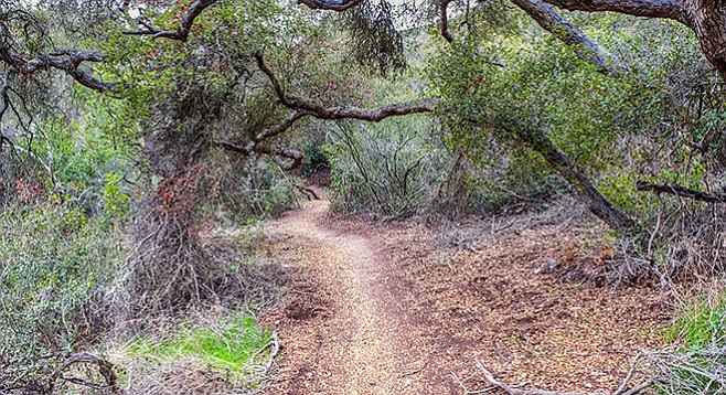
Del Mar Mesa Preserve—trees shade the trail
The Del Mar Mesa is a flat, chaparral-covered plateau, with an average elevation of 400 feet above sea level. Canyons drain south from the plateau into Los Peñasquitos Creek and northwest into Deer Creek, then into Carmel Valley. The flat mesa is home to numerous vernal pools. Those on land controlled by the California Department of Fish and Wildlife are currently off limits to casual visitors, but you will see some damaged pools on lands controlled by other agencies on this hike. Vernal pools have special ecology, making them worth preserving. They are homes for plants and animals that have evolved for the unique environmental conditions these pools provide, some of which cannot be found elsewhere in nature. The organisms that make their homes here must cope with standing water for at most a few months, then dry, hard sunbaked soil for the rest of the year. They live in a highly endangered habitat. At the present time, 97% of the vernal pools in Southern California have been destroyed to provide level ground for agriculture or building sites for homes, factories, or other buildings.
The canyons of the Preserve offer a most intriguing spectacle. Many contain chaparral with no evidence of past fire. Here typical chaparral species, especially scrub oak (Quercus berberidifolia), but also lemonadeberry (Rhus integrifolia), mountain mahogany (Cercocarpus betuloides) and mission manzanita (Xylococcus bicolor) have grown into small trees, with spreading canopies, creating an enchanting miniature forest you can easily walk under. Locally, the trails through these are designated tunnels and provide cooling shade on hot days. This hike will take you through Tunnel 4 and down to Deer Creek, where you may find a shallow stream.
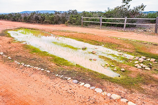
Rocks surround a damaged vernal pool.
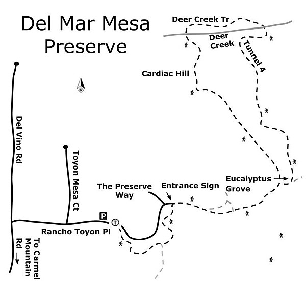
From the trailhead, the first half-mile of trail circumnavigates a small housing development, ironically named “The Preserve.” Instead of preserving nature, it has destroyed what was adapted to the soil and climate of the mesa to create a haven from nature. However, the developers also constructed an easily traversed gravel trail around it. As you progress around the development, you will come to trails branching off to the right that would, if you followed them, take you down through canyons to the Los Peñasquitos Preserve. Keep left. Soon after turning east and traveling away from the development on a wide dirt road, you will see a large sign ahead for the Del Mar Mesa Preserve, and just beyond it, a grove of eucalyptus trees at what may have been an old homestead site. Within 0.01 mile of the sign, the fire road splits. Take the road to the right. Shortly, you will come to a four-way intersection. The fire road continues across the mesa while the Bowtie trail splits off to the left and has a sign asking you not to enter, though hundreds of mountain bikers make regular use of this trail. On the right is another marker that simply announces ”Trail.” Continue on the trail to the right toward the eucalyptus grove, which you will reach at about 0.9 mile from the trailhead.
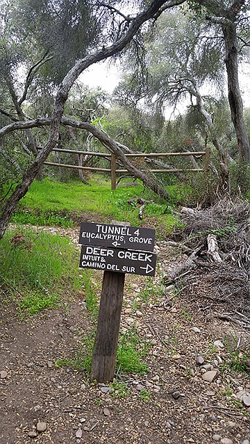
Trail is well marked.
Up to this point you have been traveling along the mesa top through coastal or maritime chaparral, dominated by chamise, with an intermixture of lemonadeberry, mission manzanitas, black sage, spine brush, coast prickly pear, spice bush, common fiddlenecks, and bush monkeyflower. Although the Preserve rules admonish you to stay on the designated trails, if you were to try to walk through these brushlands, you would find it very difficult due to the thick growth of stiff shrub branches, often armed with thorns that would tear at your clothes and flesh. Openings between shrubs are usually small and might contain a cryptogamic crust composed of drought-resistant moss, lichens, and other non-flowering plants, or represent depressions containing vernal pools.
The mesa chaparral rarely rises above waist or shoulder height and doesn’t prepare you for what you find when you enter the canyon chaparral, such as you’ll find on the Tunnel 4 Trail, which starts shortly beyond the eucalyptus grove. Not only has the chaparral grown to a height well over your head, but also the dominant species are scrub oak and lemonadeberry, with only a few spindly chamise and black sage. Tunnel 4 Trail continues down the canyon through this enchanting forest for nearly a mile before connecting with Deer Creek. After crossing Deer Creek, follow the trail above the creek heading west until you reach the Fire Road going south. It crosses Deer Creek again, and then proceeds up a hillside named “Cardiac Hill,” though it is neither very steep nor very difficult. Follow the Fire Road back toward the eucalyptus grove, then continue on the path around the housing development to your vehicle.
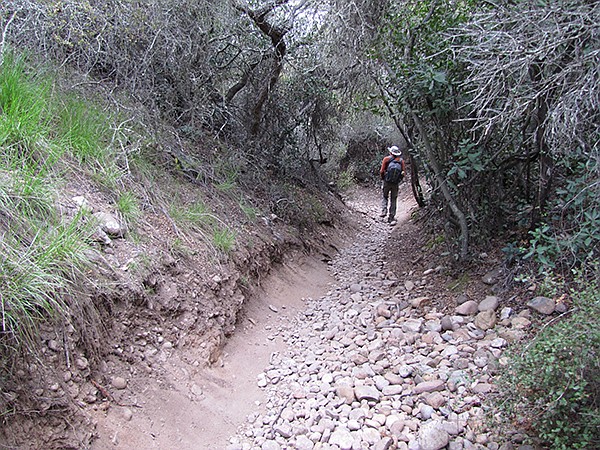
Trees shade the trail.
Driving directions: (Del Mar) From downtown San Diego, take I-5 north to Del Mar. Stay in the right lane as you approach the I-5/I-805 merge and get on the I-5 Local Bypass road. Exit the I-5 Bypass road onto Carmel Mountain Road. Follow Carmel Mountain Road east through one signal, turning right at the next. Continue on Carmel Mountain Road for about 5 miles. Its name changes to Del Vino Road after crossing a bridge where the road narrows. Continue on Del Vino until you reach Rancho Toyon Place, on your right. Proceed down Rancho Toyon Place to the trailhead, on the right, just before a gated community. Park on the public street before entering the turn around.
Hiking length: 4.5 miles, out-and-back. Allow 2.5 hours hiking time.
Difficulty: Moderate, with elevation gain 400 feet.
Here's something you might be interested in.
Del Mar Mesa Preserve
This hike explores rare vernal pools
Del Mar Mesa Preserve
This hike explores rare vernal pools
Del Mar Mesa Preserve—trees shade the trail
The Del Mar Mesa is a flat, chaparral-covered plateau, with an average elevation of 400 feet above sea level. Canyons drain south from the plateau into Los Peñasquitos Creek and northwest into Deer Creek, then into Carmel Valley. The flat mesa is home to numerous vernal pools. Those on land controlled by the California Department of Fish and Wildlife are currently off limits to casual visitors, but you will see some damaged pools on lands controlled by other agencies on this hike. Vernal pools have special ecology, making them worth preserving. They are homes for plants and animals that have evolved for the unique environmental conditions these pools provide, some of which cannot be found elsewhere in nature. The organisms that make their homes here must cope with standing water for at most a few months, then dry, hard sunbaked soil for the rest of the year. They live in a highly endangered habitat. At the present time, 97% of the vernal pools in Southern California have been destroyed to provide level ground for agriculture or building sites for homes, factories, or other buildings.
The canyons of the Preserve offer a most intriguing spectacle. Many contain chaparral with no evidence of past fire. Here typical chaparral species, especially scrub oak (Quercus berberidifolia), but also lemonadeberry (Rhus integrifolia), mountain mahogany (Cercocarpus betuloides) and mission manzanita (Xylococcus bicolor) have grown into small trees, with spreading canopies, creating an enchanting miniature forest you can easily walk under. Locally, the trails through these are designated tunnels and provide cooling shade on hot days. This hike will take you through Tunnel 4 and down to Deer Creek, where you may find a shallow stream.
Rocks surround a damaged vernal pool.
From the trailhead, the first half-mile of trail circumnavigates a small housing development, ironically named “The Preserve.” Instead of preserving nature, it has destroyed what was adapted to the soil and climate of the mesa to create a haven from nature. However, the developers also constructed an easily traversed gravel trail around it. As you progress around the development, you will come to trails branching off to the right that would, if you followed them, take you down through canyons to the Los Peñasquitos Preserve. Keep left. Soon after turning east and traveling away from the development on a wide dirt road, you will see a large sign ahead for the Del Mar Mesa Preserve, and just beyond it, a grove of eucalyptus trees at what may have been an old homestead site. Within 0.01 mile of the sign, the fire road splits. Take the road to the right. Shortly, you will come to a four-way intersection. The fire road continues across the mesa while the Bowtie trail splits off to the left and has a sign asking you not to enter, though hundreds of mountain bikers make regular use of this trail. On the right is another marker that simply announces ”Trail.” Continue on the trail to the right toward the eucalyptus grove, which you will reach at about 0.9 mile from the trailhead.
Trail is well marked.
Up to this point you have been traveling along the mesa top through coastal or maritime chaparral, dominated by chamise, with an intermixture of lemonadeberry, mission manzanitas, black sage, spine brush, coast prickly pear, spice bush, common fiddlenecks, and bush monkeyflower. Although the Preserve rules admonish you to stay on the designated trails, if you were to try to walk through these brushlands, you would find it very difficult due to the thick growth of stiff shrub branches, often armed with thorns that would tear at your clothes and flesh. Openings between shrubs are usually small and might contain a cryptogamic crust composed of drought-resistant moss, lichens, and other non-flowering plants, or represent depressions containing vernal pools.
The mesa chaparral rarely rises above waist or shoulder height and doesn’t prepare you for what you find when you enter the canyon chaparral, such as you’ll find on the Tunnel 4 Trail, which starts shortly beyond the eucalyptus grove. Not only has the chaparral grown to a height well over your head, but also the dominant species are scrub oak and lemonadeberry, with only a few spindly chamise and black sage. Tunnel 4 Trail continues down the canyon through this enchanting forest for nearly a mile before connecting with Deer Creek. After crossing Deer Creek, follow the trail above the creek heading west until you reach the Fire Road going south. It crosses Deer Creek again, and then proceeds up a hillside named “Cardiac Hill,” though it is neither very steep nor very difficult. Follow the Fire Road back toward the eucalyptus grove, then continue on the path around the housing development to your vehicle.
Trees shade the trail.
Driving directions: (Del Mar) From downtown San Diego, take I-5 north to Del Mar. Stay in the right lane as you approach the I-5/I-805 merge and get on the I-5 Local Bypass road. Exit the I-5 Bypass road onto Carmel Mountain Road. Follow Carmel Mountain Road east through one signal, turning right at the next. Continue on Carmel Mountain Road for about 5 miles. Its name changes to Del Vino Road after crossing a bridge where the road narrows. Continue on Del Vino until you reach Rancho Toyon Place, on your right. Proceed down Rancho Toyon Place to the trailhead, on the right, just before a gated community. Park on the public street before entering the turn around.
Hiking length: 4.5 miles, out-and-back. Allow 2.5 hours hiking time.
Difficulty: Moderate, with elevation gain 400 feet.
Comments