Here's something you might be interested in.
Ask a Hipster — Advice you didn't know you needed
Big Screen — Movie commentary
Blurt — Music's inside track
Booze News — San Diego spirits
Classical Music — Immortal beauty
Classifieds — Free and easy
Close to Home — What it’s like on the street where you live
Cover Stories — Front-page features
Drinks All Around — Bartenders' drink recipes
Excerpts — Literary and spiritual excerpts
Feast! — Food & drink reviews
Feature Stories — Local news & stories
Fishing Report — What’s getting hooked from ship and shore
From the Archives — Spotlight on the past
Golden Dreams — Talk of the town
The Gonzo Report — Making the musical scene, or at least reporting from it
Letters — Our inbox
Movies@Home — Local movie buffs share favorites
Movie Reviews — Our critics' picks and pans
Musician Interviews — Up close with local artists
Neighborhood News from Stringers — Hyperlocal news
News Ticker — News & politics
Obermeyer — San Diego politics illustrated
Outdoors — Weekly changes in flora and fauna
Overheard in San Diego — Eavesdropping illustrated
Poetry — The old and the new
Reader Travel — Travel section built by travelers
Reading — The hunt for intellectuals
Roam-O-Rama — SoCal's best hiking/biking trails
San Diego Beer — Inside San Diego suds
SD on the QT — Almost factual news
Sheep and Goats — Places of worship
Special Issues — The best of
Street Style — San Diego streets have style
Surf Diego — Real stories from those braving the waves
Theater — On stage in San Diego this week
Tin Fork — Silver spoon alternative
Under the Radar — Matt Potter's undercover work
Unforgettable — Long-ago San Diego
Unreal Estate — San Diego's priciest pads
Your Week — Daily event picks
An unassuming cemetery in Mission Hills
Salvaged tombstones are the only indication that Calvary Cemetery ever existed
Bank of memorial tombstones in the southeast corner of the park
Peruvian pepper trees shading the grassy lawn
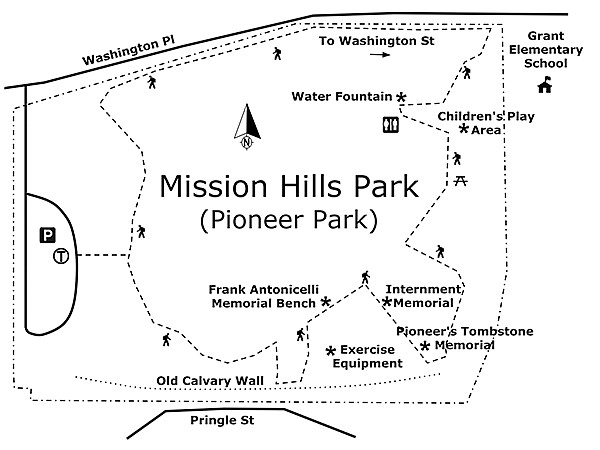
Sitting atop Pringle Hill in Mission Hills, next to the Ulysses S. Grant School, is Mission Hills Park, also known as Pioneer Park and originally named Calvary Cemetery. This unassuming cemetery holds people that date back to when San Diego was an outpost with a population of 250. While the headstones have been removed, except a bank marking a memorial and commemorative ground level plaques, the sprawling lawn, with its non-native plants, now has a children's play area, restroom facilities, and an open space that accommodates summer concerts and permitted picnics and weddings.
Old adobe wall and stairway along southern boundary
Calvary Cemetery was the second cemetery designated in San Diego. Calvary was needed because the El Campo Santo Catholic Cemetery in Old Town was full. Joseph S. Mannasse, an early land developer, had obtained the land that would eventually hold Calvary Cemetery in February 1869 from the City of San Diego. In July 1873, San Diego purchased 10 acres back from Mannasse and in October 1873, the Catholic Diocese acquired 5 acres of the land from the City for the cemetery. Calvary Cemetery was established in 1876.
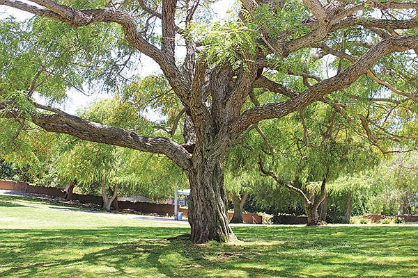
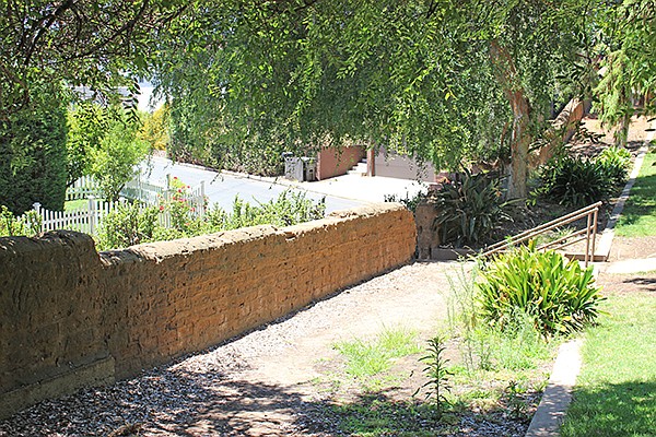
From the parking lot, turn right and head south, taking the concrete path through the Peruvian pepper trees. To your right, remnants of the old adobe wall that once enclosed Calvary can be seen along the southern boundary of the property. Early San Diegan Albert V. Mayrhofer, deeply troubled after repeated vandalisms, collected $15,000 in small donations from descendants of those buried in Calvary and appealed to the Works Project Administration (WPA) to help secure funds and workers to build an adobe wall around the cemetery. After months of bureaucratic red tape, Mayrhofer appealed directly to the White House and secured the support of President Franklin D. Roosevelt. The old stairwell descends onto Pringle Hill and offers a view of the southern side of the old adobe wall.
As you make your way east along the concrete path, you'll pass exercise equipment on your right. Further east you will come to the Frank Antonicelli Memorial Bench, named after the Mission Hills nurseryman who spearheaded the creation and beautification of Pioneer Park. Antonicelli was buried in the defunct Calvary Cemetery in 2002.
As you continue east along the path, you will come upon an internment memorial on the right, consisting of six ground level plaques and a dedication set in concrete in 1988. The plaques list some of the names of those interred at Calvary. In 1957, California enacted laws that allowed the government to convert abandoned cemeteries into pioneer parks. The law also provided for the removal of headstones and memorials and the creation of a central memorial to honor those buried during the life of the park. In 1961, the City began the process of converting the cemetery into a park and in 1968, the Catholic Diocese executed a quit claim deed, abandoning the property. In 1968, through a municipal law, San Diego declared Calvary Cemetery to be abandoned and soon commenced to remove and dump the tombstones into a ravine at another local cemetery, Mount Hope.
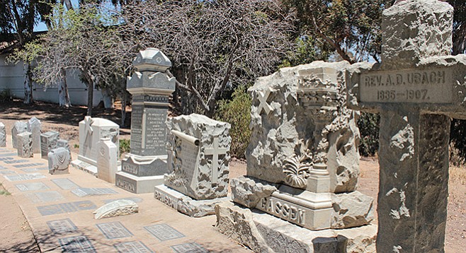
Beyond the internment memorial in the southwest corner of the park is a bank of salvaged tombstones serving as a memorial to prominent early San Diegans and is the only indication that Calvary Cemetery ever existed. Thanks to a living pioneer, F.H. LaBaum, the tombstones were preserved. In 1949, LaBaum visited Calvary Cemetery and, shocked by what he found, wrote a letter to the San Diego City Council and the San Diego Historical Society asking, "Are not Albert V. Mayrhofer, who restored our Mission, and Father Antonio D. Ubach, San Diego's first parish priest, worthy of better environment than we find here?
If the property is owned by the City of San Diego, then it should seem imperative that this hallowed ground be effectively maintained as one of the City's historic spots." Albert V. Mayrhofer was one of San Diego's most prominent Catholic lay persons and, despite the poor condition of Calvary, insisted on being laid to rest there because a brother who died before Albert was born was laid to rest in the cemetery. Albert died in 1948, and Marie Louise Mayrhofer was so concerned about vandalism at Calvary that she refused to put a marker on her husband's grave for over ten months, for fear that her husband's resting place would be violated. Father Ubach and Albert Mayrhofer rest side by side at Calvary.
Also among those buried at Calvary are two prominent early San Diegans, Captain Cave Johnson Couts, "a dashing West Pointer," and his wife Ysidora Bandini, "the loveliest of the Bandini daughters." Both are buried side by side in Calvary Cemetery. Captain Couts was a member of the same class at West Point which produced U.S. Grant, Robert E. Lee and William Tecumseh Sherman. Ysidora's father, Don Juan Bandini, had a cattle ranch on Coronado Island and a sheep ranch on North Island. Additional portions of the old adobe wall can also be seen along the eastern border of the park.
Heading north along the concrete path, on the right is a children's play area with multiple picnic benches beneath the eucalyptus trees. In the northeast corner of the park is a commemorative plaque set in a boulder honoring those that contributed to the building of the children's park. West of the children's play area, you will find a drinking fountain and public restrooms. From the children's play area, you can stroll through the grassy lawn or take the side walk along the north border back around to the parking area.
Canyoneers are San Diego Natural History Museum volunteers trained to lead interpretive nature walks that teach appreciation for the great outdoors. For a schedule of free public hikes, refer to the San Diego Natural History Museum website.
MISSION HILLS PARK (PIONEER PARK)
Discover an historic cemetery that is now a recreation area
MISSION HILLS PARK (PIONEER PARK) Map
Driving directions: (Mission Hills) From Interstate 5, exit Washington Street and head east up the hill for 0.9 mile. Turn left onto Goldfinch Street. In one block, turn left onto Fort Stockton Drive. In two blocks, turn left on Ingalls Street. In one block, turn right onto Washington Place and go 0.3 mile. The park will be on your left just past Grant Elementary School. There is a small parking lot limited to a handful of cars and there is also street parking. Hiking length: 0.5 mile; around the park. Allow 1 hour exploring and walking time. Difficulty: Easy. Gentle slopping lawn and concrete walkways easily accommodates strollers, wheelchairs and dogs on a leash.
Here's something you might be interested in.
An unassuming cemetery in Mission Hills
Salvaged tombstones are the only indication that Calvary Cemetery ever existed
An unassuming cemetery in Mission Hills
Salvaged tombstones are the only indication that Calvary Cemetery ever existed
Bank of memorial tombstones in the southeast corner of the park
Peruvian pepper trees shading the grassy lawn
Sitting atop Pringle Hill in Mission Hills, next to the Ulysses S. Grant School, is Mission Hills Park, also known as Pioneer Park and originally named Calvary Cemetery. This unassuming cemetery holds people that date back to when San Diego was an outpost with a population of 250. While the headstones have been removed, except a bank marking a memorial and commemorative ground level plaques, the sprawling lawn, with its non-native plants, now has a children's play area, restroom facilities, and an open space that accommodates summer concerts and permitted picnics and weddings.
Old adobe wall and stairway along southern boundary
Calvary Cemetery was the second cemetery designated in San Diego. Calvary was needed because the El Campo Santo Catholic Cemetery in Old Town was full. Joseph S. Mannasse, an early land developer, had obtained the land that would eventually hold Calvary Cemetery in February 1869 from the City of San Diego. In July 1873, San Diego purchased 10 acres back from Mannasse and in October 1873, the Catholic Diocese acquired 5 acres of the land from the City for the cemetery. Calvary Cemetery was established in 1876.
From the parking lot, turn right and head south, taking the concrete path through the Peruvian pepper trees. To your right, remnants of the old adobe wall that once enclosed Calvary can be seen along the southern boundary of the property. Early San Diegan Albert V. Mayrhofer, deeply troubled after repeated vandalisms, collected $15,000 in small donations from descendants of those buried in Calvary and appealed to the Works Project Administration (WPA) to help secure funds and workers to build an adobe wall around the cemetery. After months of bureaucratic red tape, Mayrhofer appealed directly to the White House and secured the support of President Franklin D. Roosevelt. The old stairwell descends onto Pringle Hill and offers a view of the southern side of the old adobe wall.
As you make your way east along the concrete path, you'll pass exercise equipment on your right. Further east you will come to the Frank Antonicelli Memorial Bench, named after the Mission Hills nurseryman who spearheaded the creation and beautification of Pioneer Park. Antonicelli was buried in the defunct Calvary Cemetery in 2002.
As you continue east along the path, you will come upon an internment memorial on the right, consisting of six ground level plaques and a dedication set in concrete in 1988. The plaques list some of the names of those interred at Calvary. In 1957, California enacted laws that allowed the government to convert abandoned cemeteries into pioneer parks. The law also provided for the removal of headstones and memorials and the creation of a central memorial to honor those buried during the life of the park. In 1961, the City began the process of converting the cemetery into a park and in 1968, the Catholic Diocese executed a quit claim deed, abandoning the property. In 1968, through a municipal law, San Diego declared Calvary Cemetery to be abandoned and soon commenced to remove and dump the tombstones into a ravine at another local cemetery, Mount Hope.
Beyond the internment memorial in the southwest corner of the park is a bank of salvaged tombstones serving as a memorial to prominent early San Diegans and is the only indication that Calvary Cemetery ever existed. Thanks to a living pioneer, F.H. LaBaum, the tombstones were preserved. In 1949, LaBaum visited Calvary Cemetery and, shocked by what he found, wrote a letter to the San Diego City Council and the San Diego Historical Society asking, "Are not Albert V. Mayrhofer, who restored our Mission, and Father Antonio D. Ubach, San Diego's first parish priest, worthy of better environment than we find here?
If the property is owned by the City of San Diego, then it should seem imperative that this hallowed ground be effectively maintained as one of the City's historic spots." Albert V. Mayrhofer was one of San Diego's most prominent Catholic lay persons and, despite the poor condition of Calvary, insisted on being laid to rest there because a brother who died before Albert was born was laid to rest in the cemetery. Albert died in 1948, and Marie Louise Mayrhofer was so concerned about vandalism at Calvary that she refused to put a marker on her husband's grave for over ten months, for fear that her husband's resting place would be violated. Father Ubach and Albert Mayrhofer rest side by side at Calvary.
Also among those buried at Calvary are two prominent early San Diegans, Captain Cave Johnson Couts, "a dashing West Pointer," and his wife Ysidora Bandini, "the loveliest of the Bandini daughters." Both are buried side by side in Calvary Cemetery. Captain Couts was a member of the same class at West Point which produced U.S. Grant, Robert E. Lee and William Tecumseh Sherman. Ysidora's father, Don Juan Bandini, had a cattle ranch on Coronado Island and a sheep ranch on North Island. Additional portions of the old adobe wall can also be seen along the eastern border of the park.
Heading north along the concrete path, on the right is a children's play area with multiple picnic benches beneath the eucalyptus trees. In the northeast corner of the park is a commemorative plaque set in a boulder honoring those that contributed to the building of the children's park. West of the children's play area, you will find a drinking fountain and public restrooms. From the children's play area, you can stroll through the grassy lawn or take the side walk along the north border back around to the parking area.
Canyoneers are San Diego Natural History Museum volunteers trained to lead interpretive nature walks that teach appreciation for the great outdoors. For a schedule of free public hikes, refer to the San Diego Natural History Museum website.
MISSION HILLS PARK (PIONEER PARK)
Discover an historic cemetery that is now a recreation area
MISSION HILLS PARK (PIONEER PARK) Map
Driving directions: (Mission Hills) From Interstate 5, exit Washington Street and head east up the hill for 0.9 mile. Turn left onto Goldfinch Street. In one block, turn left onto Fort Stockton Drive. In two blocks, turn left on Ingalls Street. In one block, turn right onto Washington Place and go 0.3 mile. The park will be on your left just past Grant Elementary School. There is a small parking lot limited to a handful of cars and there is also street parking. Hiking length: 0.5 mile; around the park. Allow 1 hour exploring and walking time. Difficulty: Easy. Gentle slopping lawn and concrete walkways easily accommodates strollers, wheelchairs and dogs on a leash.
Comments