Here's something you might be interested in.
Ask a Hipster — Advice you didn't know you needed
Big Screen — Movie commentary
Blurt — Music's inside track
Booze News — San Diego spirits
Classical Music — Immortal beauty
Classifieds — Free and easy
Close to Home — What it’s like on the street where you live
Cover Stories — Front-page features
Drinks All Around — Bartenders' drink recipes
Excerpts — Literary and spiritual excerpts
Feast! — Food & drink reviews
Feature Stories — Local news & stories
Fishing Report — What’s getting hooked from ship and shore
From the Archives — Spotlight on the past
Golden Dreams — Talk of the town
The Gonzo Report — Making the musical scene, or at least reporting from it
Letters — Our inbox
Movies@Home — Local movie buffs share favorites
Movie Reviews — Our critics' picks and pans
Musician Interviews — Up close with local artists
Neighborhood News from Stringers — Hyperlocal news
News Ticker — News & politics
Obermeyer — San Diego politics illustrated
Outdoors — Weekly changes in flora and fauna
Overheard in San Diego — Eavesdropping illustrated
Poetry — The old and the new
Reader Travel — Travel section built by travelers
Reading — The hunt for intellectuals
Roam-O-Rama — SoCal's best hiking/biking trails
San Diego Beer — Inside San Diego suds
SD on the QT — Almost factual news
Sheep and Goats — Places of worship
Special Issues — The best of
Street Style — San Diego streets have style
Surf Diego — Real stories from those braving the waves
Theater — On stage in San Diego this week
Tin Fork — Silver spoon alternative
Under the Radar — Matt Potter's undercover work
Unforgettable — Long-ago San Diego
Unreal Estate — San Diego's priciest pads
Your Week — Daily event picks
Lost meaning in Smugglers Canyon
Maybe the pictographs were used in female initiation ceremonies
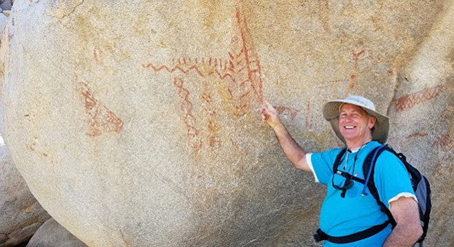
A hiker points out the mysterious pictographs
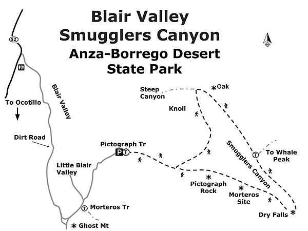
After parking at the Pictograph Trail trailhead, begin your hike by heading east up the well-marked Pictograph Trail. Be sure to take a moment to read the informational kiosk so you understand the importance and the sensitivity of this location. At just under a mile of mostly sandy wash, you will come to a massive, rectangular-shaped boulder on your right. Here you will find a collection of fading pictographs on its vertical surface. This particular site has been designated as CA-SDI-31 in the California Historic Resources system, which means it is one of the earliest archaeological locations recorded in San Diego County.
The rock art found here is in the form of diamond chains, zigzags, rays, and dots. The materials used to create the red-colored pigments, such as red iron oxides, were gathered locally, and combined with oils from plants or fat from animals. These particular pictographs are considered to be of the San Luis Rey style of rock art. This site is the southernmost example of this style found in Southern California. While the actual meaning of these pictures is lost to us now, it is thought by some experts that they may have been used as part of female initiation ceremonies. The age of this rock art is also unknown but is estimated to be anywhere from 200 to 1000 years old.
Visitors to any pictograph sites should conduct themselves with respect since these places are sacred to the Native American peoples. Do not touch the paintings or the surface of the rock where paintings are present, as this can easily cause irreparable damage. This site, as well as all archaeological sites within Anza-Borrego Desert State Park, is protected by law.
In addition to the rock art, you will also find a variety of native desert vegetation along the trail. Gander’s and teddy bear cholla are beautiful to look at, but be sure to give them a wide berth since their sharp spines easily attach themself to the unwary hiker. Ocotillo, desert agave, cat’s claw, and Mojave yucca are also primed to deliver a nasty jab or cut if inspected too closely.
If time or difficulty is a concern, this is a good point to turn around. If you are in the mood for a bit more of a challenge, then continue east on the same trail as it bends off to the right (south), walking through a wash towards the nearby gorge. The trail continues on into the boulders of the gorge known as Smugglers Canyon. On your way, take a few moments to wander off to the right side, through a large boulder pile, to find an ancient Indian village mortero site.
As you arrive at the gorge, you will encounter a bit of mild bouldering. Be careful, as this trail comes to an abrupt end at the precipice of the 70-foot Smugglers Canyon drop off dry waterfall.
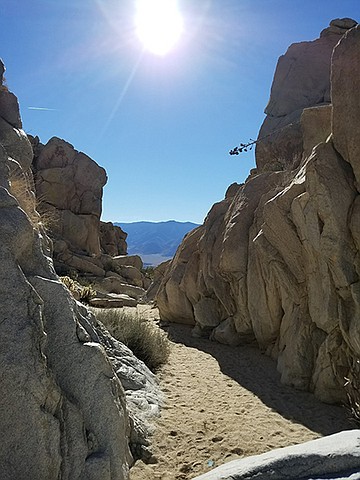
Trail leads through a narrow gorge to a spectacular view of Vallecito Valley
The view to the south is spectacular, giving an overview of the Vallecitos Valley and Stagecoach County Park on S-2. To continue the hike, return back up the wash, but now on the east side, along the edge of the mountains. About halfway up the wash, look for a U-shaped area of boulders leading back into the Vallecito Mountains. With a bit of searching, you will find a trailhead leading up to the top of Whale Peak (but this is a long hike for another time). Our hike continues on up the east side to the top of the wash to explore the large boulder formations there. Watch for interesting plants tucked into the boulders along the way. Many are California juniper—be sure to look for their light blue berries, which are not really berries but rather female seed cones that are fleshy, with merged scales that give it a berry-like appearance. At the top, see if you can look for a very special treat, a lone Muller’s oak tree (Quercus cornelius-mulleri)!
To complete the hike, it is best to back-track around the knoll at the top of the wash and return on the Pictograph Trail, rather than heading off down the nearby dry waterfall canyon off to the west. That canyon is steep, with jumbled boulders of all sizes, many of them loose. There is no trail down this very sensitive canyon.
Directions: (Ocotillo) From I-8 E, exit on Imperial Hwy. (S-2) at Ocotillo. Turn left on S-2 and go 41.5 miles to the signed entrance to Blair Valley on the right. There is also a sign here for the old Butterfield Stage Route. Follow the maintained dirt road (high clearance vehicles) south around Blair Valley, keeping the rock strewn mountains on your left. After about 3 miles the road will fork. To the right is Ghost Mountain (Marshal South’s Desert Experiment). Take the fork to the left. After 0.2 mile you will pass the Morteros Trail parking area and then very shortly after the road splits with the left-hand fork going into Little Blair Valley. Follow the right fork north then east for another 2 miles to the end of the road. You are now at the parking area for the Pictograph Trail. Alternate route: from Julian, take CA-78 (Main St.) east and go 11.5 miles. Turn right on Great Southern Overland Stage Rte. (S-2). Go 6 miles to the signed entrance to Blair Valley on the left side of the road. Follow the directions above once on the maintained dirt road.
Hiking length: 5.5 miles. Allow 4 hours hiking time.
Difficulty: Easy, then becoming intermediate at Smugglers Canyon. Elevation gain/loss 400 feet. Be careful of sensitive areas, stay in the sandy parts of the wash to avoid disturbing plant life. Avoid the steep canyon areas with no trails, abrupt drop offs, loose boulders, etc.
Other: Like most desert hikes, this one is best done in late fall, winter, and early spring due to the summer heat.
Here's something you might be interested in.
Lost meaning in Smugglers Canyon
Maybe the pictographs were used in female initiation ceremonies
Lost meaning in Smugglers Canyon
Maybe the pictographs were used in female initiation ceremonies
A hiker points out the mysterious pictographs
After parking at the Pictograph Trail trailhead, begin your hike by heading east up the well-marked Pictograph Trail. Be sure to take a moment to read the informational kiosk so you understand the importance and the sensitivity of this location. At just under a mile of mostly sandy wash, you will come to a massive, rectangular-shaped boulder on your right. Here you will find a collection of fading pictographs on its vertical surface. This particular site has been designated as CA-SDI-31 in the California Historic Resources system, which means it is one of the earliest archaeological locations recorded in San Diego County.
The rock art found here is in the form of diamond chains, zigzags, rays, and dots. The materials used to create the red-colored pigments, such as red iron oxides, were gathered locally, and combined with oils from plants or fat from animals. These particular pictographs are considered to be of the San Luis Rey style of rock art. This site is the southernmost example of this style found in Southern California. While the actual meaning of these pictures is lost to us now, it is thought by some experts that they may have been used as part of female initiation ceremonies. The age of this rock art is also unknown but is estimated to be anywhere from 200 to 1000 years old.
Visitors to any pictograph sites should conduct themselves with respect since these places are sacred to the Native American peoples. Do not touch the paintings or the surface of the rock where paintings are present, as this can easily cause irreparable damage. This site, as well as all archaeological sites within Anza-Borrego Desert State Park, is protected by law.
In addition to the rock art, you will also find a variety of native desert vegetation along the trail. Gander’s and teddy bear cholla are beautiful to look at, but be sure to give them a wide berth since their sharp spines easily attach themself to the unwary hiker. Ocotillo, desert agave, cat’s claw, and Mojave yucca are also primed to deliver a nasty jab or cut if inspected too closely.
If time or difficulty is a concern, this is a good point to turn around. If you are in the mood for a bit more of a challenge, then continue east on the same trail as it bends off to the right (south), walking through a wash towards the nearby gorge. The trail continues on into the boulders of the gorge known as Smugglers Canyon. On your way, take a few moments to wander off to the right side, through a large boulder pile, to find an ancient Indian village mortero site.
As you arrive at the gorge, you will encounter a bit of mild bouldering. Be careful, as this trail comes to an abrupt end at the precipice of the 70-foot Smugglers Canyon drop off dry waterfall.
Trail leads through a narrow gorge to a spectacular view of Vallecito Valley
The view to the south is spectacular, giving an overview of the Vallecitos Valley and Stagecoach County Park on S-2. To continue the hike, return back up the wash, but now on the east side, along the edge of the mountains. About halfway up the wash, look for a U-shaped area of boulders leading back into the Vallecito Mountains. With a bit of searching, you will find a trailhead leading up to the top of Whale Peak (but this is a long hike for another time). Our hike continues on up the east side to the top of the wash to explore the large boulder formations there. Watch for interesting plants tucked into the boulders along the way. Many are California juniper—be sure to look for their light blue berries, which are not really berries but rather female seed cones that are fleshy, with merged scales that give it a berry-like appearance. At the top, see if you can look for a very special treat, a lone Muller’s oak tree (Quercus cornelius-mulleri)!
To complete the hike, it is best to back-track around the knoll at the top of the wash and return on the Pictograph Trail, rather than heading off down the nearby dry waterfall canyon off to the west. That canyon is steep, with jumbled boulders of all sizes, many of them loose. There is no trail down this very sensitive canyon.
Directions: (Ocotillo) From I-8 E, exit on Imperial Hwy. (S-2) at Ocotillo. Turn left on S-2 and go 41.5 miles to the signed entrance to Blair Valley on the right. There is also a sign here for the old Butterfield Stage Route. Follow the maintained dirt road (high clearance vehicles) south around Blair Valley, keeping the rock strewn mountains on your left. After about 3 miles the road will fork. To the right is Ghost Mountain (Marshal South’s Desert Experiment). Take the fork to the left. After 0.2 mile you will pass the Morteros Trail parking area and then very shortly after the road splits with the left-hand fork going into Little Blair Valley. Follow the right fork north then east for another 2 miles to the end of the road. You are now at the parking area for the Pictograph Trail. Alternate route: from Julian, take CA-78 (Main St.) east and go 11.5 miles. Turn right on Great Southern Overland Stage Rte. (S-2). Go 6 miles to the signed entrance to Blair Valley on the left side of the road. Follow the directions above once on the maintained dirt road.
Hiking length: 5.5 miles. Allow 4 hours hiking time.
Difficulty: Easy, then becoming intermediate at Smugglers Canyon. Elevation gain/loss 400 feet. Be careful of sensitive areas, stay in the sandy parts of the wash to avoid disturbing plant life. Avoid the steep canyon areas with no trails, abrupt drop offs, loose boulders, etc.
Other: Like most desert hikes, this one is best done in late fall, winter, and early spring due to the summer heat.
Comments