Here's something you might be interested in.
Ask a Hipster — Advice you didn't know you needed
Big Screen — Movie commentary
Blurt — Music's inside track
Booze News — San Diego spirits
Classical Music — Immortal beauty
Classifieds — Free and easy
Close to Home — What it’s like on the street where you live
Cover Stories — Front-page features
Drinks All Around — Bartenders' drink recipes
Excerpts — Literary and spiritual excerpts
Feast! — Food & drink reviews
Feature Stories — Local news & stories
Fishing Report — What’s getting hooked from ship and shore
From the Archives — Spotlight on the past
Golden Dreams — Talk of the town
The Gonzo Report — Making the musical scene, or at least reporting from it
Letters — Our inbox
Movies@Home — Local movie buffs share favorites
Movie Reviews — Our critics' picks and pans
Musician Interviews — Up close with local artists
Neighborhood News from Stringers — Hyperlocal news
News Ticker — News & politics
Obermeyer — San Diego politics illustrated
Outdoors — Weekly changes in flora and fauna
Overheard in San Diego — Eavesdropping illustrated
Poetry — The old and the new
Reader Travel — Travel section built by travelers
Reading — The hunt for intellectuals
Roam-O-Rama — SoCal's best hiking/biking trails
San Diego Beer — Inside San Diego suds
SD on the QT — Almost factual news
Sheep and Goats — Places of worship
Special Issues — The best of
Street Style — San Diego streets have style
Surf Diego — Real stories from those braving the waves
Theater — On stage in San Diego this week
Tin Fork — Silver spoon alternative
Under the Radar — Matt Potter's undercover work
Unforgettable — Long-ago San Diego
Unreal Estate — San Diego's priciest pads
Your Week — Daily event picks
Little worry of getting lost
Beauty between the 94, Sweetwater River, Steele Canyon, and Cottonwood Golf Course
Although it is tempting to try to find the river, poison oak is plentiful there.
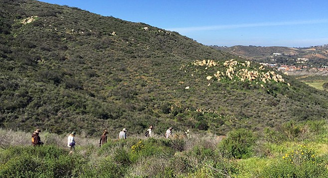
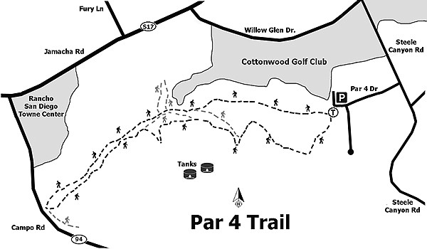
The relatively unknown Par 4 trails wind through the east end of San Diego National Wildlife Refuge’s Sweetwater River Unit. The area is boxed in by Highway 94 to the south and west; Steele Canyon Road to the east; and the Sweetwater River, Cottonwood Golf Course, and Rancho San Diego to the north, making the promontory seemingly difficult to access. The easiest way in is to park at the trailhead at the end of Par 4 Drive, accessed from Steele Canyon Road. There is no official parking lot or cul-de-sac on this residential road, so be respectful of private property and driveways when parking.
There are many interconnecting trails running through the area.
From the San Diego National Wildlife Refuge kiosk, a loop is possible by taking the left fork up and west, or going right and following the intermittently fenced trail through the Sweetwater River flood plain along Cottonwood Golf Course. There are many interconnecting trails running through the area that can be confusing in places, but there is little worry of getting lost. The relatively flat flood-plain section of the trail is only 1.4 miles long. At the west end, there is no trail, though passage under the SR-94 bridge is a bit sketchy getting over the rocks that connect to the trail and Interpretative Loop on the west arm of the refuge.
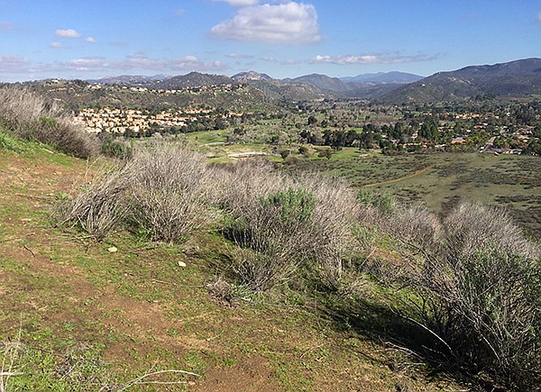
The views of San Miguel Peak, the refuge to the west, and the Sweetwater River’s lush green valley are worth the short climb.
Get your bearings by sticking to the wide right fork. The trail goes through an expanse of invasive mustards and grasses mixed with buckwheat and chaparral broom. If you look closely, one can find the rare San Diego ambrosia growing along the trail in disturbed soils.
The trail eventually ascends to the southwest, passing junctions with higher trails that can be used to return. Eventually (around 0.75 mile) the trail passes along the edge of the golf course and comes to another “Y” junction. The right fork goes up a small hill with views of the dense riparian forest along the Sweetwater River and the surrounding urban development of Rancho San Diego. After checking out the view, continue west to another knob and a large pile of rocks with a memorial plaque. The trail continues with more trails entering from the left, but keep right, close to the river’s course.
At about a mile, enormous coast live oak trees will begin to appear along the trail. This one section is shaded and cool in the heat of summer. Oak, willow, and wild grape dress the trail, and although it is tempting to try to find the river, poison oak is plentiful here. There are a few spots where patches of water in the riverbed can be seen from the trail.
The trail seems to end abruptly at 1.4 miles, diving into the thicket of an oak tree near the bridge abutment. This is where you can cross under SR-94 and come up at the old steel bridge to access the west side of the refuge and/or connect to Singer Drive.
To complete the loop, do not cross and take a left turn on the trail. Now your choices are many, the easiest being to turn back east and follow the higher trail that parallels the trail you were just on. At about half a mile, this trail forks; go right/south at the junction. The trail will go up onto the hillside and offer some great views of the riparian woodland along the river and beyond.
The thick vegetation on this north-facing slope harbors beautiful native shrubs and euphorbia species. Yellow chaparral beardtongue, bush monkey flower, species of phacelia, yarrow, snapdragon, and penstemon are showy in early summer. Sumac, buckwheat, sugarbush, and other shrubs provide habitat for brown and spotted towhees, California thrashers, hummingbirds, lesser goldfinch, and the rare California gnatcatcher. Again, the trail has many spurs that will take to the higher ground, even one that climbs to the top of the ridge. It would take many hikes to explore the multitude of trails bisecting this little patch of land.
If continuing on the hillside trail, it descends to the flood plain and trailhead where you started. While walking the sandy final stretch, look for the camouflaged horned lizards feeding on the harvester ants that nest in the trail. This loop is about 3.2 miles total, the return route being 1.75 miles.
Other options back are varied, as the trail splits into many choices. If the trail taken was to parallel along Highway 94, it would have soon intersected a partially paved road up to the top of the ridge where two water tanks sit. This is not a particularly nice trail, but the views of San Miguel Peak, the refuge to the west, and the Sweetwater River’s lush green valley are well worth the short climb. At the top, the trail wraps around the south side (right) of the tanks and looks down on the 94 and Steele Canyon High School. Stay on the road just below the ridge. About 100 yards east of the water tanks, look for a wide disturbed area to the trail’s left. The trail leaves the road heading east; at a switchback turning west, it abruptly climbs down along the north face of the ridge. The trail is not steep but is deeply cut by the hooves of horses and can be overgrown with mustard on both sides, which can be visually unnerving. At the fork, go left or right; both trails eventually connect to the upper trail described in the loop above, and going east (right) is a way back to the trailhead.
Distance from downtown San Diego: 17 miles (Rancho San Diego). Allow 30 minutes driving time. From SR-94 E/Campo Road, continue straight through Rancho San Diego on Jamacha Road for almost 1 mile, then take a right on Willow Glen Drive for 0.8 mile. At the next light, turn right on Steele Canyon Road for 0.4 mile. Par 4 Drive is the second left.
Limited parking can be found at the end of Par 4 Drive. The trailhead kiosk is beyond the gate to the left (west). No facilities or water.
Hours: Sunrise to sunset.
Hiking length: 3.2-mile loop with many longer and higher elevation options available.
Difficulty: Easy. Elevation gain/loss less than 400 feet. Equestrians, bicycles, and leashed dogs allowed.
Here's something you might be interested in.
Little worry of getting lost
Beauty between the 94, Sweetwater River, Steele Canyon, and Cottonwood Golf Course
Little worry of getting lost
Beauty between the 94, Sweetwater River, Steele Canyon, and Cottonwood Golf Course
Although it is tempting to try to find the river, poison oak is plentiful there.
The relatively unknown Par 4 trails wind through the east end of San Diego National Wildlife Refuge’s Sweetwater River Unit. The area is boxed in by Highway 94 to the south and west; Steele Canyon Road to the east; and the Sweetwater River, Cottonwood Golf Course, and Rancho San Diego to the north, making the promontory seemingly difficult to access. The easiest way in is to park at the trailhead at the end of Par 4 Drive, accessed from Steele Canyon Road. There is no official parking lot or cul-de-sac on this residential road, so be respectful of private property and driveways when parking.
There are many interconnecting trails running through the area.
From the San Diego National Wildlife Refuge kiosk, a loop is possible by taking the left fork up and west, or going right and following the intermittently fenced trail through the Sweetwater River flood plain along Cottonwood Golf Course. There are many interconnecting trails running through the area that can be confusing in places, but there is little worry of getting lost. The relatively flat flood-plain section of the trail is only 1.4 miles long. At the west end, there is no trail, though passage under the SR-94 bridge is a bit sketchy getting over the rocks that connect to the trail and Interpretative Loop on the west arm of the refuge.
The views of San Miguel Peak, the refuge to the west, and the Sweetwater River’s lush green valley are worth the short climb.
Get your bearings by sticking to the wide right fork. The trail goes through an expanse of invasive mustards and grasses mixed with buckwheat and chaparral broom. If you look closely, one can find the rare San Diego ambrosia growing along the trail in disturbed soils.
The trail eventually ascends to the southwest, passing junctions with higher trails that can be used to return. Eventually (around 0.75 mile) the trail passes along the edge of the golf course and comes to another “Y” junction. The right fork goes up a small hill with views of the dense riparian forest along the Sweetwater River and the surrounding urban development of Rancho San Diego. After checking out the view, continue west to another knob and a large pile of rocks with a memorial plaque. The trail continues with more trails entering from the left, but keep right, close to the river’s course.
At about a mile, enormous coast live oak trees will begin to appear along the trail. This one section is shaded and cool in the heat of summer. Oak, willow, and wild grape dress the trail, and although it is tempting to try to find the river, poison oak is plentiful here. There are a few spots where patches of water in the riverbed can be seen from the trail.
The trail seems to end abruptly at 1.4 miles, diving into the thicket of an oak tree near the bridge abutment. This is where you can cross under SR-94 and come up at the old steel bridge to access the west side of the refuge and/or connect to Singer Drive.
To complete the loop, do not cross and take a left turn on the trail. Now your choices are many, the easiest being to turn back east and follow the higher trail that parallels the trail you were just on. At about half a mile, this trail forks; go right/south at the junction. The trail will go up onto the hillside and offer some great views of the riparian woodland along the river and beyond.
The thick vegetation on this north-facing slope harbors beautiful native shrubs and euphorbia species. Yellow chaparral beardtongue, bush monkey flower, species of phacelia, yarrow, snapdragon, and penstemon are showy in early summer. Sumac, buckwheat, sugarbush, and other shrubs provide habitat for brown and spotted towhees, California thrashers, hummingbirds, lesser goldfinch, and the rare California gnatcatcher. Again, the trail has many spurs that will take to the higher ground, even one that climbs to the top of the ridge. It would take many hikes to explore the multitude of trails bisecting this little patch of land.
If continuing on the hillside trail, it descends to the flood plain and trailhead where you started. While walking the sandy final stretch, look for the camouflaged horned lizards feeding on the harvester ants that nest in the trail. This loop is about 3.2 miles total, the return route being 1.75 miles.
Other options back are varied, as the trail splits into many choices. If the trail taken was to parallel along Highway 94, it would have soon intersected a partially paved road up to the top of the ridge where two water tanks sit. This is not a particularly nice trail, but the views of San Miguel Peak, the refuge to the west, and the Sweetwater River’s lush green valley are well worth the short climb. At the top, the trail wraps around the south side (right) of the tanks and looks down on the 94 and Steele Canyon High School. Stay on the road just below the ridge. About 100 yards east of the water tanks, look for a wide disturbed area to the trail’s left. The trail leaves the road heading east; at a switchback turning west, it abruptly climbs down along the north face of the ridge. The trail is not steep but is deeply cut by the hooves of horses and can be overgrown with mustard on both sides, which can be visually unnerving. At the fork, go left or right; both trails eventually connect to the upper trail described in the loop above, and going east (right) is a way back to the trailhead.
Distance from downtown San Diego: 17 miles (Rancho San Diego). Allow 30 minutes driving time. From SR-94 E/Campo Road, continue straight through Rancho San Diego on Jamacha Road for almost 1 mile, then take a right on Willow Glen Drive for 0.8 mile. At the next light, turn right on Steele Canyon Road for 0.4 mile. Par 4 Drive is the second left.
Limited parking can be found at the end of Par 4 Drive. The trailhead kiosk is beyond the gate to the left (west). No facilities or water.
Hours: Sunrise to sunset.
Hiking length: 3.2-mile loop with many longer and higher elevation options available.
Difficulty: Easy. Elevation gain/loss less than 400 feet. Equestrians, bicycles, and leashed dogs allowed.
Comments