Here's something you might be interested in.
Ask a Hipster — Advice you didn't know you needed
Big Screen — Movie commentary
Blurt — Music's inside track
Booze News — San Diego spirits
Classical Music — Immortal beauty
Classifieds — Free and easy
Close to Home — What it’s like on the street where you live
Cover Stories — Front-page features
Drinks All Around — Bartenders' drink recipes
Excerpts — Literary and spiritual excerpts
Feast! — Food & drink reviews
Feature Stories — Local news & stories
Fishing Report — What’s getting hooked from ship and shore
From the Archives — Spotlight on the past
Golden Dreams — Talk of the town
The Gonzo Report — Making the musical scene, or at least reporting from it
Letters — Our inbox
Movies@Home — Local movie buffs share favorites
Movie Reviews — Our critics' picks and pans
Musician Interviews — Up close with local artists
Neighborhood News from Stringers — Hyperlocal news
News Ticker — News & politics
Obermeyer — San Diego politics illustrated
Outdoors — Weekly changes in flora and fauna
Overheard in San Diego — Eavesdropping illustrated
Poetry — The old and the new
Reader Travel — Travel section built by travelers
Reading — The hunt for intellectuals
Roam-O-Rama — SoCal's best hiking/biking trails
San Diego Beer — Inside San Diego suds
SD on the QT — Almost factual news
Sheep and Goats — Places of worship
Special Issues — The best of
Street Style — San Diego streets have style
Surf Diego — Real stories from those braving the waves
Theater — On stage in San Diego this week
Tin Fork — Silver spoon alternative
Under the Radar — Matt Potter's undercover work
Unforgettable — Long-ago San Diego
Unreal Estate — San Diego's priciest pads
Your Week — Daily event picks
Gaze at oaks from your business park
There are scrub oaks and there are scrub oaks
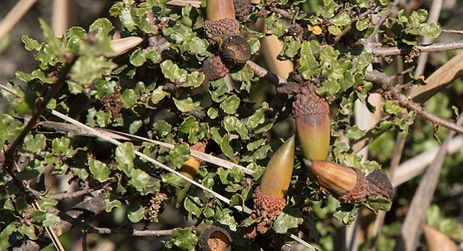
Quercus dumosa was thought to be the most widely distributed scrub oak.
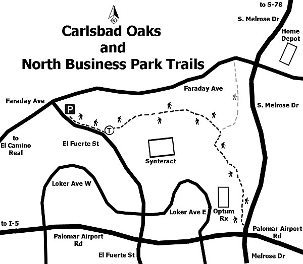
The trailhead is south of the parking area, on the east side of El Fuerte. To reach it, walk about 0.1 mile up the sidewalk to the sign pointing to the trail going east. The Carlsbad Oaks and Business Park trails are directly connected, but they pass through very different terrains and habitats.
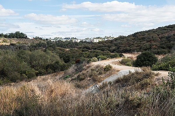
The Oaks Trail is a nearly flat, dirt service access road.
The Oaks Trail is a nearly flat, dirt service access road that extends about three quarters of a mile up a shallow valley. Initially it is above a riparian habitat created by a small dam. After crossing the dam, continue through the oak woodland. Although the shrubs closest to the trail are a mixed elfin forest — containing toyon, coyote bush, laurel sumac, and lemonade berry — coastal scrub oaks (Quercus dumosa) are predominant.
Beginning of trail. One might be tempted to take a short walk down to the stream course.
At one time it was believed that Quercus dumosa was the most widely distributed scrub oak, as the same scrub-oak species was found in high mountains, within many types of chaparral, and in the deserts. However, it was subsequently shown that there are nine genetically different species of scrub oaks in California.
After crossing the dam, continue through the oak woodland.
In San Diego County the three most common scrub oaks are Quercus berberidifolia, the species most likely found in inland chaparral, whereas desert scrub oaks are more likely to be Quercus Cornelius-mulleri. The scrub oak found here, Quercus dumosa, actually is the rarest of the scrub oaks where it grows near the ocean. It is recognized as a sensitive species whose habitat needs protection if it is to survive. For this reason the 328 acres surrounding this trail have been designated the Carlsbad Oaks Habitat Conservation Area.
Coast live oaks (Quercus agrifolia) are closer to the stream that intermittently flows through this valley. Many of these oaks are quite large trees. They form such a dense grove it is difficult to see the individual trees clearly. One might be tempted to take a short walk down to the stream course to view the trees and enjoy their shade, but please stay on the trail. When you reach the east end of the Oaks Trail, a very short unmarked but well-developed trail leads off to the left. It will take you down into the coast live oak forest as well as the streambed.
Turn right at the end of the Oaks Trail and ascend to the Business Park Trail, which is also an unpaved dirt path. The trail makes a steep but short ascent up and over a ridge. As it goes up the hillside, the oaks thin out and there are more coastal sage scrub species. These include black sage, California sagebrush, and coyote bush; also many invasive and other nonnatives, including Indian fig cactus (Opuntia ficus-indica), caster bean (Ricinus communis), black mustard (Brassica nigra), and tocalote (Centaurea melitensis).
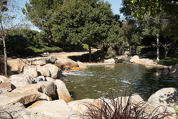
After descending the ridge, the trail becomes a more formal decomposed granite path, paralleling South Melrose and passing near local businesses, as it progresses through a development called the Palomar Forum Business Park. This is a public park with exotic landscaping, an artificial pond with waterfalls, and picnic tables. The park and trail extend to within a few dozen feet of the intersection of South Melrose Drive and Palomar Airport Road. Except for the noisy location, this would be a good place for lunch. In any event, at 1.32 miles from the trailhead, it is time to turn around and return to the start of this walk.
Distance from downtown San Diego: 33 miles (Carlsbad). Allow 50 minutes driving time. From I-5, exit at Palomar Road and travel east about 4 miles before turning left (north) onto El Fuerte Street. Continue down El Fuerte Street until close to the junction with Faraday Ave. There is a pump station on the right with a small landscaped area, picnic tables, and public parking.
Hiking length: 2.5 miles out-and-back. Difficulty: Easy/moderate with elevation gain/loss of 300 feet. Bicycles and leashed dogs are allowed. No facilities.
Here's something you might be interested in.
Gaze at oaks from your business park
There are scrub oaks and there are scrub oaks
Gaze at oaks from your business park
There are scrub oaks and there are scrub oaks
Quercus dumosa was thought to be the most widely distributed scrub oak.
The trailhead is south of the parking area, on the east side of El Fuerte. To reach it, walk about 0.1 mile up the sidewalk to the sign pointing to the trail going east. The Carlsbad Oaks and Business Park trails are directly connected, but they pass through very different terrains and habitats.
The Oaks Trail is a nearly flat, dirt service access road.
The Oaks Trail is a nearly flat, dirt service access road that extends about three quarters of a mile up a shallow valley. Initially it is above a riparian habitat created by a small dam. After crossing the dam, continue through the oak woodland. Although the shrubs closest to the trail are a mixed elfin forest — containing toyon, coyote bush, laurel sumac, and lemonade berry — coastal scrub oaks (Quercus dumosa) are predominant.
Beginning of trail. One might be tempted to take a short walk down to the stream course.
At one time it was believed that Quercus dumosa was the most widely distributed scrub oak, as the same scrub-oak species was found in high mountains, within many types of chaparral, and in the deserts. However, it was subsequently shown that there are nine genetically different species of scrub oaks in California.
After crossing the dam, continue through the oak woodland.
In San Diego County the three most common scrub oaks are Quercus berberidifolia, the species most likely found in inland chaparral, whereas desert scrub oaks are more likely to be Quercus Cornelius-mulleri. The scrub oak found here, Quercus dumosa, actually is the rarest of the scrub oaks where it grows near the ocean. It is recognized as a sensitive species whose habitat needs protection if it is to survive. For this reason the 328 acres surrounding this trail have been designated the Carlsbad Oaks Habitat Conservation Area.
Coast live oaks (Quercus agrifolia) are closer to the stream that intermittently flows through this valley. Many of these oaks are quite large trees. They form such a dense grove it is difficult to see the individual trees clearly. One might be tempted to take a short walk down to the stream course to view the trees and enjoy their shade, but please stay on the trail. When you reach the east end of the Oaks Trail, a very short unmarked but well-developed trail leads off to the left. It will take you down into the coast live oak forest as well as the streambed.
Turn right at the end of the Oaks Trail and ascend to the Business Park Trail, which is also an unpaved dirt path. The trail makes a steep but short ascent up and over a ridge. As it goes up the hillside, the oaks thin out and there are more coastal sage scrub species. These include black sage, California sagebrush, and coyote bush; also many invasive and other nonnatives, including Indian fig cactus (Opuntia ficus-indica), caster bean (Ricinus communis), black mustard (Brassica nigra), and tocalote (Centaurea melitensis).
After descending the ridge, the trail becomes a more formal decomposed granite path, paralleling South Melrose and passing near local businesses, as it progresses through a development called the Palomar Forum Business Park. This is a public park with exotic landscaping, an artificial pond with waterfalls, and picnic tables. The park and trail extend to within a few dozen feet of the intersection of South Melrose Drive and Palomar Airport Road. Except for the noisy location, this would be a good place for lunch. In any event, at 1.32 miles from the trailhead, it is time to turn around and return to the start of this walk.
Distance from downtown San Diego: 33 miles (Carlsbad). Allow 50 minutes driving time. From I-5, exit at Palomar Road and travel east about 4 miles before turning left (north) onto El Fuerte Street. Continue down El Fuerte Street until close to the junction with Faraday Ave. There is a pump station on the right with a small landscaped area, picnic tables, and public parking.
Hiking length: 2.5 miles out-and-back. Difficulty: Easy/moderate with elevation gain/loss of 300 feet. Bicycles and leashed dogs are allowed. No facilities.
Comments