Here's something you might be interested in.
Ask a Hipster — Advice you didn't know you needed
Big Screen — Movie commentary
Blurt — Music's inside track
Booze News — San Diego spirits
Classical Music — Immortal beauty
Classifieds — Free and easy
Close to Home — What it’s like on the street where you live
Cover Stories — Front-page features
Drinks All Around — Bartenders' drink recipes
Excerpts — Literary and spiritual excerpts
Feast! — Food & drink reviews
Feature Stories — Local news & stories
Fishing Report — What’s getting hooked from ship and shore
From the Archives — Spotlight on the past
Golden Dreams — Talk of the town
The Gonzo Report — Making the musical scene, or at least reporting from it
Letters — Our inbox
Movies@Home — Local movie buffs share favorites
Movie Reviews — Our critics' picks and pans
Musician Interviews — Up close with local artists
Neighborhood News from Stringers — Hyperlocal news
News Ticker — News & politics
Obermeyer — San Diego politics illustrated
Outdoors — Weekly changes in flora and fauna
Overheard in San Diego — Eavesdropping illustrated
Poetry — The old and the new
Reader Travel — Travel section built by travelers
Reading — The hunt for intellectuals
Roam-O-Rama — SoCal's best hiking/biking trails
San Diego Beer — Inside San Diego suds
SD on the QT — Almost factual news
Sheep and Goats — Places of worship
Special Issues — The best of
Street Style — San Diego streets have style
Surf Diego — Real stories from those braving the waves
Theater — On stage in San Diego this week
Tin Fork — Silver spoon alternative
Under the Radar — Matt Potter's undercover work
Unforgettable — Long-ago San Diego
Unreal Estate — San Diego's priciest pads
Your Week — Daily event picks
Views of homes and ranches where Kumeyaay once lived
Follow a zigzag trail to a view point that ends at the old Flume Trail.
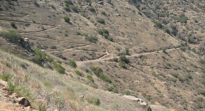
The zigzag trail ends at the old Flume Trail
Although the 88-acre El Monte County Park was one of the first areas set aside for a park in the county, it was not until February 2011 that an official trail to East County’s landmark El Cajon Mountain was opened to the public in El Monte Valley. El Cajon Mountain is also known as El Capitan because of its resemblance to the face of Yosemite’s famous landmark. On the north side of El Monte Road, the rocky face of El Cajon Mountain glistens over a pastoral scene of green grass, coast live oaks, other shade trees, and picnic areas. There may be sightings of a resident heron, wild turkeys, and mule deer that come in to feed on the grass.
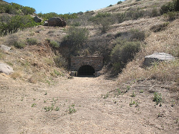
El Monte Flume Tunnel installed by SD Flume Co. in late 1800s
Many have mistakenly identified the trail beginning in El Monte County Park as the “Flume Trail.” It is actually the El Monte Park Trail that climbs the ridge to meet the Flume Trail, which crosses it. The El Monte Park Trail ends where it meets the Flume Trail on the ridge. The route after crossing the Flume Trail is called the Valley View Community Trail, which begins at the Flume Trail crossing and ends at Creek Hills Road in Blossom Valley. The El Monte County Park portion of the Flume Trail follows the ridge east for 1 mile and 1.5 miles to the west, where it ends at a fence and private property begins.
The trails are subtly marked with the El Monte Park/Blossom Valley trailhead at the edge of a fence near picnic area #8 at the far side of the park. The first 0.6 mile of the narrow trail has an initial climb of about 1100 feet and then descends to a trail intersection. On the way down, look to the left of the trail where there is a flume grade, a historic feature of the trail. Hidden between the two hillsides is an old tunnel that is a remnant of a flume installed by the San Diego Flume Company in the late 1800s. The tunnel is closed, but it invites a look through to the other end via openings that a camera lens can fit.
At the trail intersection, the options include returning directly to the starting point or continuing to ascend south on the Valley View Community trail for another 1200 feet before descending to Creek Hills Road in Blossom Valley. This combination will give the best workout over the many steep switchbacks that look like they were carved into the mountainside. The top of the ridge offers panoramic views of homes, ranches, and orchards in the valley below. Earlier in history, this valley was a homeland for bands of the Kumeyaay Indian nation.
Another hike option is to go west on the Flume Trail, a wide, somewhat-level trail running both east and west. Going west, the trail leads about 1.5 miles toward Lake Jennings, where there is interpretive information about the San Diego flume. Look off to the western side of the trail to see large animal-like rock formations. The last hike option is to go east for a mile. Return to the trail intersection to finish the hike and descend north to the parking area where a rest under the trees is well earned.
Many native plants are clustered along the north-facing cliff of the Flume Trail. California buckwheat, laurel sumac, white sage, southern wild cucumber, and, unfortunately, the invasive black mustard are predominant in the area. Toyon, San Diego monkey flower, and California poppy also cling to the slope. In shady areas there is an abundance of mushrooms, moss, fern, lichen, poison oak, basket bush, and chalk dudleya. San Diego morning-glory dot the scene along with the purple chia, caterpillar and Parry’s phacelia, Parry’s larkspur, and the bright red of the southern pink flower. Possible wildlife sightings include a coyote that may run across the trail and up into the hills or lizards and birds that pop in and out of the chaparral. Easier to see are crows and hummingbirds that do not bother to hide from hikers.
EL MONTE COUNTY PARK
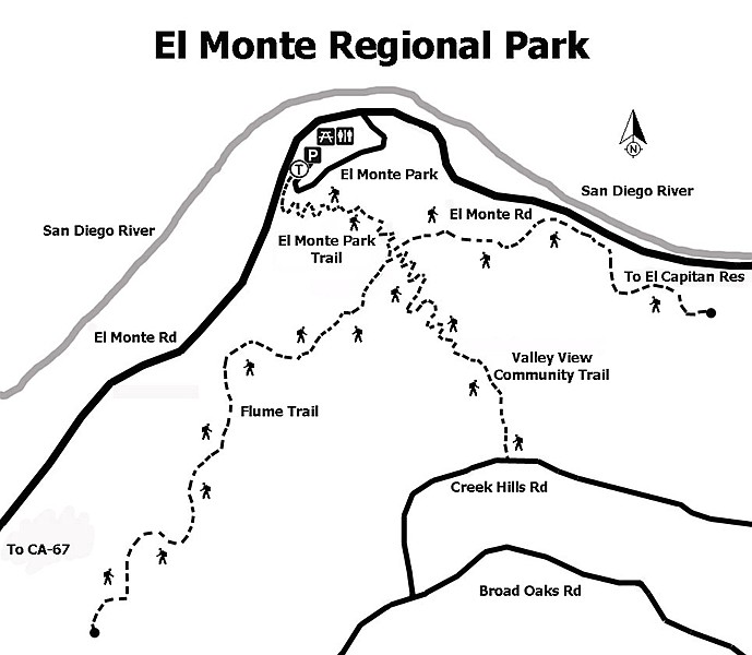
El Monte Regional Park trail map
Distance from downtown San Diego: About 30 miles. Allow 40 minutes driving time (Lakeside). Take I-8 E and exit at Lake Jennings Park Rd. Go north on Lake Jennings Park Rd. 1.5 miles to El Monte Rd. and turn right (east). Drive 6 miles east to the park entrance. Pay a day-use fee for parking/picnicking at the county park or park for free in the equestrian staging area across El Monte Rd. Open 9:30 a.m. to sunset. Closed Christmas day.
Hiking length: 2 to 8 miles, round trip, depending on options.
Difficulty: Moderately strenuous because of elevation changes and switchbacks. Elevation gain/loss 1200 feet. Equestrians, bicycles and dogs (on leashes) allowed. Facilities and water. Hike early morning or when the temperature is cooler. The trail is slippery after a rain. “Keep out” signs delineate private property and habitat protection areas.
Here's something you might be interested in.
Views of homes and ranches where Kumeyaay once lived
Follow a zigzag trail to a view point that ends at the old Flume Trail.
Views of homes and ranches where Kumeyaay once lived
Follow a zigzag trail to a view point that ends at the old Flume Trail.
The zigzag trail ends at the old Flume Trail
Although the 88-acre El Monte County Park was one of the first areas set aside for a park in the county, it was not until February 2011 that an official trail to East County’s landmark El Cajon Mountain was opened to the public in El Monte Valley. El Cajon Mountain is also known as El Capitan because of its resemblance to the face of Yosemite’s famous landmark. On the north side of El Monte Road, the rocky face of El Cajon Mountain glistens over a pastoral scene of green grass, coast live oaks, other shade trees, and picnic areas. There may be sightings of a resident heron, wild turkeys, and mule deer that come in to feed on the grass.
El Monte Flume Tunnel installed by SD Flume Co. in late 1800s
Many have mistakenly identified the trail beginning in El Monte County Park as the “Flume Trail.” It is actually the El Monte Park Trail that climbs the ridge to meet the Flume Trail, which crosses it. The El Monte Park Trail ends where it meets the Flume Trail on the ridge. The route after crossing the Flume Trail is called the Valley View Community Trail, which begins at the Flume Trail crossing and ends at Creek Hills Road in Blossom Valley. The El Monte County Park portion of the Flume Trail follows the ridge east for 1 mile and 1.5 miles to the west, where it ends at a fence and private property begins.
The trails are subtly marked with the El Monte Park/Blossom Valley trailhead at the edge of a fence near picnic area #8 at the far side of the park. The first 0.6 mile of the narrow trail has an initial climb of about 1100 feet and then descends to a trail intersection. On the way down, look to the left of the trail where there is a flume grade, a historic feature of the trail. Hidden between the two hillsides is an old tunnel that is a remnant of a flume installed by the San Diego Flume Company in the late 1800s. The tunnel is closed, but it invites a look through to the other end via openings that a camera lens can fit.
At the trail intersection, the options include returning directly to the starting point or continuing to ascend south on the Valley View Community trail for another 1200 feet before descending to Creek Hills Road in Blossom Valley. This combination will give the best workout over the many steep switchbacks that look like they were carved into the mountainside. The top of the ridge offers panoramic views of homes, ranches, and orchards in the valley below. Earlier in history, this valley was a homeland for bands of the Kumeyaay Indian nation.
Another hike option is to go west on the Flume Trail, a wide, somewhat-level trail running both east and west. Going west, the trail leads about 1.5 miles toward Lake Jennings, where there is interpretive information about the San Diego flume. Look off to the western side of the trail to see large animal-like rock formations. The last hike option is to go east for a mile. Return to the trail intersection to finish the hike and descend north to the parking area where a rest under the trees is well earned.
Many native plants are clustered along the north-facing cliff of the Flume Trail. California buckwheat, laurel sumac, white sage, southern wild cucumber, and, unfortunately, the invasive black mustard are predominant in the area. Toyon, San Diego monkey flower, and California poppy also cling to the slope. In shady areas there is an abundance of mushrooms, moss, fern, lichen, poison oak, basket bush, and chalk dudleya. San Diego morning-glory dot the scene along with the purple chia, caterpillar and Parry’s phacelia, Parry’s larkspur, and the bright red of the southern pink flower. Possible wildlife sightings include a coyote that may run across the trail and up into the hills or lizards and birds that pop in and out of the chaparral. Easier to see are crows and hummingbirds that do not bother to hide from hikers.
EL MONTE COUNTY PARK
El Monte Regional Park trail map
Distance from downtown San Diego: About 30 miles. Allow 40 minutes driving time (Lakeside). Take I-8 E and exit at Lake Jennings Park Rd. Go north on Lake Jennings Park Rd. 1.5 miles to El Monte Rd. and turn right (east). Drive 6 miles east to the park entrance. Pay a day-use fee for parking/picnicking at the county park or park for free in the equestrian staging area across El Monte Rd. Open 9:30 a.m. to sunset. Closed Christmas day.
Hiking length: 2 to 8 miles, round trip, depending on options.
Difficulty: Moderately strenuous because of elevation changes and switchbacks. Elevation gain/loss 1200 feet. Equestrians, bicycles and dogs (on leashes) allowed. Facilities and water. Hike early morning or when the temperature is cooler. The trail is slippery after a rain. “Keep out” signs delineate private property and habitat protection areas.
Comments