Here's something you might be interested in.
Ask a Hipster — Advice you didn't know you needed
Big Screen — Movie commentary
Blurt — Music's inside track
Booze News — San Diego spirits
Classical Music — Immortal beauty
Classifieds — Free and easy
Close to Home — What it’s like on the street where you live
Cover Stories — Front-page features
Drinks All Around — Bartenders' drink recipes
Excerpts — Literary and spiritual excerpts
Feast! — Food & drink reviews
Feature Stories — Local news & stories
Fishing Report — What’s getting hooked from ship and shore
From the Archives — Spotlight on the past
Golden Dreams — Talk of the town
The Gonzo Report — Making the musical scene, or at least reporting from it
Letters — Our inbox
Movies@Home — Local movie buffs share favorites
Movie Reviews — Our critics' picks and pans
Musician Interviews — Up close with local artists
Neighborhood News from Stringers — Hyperlocal news
News Ticker — News & politics
Obermeyer — San Diego politics illustrated
Outdoors — Weekly changes in flora and fauna
Overheard in San Diego — Eavesdropping illustrated
Poetry — The old and the new
Reader Travel — Travel section built by travelers
Reading — The hunt for intellectuals
Roam-O-Rama — SoCal's best hiking/biking trails
San Diego Beer — Inside San Diego suds
SD on the QT — Almost factual news
Sheep and Goats — Places of worship
Special Issues — The best of
Street Style — San Diego streets have style
Surf Diego — Real stories from those braving the waves
Theater — On stage in San Diego this week
Tin Fork — Silver spoon alternative
Under the Radar — Matt Potter's undercover work
Unforgettable — Long-ago San Diego
Unreal Estate — San Diego's priciest pads
Your Week — Daily event picks
Mind the endangered species on McGinty Mountain
Uncommon soils make for rare plants along this trail
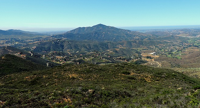
On a clear day, one can see the Pacific from McGinty Mountain.
McGinty Mountain lies within a collective ecological preserve managed by the Nature Conservancy, the California Department of Fish and Wildlife, and the U.S. Fish and Wildlife Service’s San Diego National Wildlife Refuge. Several rare and endangered plant species make their home here on a relatively uncommon type of soil known as gabbro. These soils occur in fault zones, primarily in the Coast Range of California and the western Sierra Nevada foothills. They are characterized by having low levels of nitrogen, phosphorus, and potassium, the major nutrients required by plants. In addition, they contain high levels of iron and heavy metals such as nickel, chromium, and cobalt, which are toxic to most plants.
The trailhead leaves from the rear of the parking lot next to the refuge kiosk that contains useful information about the area. The view from the lot may look short and easy to the peak, as the summit does not seem that far away. In actuality, you are looking up at a bluff that is acting as a false summit and is far from the final destination. The first segment of the trail starts out as a wide road, but at 0.25 mile it bears right and becomes a single-track switchback trail. This is a good area to begin a lookout for rare plants.
The endemic (limited to a particular locality) San Diego thornmint (Acanthomintha ilicifolia) is a small annual herb found only in southwestern San Diego County and in northern Baja California in openings of coastal sage scrub, chaparral, or grasslands, where there is gabbro or calcareous soils. Look for small white flowers often tinted purple or pink that bloom in April through June. A member of the mint family, the plant’s habitat has been reduced by nearly 90 percent during the past century by urbanization and is listed as a threatened species under the California Endangered Species Act. Another find may be San Miguel savory (Clinopodium chandleri), an especially rare native in California, listed by the California Native Plant Society as endangered in our state. It is an aromatic low shrub with small white flowers that appear in the spring and summer. Its leaves have a smell like mint, which is one of its relatives. Also in the area is the similarly rare Parry’s tetracoccus (Tetracoccus dioicus), a shrub with springtime clusters of small red flowers found within the chaparral plant community. It has a distinct four-lobed fruit.
After about 0.5 mile of chaparral-lined trail and some elevation gain, the trail is at the false summit seen from below. The correct trail will now ascend to the north. Do not take the path going south and downhill toward Jamul, as it crosses onto private property. However, before continuing the uphill climb to the summit, investigate the area for the remains of an old mine. In the early 1900s, silicified alaskite aplite was mined for use in porcelain-ware manufacturing. Alaskite is a general term for rocks consisting essentially of quartz and alkali feldspar without regard to texture. Aplites at this location are fine-grained “sugary” textured white rocks. Look for rocks on the grounds that are characterized by the absence or scarcity of dark-colored minerals that have a granular habit. Several other mines can be seen along the way but this is the only one readily visible. Do not enter any mine openings, as they are unsafe (danger of collapse, vertical shafts that you could fall into, noxious gas) and their cool recesses are a favorite haunt for rattlesnakes during the heat of the day.\
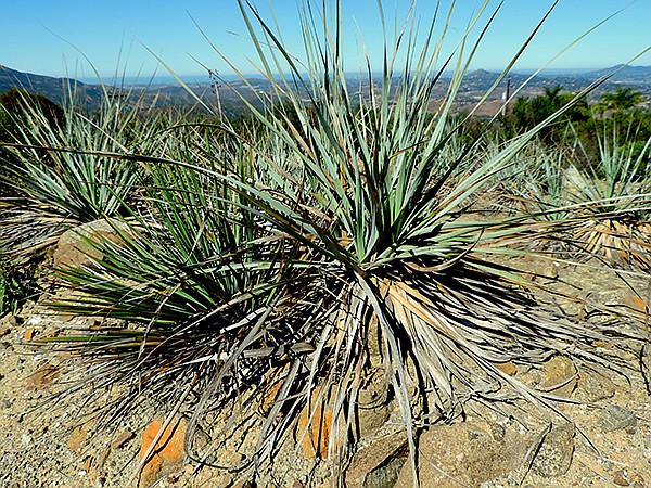
Dehesa beargrass
After continuing northward 0.1 mile, the trail will crest the bluff and for the first time, the 2183-foot summit of McGinty Mountain can be seen, another 1.5 miles ahead. Look for Dehesa beargrass (Nolina interrata) on the way to the summit. With its showy blue-gray foliage, it roughly resembles another member of the agave family — the far more common chaparral candle, though it does not have the same supportive structure. Over half of California’s remaining 9000 specimens of Dehesa beargrass are found along McGinty’s ridgeline. Be sure to note the many less-traveled trails branching off the main trail so you can find the proper path on your way back down. Atop the summit you will have views of most of eastern San Diego County and many of the county’s peaks, such as Cowles, North Fortuna, Otay, Jamul, Lyons, Tecate, El Capitan, and Viejas, and on a clear day you can see the Pacific Ocean. Once taking a rest on the summit, return the same way to the parking lot.
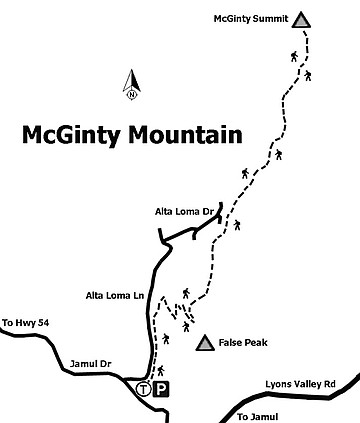
Trail to McGinty Summit
MCGINTY MOUNTAIN
Distance from downtown San Diego: 20.5 miles. Allow 30 minutes driving time (Jamul). Take SR-94 E and continue on SR-94 E/Campo Rd. to Lyons Valley Rd. and turn left (northeast). Turn left (northwest) onto Jamul Dr. Trailhead parking is 0.4 mile on the right.
Hiking Length: 4.7 miles.
Difficulty: Strenuous, with 1300 feet of elevation gain/loss. Dogs (on leashes) allowed. Stay on the trail, as the system is within a series of easements from both private and public lands. No facilities.
Here's something you might be interested in.
Mind the endangered species on McGinty Mountain
Uncommon soils make for rare plants along this trail
Mind the endangered species on McGinty Mountain
Uncommon soils make for rare plants along this trail
On a clear day, one can see the Pacific from McGinty Mountain.
McGinty Mountain lies within a collective ecological preserve managed by the Nature Conservancy, the California Department of Fish and Wildlife, and the U.S. Fish and Wildlife Service’s San Diego National Wildlife Refuge. Several rare and endangered plant species make their home here on a relatively uncommon type of soil known as gabbro. These soils occur in fault zones, primarily in the Coast Range of California and the western Sierra Nevada foothills. They are characterized by having low levels of nitrogen, phosphorus, and potassium, the major nutrients required by plants. In addition, they contain high levels of iron and heavy metals such as nickel, chromium, and cobalt, which are toxic to most plants.
The trailhead leaves from the rear of the parking lot next to the refuge kiosk that contains useful information about the area. The view from the lot may look short and easy to the peak, as the summit does not seem that far away. In actuality, you are looking up at a bluff that is acting as a false summit and is far from the final destination. The first segment of the trail starts out as a wide road, but at 0.25 mile it bears right and becomes a single-track switchback trail. This is a good area to begin a lookout for rare plants.
The endemic (limited to a particular locality) San Diego thornmint (Acanthomintha ilicifolia) is a small annual herb found only in southwestern San Diego County and in northern Baja California in openings of coastal sage scrub, chaparral, or grasslands, where there is gabbro or calcareous soils. Look for small white flowers often tinted purple or pink that bloom in April through June. A member of the mint family, the plant’s habitat has been reduced by nearly 90 percent during the past century by urbanization and is listed as a threatened species under the California Endangered Species Act. Another find may be San Miguel savory (Clinopodium chandleri), an especially rare native in California, listed by the California Native Plant Society as endangered in our state. It is an aromatic low shrub with small white flowers that appear in the spring and summer. Its leaves have a smell like mint, which is one of its relatives. Also in the area is the similarly rare Parry’s tetracoccus (Tetracoccus dioicus), a shrub with springtime clusters of small red flowers found within the chaparral plant community. It has a distinct four-lobed fruit.
After about 0.5 mile of chaparral-lined trail and some elevation gain, the trail is at the false summit seen from below. The correct trail will now ascend to the north. Do not take the path going south and downhill toward Jamul, as it crosses onto private property. However, before continuing the uphill climb to the summit, investigate the area for the remains of an old mine. In the early 1900s, silicified alaskite aplite was mined for use in porcelain-ware manufacturing. Alaskite is a general term for rocks consisting essentially of quartz and alkali feldspar without regard to texture. Aplites at this location are fine-grained “sugary” textured white rocks. Look for rocks on the grounds that are characterized by the absence or scarcity of dark-colored minerals that have a granular habit. Several other mines can be seen along the way but this is the only one readily visible. Do not enter any mine openings, as they are unsafe (danger of collapse, vertical shafts that you could fall into, noxious gas) and their cool recesses are a favorite haunt for rattlesnakes during the heat of the day.\
Dehesa beargrass
After continuing northward 0.1 mile, the trail will crest the bluff and for the first time, the 2183-foot summit of McGinty Mountain can be seen, another 1.5 miles ahead. Look for Dehesa beargrass (Nolina interrata) on the way to the summit. With its showy blue-gray foliage, it roughly resembles another member of the agave family — the far more common chaparral candle, though it does not have the same supportive structure. Over half of California’s remaining 9000 specimens of Dehesa beargrass are found along McGinty’s ridgeline. Be sure to note the many less-traveled trails branching off the main trail so you can find the proper path on your way back down. Atop the summit you will have views of most of eastern San Diego County and many of the county’s peaks, such as Cowles, North Fortuna, Otay, Jamul, Lyons, Tecate, El Capitan, and Viejas, and on a clear day you can see the Pacific Ocean. Once taking a rest on the summit, return the same way to the parking lot.
Trail to McGinty Summit
MCGINTY MOUNTAIN
Distance from downtown San Diego: 20.5 miles. Allow 30 minutes driving time (Jamul). Take SR-94 E and continue on SR-94 E/Campo Rd. to Lyons Valley Rd. and turn left (northeast). Turn left (northwest) onto Jamul Dr. Trailhead parking is 0.4 mile on the right.
Hiking Length: 4.7 miles.
Difficulty: Strenuous, with 1300 feet of elevation gain/loss. Dogs (on leashes) allowed. Stay on the trail, as the system is within a series of easements from both private and public lands. No facilities.
Comments