Here's something you might be interested in.
Ask a Hipster — Advice you didn't know you needed
Big Screen — Movie commentary
Blurt — Music's inside track
Booze News — San Diego spirits
Classical Music — Immortal beauty
Classifieds — Free and easy
Close to Home — What it’s like on the street where you live
Cover Stories — Front-page features
Drinks All Around — Bartenders' drink recipes
Excerpts — Literary and spiritual excerpts
Feast! — Food & drink reviews
Feature Stories — Local news & stories
Fishing Report — What’s getting hooked from ship and shore
From the Archives — Spotlight on the past
Golden Dreams — Talk of the town
The Gonzo Report — Making the musical scene, or at least reporting from it
Letters — Our inbox
Movies@Home — Local movie buffs share favorites
Movie Reviews — Our critics' picks and pans
Musician Interviews — Up close with local artists
Neighborhood News from Stringers — Hyperlocal news
News Ticker — News & politics
Obermeyer — San Diego politics illustrated
Outdoors — Weekly changes in flora and fauna
Overheard in San Diego — Eavesdropping illustrated
Poetry — The old and the new
Reader Travel — Travel section built by travelers
Reading — The hunt for intellectuals
Roam-O-Rama — SoCal's best hiking/biking trails
San Diego Beer — Inside San Diego suds
SD on the QT — Almost factual news
Sheep and Goats — Places of worship
Special Issues — The best of
Street Style — San Diego streets have style
Surf Diego — Real stories from those braving the waves
Theater — On stage in San Diego this week
Tin Fork — Silver spoon alternative
Under the Radar — Matt Potter's undercover work
Unforgettable — Long-ago San Diego
Unreal Estate — San Diego's priciest pads
Your Week — Daily event picks
More '60s homes in Del Cerro
Future residents stuck going north on College Avenue
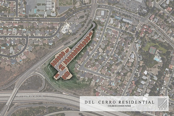
ColRich aerial map
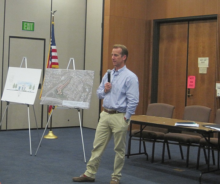
Tony Pauker
Traffic was the primary concern of residents attending a July 23 presentation about a proposal to build 26 single-family homes on a 5.6-acre vacant site located south of the Del Cerro Boulevard/College Avenue intersection and north of westbound Interstate 8. About 100 people attended the Del Cerro Action Council meeting where Tony Pauker, vice president of acquisitions for San Diego-based ColRich, Inc. spoke about the project that would have only one entrance/exit.
As Pauker answered questions at Temple Emanu-El, other people spoke, and it was sometimes difficult to hear. I contacted him on July 24 to clarify details. Furthermore, people didn't give their names during or after the meeting.
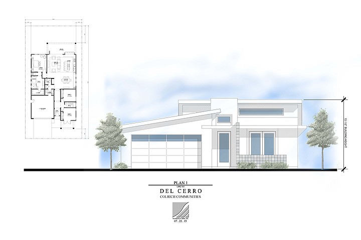
ColRich design plan 1
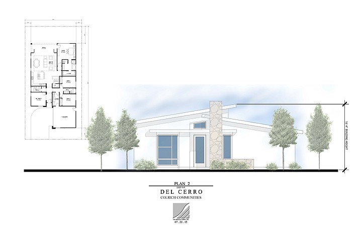
ColRich design plan 2
Large windows, flat roofs
The "largely one-story" homes priced in the "high $600,000s" will be built on 5000-square-foot lots. The three-bedroom, three-bathroom homes will be 1800, 2000, or 2275 square feet. The design "concept is based on the mid-1960s architecture of the surrounding homes with large windows, open floor plans, flat and shallow-pitched roofs, and large windows," said Pauker.
He described a timeline that included submitting a tentative map to the city a week and half earlier.
Chevron patrons turn illegally
Chevron station at 6301 Del Cerro Blvd.
Project access would be on College Avenue, about 100 to 150 feet south of the Chevron station on the southeast corner of Del Cerro Boulevard and College. There are plans for a deceleration/acceleration lane on the property, and the right-turn lane from College to eastbound Del Cerro Boulevard will be lengthened. Drivers can only leave or enter the property by turning right on College.
U-turns aren't allowed at the Del Cerro Boulevard signal. However, residents say some Chevron patrons make illegal turns and endanger others. Residents maintain development drivers may also turn illegally.
That issue was also raised when Pauker spoke at the July 8 Navajo Community Planners, Inc., meeting. At both forums, he said illegal turns were a police-enforcement issue. He said the City of San Diego requires a traffic study when a development will generate 500 daily trips. Although the ColRich projection is 260 trips, the developer is doing a traffic study.
No U-turns until Waring Road
Pauker said the scope would be expanded to six intersections. When I asked which intersections, Pauker responded, "That will be determined by the traffic engineer," with intersections to the "north, south, east, and west."
At the Del Cerro meeting, he said U-turns weren't allowed for southbound drivers until College turned into Waring Road in Allied Gardens. A woman asked if the study would look at school-related traffic. Before he answered, another woman said the Einstein Brothers Bagels (the northeast corner of College and Del Cerro Boulevard) "doubles the traffic" in the morning.
Marburn Corp. from Toronto owns the land
Pauker said the city requires studies during the school year and summer.
A woman asked how residents would return from Phoebe Heart Elementary School, which is west of the College/Del Cerro Boulevard intersection. Pauker said by driving south of College to El Cajon Boulevard. "Oh my God," another woman said as he described a freeway route.
Land south of Chevron. Despite what sign says, Pauker said land is not for sale.
Later, someone asked who owned the land. "Marburn Corporation," said Pauker. At the earlier meeting, he said the owners were in Toronto. Websites including California Corporates showed Marburn incorporated in 1975, has a San Diego agent, and Toronto address.
A man referred to a previous owner's plan to build duplexes on the site during the 1970s.
Will they become SDSU mini-dorms?
People asked when they could comment on the project. He said documents were public, and he would return to the planning group with updates.
The woman who spoke about Einstein traffic said, "We can go to the city as a group."
After the meeting, a man distributed a yellow handout with reasons the development "should not proceed." The reasons (also cited in the meeting) included construction noise and concern that the homes across the freeway from San Diego State University would become mini-dorms.
Other people spoke about taking their objections to 7th District city councilman Scott Sherman.
Here's something you might be interested in.
More '60s homes in Del Cerro
Future residents stuck going north on College Avenue
More '60s homes in Del Cerro
Future residents stuck going north on College Avenue
ColRich aerial map
Tony Pauker
Traffic was the primary concern of residents attending a July 23 presentation about a proposal to build 26 single-family homes on a 5.6-acre vacant site located south of the Del Cerro Boulevard/College Avenue intersection and north of westbound Interstate 8. About 100 people attended the Del Cerro Action Council meeting where Tony Pauker, vice president of acquisitions for San Diego-based ColRich, Inc. spoke about the project that would have only one entrance/exit.
As Pauker answered questions at Temple Emanu-El, other people spoke, and it was sometimes difficult to hear. I contacted him on July 24 to clarify details. Furthermore, people didn't give their names during or after the meeting.
ColRich design plan 1
ColRich design plan 2
Large windows, flat roofs
The "largely one-story" homes priced in the "high $600,000s" will be built on 5000-square-foot lots. The three-bedroom, three-bathroom homes will be 1800, 2000, or 2275 square feet. The design "concept is based on the mid-1960s architecture of the surrounding homes with large windows, open floor plans, flat and shallow-pitched roofs, and large windows," said Pauker.
He described a timeline that included submitting a tentative map to the city a week and half earlier.
Chevron patrons turn illegally
Chevron station at 6301 Del Cerro Blvd.
Project access would be on College Avenue, about 100 to 150 feet south of the Chevron station on the southeast corner of Del Cerro Boulevard and College. There are plans for a deceleration/acceleration lane on the property, and the right-turn lane from College to eastbound Del Cerro Boulevard will be lengthened. Drivers can only leave or enter the property by turning right on College.
U-turns aren't allowed at the Del Cerro Boulevard signal. However, residents say some Chevron patrons make illegal turns and endanger others. Residents maintain development drivers may also turn illegally.
That issue was also raised when Pauker spoke at the July 8 Navajo Community Planners, Inc., meeting. At both forums, he said illegal turns were a police-enforcement issue. He said the City of San Diego requires a traffic study when a development will generate 500 daily trips. Although the ColRich projection is 260 trips, the developer is doing a traffic study.
No U-turns until Waring Road
Pauker said the scope would be expanded to six intersections. When I asked which intersections, Pauker responded, "That will be determined by the traffic engineer," with intersections to the "north, south, east, and west."
At the Del Cerro meeting, he said U-turns weren't allowed for southbound drivers until College turned into Waring Road in Allied Gardens. A woman asked if the study would look at school-related traffic. Before he answered, another woman said the Einstein Brothers Bagels (the northeast corner of College and Del Cerro Boulevard) "doubles the traffic" in the morning.
Marburn Corp. from Toronto owns the land
Pauker said the city requires studies during the school year and summer.
A woman asked how residents would return from Phoebe Heart Elementary School, which is west of the College/Del Cerro Boulevard intersection. Pauker said by driving south of College to El Cajon Boulevard. "Oh my God," another woman said as he described a freeway route.
Land south of Chevron. Despite what sign says, Pauker said land is not for sale.
Later, someone asked who owned the land. "Marburn Corporation," said Pauker. At the earlier meeting, he said the owners were in Toronto. Websites including California Corporates showed Marburn incorporated in 1975, has a San Diego agent, and Toronto address.
A man referred to a previous owner's plan to build duplexes on the site during the 1970s.
Will they become SDSU mini-dorms?
People asked when they could comment on the project. He said documents were public, and he would return to the planning group with updates.
The woman who spoke about Einstein traffic said, "We can go to the city as a group."
After the meeting, a man distributed a yellow handout with reasons the development "should not proceed." The reasons (also cited in the meeting) included construction noise and concern that the homes across the freeway from San Diego State University would become mini-dorms.
Other people spoke about taking their objections to 7th District city councilman Scott Sherman.
Comments