Here's something you might be interested in.
Ask a Hipster — Advice you didn't know you needed
Big Screen — Movie commentary
Blurt — Music's inside track
Booze News — San Diego spirits
Classical Music — Immortal beauty
Classifieds — Free and easy
Close to Home — What it’s like on the street where you live
Cover Stories — Front-page features
Drinks All Around — Bartenders' drink recipes
Excerpts — Literary and spiritual excerpts
Feast! — Food & drink reviews
Feature Stories — Local news & stories
Fishing Report — What’s getting hooked from ship and shore
From the Archives — Spotlight on the past
Golden Dreams — Talk of the town
The Gonzo Report — Making the musical scene, or at least reporting from it
Letters — Our inbox
Movies@Home — Local movie buffs share favorites
Movie Reviews — Our critics' picks and pans
Musician Interviews — Up close with local artists
Neighborhood News from Stringers — Hyperlocal news
News Ticker — News & politics
Obermeyer — San Diego politics illustrated
Outdoors — Weekly changes in flora and fauna
Overheard in San Diego — Eavesdropping illustrated
Poetry — The old and the new
Reader Travel — Travel section built by travelers
Reading — The hunt for intellectuals
Roam-O-Rama — SoCal's best hiking/biking trails
San Diego Beer — Inside San Diego suds
SD on the QT — Almost factual news
Sheep and Goats — Places of worship
Special Issues — The best of
Street Style — San Diego streets have style
Surf Diego — Real stories from those braving the waves
Theater — On stage in San Diego this week
Tin Fork — Silver spoon alternative
Under the Radar — Matt Potter's undercover work
Unforgettable — Long-ago San Diego
Unreal Estate — San Diego's priciest pads
Your Week — Daily event picks
Walk the river
Stroll through tree-shaded walkways in Mission Valley
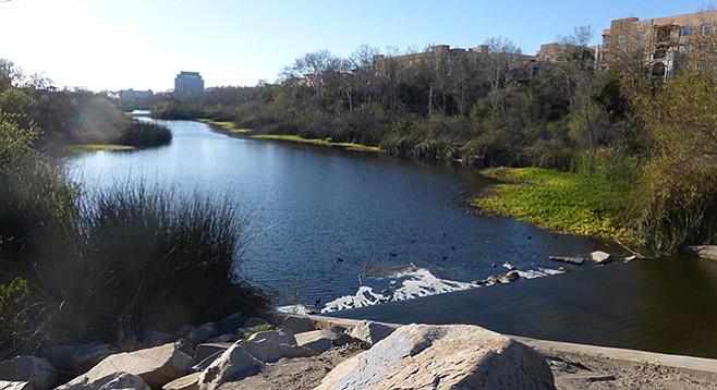
Walk along the San Diego River
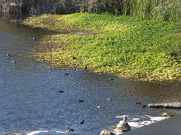
A great place to observe waterfowl
Although located in the midst of metropolitan San Diego, this trail segment meanders along a lush wooded watercourse that winds its way to the Pacific Ocean. It is part of the San Diego River Park network of paths found along the San Diego River channel that extends from Volcan Mountain until the river flows into the ocean at Mission Bay for a distance of 52 miles. This river was used by the Kumeyaay, then later as a water source for Mission San Diego de Alcalá, 19th-century European settlers, and currently serves the City of San Diego through San Vicente and El Capitan reservoirs.
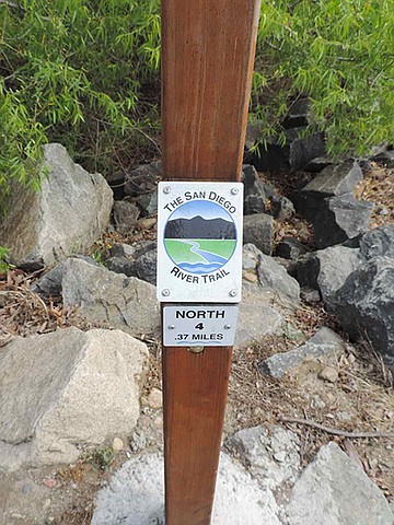
Mile markers measure your progress along the trail
There is a kiosk that gives a brief overview of the area, including a map and a description of plants and animals found along the trail. Toyon, also called Christmas berry due to its bright red winter berries, lemonade berry with pink buds, and elderberry with its bluish-black berries, provide food for wildlife. The river in this area shows a history of flooding since record-keeping began in 1914. The biggest recorded flood occurred in January of 1916, when the river grew to be a mile wide with a flow rate of 70,200 cubic feet of water per second, damaging roads, tracks, and telephone/telegraph lines that took over a month to repair.
The walk begins at North Marker 4 at the entrance of the parking lot. Look for American coots, ducks, and gulls that splash and feed down the banks and islands in the river. Along the path are native plants, such as rushes, mule fat, coyote bush, white patchy sycamore trees, and coast live oaks.
At North Marker 5, the river view opens looking south. Native pink roses (Rosa californica) and sunflowers (Encelia californica) line the river pathway. Their blooms foretell the approach of spring. Hidden is the wrentit, a tiny native brown bird with the “call of the chaparral.” Other birds to be seen include black phoebes, bushtits, and white-crowned sparrows, peeking out from the bushes. Laurel sumac, an indicator plant of a frost-free area, provides shelter.
Along the trail, near North Marker 6, is an overlook for observing the river life. Note the arroyo willow nearby. It was revered by the Kumeyaay for its medicinal properties as a pain reliever, source of basket material, and used for making clothing. Benches near the kiosk welcome weary travelers.
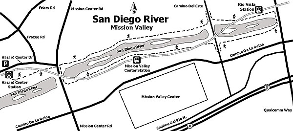
San Diego River Trail
To continue east along the river, turn north on Camino del Estes for a short distance to a crosswalk, carefully cross the street, then immediately turn south back down to the river and turn east on the path until Qualcomm Way. The path turns south and crosses over the San Diego River at Qualcomm Way. Looking westward, the river eventually empties into the ocean between Mission Beach and Ocean Beach via an estuary.
Turning west, the path runs parallel to the trolley tracks. Passengers on the trolley have a fabulous view of the river as they speed along the line. There are benches and picnic tables along the trail. Native sugar bush (not usually found at this low of an elevation) is a reminder that banks of the river have been replanted after the channel was straightened. Following the path west to the end, turn north and return to your car or trolley station.
Distance from downtown San Diego: 5 miles. Allow 15 minutes driving time (Mission Valley). From SR-163, exit east on Friars Rd. Turn south on Frazee Rd. then west on Hazard Center Dr. and park in the lot. Or, take the Green Line Trolley to Hazard Station, walk 0.2 mile east to the parking lot at Mission Center Dr. and Hazard Center Dr., taking care when crossing the road.
Hiking length: 2-mile loop.
Difficulty: Easy. Pavement is flat and wide with leashed dogs, bicyclists, and joggers common. No facilities at the parking lot, with stores and restaurants on the south side of the River Walk.
Here's something you might be interested in.
Walk the river
Stroll through tree-shaded walkways in Mission Valley
Walk the river
Stroll through tree-shaded walkways in Mission Valley
Walk along the San Diego River
A great place to observe waterfowl
Although located in the midst of metropolitan San Diego, this trail segment meanders along a lush wooded watercourse that winds its way to the Pacific Ocean. It is part of the San Diego River Park network of paths found along the San Diego River channel that extends from Volcan Mountain until the river flows into the ocean at Mission Bay for a distance of 52 miles. This river was used by the Kumeyaay, then later as a water source for Mission San Diego de Alcalá, 19th-century European settlers, and currently serves the City of San Diego through San Vicente and El Capitan reservoirs.
Mile markers measure your progress along the trail
There is a kiosk that gives a brief overview of the area, including a map and a description of plants and animals found along the trail. Toyon, also called Christmas berry due to its bright red winter berries, lemonade berry with pink buds, and elderberry with its bluish-black berries, provide food for wildlife. The river in this area shows a history of flooding since record-keeping began in 1914. The biggest recorded flood occurred in January of 1916, when the river grew to be a mile wide with a flow rate of 70,200 cubic feet of water per second, damaging roads, tracks, and telephone/telegraph lines that took over a month to repair.
The walk begins at North Marker 4 at the entrance of the parking lot. Look for American coots, ducks, and gulls that splash and feed down the banks and islands in the river. Along the path are native plants, such as rushes, mule fat, coyote bush, white patchy sycamore trees, and coast live oaks.
At North Marker 5, the river view opens looking south. Native pink roses (Rosa californica) and sunflowers (Encelia californica) line the river pathway. Their blooms foretell the approach of spring. Hidden is the wrentit, a tiny native brown bird with the “call of the chaparral.” Other birds to be seen include black phoebes, bushtits, and white-crowned sparrows, peeking out from the bushes. Laurel sumac, an indicator plant of a frost-free area, provides shelter.
Along the trail, near North Marker 6, is an overlook for observing the river life. Note the arroyo willow nearby. It was revered by the Kumeyaay for its medicinal properties as a pain reliever, source of basket material, and used for making clothing. Benches near the kiosk welcome weary travelers.
San Diego River Trail
To continue east along the river, turn north on Camino del Estes for a short distance to a crosswalk, carefully cross the street, then immediately turn south back down to the river and turn east on the path until Qualcomm Way. The path turns south and crosses over the San Diego River at Qualcomm Way. Looking westward, the river eventually empties into the ocean between Mission Beach and Ocean Beach via an estuary.
Turning west, the path runs parallel to the trolley tracks. Passengers on the trolley have a fabulous view of the river as they speed along the line. There are benches and picnic tables along the trail. Native sugar bush (not usually found at this low of an elevation) is a reminder that banks of the river have been replanted after the channel was straightened. Following the path west to the end, turn north and return to your car or trolley station.
Distance from downtown San Diego: 5 miles. Allow 15 minutes driving time (Mission Valley). From SR-163, exit east on Friars Rd. Turn south on Frazee Rd. then west on Hazard Center Dr. and park in the lot. Or, take the Green Line Trolley to Hazard Station, walk 0.2 mile east to the parking lot at Mission Center Dr. and Hazard Center Dr., taking care when crossing the road.
Hiking length: 2-mile loop.
Difficulty: Easy. Pavement is flat and wide with leashed dogs, bicyclists, and joggers common. No facilities at the parking lot, with stores and restaurants on the south side of the River Walk.