Here's something you might be interested in.
Ask a Hipster — Advice you didn't know you needed
Big Screen — Movie commentary
Blurt — Music's inside track
Booze News — San Diego spirits
Classical Music — Immortal beauty
Classifieds — Free and easy
Close to Home — What it’s like on the street where you live
Cover Stories — Front-page features
Drinks All Around — Bartenders' drink recipes
Excerpts — Literary and spiritual excerpts
Feast! — Food & drink reviews
Feature Stories — Local news & stories
Fishing Report — What’s getting hooked from ship and shore
From the Archives — Spotlight on the past
Golden Dreams — Talk of the town
The Gonzo Report — Making the musical scene, or at least reporting from it
Letters — Our inbox
Movies@Home — Local movie buffs share favorites
Movie Reviews — Our critics' picks and pans
Musician Interviews — Up close with local artists
Neighborhood News from Stringers — Hyperlocal news
News Ticker — News & politics
Obermeyer — San Diego politics illustrated
Outdoors — Weekly changes in flora and fauna
Overheard in San Diego — Eavesdropping illustrated
Poetry — The old and the new
Reader Travel — Travel section built by travelers
Reading — The hunt for intellectuals
Roam-O-Rama — SoCal's best hiking/biking trails
San Diego Beer — Inside San Diego suds
SD on the QT — Almost factual news
Sheep and Goats — Places of worship
Special Issues — The best of
Street Style — San Diego streets have style
Surf Diego — Real stories from those braving the waves
Theater — On stage in San Diego this week
Tin Fork — Silver spoon alternative
Under the Radar — Matt Potter's undercover work
Unforgettable — Long-ago San Diego
Unreal Estate — San Diego's priciest pads
Your Week — Daily event picks
A historic route used by Indians, Spaniards, and the Jackass Mail
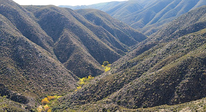
Looking down into Oriflamme Canyon from the MVTT
An oriflamme or “golden flame” appeared on the red battle standard of the King of France during the Middle Ages. It is unlikely that Oriflamme Canyon was named for this, although a red banner could have marked a mining claim in the canyon. More likely, the canyon was named for the side-wheel steamship named Oriflamme that brought the first miners to the area in 1870 during the Julian gold rush. The steamship regularly stopped at San Diego Harbor as part of its route between San Francisco and the Atlantic Ocean. Oriflamme was the name first given to a mine worked in the area, and the canyon and mountain soon followed.
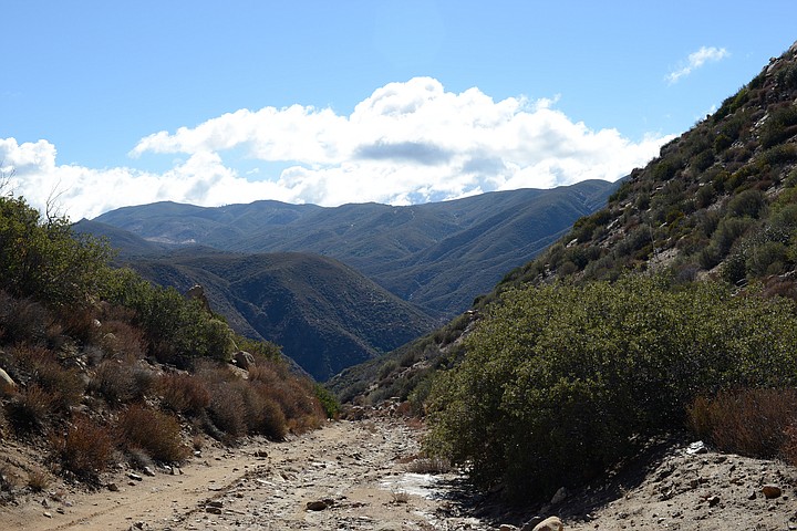
The Mason Valley Truck Trail descends into Oriflamme Canyon
The name, however, has little to do with the historic and scenic attributes of the canyon, which are considerable. It was the main route between Kumeyaay villages in the desert and summer encampments in the Laguna Mountains. It was the route Col. Pedro Fages took in 1772 while searching for army deserters, making him the first European to set foot in the Anza-Borrego desert that lived to write about it. In the 19th Century, cattle ranchers who had settled near Vallecito built a rough road through Oriflamme Canyon to move their cattle to summer pasture in the Laguna Mountains. Much of that road still exists as the Mason Valley Truck Trail and is part of the route of this hike. In the 1850s, Oriflamme Canyon was a leg on a transcontinental mail route called “The San Antonio and San Diego Mail Line.” It came to be known as the “Jackass Mail” because it used mules to pull wagons up the steep road through the canyon.
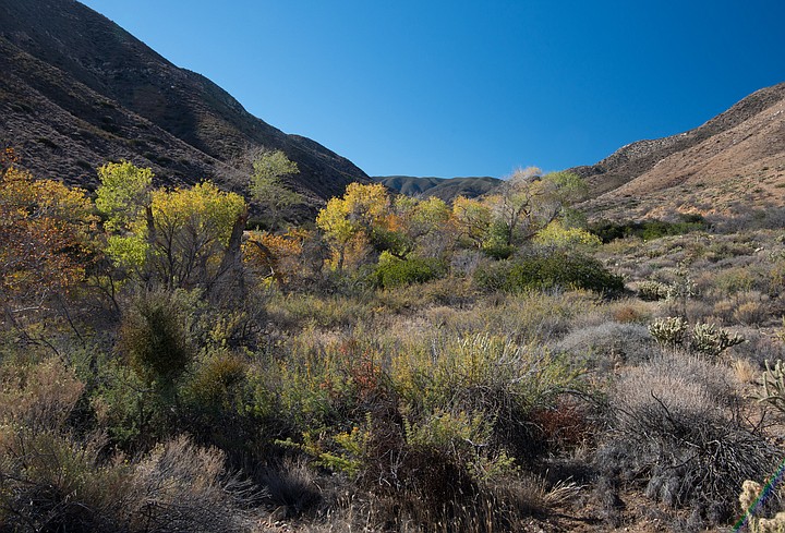
Oriflamme trees along the canyon stream course
If time and energy are available before beginning the hike, explore Oriflamme Canyon’s stream course, a riparian habitat containing a lush growth of California sycamores, western willows, western cottonwoods, and mulefat. Indian grinding areas are found among the boulders as well as evidence of an old road camp.
In wet years a bubbling stream flows over granite boulders and there is a small waterfall about a mile up the canyon. However, in the past few years little or no water has reached the surface in this part of the canyon and the falls have been dry.
Begin the actual hike from the parked vehicle, following the MVTT west-southwest on the road as it rises rather steeply up the north side of the canyon, gaining about 1500 feet of elevation in 1.6 miles. The reward is the view down to the Oriflamme stream course, a lively green most of the year but developing yellow and orange colors in the fall. The vegetation initially is typical high desert, including junipers, cholla, prickly pear cactus, Mojave yucca, and agave. Once above the canyon, the vegetation changes into montane chaparral dominated by scrub oaks, mountain mahogany, chamise, Parish goldenbush, California buckwheat, Eastwood manzanita, and many others. When seen at a distance, the higher hills appear to be covered with an olive-green velvet blanket.
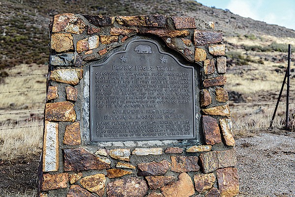
Oriflamme-Fages Monument
Continue up the road as it enters a side canyon, leaving Oriflamme Canyon in about half a mile. Exiting the canyon, there is a broad saddle that marks the divide between Oriflamme and Chariot canyons. Now the road is nearly flat and the hiking easy. Look for a sign for the California Riding and Hiking Trail (CR&HT) off to the left. Take it. The next 0.7 mile also is nearly flat, but just ahead is another ascent, this time rising up 500 feet in half a mile to the divide between Oriflamme and Cuyamaca drainages. After 3.85 miles from the start of the hike, the dirt road is left behind as the Pacific Crest Trail is briefly joined, also signed as the CR&HT. Continue following the CR&HT west-southwest through a series of deer-grass meadows to the Fages Monument on the Sunrise Highway (SR-1), 4.56 miles from the start of the hike. Reverse direction to return to your vehicle, unless arrangements were made to pick you up at the monument.
If attempting this hike from the Sunrise Highway, just follow the reverse of the above directions. The Sunrise Highway option is recommended for those without a 4wd vehicle. Drive a short distance east from Julian to the junction of state routes 78 and 79. Go right (south) on SR-79 and continue 6 miles to the Sunrise Highway junction on the left. Continue 1.6 miles on the Sunrise Highway to the Fages Monument and a roadside parking area on the left.
Oriflamme Canyon and the Mason Valley Truck Trail
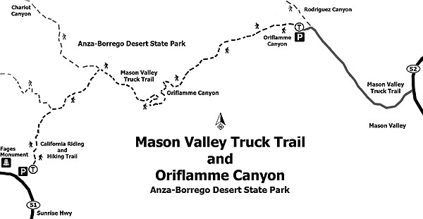
- Distance from downtown San Diego: About 85 miles (allow 2 hours) using a 4wd vehicle. (For an alternate route with no 4wd, see the bottom of this article.) Drive to Julian and head east 12 miles on SR-78 to Scissors Crossing. Go right (south) on SR-2 and continue for another 10 miles past Box Canyon to a dirt road on the right that is signed “Oriflamme Canyon,” the start of the Mason Valley Truck Trail (MVTT). Drive 2.8 miles on the MVTT, watching out for soft sand, boulders and, after storms, mud or even running water. Part of the road is in the usually dry Vallecito Creek bed. At 2.0 miles, a road heading for Rodriguez Canyon branches off to the right. Stay on the left branch and continue for another 0.8 mile to where a road descends a short distance to trees lining Oriflamme Creek. Park here to begin the hike.
- Hiking length: Just over 9 miles out and back.
- Difficulty: Moderately strenuous with about 2500 feet of elevation gain/loss. No facilities. Carry water. Parts of this route are closed to mountain bikers and motorized vehicles. The route described here assumes you will be on foot.
Here's something you might be interested in.
A historic route used by Indians, Spaniards, and the Jackass Mail
A historic route used by Indians, Spaniards, and the Jackass Mail
Looking down into Oriflamme Canyon from the MVTT
An oriflamme or “golden flame” appeared on the red battle standard of the King of France during the Middle Ages. It is unlikely that Oriflamme Canyon was named for this, although a red banner could have marked a mining claim in the canyon. More likely, the canyon was named for the side-wheel steamship named Oriflamme that brought the first miners to the area in 1870 during the Julian gold rush. The steamship regularly stopped at San Diego Harbor as part of its route between San Francisco and the Atlantic Ocean. Oriflamme was the name first given to a mine worked in the area, and the canyon and mountain soon followed.
The Mason Valley Truck Trail descends into Oriflamme Canyon
The name, however, has little to do with the historic and scenic attributes of the canyon, which are considerable. It was the main route between Kumeyaay villages in the desert and summer encampments in the Laguna Mountains. It was the route Col. Pedro Fages took in 1772 while searching for army deserters, making him the first European to set foot in the Anza-Borrego desert that lived to write about it. In the 19th Century, cattle ranchers who had settled near Vallecito built a rough road through Oriflamme Canyon to move their cattle to summer pasture in the Laguna Mountains. Much of that road still exists as the Mason Valley Truck Trail and is part of the route of this hike. In the 1850s, Oriflamme Canyon was a leg on a transcontinental mail route called “The San Antonio and San Diego Mail Line.” It came to be known as the “Jackass Mail” because it used mules to pull wagons up the steep road through the canyon.
Oriflamme trees along the canyon stream course
If time and energy are available before beginning the hike, explore Oriflamme Canyon’s stream course, a riparian habitat containing a lush growth of California sycamores, western willows, western cottonwoods, and mulefat. Indian grinding areas are found among the boulders as well as evidence of an old road camp.
In wet years a bubbling stream flows over granite boulders and there is a small waterfall about a mile up the canyon. However, in the past few years little or no water has reached the surface in this part of the canyon and the falls have been dry.
Begin the actual hike from the parked vehicle, following the MVTT west-southwest on the road as it rises rather steeply up the north side of the canyon, gaining about 1500 feet of elevation in 1.6 miles. The reward is the view down to the Oriflamme stream course, a lively green most of the year but developing yellow and orange colors in the fall. The vegetation initially is typical high desert, including junipers, cholla, prickly pear cactus, Mojave yucca, and agave. Once above the canyon, the vegetation changes into montane chaparral dominated by scrub oaks, mountain mahogany, chamise, Parish goldenbush, California buckwheat, Eastwood manzanita, and many others. When seen at a distance, the higher hills appear to be covered with an olive-green velvet blanket.
Oriflamme-Fages Monument
Continue up the road as it enters a side canyon, leaving Oriflamme Canyon in about half a mile. Exiting the canyon, there is a broad saddle that marks the divide between Oriflamme and Chariot canyons. Now the road is nearly flat and the hiking easy. Look for a sign for the California Riding and Hiking Trail (CR&HT) off to the left. Take it. The next 0.7 mile also is nearly flat, but just ahead is another ascent, this time rising up 500 feet in half a mile to the divide between Oriflamme and Cuyamaca drainages. After 3.85 miles from the start of the hike, the dirt road is left behind as the Pacific Crest Trail is briefly joined, also signed as the CR&HT. Continue following the CR&HT west-southwest through a series of deer-grass meadows to the Fages Monument on the Sunrise Highway (SR-1), 4.56 miles from the start of the hike. Reverse direction to return to your vehicle, unless arrangements were made to pick you up at the monument.
If attempting this hike from the Sunrise Highway, just follow the reverse of the above directions. The Sunrise Highway option is recommended for those without a 4wd vehicle. Drive a short distance east from Julian to the junction of state routes 78 and 79. Go right (south) on SR-79 and continue 6 miles to the Sunrise Highway junction on the left. Continue 1.6 miles on the Sunrise Highway to the Fages Monument and a roadside parking area on the left.
Oriflamme Canyon and the Mason Valley Truck Trail
- Distance from downtown San Diego: About 85 miles (allow 2 hours) using a 4wd vehicle. (For an alternate route with no 4wd, see the bottom of this article.) Drive to Julian and head east 12 miles on SR-78 to Scissors Crossing. Go right (south) on SR-2 and continue for another 10 miles past Box Canyon to a dirt road on the right that is signed “Oriflamme Canyon,” the start of the Mason Valley Truck Trail (MVTT). Drive 2.8 miles on the MVTT, watching out for soft sand, boulders and, after storms, mud or even running water. Part of the road is in the usually dry Vallecito Creek bed. At 2.0 miles, a road heading for Rodriguez Canyon branches off to the right. Stay on the left branch and continue for another 0.8 mile to where a road descends a short distance to trees lining Oriflamme Creek. Park here to begin the hike.
- Hiking length: Just over 9 miles out and back.
- Difficulty: Moderately strenuous with about 2500 feet of elevation gain/loss. No facilities. Carry water. Parts of this route are closed to mountain bikers and motorized vehicles. The route described here assumes you will be on foot.