Here's something you might be interested in.
Ask a Hipster — Advice you didn't know you needed
Big Screen — Movie commentary
Blurt — Music's inside track
Booze News — San Diego spirits
Classical Music — Immortal beauty
Classifieds — Free and easy
Close to Home — What it’s like on the street where you live
Cover Stories — Front-page features
Drinks All Around — Bartenders' drink recipes
Excerpts — Literary and spiritual excerpts
Feast! — Food & drink reviews
Feature Stories — Local news & stories
Fishing Report — What’s getting hooked from ship and shore
From the Archives — Spotlight on the past
Golden Dreams — Talk of the town
The Gonzo Report — Making the musical scene, or at least reporting from it
Letters — Our inbox
Movies@Home — Local movie buffs share favorites
Movie Reviews — Our critics' picks and pans
Musician Interviews — Up close with local artists
Neighborhood News from Stringers — Hyperlocal news
News Ticker — News & politics
Obermeyer — San Diego politics illustrated
Outdoors — Weekly changes in flora and fauna
Overheard in San Diego — Eavesdropping illustrated
Poetry — The old and the new
Reader Travel — Travel section built by travelers
Reading — The hunt for intellectuals
Roam-O-Rama — SoCal's best hiking/biking trails
San Diego Beer — Inside San Diego suds
SD on the QT — Almost factual news
Sheep and Goats — Places of worship
Special Issues — The best of
Street Style — San Diego streets have style
Surf Diego — Real stories from those braving the waves
Theater — On stage in San Diego this week
Tin Fork — Silver spoon alternative
Under the Radar — Matt Potter's undercover work
Unforgettable — Long-ago San Diego
Unreal Estate — San Diego's priciest pads
Your Week — Daily event picks
Rough country's rewards
A hiking tour of the Tijuana River Valley
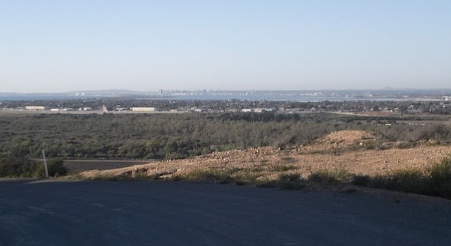
A view of el norte from Tijuana River Valley
There should be a sign, I say to myself every time I park at the end of Monument Road to go hike the Tijuana River Valley. Like the “welcome to our habitat” signs for rattlesnakes and the mountain lions and on the beach where endangered birds breed. But this sign should say: “You are entering a border enforcement area.”
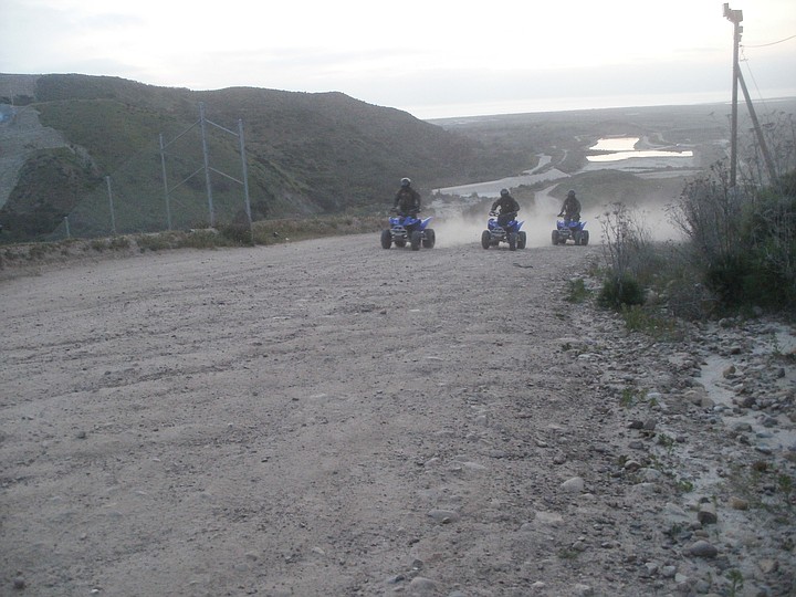
Border Patrol agents on quads
Could be 100 years ago...
You will encounter Border Patrol agents. But no one will put that sign up. So, an awful lot of people come hiking here once and leave a little perturbed or insulted that a cop stopped and asked them where they were coming from or where they were going to. Which is sad, because their presence here is why this Alice in Wonderland mix of endangered habitat, wildlife, trash, astonishing views, and rare plants and animals is a good place to go hiking. It’s safe and really interesting.
The county will be finishing up the first official trails to the two high mesas in the Tijuana River Valley Regional Park, Spooner’s, and the eastern one that goes by names including East Smugglers, Valley View, and Monument Mesa, per the parks. They’re urban trails in rough country that, when you get up high and look north, will knock you out with views of the valley and the cities beyond. But you are also less than a quarter of a mile from Tijuana, from a fence that tries to define the difference between nations.
I first started hiking here in 2010 for a school project. Then, as now, I had the place mostly to myself. I can’t remember the first time I walked up to the top of Spooner’s Mesa, but I knew then I was hooked. Both the north and south roads up the hill are long and steep and give you a sense of the altitude you’ve gained.
The official trail, the north road, climbs with astonishing views north to downtown San Diego and Point Loma, to the east of Otay Mountain, and the mountains in Poway. Houses, streets, civilization to the south stop at the edge of the valley. By the first switchback in the road, where there’s a new bench and corral, you can see the wide valley. It was U.S. Navy land, then ranch land. Several times a decade, flooded land — so reliably so that San Diego Fire and Rescue’s Swift Water Team comes to the valley and stands ready after a day or two of real rain.
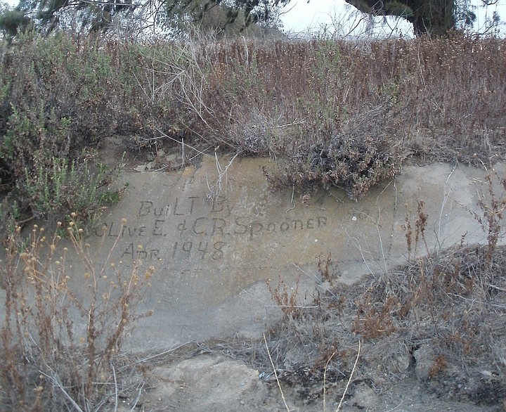
Spooner's cistern
Discarded rag and wire that likely covered a shoe

A monument of shoes
The estuary at the west end was wrenched from the teeth of developers — the efforts of a group led by Dr. Mike McCoy, pulled off through determination and the power of friends. Spooner’s Mesa was a ranch and the remnants are still there — a wall and a half of a homestead, random fencing on the hillsides, and neat rows of trees built as windbreaks next to the dirt roads.
At the center of the oval, C.R and Olive Spooner poured a concrete cistern to catch rainwater for the ranch they had — you can tell because on the west wall by the southwest corner, they signed their names and the date.
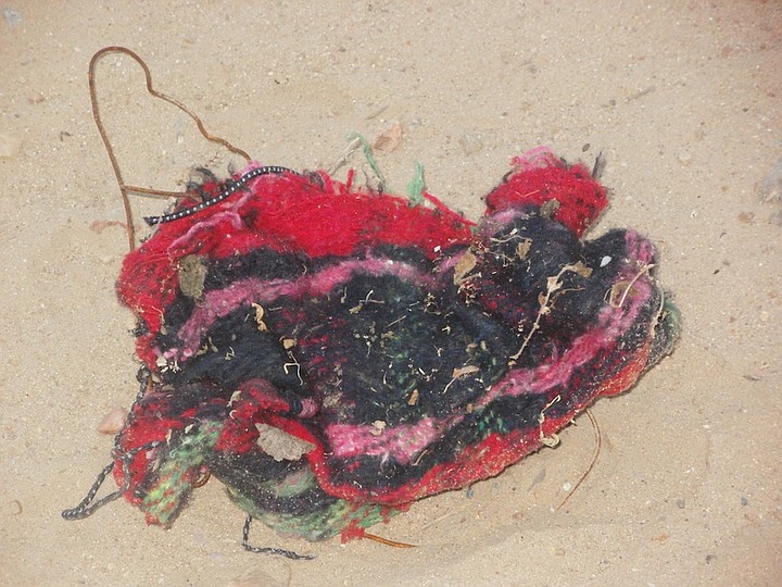
If you’ve come this far, you’ve seen your first pair of booties. Those bits of rough plaid blanket on the ground the size of a wadded guest towel and wrapped with baling wire came off the feet of someone traveling north. They leave footprints like a cotton ball instead of a shoe sole, and pairs usually turn up separated a short distance.
You can make a Border Patrol agent laugh by telling him the booties are art: a statement about the disguises we wear and shed to get to where we want to or must go, a cocoon left behind; an homage to concealment and exposure. To the agent, they’re a piece of crime detritus and to the parks rangers, trash. To me, they make a hike interesting, like the backpacks and clothes you’ll come across emptied and abandoned. A toothbrush, a tin of deodorant, and so many water bottles with water still in them.
On a really interesting day, you might get to see people wearing those booties and running. I have, more than a dozen times. Like lightning and thunder, I count the seconds between when I first see the person or people in booties and then hear the vehicles. You already saw the Border Patrol Yukon or Jeep sitting still near a bluff’s edge, but you probably didn’t know there were so many other agents and vehicles out there until they all rush in.
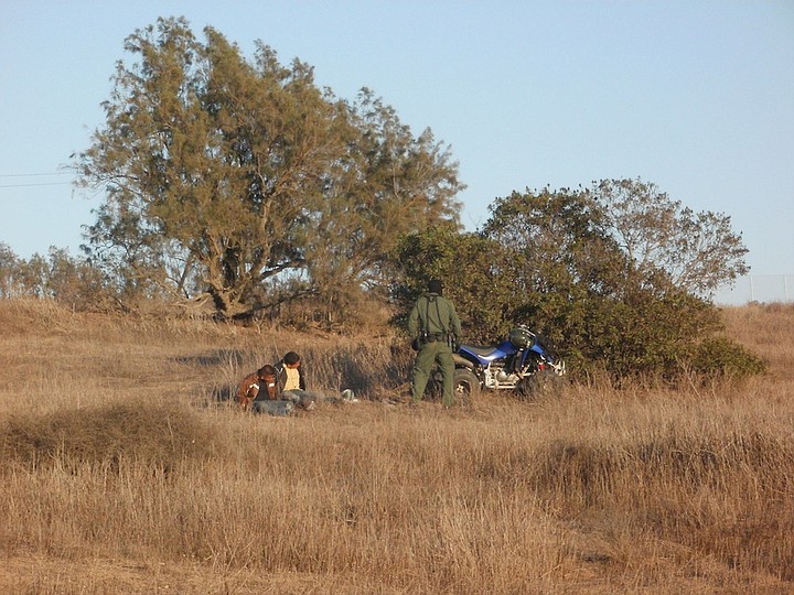
Border Patrol makes an arrest
Best suggestion: step out of the way and to where they can see you. And then wave. They don’t see a lot of that. Second best suggestion: Do not run. You don’t have to take sides here and it’s better if you don’t. There are people who want to get into the country and people whose job is to catch them. There are people who toil to protect the habitat and people who maintain the valley’s ballfields and vegetable gardens.
Some other things you’ll see: cheap bicycles thrown in the brush partly dismantled so they can’t be reused by a second round of runners. Bikes are a common method for crossing the border as well. I always look at the bicyclists closely — as does the Border Patrol. Some are wearing jerseys and modern helmets and have their feet clipped into the pedals. And some are wearing baggy shorts over hairy legs and a look of terror and determination.
Ladders
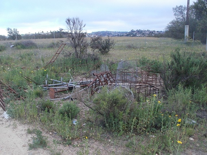
There are stacks of ladders made of rebar — fewer right now since the park picked them up, but new ones appear every day. The ladders, used to climb over the high steel fence are a testament to human ingenuity and the determination it takes to climb a wobbly, thin ladder and jump. No one minds if you pick one up and take it home as a souvenir. I know this because I have several.
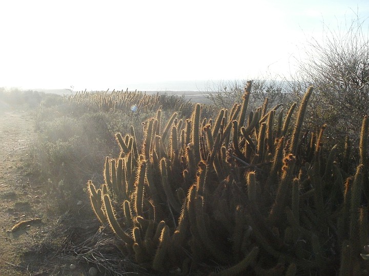
I’ve been hiking here by myself for a few years and the worst thing that’s happened is getting nailed by cactus. There are snakes and coyote, and I’ve seen bobcats and border dogs, too. If you hear a bird call that sounds like a cat, that’s a California gnatcatcher. There are hawks all over the place near the bluffs.
If you’re headed to the beach — from the same lot at the end of the road, take a side trip up to Bunker Hill, the low high hill directly south of the parking lot that wears the old fence like my grandma’s cocktail hat. You can walk up to the lower part of the mesa on what will be named “Bunkers Trail” on the next map.
You trudge up a decomposed granite road to a curve that will take your breath away when you look west. It’s been planted with natives and transformed into “the model marsh” — where historic photos show a military village and an airstrip. The Army used the land to train soldiers to shoot and to drive tanks here for a while during World War II. It’s almost lush now.
Head a little south, but not too much. That wretched corrugated metal is the border, and on many days, there are people just past it. Even the Army Corps of Engineers couldn’t push the high steel fence up this hill. Between the fence and you, state parks has been planting stands of cholla cactus in hopes of attracting cactus wrens. California gnatcatchers are already here on the sides of the steep hill up to the high mesa.
There is no official trail up to the high hill. I was up there a few times while I was writing the application for the World War II bunkers up there to be put on the National Historic Register — it’s the highest point before Otay Mountain — and it is gorgeous in three directions and fascinating when you look south.
Here's something you might be interested in.
Rough country's rewards
A hiking tour of the Tijuana River Valley
Rough country's rewards
A hiking tour of the Tijuana River Valley
A view of el norte from Tijuana River Valley
There should be a sign, I say to myself every time I park at the end of Monument Road to go hike the Tijuana River Valley. Like the “welcome to our habitat” signs for rattlesnakes and the mountain lions and on the beach where endangered birds breed. But this sign should say: “You are entering a border enforcement area.”
Border Patrol agents on quads
Could be 100 years ago...
You will encounter Border Patrol agents. But no one will put that sign up. So, an awful lot of people come hiking here once and leave a little perturbed or insulted that a cop stopped and asked them where they were coming from or where they were going to. Which is sad, because their presence here is why this Alice in Wonderland mix of endangered habitat, wildlife, trash, astonishing views, and rare plants and animals is a good place to go hiking. It’s safe and really interesting.
The county will be finishing up the first official trails to the two high mesas in the Tijuana River Valley Regional Park, Spooner’s, and the eastern one that goes by names including East Smugglers, Valley View, and Monument Mesa, per the parks. They’re urban trails in rough country that, when you get up high and look north, will knock you out with views of the valley and the cities beyond. But you are also less than a quarter of a mile from Tijuana, from a fence that tries to define the difference between nations.
I first started hiking here in 2010 for a school project. Then, as now, I had the place mostly to myself. I can’t remember the first time I walked up to the top of Spooner’s Mesa, but I knew then I was hooked. Both the north and south roads up the hill are long and steep and give you a sense of the altitude you’ve gained.
The official trail, the north road, climbs with astonishing views north to downtown San Diego and Point Loma, to the east of Otay Mountain, and the mountains in Poway. Houses, streets, civilization to the south stop at the edge of the valley. By the first switchback in the road, where there’s a new bench and corral, you can see the wide valley. It was U.S. Navy land, then ranch land. Several times a decade, flooded land — so reliably so that San Diego Fire and Rescue’s Swift Water Team comes to the valley and stands ready after a day or two of real rain.
Spooner's cistern
Discarded rag and wire that likely covered a shoe
A monument of shoes
The estuary at the west end was wrenched from the teeth of developers — the efforts of a group led by Dr. Mike McCoy, pulled off through determination and the power of friends. Spooner’s Mesa was a ranch and the remnants are still there — a wall and a half of a homestead, random fencing on the hillsides, and neat rows of trees built as windbreaks next to the dirt roads.
At the center of the oval, C.R and Olive Spooner poured a concrete cistern to catch rainwater for the ranch they had — you can tell because on the west wall by the southwest corner, they signed their names and the date.
If you’ve come this far, you’ve seen your first pair of booties. Those bits of rough plaid blanket on the ground the size of a wadded guest towel and wrapped with baling wire came off the feet of someone traveling north. They leave footprints like a cotton ball instead of a shoe sole, and pairs usually turn up separated a short distance.
You can make a Border Patrol agent laugh by telling him the booties are art: a statement about the disguises we wear and shed to get to where we want to or must go, a cocoon left behind; an homage to concealment and exposure. To the agent, they’re a piece of crime detritus and to the parks rangers, trash. To me, they make a hike interesting, like the backpacks and clothes you’ll come across emptied and abandoned. A toothbrush, a tin of deodorant, and so many water bottles with water still in them.
On a really interesting day, you might get to see people wearing those booties and running. I have, more than a dozen times. Like lightning and thunder, I count the seconds between when I first see the person or people in booties and then hear the vehicles. You already saw the Border Patrol Yukon or Jeep sitting still near a bluff’s edge, but you probably didn’t know there were so many other agents and vehicles out there until they all rush in.
Border Patrol makes an arrest
Best suggestion: step out of the way and to where they can see you. And then wave. They don’t see a lot of that. Second best suggestion: Do not run. You don’t have to take sides here and it’s better if you don’t. There are people who want to get into the country and people whose job is to catch them. There are people who toil to protect the habitat and people who maintain the valley’s ballfields and vegetable gardens.
Some other things you’ll see: cheap bicycles thrown in the brush partly dismantled so they can’t be reused by a second round of runners. Bikes are a common method for crossing the border as well. I always look at the bicyclists closely — as does the Border Patrol. Some are wearing jerseys and modern helmets and have their feet clipped into the pedals. And some are wearing baggy shorts over hairy legs and a look of terror and determination.
Ladders
There are stacks of ladders made of rebar — fewer right now since the park picked them up, but new ones appear every day. The ladders, used to climb over the high steel fence are a testament to human ingenuity and the determination it takes to climb a wobbly, thin ladder and jump. No one minds if you pick one up and take it home as a souvenir. I know this because I have several.
I’ve been hiking here by myself for a few years and the worst thing that’s happened is getting nailed by cactus. There are snakes and coyote, and I’ve seen bobcats and border dogs, too. If you hear a bird call that sounds like a cat, that’s a California gnatcatcher. There are hawks all over the place near the bluffs.
If you’re headed to the beach — from the same lot at the end of the road, take a side trip up to Bunker Hill, the low high hill directly south of the parking lot that wears the old fence like my grandma’s cocktail hat. You can walk up to the lower part of the mesa on what will be named “Bunkers Trail” on the next map.
You trudge up a decomposed granite road to a curve that will take your breath away when you look west. It’s been planted with natives and transformed into “the model marsh” — where historic photos show a military village and an airstrip. The Army used the land to train soldiers to shoot and to drive tanks here for a while during World War II. It’s almost lush now.
Head a little south, but not too much. That wretched corrugated metal is the border, and on many days, there are people just past it. Even the Army Corps of Engineers couldn’t push the high steel fence up this hill. Between the fence and you, state parks has been planting stands of cholla cactus in hopes of attracting cactus wrens. California gnatcatchers are already here on the sides of the steep hill up to the high mesa.
There is no official trail up to the high hill. I was up there a few times while I was writing the application for the World War II bunkers up there to be put on the National Historic Register — it’s the highest point before Otay Mountain — and it is gorgeous in three directions and fascinating when you look south.
Comments