Here's something you might be interested in.
Ask a Hipster — Advice you didn't know you needed
Big Screen — Movie commentary
Blurt — Music's inside track
Booze News — San Diego spirits
Classical Music — Immortal beauty
Classifieds — Free and easy
Close to Home — What it’s like on the street where you live
Cover Stories — Front-page features
Drinks All Around — Bartenders' drink recipes
Excerpts — Literary and spiritual excerpts
Feast! — Food & drink reviews
Feature Stories — Local news & stories
Fishing Report — What’s getting hooked from ship and shore
From the Archives — Spotlight on the past
Golden Dreams — Talk of the town
The Gonzo Report — Making the musical scene, or at least reporting from it
Letters — Our inbox
Movies@Home — Local movie buffs share favorites
Movie Reviews — Our critics' picks and pans
Musician Interviews — Up close with local artists
Neighborhood News from Stringers — Hyperlocal news
News Ticker — News & politics
Obermeyer — San Diego politics illustrated
Outdoors — Weekly changes in flora and fauna
Overheard in San Diego — Eavesdropping illustrated
Poetry — The old and the new
Reader Travel — Travel section built by travelers
Reading — The hunt for intellectuals
Roam-O-Rama — SoCal's best hiking/biking trails
San Diego Beer — Inside San Diego suds
SD on the QT — Almost factual news
Sheep and Goats — Places of worship
Special Issues — The best of
Street Style — San Diego streets have style
Surf Diego — Real stories from those braving the waves
Theater — On stage in San Diego this week
Tin Fork — Silver spoon alternative
Under the Radar — Matt Potter's undercover work
Unforgettable — Long-ago San Diego
Unreal Estate — San Diego's priciest pads
Your Week — Daily event picks
Escape to Palomar Mountain
Look out! It's beautiful!
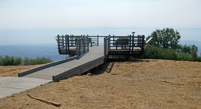
The Boucher Outlook viewing deck has interpretive panels.
There is a lot to enjoy on this short scenic hike, including local and natural history. From the Silvercrest parking area, walk back out to the parking entrance and turn left. Alternatively, walk through the Silvercrest Picnic Area, where there is a trail sign leading to the park road. Go downhill along the main paved road while keeping to the right side of the road to avoid any traffic along the blind curve. Along the road, begin enjoying the diversity of plant life, from coffeeberry and chokecherry to scarlet bugler. Proceed past the ranger’s house to the junction of Nate Harrison Road and the Campground Road. At the junction there is a stone plaque on the left that commemorates those who served in the Civilian Conservation Corps (CCC) on Palomar Mountain and across the United States. The CCC was responsible for building structures and trails in the park.
On the left, there is a narrow trailhead ahead that is located between a one-way paved loop road. This trail maintains a gentle ascent through partially shaded and open mixed conifer forest. The hike is ideal in the fall when the Kellogg black oak trees are changing color. Black-tailed mule deer are frequently seen along this portion of the trail. Palomar Mountain is known for its wide diversity of plants and wildlife. There is plenty to investigate along the way while hiking among tall trees, scrub, chaparral, and meadow communities.
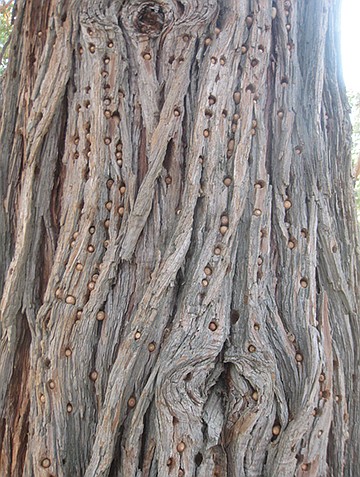
Acorn woodpeckers custom-fit each acorn tightly in a storage hole.
The trail begins on a moderate slope with partially open areas. Along the trail there is evidence of past fires, including hollow logs and burnt tree sculptures. Palomar has sustained several fires over the years, including a severe firestorm in the 1980s. Continuing uphill, the trail will eventually become more level and shady, and there will be views through the trees off of both sides of the trail. To the right, Lower French Valley is visible below in the distance, and to the left are views down the mountain. The trail will drop downhill briefly and join the paved loop road. Stay on the dirt trail to the right for now in order to enjoy the left-side views more fully upon your return trip via the paved loop road.
Look for several massive incense cedar trees covered with acorn caches that will be passed along the route. The trees are used over time by many generations of acorn woodpeckers. The birds custom-fit acorns into the holes they make for storage. They are sure to make the acorns fit tightly, so that the squirrels and chipmunks have difficulty stealing their food. You may hear them tapping on wood, making raucous calls, or see them in flight. They can be identified by their white wing patches and undulating flight pattern.
At the top of the trail, there is a historical fire lookout tower, viewing deck, and picnic area. The current fire tower is the third lookout structure built on this location. This tower was transported here in 1948 and was in use until 1983. It was reopened in 2012 and is often manned with friendly volunteers who will invite you to come up the tower for a visit. The top of the tower provides a 360-degree view. The volunteers will share information about how to determine the direction and distance of a smoke plume or fire.
The viewing deck is a separate structure at ground level, looks out over the edge of the point, and provides a panoramic view to the north, west, and southeast. On clear days, it is possible to view as far as the Coronado Islands and Baja California with the naked eye. However, there is also a scope available for your use. The deck includes informative panels on the history of the area. A parking lot at the top provides easy access for visitors, making summer weekends and holidays a busy time to visit.
Once the surrounding area is explored, return to the parking area by following the road to the left from the fire-tower picnic area. This road circles around the hill while hugging the edge of the mountain, providing more outstanding views. The road is not used frequently, but be aware of the possibility of downhill traffic. Look for paloma or band-tailed pigeons, as they tend to roost in the trees of this area. The paloma are a native bird, much larger than a city pigeon. Palomar Mountain is named after this bird, since palomar is a Spanish word meaning “pigeon roost.”
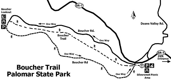
On the descent back to the starting point, the route will merge with the main park road. A right turn will lead back uphill to the Silvercrest parking lot. While at Silvercrest, take the time to walk the path from the parking lot along the left side of the picnic area. There, you will find morteros used by the Luiseño Indians and a 400-year-old incense cedar.
- Distance from downtown San Diego: About 77 miles. Allow up to 2 hours driving time. Take I-15 N and exit on SR-76 E. Drive 20.7 miles on SR-76 E and turn left on Palomar Mountain Road, also called SR-6 and South Grade Road. Drive 6.8 miles to the top of the South Grade and turn left on SR-6. Take an immediate left again on SR-7 (just before the store and restaurant) to Palomar Mountain State Park. Pay day-use fee. Take the first left past the kiosk and park at the Silvercrest Picnic Area. There are no gas stations on Palomar Mountain. Restrooms are available at Silvercrest and Boucher Point.
- Hiking length: 2 miles round trip.
- Difficulty: Easy/Moderate. Elevation change: 250 feet. The trailhead begins at 5200 feet and gradually climbs to 5450 feet at Boucher Point. Water available at the Silvercrest picnic area.
Here's something you might be interested in.
Escape to Palomar Mountain
Look out! It's beautiful!
Escape to Palomar Mountain
Look out! It's beautiful!
The Boucher Outlook viewing deck has interpretive panels.
There is a lot to enjoy on this short scenic hike, including local and natural history. From the Silvercrest parking area, walk back out to the parking entrance and turn left. Alternatively, walk through the Silvercrest Picnic Area, where there is a trail sign leading to the park road. Go downhill along the main paved road while keeping to the right side of the road to avoid any traffic along the blind curve. Along the road, begin enjoying the diversity of plant life, from coffeeberry and chokecherry to scarlet bugler. Proceed past the ranger’s house to the junction of Nate Harrison Road and the Campground Road. At the junction there is a stone plaque on the left that commemorates those who served in the Civilian Conservation Corps (CCC) on Palomar Mountain and across the United States. The CCC was responsible for building structures and trails in the park.
On the left, there is a narrow trailhead ahead that is located between a one-way paved loop road. This trail maintains a gentle ascent through partially shaded and open mixed conifer forest. The hike is ideal in the fall when the Kellogg black oak trees are changing color. Black-tailed mule deer are frequently seen along this portion of the trail. Palomar Mountain is known for its wide diversity of plants and wildlife. There is plenty to investigate along the way while hiking among tall trees, scrub, chaparral, and meadow communities.
Acorn woodpeckers custom-fit each acorn tightly in a storage hole.
The trail begins on a moderate slope with partially open areas. Along the trail there is evidence of past fires, including hollow logs and burnt tree sculptures. Palomar has sustained several fires over the years, including a severe firestorm in the 1980s. Continuing uphill, the trail will eventually become more level and shady, and there will be views through the trees off of both sides of the trail. To the right, Lower French Valley is visible below in the distance, and to the left are views down the mountain. The trail will drop downhill briefly and join the paved loop road. Stay on the dirt trail to the right for now in order to enjoy the left-side views more fully upon your return trip via the paved loop road.
Look for several massive incense cedar trees covered with acorn caches that will be passed along the route. The trees are used over time by many generations of acorn woodpeckers. The birds custom-fit acorns into the holes they make for storage. They are sure to make the acorns fit tightly, so that the squirrels and chipmunks have difficulty stealing their food. You may hear them tapping on wood, making raucous calls, or see them in flight. They can be identified by their white wing patches and undulating flight pattern.
At the top of the trail, there is a historical fire lookout tower, viewing deck, and picnic area. The current fire tower is the third lookout structure built on this location. This tower was transported here in 1948 and was in use until 1983. It was reopened in 2012 and is often manned with friendly volunteers who will invite you to come up the tower for a visit. The top of the tower provides a 360-degree view. The volunteers will share information about how to determine the direction and distance of a smoke plume or fire.
The viewing deck is a separate structure at ground level, looks out over the edge of the point, and provides a panoramic view to the north, west, and southeast. On clear days, it is possible to view as far as the Coronado Islands and Baja California with the naked eye. However, there is also a scope available for your use. The deck includes informative panels on the history of the area. A parking lot at the top provides easy access for visitors, making summer weekends and holidays a busy time to visit.
Once the surrounding area is explored, return to the parking area by following the road to the left from the fire-tower picnic area. This road circles around the hill while hugging the edge of the mountain, providing more outstanding views. The road is not used frequently, but be aware of the possibility of downhill traffic. Look for paloma or band-tailed pigeons, as they tend to roost in the trees of this area. The paloma are a native bird, much larger than a city pigeon. Palomar Mountain is named after this bird, since palomar is a Spanish word meaning “pigeon roost.”
On the descent back to the starting point, the route will merge with the main park road. A right turn will lead back uphill to the Silvercrest parking lot. While at Silvercrest, take the time to walk the path from the parking lot along the left side of the picnic area. There, you will find morteros used by the Luiseño Indians and a 400-year-old incense cedar.
- Distance from downtown San Diego: About 77 miles. Allow up to 2 hours driving time. Take I-15 N and exit on SR-76 E. Drive 20.7 miles on SR-76 E and turn left on Palomar Mountain Road, also called SR-6 and South Grade Road. Drive 6.8 miles to the top of the South Grade and turn left on SR-6. Take an immediate left again on SR-7 (just before the store and restaurant) to Palomar Mountain State Park. Pay day-use fee. Take the first left past the kiosk and park at the Silvercrest Picnic Area. There are no gas stations on Palomar Mountain. Restrooms are available at Silvercrest and Boucher Point.
- Hiking length: 2 miles round trip.
- Difficulty: Easy/Moderate. Elevation change: 250 feet. The trailhead begins at 5200 feet and gradually climbs to 5450 feet at Boucher Point. Water available at the Silvercrest picnic area.