Here's something you might be interested in.
Ask a Hipster — Advice you didn't know you needed
Big Screen — Movie commentary
Blurt — Music's inside track
Booze News — San Diego spirits
Classical Music — Immortal beauty
Classifieds — Free and easy
Close to Home — What it’s like on the street where you live
Cover Stories — Front-page features
Drinks All Around — Bartenders' drink recipes
Excerpts — Literary and spiritual excerpts
Feast! — Food & drink reviews
Feature Stories — Local news & stories
Fishing Report — What’s getting hooked from ship and shore
From the Archives — Spotlight on the past
Golden Dreams — Talk of the town
The Gonzo Report — Making the musical scene, or at least reporting from it
Letters — Our inbox
Movies@Home — Local movie buffs share favorites
Movie Reviews — Our critics' picks and pans
Musician Interviews — Up close with local artists
Neighborhood News from Stringers — Hyperlocal news
News Ticker — News & politics
Obermeyer — San Diego politics illustrated
Outdoors — Weekly changes in flora and fauna
Overheard in San Diego — Eavesdropping illustrated
Poetry — The old and the new
Reader Travel — Travel section built by travelers
Reading — The hunt for intellectuals
Roam-O-Rama — SoCal's best hiking/biking trails
San Diego Beer — Inside San Diego suds
SD on the QT — Almost factual news
Sheep and Goats — Places of worship
Special Issues — The best of
Street Style — San Diego streets have style
Surf Diego — Real stories from those braving the waves
Theater — On stage in San Diego this week
Tin Fork — Silver spoon alternative
Under the Radar — Matt Potter's undercover work
Unforgettable — Long-ago San Diego
Unreal Estate — San Diego's priciest pads
Your Week — Daily event picks
On the Trail of San Diego History: The Box Canyon That Got Away, Part Two.
Field Notes:
Fifty, 100, even 200 years after a historical event, you can get the feel of a place just by being there. Stand at the ruins on Presidio Hill, for example. Erase all the trees, all the buildings below, all the cars on the freeways. Then see why the first Alta California expedition of 1769 chose this spot to build their fort. It’s the most defendable high ground in the area: you can see for miles in almost every direction, from Point Loma to Mt. Soledad, far down Mission Valley, and Mexico.
And you can also feel how the near-constant winds flipped the tiles off adobe buildings, smashed them on the courtyard or the walls, and drove the Commandants nuts.
In 1837, after a band of Kumeyaay warriors burned Rancho Jamul, they herded the livestock, and two captive women, into the mountains. San Diegans paid the region’s number one hired gun, Macedonio Gonzalez to gather a force and go after them. In those days, and for years later, his first name struck terror. “For him to shoot an Indian,” wrote August Janssens, “was as easy a matter, it seemed, as taking a cup of chocolate.”
Macedonio followed the trail until he came to a box canyon, where 200 Kumeyaay warriors ambushed his party and did grave damage.
So. A box canyon in the back country, wide and tall, and obviously on a well-traveled trail.
Janssens, who was there, calls it “a narrow pass leading to the Colorado River,” and later a “defile” in the mountains.
Vicente Romero, also on the expedition: they went from “Jacum, Matacawat, Guatay, Cuyamaca Valley, and round to Valley de las Viejas” – then fought the battle at “Matadera” in the “Jacum Mountains.”
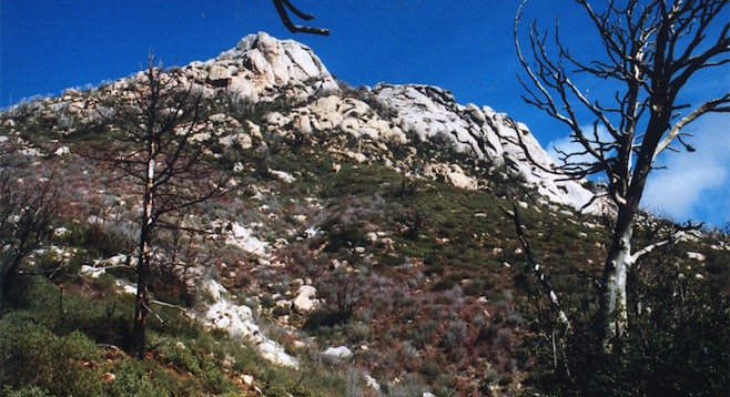
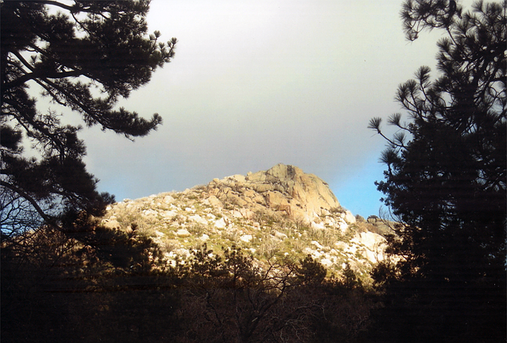
In an interview, Macedonio said he followed “age-old Indian trails,” eventually going through “Pine Valley to Guatay, and then up to Cuyamaca Valley” where the Kumeyaay had their “principal Rancheria” – village – “in a pile of rocks north of a sharp-pointed peak.”
Most conclude this was Stonewall, the 5000 foot peak due south of Lake Cuyamaca.
So did “Trusty,” my tramp-mate (aka Michael Clark), and I. When we went on this search, several years ago, we’d been batting 1.000: found everything we sought.
We went in the spring, early enough so the rattlers were still hibernating, but late enough, we figured, for the sun to warm our path.
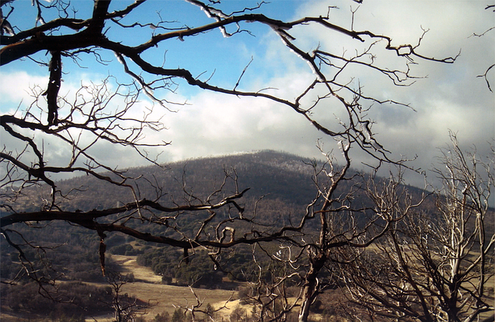
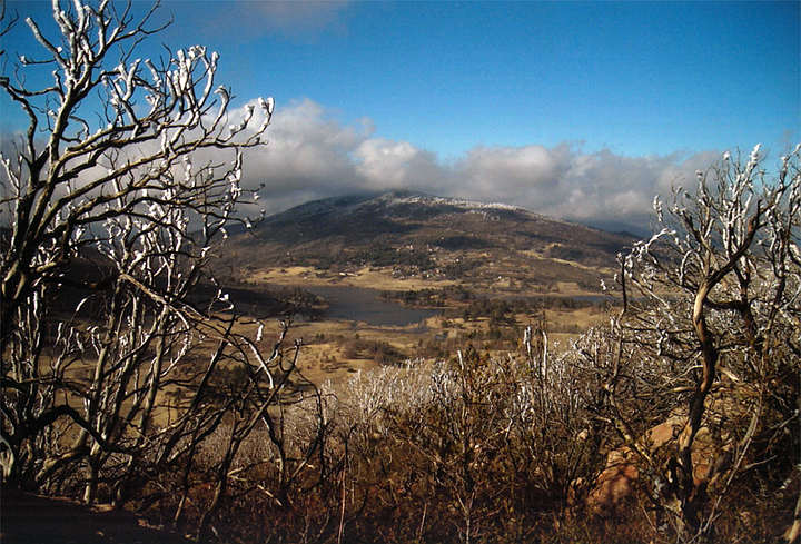
It snowed the night before. When we stood at the foot of Stonewall, the trees and hills were white. With permission from the local rangers – none of whom could suggest a likely spot - we searched canyons on both sides of Highway 79. But they were either too narrow, too small, or too far from a former thoroughfare.
We decided to climb Stonewall Peak. Get an overview. It was early afternoon, the ground was still cold, but the snow was melting in white gobs the size of basketballs. Whole hillsides looked like a giant’s cotton fields. Before a gob hit the ground, it made a swish, as it clattered through leafless branches, then a ka-boom, exploded in all directions.
As Trusty and I started up the long, switchback trail, we heard two women shouting above us. Couldn’t make out the high-pitched words. As they came around a turn and saw us, they screamed: “Go back! Mountain lion!”
I looked at Trusty, trying to sound all voice of reason, and said, “head back?”
“Naw,” he said, stomping ice off the soles of his hiking boots, “we go on.”
(Yeah, that Trusty: one time we were looking for an old mineshaft and the trail ended. "Stops here," I said,underlining the obvious. "No it don't," said the Trustmeister, surging forward with even grimmer determination).
We didn’t get far before a male voice shouted from below.
“You guys didn’t hear? Mountain lion.”
“We did,” said Trusty, on the move.
I pointed up and/or down, like a weathervane on the blink, suggesting either way would do. When the Ranger saw Trusty trudging up the grade, he said, “Let’s check it out.”
After he gave us safety instructions – such as keep your eyes up, since the big cat most likely will pounce from above, I quoted Hamlet. “For this relief much thanks.”
Trusty led the way. I was in the middle, looking and listening hard. At almost every step we took, or so it seemed, a clump of snow whistled through the branches and thumped-splashed on the ground – just like, I was convinced, a mountain lion.
“Lions and tigers and…” No, Dorothy, just one lion, probably so famished from a long, cold, lonely winter to consider a human triple-decker, hold the secret sauce.
So instead, my mantra became, “A lion, a lion, a lion – oh my!” – “oh my!” given heartfelt emphasis every time an ice-bomb hit nearby.
At the top of Stonewall, we saw gorgeous views but no site that fit the descriptions. It will always remain the box canyon that got away.
Fortunately for us, so will the mountain lion.
Here's something you might be interested in.
On the Trail of San Diego History: The Box Canyon That Got Away, Part Two.
On the Trail of San Diego History: The Box Canyon That Got Away, Part Two.
Field Notes:
Fifty, 100, even 200 years after a historical event, you can get the feel of a place just by being there. Stand at the ruins on Presidio Hill, for example. Erase all the trees, all the buildings below, all the cars on the freeways. Then see why the first Alta California expedition of 1769 chose this spot to build their fort. It’s the most defendable high ground in the area: you can see for miles in almost every direction, from Point Loma to Mt. Soledad, far down Mission Valley, and Mexico.
And you can also feel how the near-constant winds flipped the tiles off adobe buildings, smashed them on the courtyard or the walls, and drove the Commandants nuts.
In 1837, after a band of Kumeyaay warriors burned Rancho Jamul, they herded the livestock, and two captive women, into the mountains. San Diegans paid the region’s number one hired gun, Macedonio Gonzalez to gather a force and go after them. In those days, and for years later, his first name struck terror. “For him to shoot an Indian,” wrote August Janssens, “was as easy a matter, it seemed, as taking a cup of chocolate.”
Macedonio followed the trail until he came to a box canyon, where 200 Kumeyaay warriors ambushed his party and did grave damage.
So. A box canyon in the back country, wide and tall, and obviously on a well-traveled trail.
Janssens, who was there, calls it “a narrow pass leading to the Colorado River,” and later a “defile” in the mountains.
Vicente Romero, also on the expedition: they went from “Jacum, Matacawat, Guatay, Cuyamaca Valley, and round to Valley de las Viejas” – then fought the battle at “Matadera” in the “Jacum Mountains.”
In an interview, Macedonio said he followed “age-old Indian trails,” eventually going through “Pine Valley to Guatay, and then up to Cuyamaca Valley” where the Kumeyaay had their “principal Rancheria” – village – “in a pile of rocks north of a sharp-pointed peak.”
Most conclude this was Stonewall, the 5000 foot peak due south of Lake Cuyamaca.
So did “Trusty,” my tramp-mate (aka Michael Clark), and I. When we went on this search, several years ago, we’d been batting 1.000: found everything we sought.
We went in the spring, early enough so the rattlers were still hibernating, but late enough, we figured, for the sun to warm our path.
It snowed the night before. When we stood at the foot of Stonewall, the trees and hills were white. With permission from the local rangers – none of whom could suggest a likely spot - we searched canyons on both sides of Highway 79. But they were either too narrow, too small, or too far from a former thoroughfare.
We decided to climb Stonewall Peak. Get an overview. It was early afternoon, the ground was still cold, but the snow was melting in white gobs the size of basketballs. Whole hillsides looked like a giant’s cotton fields. Before a gob hit the ground, it made a swish, as it clattered through leafless branches, then a ka-boom, exploded in all directions.
As Trusty and I started up the long, switchback trail, we heard two women shouting above us. Couldn’t make out the high-pitched words. As they came around a turn and saw us, they screamed: “Go back! Mountain lion!”
I looked at Trusty, trying to sound all voice of reason, and said, “head back?”
“Naw,” he said, stomping ice off the soles of his hiking boots, “we go on.”
(Yeah, that Trusty: one time we were looking for an old mineshaft and the trail ended. "Stops here," I said,underlining the obvious. "No it don't," said the Trustmeister, surging forward with even grimmer determination).
We didn’t get far before a male voice shouted from below.
“You guys didn’t hear? Mountain lion.”
“We did,” said Trusty, on the move.
I pointed up and/or down, like a weathervane on the blink, suggesting either way would do. When the Ranger saw Trusty trudging up the grade, he said, “Let’s check it out.”
After he gave us safety instructions – such as keep your eyes up, since the big cat most likely will pounce from above, I quoted Hamlet. “For this relief much thanks.”
Trusty led the way. I was in the middle, looking and listening hard. At almost every step we took, or so it seemed, a clump of snow whistled through the branches and thumped-splashed on the ground – just like, I was convinced, a mountain lion.
“Lions and tigers and…” No, Dorothy, just one lion, probably so famished from a long, cold, lonely winter to consider a human triple-decker, hold the secret sauce.
So instead, my mantra became, “A lion, a lion, a lion – oh my!” – “oh my!” given heartfelt emphasis every time an ice-bomb hit nearby.
At the top of Stonewall, we saw gorgeous views but no site that fit the descriptions. It will always remain the box canyon that got away.
Fortunately for us, so will the mountain lion.
Comments