Here's something you might be interested in.
Ask a Hipster — Advice you didn't know you needed
Big Screen — Movie commentary
Blurt — Music's inside track
Booze News — San Diego spirits
Classical Music — Immortal beauty
Classifieds — Free and easy
Close to Home — What it’s like on the street where you live
Cover Stories — Front-page features
Drinks All Around — Bartenders' drink recipes
Excerpts — Literary and spiritual excerpts
Feast! — Food & drink reviews
Feature Stories — Local news & stories
Fishing Report — What’s getting hooked from ship and shore
From the Archives — Spotlight on the past
Golden Dreams — Talk of the town
The Gonzo Report — Making the musical scene, or at least reporting from it
Letters — Our inbox
Movies@Home — Local movie buffs share favorites
Movie Reviews — Our critics' picks and pans
Musician Interviews — Up close with local artists
Neighborhood News from Stringers — Hyperlocal news
News Ticker — News & politics
Obermeyer — San Diego politics illustrated
Outdoors — Weekly changes in flora and fauna
Overheard in San Diego — Eavesdropping illustrated
Poetry — The old and the new
Reader Travel — Travel section built by travelers
Reading — The hunt for intellectuals
Roam-O-Rama — SoCal's best hiking/biking trails
San Diego Beer — Inside San Diego suds
SD on the QT — Almost factual news
Sheep and Goats — Places of worship
Special Issues — The best of
Street Style — San Diego streets have style
Surf Diego — Real stories from those braving the waves
Theater — On stage in San Diego this week
Tin Fork — Silver spoon alternative
Under the Radar — Matt Potter's undercover work
Unforgettable — Long-ago San Diego
Unreal Estate — San Diego's priciest pads
Your Week — Daily event picks
Lopez Canyon, Los Peñasquitos Canyon Preserve

The hike begins with a pleasant canopy of sycamore, mule fat, willow, and other riparian plants that line Lopez Creek. The trail sometimes crosses the creek, so watch your balance on wet rocks. Poison oak thrives here in large stands and up on sycamore trees, so know how to recognize it before you go. Despite the plant’s toxic nature, it can be lush and beautiful.
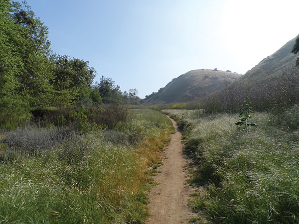
The trail is shared by hikers, equestrians, and mountain bikers. Look for gophers on the canyon hike.
There is a mix of native and nonnative plants. Native plants include coyote brush (baccharus), elderberry, miner’s lettuce, black sage, tarragon, fuchsia-flowering gooseberry, lemonade berry, laurel sumac, blue-eyed grass, California and San Diego sunflowers, monkey flower, and wild cucumber. The green, spiny fruit of the wild cucumber has a striking appearance. Plants such as plantain (a very low-growing, small monocot), blackberry, jimson weed, and thistles can be either native or non-native, depending on the species. Nonnatives (some from the region’s cattle-herding history) include rye grass, oats, wild geranium, black mustard, horehound, curly dock, pineapple weed, plus various filaree species.
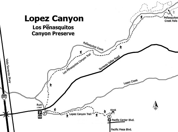
There are many gopher holes lining the trail, and you may see one poking its head out of a hole. Funnel weaver spiders take advantage of vacant gopher holes to set up their nests as well as dotting the hillsides with their funnel-shaped webs. If you go early in the morning, the webs glisten with dew. The trail ends to the right of the kiosk and uphill to the Pacific Mesa Boulevard cul-de-sac near the intersection of Pacific Center Boulevard, where limited parking and some seating areas provide for a leisurely lunch before returning to the west entrance.
An alternate route is to add an additional 5 miles by then following the trail under the Sorrento Valley Boulevard bridge to the waterfalls. The waterfall hike at Los Peñasquitos (little cliffs) Canyon Preserve offers a welcome retreat without a long drive or strenuous exertion to get there. The preserve spans 3700 acres with over 10 miles of trails. Be aware that you will share the trail with horses and bikers throughout the preserve, so be alert to whoever shows up ahead of you or behind you. Wildlife does include coyote and mountain lion; so hiking with a partner is prudent.
The relatively flat trail immediately offers numerous native plant species to view. Black sage perfumes the trail, sharing space with scrub oak, coast live oak, chaparral broom, chamise, manzanita, California sagebrush, checkerbloom, yucca, prickly pear, chalk dudlia, buckwheat, and many other species flowering at various intervals through the spring, summer, and fall. The trail has limited shade, so be sure to bring water, sun protection, and sturdy hiking shoes with good ankle support. Much of the route is lined with rounded, ancient river rock, carried from the Sonora, Mexico region by the San Andreas Fault over millions of years of seismic activity. As you near the junction to the waterfall, looking to the right up the hill will reveal a red shelf-like structure capping lighter colored rock. This is a Linda Vista rock formation, originating from ancient, iron-rich shoreline deposits again originating in Mexico and carried north over time by seismic fault motion. Wend your way carefully over the rocks to get down to the water. Return via the same trail.
For more information on the Los Peñasquitos Canyon Preserve, see the link to the area map at penasquitos.org. The park may be closed during heavy rains or a couple of days following rain. Normal park hours are 8:00 am to sunset.
Distance from downtown San Diego: 16 miles. Allow 25 minutes driving time. From I-805 N, exit on Mira Mesa/Sorrento Parkway then keep in the left lane and go straight through the intersection. Continue north to Sorrento Valley Boulevard and turn right. Roughly a mile later, the park entrance will be on the right. Keep a sharp lookout since the Los Peñasquitos Canyon Preserve sign is not visible until you are almost on it, and you will not be able to make a U-turn for about another mile down the road.
Hiking length: About 2.5 miles from the west end to Pacific Mesa Blvd and return or 7.5 miles, combining the Lopez Canyon section plus the falls and back. Difficulty: Moderate — approximately 120 feet change in elevation with short creek crossings over round rocks.
Here's something you might be interested in.
Lopez Canyon, Los Peñasquitos Canyon Preserve
Lopez Canyon, Los Peñasquitos Canyon Preserve
The hike begins with a pleasant canopy of sycamore, mule fat, willow, and other riparian plants that line Lopez Creek. The trail sometimes crosses the creek, so watch your balance on wet rocks. Poison oak thrives here in large stands and up on sycamore trees, so know how to recognize it before you go. Despite the plant’s toxic nature, it can be lush and beautiful.
The trail is shared by hikers, equestrians, and mountain bikers. Look for gophers on the canyon hike.
There is a mix of native and nonnative plants. Native plants include coyote brush (baccharus), elderberry, miner’s lettuce, black sage, tarragon, fuchsia-flowering gooseberry, lemonade berry, laurel sumac, blue-eyed grass, California and San Diego sunflowers, monkey flower, and wild cucumber. The green, spiny fruit of the wild cucumber has a striking appearance. Plants such as plantain (a very low-growing, small monocot), blackberry, jimson weed, and thistles can be either native or non-native, depending on the species. Nonnatives (some from the region’s cattle-herding history) include rye grass, oats, wild geranium, black mustard, horehound, curly dock, pineapple weed, plus various filaree species.
There are many gopher holes lining the trail, and you may see one poking its head out of a hole. Funnel weaver spiders take advantage of vacant gopher holes to set up their nests as well as dotting the hillsides with their funnel-shaped webs. If you go early in the morning, the webs glisten with dew. The trail ends to the right of the kiosk and uphill to the Pacific Mesa Boulevard cul-de-sac near the intersection of Pacific Center Boulevard, where limited parking and some seating areas provide for a leisurely lunch before returning to the west entrance.
An alternate route is to add an additional 5 miles by then following the trail under the Sorrento Valley Boulevard bridge to the waterfalls. The waterfall hike at Los Peñasquitos (little cliffs) Canyon Preserve offers a welcome retreat without a long drive or strenuous exertion to get there. The preserve spans 3700 acres with over 10 miles of trails. Be aware that you will share the trail with horses and bikers throughout the preserve, so be alert to whoever shows up ahead of you or behind you. Wildlife does include coyote and mountain lion; so hiking with a partner is prudent.
The relatively flat trail immediately offers numerous native plant species to view. Black sage perfumes the trail, sharing space with scrub oak, coast live oak, chaparral broom, chamise, manzanita, California sagebrush, checkerbloom, yucca, prickly pear, chalk dudlia, buckwheat, and many other species flowering at various intervals through the spring, summer, and fall. The trail has limited shade, so be sure to bring water, sun protection, and sturdy hiking shoes with good ankle support. Much of the route is lined with rounded, ancient river rock, carried from the Sonora, Mexico region by the San Andreas Fault over millions of years of seismic activity. As you near the junction to the waterfall, looking to the right up the hill will reveal a red shelf-like structure capping lighter colored rock. This is a Linda Vista rock formation, originating from ancient, iron-rich shoreline deposits again originating in Mexico and carried north over time by seismic fault motion. Wend your way carefully over the rocks to get down to the water. Return via the same trail.
For more information on the Los Peñasquitos Canyon Preserve, see the link to the area map at penasquitos.org. The park may be closed during heavy rains or a couple of days following rain. Normal park hours are 8:00 am to sunset.
Distance from downtown San Diego: 16 miles. Allow 25 minutes driving time. From I-805 N, exit on Mira Mesa/Sorrento Parkway then keep in the left lane and go straight through the intersection. Continue north to Sorrento Valley Boulevard and turn right. Roughly a mile later, the park entrance will be on the right. Keep a sharp lookout since the Los Peñasquitos Canyon Preserve sign is not visible until you are almost on it, and you will not be able to make a U-turn for about another mile down the road.
Hiking length: About 2.5 miles from the west end to Pacific Mesa Blvd and return or 7.5 miles, combining the Lopez Canyon section plus the falls and back. Difficulty: Moderate — approximately 120 feet change in elevation with short creek crossings over round rocks.
Comments