Here's something you might be interested in.
Ask a Hipster — Advice you didn't know you needed
Big Screen — Movie commentary
Blurt — Music's inside track
Booze News — San Diego spirits
Classical Music — Immortal beauty
Classifieds — Free and easy
Close to Home — What it’s like on the street where you live
Cover Stories — Front-page features
Drinks All Around — Bartenders' drink recipes
Excerpts — Literary and spiritual excerpts
Feast! — Food & drink reviews
Feature Stories — Local news & stories
Fishing Report — What’s getting hooked from ship and shore
From the Archives — Spotlight on the past
Golden Dreams — Talk of the town
The Gonzo Report — Making the musical scene, or at least reporting from it
Letters — Our inbox
Movies@Home — Local movie buffs share favorites
Movie Reviews — Our critics' picks and pans
Musician Interviews — Up close with local artists
Neighborhood News from Stringers — Hyperlocal news
News Ticker — News & politics
Obermeyer — San Diego politics illustrated
Outdoors — Weekly changes in flora and fauna
Overheard in San Diego — Eavesdropping illustrated
Poetry — The old and the new
Reader Travel — Travel section built by travelers
Reading — The hunt for intellectuals
Roam-O-Rama — SoCal's best hiking/biking trails
San Diego Beer — Inside San Diego suds
SD on the QT — Almost factual news
Sheep and Goats — Places of worship
Special Issues — The best of
Street Style — San Diego streets have style
Surf Diego — Real stories from those braving the waves
Theater — On stage in San Diego this week
Tin Fork — Silver spoon alternative
Under the Radar — Matt Potter's undercover work
Unforgettable — Long-ago San Diego
Unreal Estate — San Diego's priciest pads
Your Week — Daily event picks
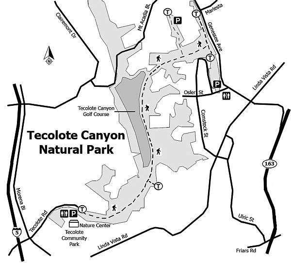
Tecolote Canyon Natural Park
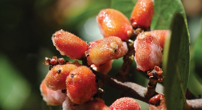
The walks along the trails or access road pass through good examples of coastal sage scrub, chaparral, and riparian habitats.
Tecolote Canyon, featured on area maps for almost 200 years, is designated as a natural park 6 miles in length, .25 to .5-mile wide, with a 2-mile tributary totaling just over 900 acres. Elevations range from sea level at the canyon mouth to 320 feet at the head of Tecolote Canyon. The canyon rim is between 315 and 400 feet above sea level.
The geology of the park consists primarily of marine and non-marine sedimentary rocks of the Scripps and Friars Formations of the Eocene Age (45–50 mya). These rocks make up the canyon walls, with Quaternary (1.8 mya) sedimentary rocks capping the mesas. The exception is at the canyon mouth where the northern wall into Bay Park consists of sediments of the Bay Point Formation of the Quaternary Age (200,000 years). The Tecolote recreation center sits on marine sandstone of the San Diego Formation of Pliocene Age (2–3 mya). The canyon floor consists of Holocene (recent) alluvium and slope wash.
Four faults have been mapped in the park, all located near the mouth. Behind the fence at center field of the upper baseball field, the Rose Canyon Fault can be seen where the margins show 50 mya Eocene sandstone of the Scripps Formation against red stippled Pleistocene conglomerate of only a half-million years. The Rose Canyon Fault parallels the San Andreas Fault, extending north through La Jolla shores.
Once past the baseball fields and nature center, follow the access road or trails that parallel first the water channel, then in the direction of the power lines to the end of the golf course, and then east to Genesee Ave. and back. The 4-mile walk turn-around point is at the peak of the hill under the power lines that overlooks the golf course. The longer hike follows the trail closest to the golf course. At the end of the course, turn east to Genesee Ave. and then head back.
Along the trail, look for evidence of owls that the canyon is named for or other birds that include California thrashers, house wrens, hawks, towhees, and ravens. The walk along the trails and/or access road is a combination of good examples of coastal sage scrub, chaparral, and riparian habitats mixed with erosion and power lines.
Tecolote Creek, north of the golf course, can run to a depth of 6–8 feet during the rainy season. In the summertime, the creek is normally dry, except for runoff from the course greens. The creek empties into Mission Bay at the Pacific Passage side of Fiesta Island. The creek also contributes to the groundwater table in the lower end of the canyon.
In 1957, the city government planned to use Tecolote Canyon as a sanitary landfill; cattle had grazed there until 1953. This and other development plans were abandoned due to protests from residents of Linda Vista and Clairemont, which led to the Park Procedural Ordinance adopted by the San Diego City Council in 1969. The Tecolote Canyon Park District was initiated by the council in January 1971, then adopted in July 1974, both by a unanimous vote. After the land acquisition was completed, the dedication ceremony was held on April 1, 1978.
Distance from downtown San Diego: Approximately 6 miles. From I-5 take exit 21 for Sea World Dr./Tecolote Rd. Turn right onto Tecolote Rd. and within a mile park is the nature center. The Tecolote Nature Center, when open, has facilities and water.
Hiking length: The hike described here is 4 miles, though it can be extended to a 6.5 hike if the trail is followed close to the intersection of Genesse Ave. and Marlesta Dr. and back.
Difficulty: Easy to moderate (depending on distance walked), with an elevation gain near 400 feet.
Here's something you might be interested in.
Tecolote Canyon Natural Park
Tecolote Canyon Natural Park
The walks along the trails or access road pass through good examples of coastal sage scrub, chaparral, and riparian habitats.
Tecolote Canyon, featured on area maps for almost 200 years, is designated as a natural park 6 miles in length, .25 to .5-mile wide, with a 2-mile tributary totaling just over 900 acres. Elevations range from sea level at the canyon mouth to 320 feet at the head of Tecolote Canyon. The canyon rim is between 315 and 400 feet above sea level.
The geology of the park consists primarily of marine and non-marine sedimentary rocks of the Scripps and Friars Formations of the Eocene Age (45–50 mya). These rocks make up the canyon walls, with Quaternary (1.8 mya) sedimentary rocks capping the mesas. The exception is at the canyon mouth where the northern wall into Bay Park consists of sediments of the Bay Point Formation of the Quaternary Age (200,000 years). The Tecolote recreation center sits on marine sandstone of the San Diego Formation of Pliocene Age (2–3 mya). The canyon floor consists of Holocene (recent) alluvium and slope wash.
Four faults have been mapped in the park, all located near the mouth. Behind the fence at center field of the upper baseball field, the Rose Canyon Fault can be seen where the margins show 50 mya Eocene sandstone of the Scripps Formation against red stippled Pleistocene conglomerate of only a half-million years. The Rose Canyon Fault parallels the San Andreas Fault, extending north through La Jolla shores.
Once past the baseball fields and nature center, follow the access road or trails that parallel first the water channel, then in the direction of the power lines to the end of the golf course, and then east to Genesee Ave. and back. The 4-mile walk turn-around point is at the peak of the hill under the power lines that overlooks the golf course. The longer hike follows the trail closest to the golf course. At the end of the course, turn east to Genesee Ave. and then head back.
Along the trail, look for evidence of owls that the canyon is named for or other birds that include California thrashers, house wrens, hawks, towhees, and ravens. The walk along the trails and/or access road is a combination of good examples of coastal sage scrub, chaparral, and riparian habitats mixed with erosion and power lines.
Tecolote Creek, north of the golf course, can run to a depth of 6–8 feet during the rainy season. In the summertime, the creek is normally dry, except for runoff from the course greens. The creek empties into Mission Bay at the Pacific Passage side of Fiesta Island. The creek also contributes to the groundwater table in the lower end of the canyon.
In 1957, the city government planned to use Tecolote Canyon as a sanitary landfill; cattle had grazed there until 1953. This and other development plans were abandoned due to protests from residents of Linda Vista and Clairemont, which led to the Park Procedural Ordinance adopted by the San Diego City Council in 1969. The Tecolote Canyon Park District was initiated by the council in January 1971, then adopted in July 1974, both by a unanimous vote. After the land acquisition was completed, the dedication ceremony was held on April 1, 1978.
Distance from downtown San Diego: Approximately 6 miles. From I-5 take exit 21 for Sea World Dr./Tecolote Rd. Turn right onto Tecolote Rd. and within a mile park is the nature center. The Tecolote Nature Center, when open, has facilities and water.
Hiking length: The hike described here is 4 miles, though it can be extended to a 6.5 hike if the trail is followed close to the intersection of Genesse Ave. and Marlesta Dr. and back.
Difficulty: Easy to moderate (depending on distance walked), with an elevation gain near 400 feet.
Comments