Here's something you might be interested in.
Ask a Hipster — Advice you didn't know you needed
Big Screen — Movie commentary
Blurt — Music's inside track
Booze News — San Diego spirits
Classical Music — Immortal beauty
Classifieds — Free and easy
Close to Home — What it’s like on the street where you live
Cover Stories — Front-page features
Drinks All Around — Bartenders' drink recipes
Excerpts — Literary and spiritual excerpts
Feast! — Food & drink reviews
Feature Stories — Local news & stories
Fishing Report — What’s getting hooked from ship and shore
From the Archives — Spotlight on the past
Golden Dreams — Talk of the town
The Gonzo Report — Making the musical scene, or at least reporting from it
Letters — Our inbox
Movies@Home — Local movie buffs share favorites
Movie Reviews — Our critics' picks and pans
Musician Interviews — Up close with local artists
Neighborhood News from Stringers — Hyperlocal news
News Ticker — News & politics
Obermeyer — San Diego politics illustrated
Outdoors — Weekly changes in flora and fauna
Overheard in San Diego — Eavesdropping illustrated
Poetry — The old and the new
Reader Travel — Travel section built by travelers
Reading — The hunt for intellectuals
Roam-O-Rama — SoCal's best hiking/biking trails
San Diego Beer — Inside San Diego suds
SD on the QT — Almost factual news
Sheep and Goats — Places of worship
Special Issues — The best of
Street Style — San Diego streets have style
Surf Diego — Real stories from those braving the waves
Theater — On stage in San Diego this week
Tin Fork — Silver spoon alternative
Under the Radar — Matt Potter's undercover work
Unforgettable — Long-ago San Diego
Unreal Estate — San Diego's priciest pads
Your Week — Daily event picks
East Shepherd Canyon
Walk, jog, or bike in this friendly community park that has a pond.
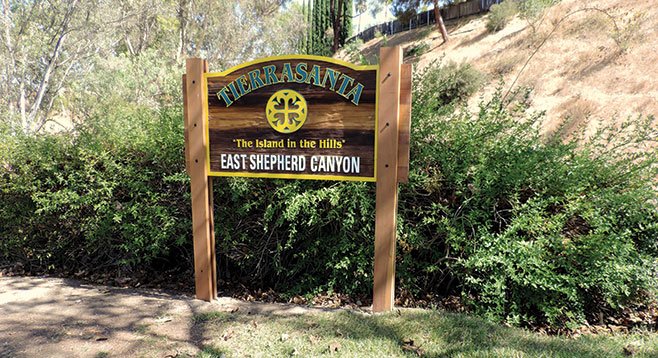
The entrance to East Shepherd Canyon is clearly marked.
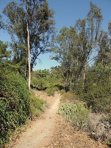
East Shepherd, or Greenbelt, trail is interesting in all seasons, with a combination of native coastal sage scrub and nonnative plants in the canyon. Walk north on Santo Road for about 160 feet, where the trail starts just past the signed gate that separates traffic by a nonnative hedge on the left. The beginning of the hike is a good place to contemplate the history of the area.
The area was first inhabited by the Kumeyaay and then was managed from 1769 to 1833 by the Mission San Diego de Alcalá Franciscans. Under a decree of confiscation in 1834, the mission lands were divided into ranchos and given to officers who fought in the war of independence against Spain. The mission was not restored to the Catholic Church until 1862 by president Abraham Lincoln. In the late 1840s, the old mission lands fell under the use of the U.S. military.
In 1941, Camp Elliot was roughly the shape of a parallelogram within the confines of I-15 northeast to Pomerado Road/Beeler Canyon to Sycamore Canyon before going south to Mission Gorge Rd. and before returning to just west of I-15. Use of the area included tank and artillery training plus communications training for the WWII Navajo Code Talkers (navajocodetalkers.org).
Good place to contemplate the history of the area
Later in 1960, 13,277 acres were annexed into San Diego with different land-use plans finally evolving into East Shepherd Canyon, which became one of San Diego County’s first community parks in the 1980s. Take seriously the warning sign at each point of entry stating there is a possibility of unexploded shells that might still surface in the park.
Just past the entrance gate to the right are laurel sumac, California sagebrush, prickly pear cactus, and black sage. To the left are examples of male and female chaparral broom plants. The male flowers are a cupped, cream color whereas the female flowers are white with long, slender “hairs.” Wind dispersal of the mature seeds can be seen when the plant branches are lightly shaken.
Follow the trail to the right along a small creek, then over a fallen tree trunk to continue. There are a couple crossings where a board has been placed to keep your feet dry. Toyon, an evergreen member of the rose family with its serrated leaf edges and red berries in the fall/winter and white flowers in the spring, are along the trail and redwood fence.
The origin of the name Dishwasher Pond is unknown. The pond is a small body of aerated water where sometimes ducks and damsel and dragonflies can be seen among the willows and cattails. Continue hiking under eucalyptus trees to Via Valera, then return.
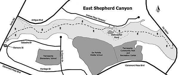
Distance from downtown San Diego: About 11 miles. Allow 20 minutes driving time (Tierrasanta). From CA-163N, take I-8E then CA-15N. Exit east onto Clairemont Mesa Blvd., then go north on Santo Rd. Take an abrupt turn onto Remora St. to park. No facilities.
Hiking length: Approximately 3 miles.
Difficulty: Easy with less than 200 feet elevation loss/gain. The trail is mostly wide, hard-packed soil with a couple of wooden planks to cross water. Hikers, dogs on leashes, and bicycles are allowed.
Here's something you might be interested in.
East Shepherd Canyon
Walk, jog, or bike in this friendly community park that has a pond.
East Shepherd Canyon
Walk, jog, or bike in this friendly community park that has a pond.
The entrance to East Shepherd Canyon is clearly marked.
East Shepherd, or Greenbelt, trail is interesting in all seasons, with a combination of native coastal sage scrub and nonnative plants in the canyon. Walk north on Santo Road for about 160 feet, where the trail starts just past the signed gate that separates traffic by a nonnative hedge on the left. The beginning of the hike is a good place to contemplate the history of the area.
The area was first inhabited by the Kumeyaay and then was managed from 1769 to 1833 by the Mission San Diego de Alcalá Franciscans. Under a decree of confiscation in 1834, the mission lands were divided into ranchos and given to officers who fought in the war of independence against Spain. The mission was not restored to the Catholic Church until 1862 by president Abraham Lincoln. In the late 1840s, the old mission lands fell under the use of the U.S. military.
In 1941, Camp Elliot was roughly the shape of a parallelogram within the confines of I-15 northeast to Pomerado Road/Beeler Canyon to Sycamore Canyon before going south to Mission Gorge Rd. and before returning to just west of I-15. Use of the area included tank and artillery training plus communications training for the WWII Navajo Code Talkers (navajocodetalkers.org).
Good place to contemplate the history of the area
Later in 1960, 13,277 acres were annexed into San Diego with different land-use plans finally evolving into East Shepherd Canyon, which became one of San Diego County’s first community parks in the 1980s. Take seriously the warning sign at each point of entry stating there is a possibility of unexploded shells that might still surface in the park.
Just past the entrance gate to the right are laurel sumac, California sagebrush, prickly pear cactus, and black sage. To the left are examples of male and female chaparral broom plants. The male flowers are a cupped, cream color whereas the female flowers are white with long, slender “hairs.” Wind dispersal of the mature seeds can be seen when the plant branches are lightly shaken.
Follow the trail to the right along a small creek, then over a fallen tree trunk to continue. There are a couple crossings where a board has been placed to keep your feet dry. Toyon, an evergreen member of the rose family with its serrated leaf edges and red berries in the fall/winter and white flowers in the spring, are along the trail and redwood fence.
The origin of the name Dishwasher Pond is unknown. The pond is a small body of aerated water where sometimes ducks and damsel and dragonflies can be seen among the willows and cattails. Continue hiking under eucalyptus trees to Via Valera, then return.
Distance from downtown San Diego: About 11 miles. Allow 20 minutes driving time (Tierrasanta). From CA-163N, take I-8E then CA-15N. Exit east onto Clairemont Mesa Blvd., then go north on Santo Rd. Take an abrupt turn onto Remora St. to park. No facilities.
Hiking length: Approximately 3 miles.
Difficulty: Easy with less than 200 feet elevation loss/gain. The trail is mostly wide, hard-packed soil with a couple of wooden planks to cross water. Hikers, dogs on leashes, and bicycles are allowed.
Comments