Here's something you might be interested in.
Ask a Hipster — Advice you didn't know you needed
Big Screen — Movie commentary
Blurt — Music's inside track
Booze News — San Diego spirits
Classical Music — Immortal beauty
Classifieds — Free and easy
Close to Home — What it’s like on the street where you live
Cover Stories — Front-page features
Drinks All Around — Bartenders' drink recipes
Excerpts — Literary and spiritual excerpts
Feast! — Food & drink reviews
Feature Stories — Local news & stories
Fishing Report — What’s getting hooked from ship and shore
From the Archives — Spotlight on the past
Golden Dreams — Talk of the town
The Gonzo Report — Making the musical scene, or at least reporting from it
Letters — Our inbox
Movies@Home — Local movie buffs share favorites
Movie Reviews — Our critics' picks and pans
Musician Interviews — Up close with local artists
Neighborhood News from Stringers — Hyperlocal news
News Ticker — News & politics
Obermeyer — San Diego politics illustrated
Outdoors — Weekly changes in flora and fauna
Overheard in San Diego — Eavesdropping illustrated
Poetry — The old and the new
Reader Travel — Travel section built by travelers
Reading — The hunt for intellectuals
Roam-O-Rama — SoCal's best hiking/biking trails
San Diego Beer — Inside San Diego suds
SD on the QT — Almost factual news
Sheep and Goats — Places of worship
Special Issues — The best of
Street Style — San Diego streets have style
Surf Diego — Real stories from those braving the waves
Theater — On stage in San Diego this week
Tin Fork — Silver spoon alternative
Under the Radar — Matt Potter's undercover work
Unforgettable — Long-ago San Diego
Unreal Estate — San Diego's priciest pads
Your Week — Daily event picks
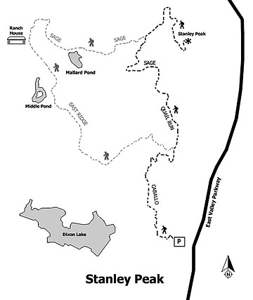
Daley Ranch’s Caballo Trail to Stanley Peak
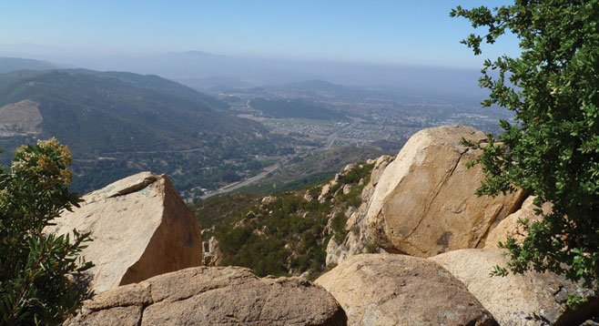
The 1983-foot Stanley Peak offers wide views of Escondido and beyond.
Daley Ranch in Escondido is a 3000+ acre public preserve of hills, mountains, ponds, and seasonal streams with over 20 miles of trails for hiking, mountain biking, running, and equestrian use. Although surrounded by suburban and semi-rural developments, it is sufficiently large and diverse.
There are four entrances to the network of ranch trails. Most people enter the park from the main entrance off El Norte Parkway, near the end of La Honda Drive. All ranch trails interconnect and eventually any point can be reached from the large parking area near the main entrance, but for the hike described here, use the entrance off Valley Center Road. It takes you directly to the Caballo Trail head.
From the parking area, the Caballo trail starts near an abandoned avocado grove, then goes up the east-facing slope of an unnamed canyon through which an intermittent stream flows. A dense growth of coastal sage and chaparral covers the hillsides. Depending on the year and the season of your visit, you can expect to find a colorful display of blooming annuals and shrubs, including mission manzanita, Ramona lilac, chamise, laurel sumac, buckbrush, California poppy, white and black sage, bush monkey flower, lupines, penstemon, deer brush, buckwheat, and many others.
At about a mile, the trail forks: the Caballo Trail continues off to the left while the Quail Run Trail begins toward the right. Take the Quail Run Trail and continue up the ridge for a little over half a mile until it connects with the Sage Trail. Go right on the Sage Trail, which actually is a dirt road, badly eroded in spots, but easily navigated on foot. After traveling about three-quarters of a mile on the Sage Trail, the Stanley Peak Trail is visible. Initially this is an easy walk along the edge of a meadow, with a scattering of rather small Engelmann oak trees. However, as you get closer to your goal, the trail begins to climb steeply to the top of the boulder-covered, 1983-foot Stanley Peak, the high point of the Daley Ranch. After taking in the view you may reverse your steps to return to your car or explore some of the other interesting nearby parts of the park, such as Mallard Pond or the historic ranch house, before returning.
Distance from downtown San Diego: 37 miles. Allow 45 minutes’ driving time. Go north on Hwy 163, merge onto I-15, and continue north to Escondido. Exit at El Norte Parkway and go east 5 miles, then make a left on Valley Parkway (which becomes Valley Center Road). At the second signal, make another left on Beven Ln, go about 200 yards, cross a bridge, and make a right on Save-a-Life Ln. There will be signs for both the Humane Society and for the Caballo Trail. There is ample parking at the trailhead but no facilities or water.
Hiking length: 5.4 miles.
Difficulty: Moderate, with a little over 1000 ft total elevation gain/loss. The trails are well maintained and marked. The main danger is not bringing enough water on a hot day. You may occasionally see (and need to avoid) rattlesnakes and poison oak.
Canyoneers are San Diego Natural History Museum volunteers trained to lead interpretive nature walks that teach appreciation for the great outdoors. For a schedule of free public hikes:
http://www.sdnhm.org/education/naturalists-of-all-ages/canyoneer-hikes/
Here's something you might be interested in.
Daley Ranch’s Caballo Trail to Stanley Peak
Daley Ranch’s Caballo Trail to Stanley Peak
The 1983-foot Stanley Peak offers wide views of Escondido and beyond.
Daley Ranch in Escondido is a 3000+ acre public preserve of hills, mountains, ponds, and seasonal streams with over 20 miles of trails for hiking, mountain biking, running, and equestrian use. Although surrounded by suburban and semi-rural developments, it is sufficiently large and diverse.
There are four entrances to the network of ranch trails. Most people enter the park from the main entrance off El Norte Parkway, near the end of La Honda Drive. All ranch trails interconnect and eventually any point can be reached from the large parking area near the main entrance, but for the hike described here, use the entrance off Valley Center Road. It takes you directly to the Caballo Trail head.
From the parking area, the Caballo trail starts near an abandoned avocado grove, then goes up the east-facing slope of an unnamed canyon through which an intermittent stream flows. A dense growth of coastal sage and chaparral covers the hillsides. Depending on the year and the season of your visit, you can expect to find a colorful display of blooming annuals and shrubs, including mission manzanita, Ramona lilac, chamise, laurel sumac, buckbrush, California poppy, white and black sage, bush monkey flower, lupines, penstemon, deer brush, buckwheat, and many others.
At about a mile, the trail forks: the Caballo Trail continues off to the left while the Quail Run Trail begins toward the right. Take the Quail Run Trail and continue up the ridge for a little over half a mile until it connects with the Sage Trail. Go right on the Sage Trail, which actually is a dirt road, badly eroded in spots, but easily navigated on foot. After traveling about three-quarters of a mile on the Sage Trail, the Stanley Peak Trail is visible. Initially this is an easy walk along the edge of a meadow, with a scattering of rather small Engelmann oak trees. However, as you get closer to your goal, the trail begins to climb steeply to the top of the boulder-covered, 1983-foot Stanley Peak, the high point of the Daley Ranch. After taking in the view you may reverse your steps to return to your car or explore some of the other interesting nearby parts of the park, such as Mallard Pond or the historic ranch house, before returning.
Distance from downtown San Diego: 37 miles. Allow 45 minutes’ driving time. Go north on Hwy 163, merge onto I-15, and continue north to Escondido. Exit at El Norte Parkway and go east 5 miles, then make a left on Valley Parkway (which becomes Valley Center Road). At the second signal, make another left on Beven Ln, go about 200 yards, cross a bridge, and make a right on Save-a-Life Ln. There will be signs for both the Humane Society and for the Caballo Trail. There is ample parking at the trailhead but no facilities or water.
Hiking length: 5.4 miles.
Difficulty: Moderate, with a little over 1000 ft total elevation gain/loss. The trails are well maintained and marked. The main danger is not bringing enough water on a hot day. You may occasionally see (and need to avoid) rattlesnakes and poison oak.
Canyoneers are San Diego Natural History Museum volunteers trained to lead interpretive nature walks that teach appreciation for the great outdoors. For a schedule of free public hikes:
http://www.sdnhm.org/education/naturalists-of-all-ages/canyoneer-hikes/
Comments