Here's something you might be interested in.
Ask a Hipster — Advice you didn't know you needed
Big Screen — Movie commentary
Blurt — Music's inside track
Booze News — San Diego spirits
Classical Music — Immortal beauty
Classifieds — Free and easy
Close to Home — What it’s like on the street where you live
Cover Stories — Front-page features
Drinks All Around — Bartenders' drink recipes
Excerpts — Literary and spiritual excerpts
Feast! — Food & drink reviews
Feature Stories — Local news & stories
Fishing Report — What’s getting hooked from ship and shore
From the Archives — Spotlight on the past
Golden Dreams — Talk of the town
The Gonzo Report — Making the musical scene, or at least reporting from it
Letters — Our inbox
Movies@Home — Local movie buffs share favorites
Movie Reviews — Our critics' picks and pans
Musician Interviews — Up close with local artists
Neighborhood News from Stringers — Hyperlocal news
News Ticker — News & politics
Obermeyer — San Diego politics illustrated
Outdoors — Weekly changes in flora and fauna
Overheard in San Diego — Eavesdropping illustrated
Poetry — The old and the new
Reader Travel — Travel section built by travelers
Reading — The hunt for intellectuals
Roam-O-Rama — SoCal's best hiking/biking trails
San Diego Beer — Inside San Diego suds
SD on the QT — Almost factual news
Sheep and Goats — Places of worship
Special Issues — The best of
Street Style — San Diego streets have style
Surf Diego — Real stories from those braving the waves
Theater — On stage in San Diego this week
Tin Fork — Silver spoon alternative
Under the Radar — Matt Potter's undercover work
Unforgettable — Long-ago San Diego
Unreal Estate — San Diego's priciest pads
Your Week — Daily event picks
Calcite Mine and Slot Canyon
Hike an amazing slot canyon, visit an abandoned calcite mine, and enjoy panoramic desert views.
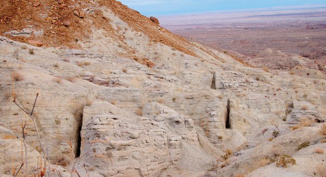
Calcite extracted from these trenches during WWII was used in the manufacturing of Norden bombsights.
Distance from downtown San Diego: 104 miles. Allow almost 3 hours’ driving time (Anza-Borrego Desert State Park). From Ramona, drive east on Hwy 78, turn left on Hwy 79, right on San Felipe Road (S2), and left on Montezuma Road (S22). Turn right on Palm Canyon Drive following the Borrego-Salton Seaway (S22) 19 miles past Christmas Circle in Borrego Springs to mile marker 34. Park on the north side of the highway.
Hiking length: 4 miles round trip
Difficulty: Easy to moderate, with about 800 feet of elevation gain/loss. There are no facilities or water on this trip.
Leave your car at the parking area at the top of the canyon to not miss the slot canyon that leads to an abandoned site where calcite crystals were mined during WWII. Vehicles driving to the site will miss the slot canyon. The four-wheel-drive-only road is treacherous and not recommended. Panoramic views of the Salton Sea to the east and the Borrego Badlands to the south are visible during this hike.
Begin from the parking area on the north side of S22 at mile marker 34 where a truck trail descends sharply into the South Fork of Palm Wash. Cross the wash and proceed northwest up the hill. Approximately .75 mile from S22 will be a signed junction. The road to the left continues on up the hill to the mine while the one on the right goes down to the Palm Wash truck trail and provides another way to get to the mine site while hiking through an amazing slot canyon that reveals the sedimentary history of these mountains. When you reach the sandy wash, go left up the wash. After about a quarter of a mile, the truck trail ends at a point where the main wash is choked with some huge boulders. The slot canyon leads off to the left at this point. The hike through this canyon leads back to the Calcite Mine truck trail at a point about 1.5 miles from the start of the hike. The slot canyon continues north on the other side of the road, should you have time and want to explore some more. For those with limited time, once you reach the road turn right and take the road uphill for another half-mile to the mine site.
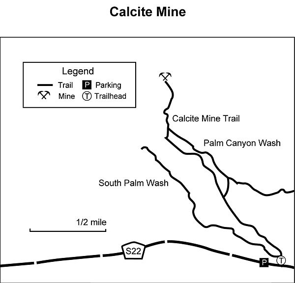
Calcite Mine Map
Calcite was an essential component of the Norden bombsight. It was mined by digging trenches along calcite-containing seams. The trenches can be recognized by their unnatural regularity. Look around and note small calcite crystals everywhere glittering in the sun light. However, remember that it is illegal to remove any plant, animal or mineral you might find in the park. Look, experiment with the crystals, but leave them here when you are ready to leave. If you find a transparent crystal, look at some printed matter through it to observe the birefringence or double refraction of the crystal.
The Norden bombsight was one of America’s most closely guarded secrets during World War II. It was the state of the art in the 1940s, used to calculate the trajectory of a bomb being dropped from high altitudes. It enabled American airplanes to hit ground targets in daylight raids from an altitude of six miles.
Calcite is a common mineral, a form of calcium carbonate, similar in basic chemical composition to chalk and gypsum and the basic material for cement. There are at least 800 different forms of crystalline calcite. These differ in color and in light transmission from completely opaque to translucent. The calcite crystals needed for bombsights had to be colorless and transparent, which is the type of calcite found and mined in this area.
Canyoneers are San Diego Natural History Museum volunteers trained to lead interpretive nature walks that teach appreciation for the great outdoors. For a schedule of free public hikes:
http://www.sdnhm.org/education/naturalists-of-all-ages/canyoneer-hikes/
Here's something you might be interested in.
Calcite Mine and Slot Canyon
Hike an amazing slot canyon, visit an abandoned calcite mine, and enjoy panoramic desert views.
Calcite Mine and Slot Canyon
Hike an amazing slot canyon, visit an abandoned calcite mine, and enjoy panoramic desert views.
Calcite extracted from these trenches during WWII was used in the manufacturing of Norden bombsights.
Distance from downtown San Diego: 104 miles. Allow almost 3 hours’ driving time (Anza-Borrego Desert State Park). From Ramona, drive east on Hwy 78, turn left on Hwy 79, right on San Felipe Road (S2), and left on Montezuma Road (S22). Turn right on Palm Canyon Drive following the Borrego-Salton Seaway (S22) 19 miles past Christmas Circle in Borrego Springs to mile marker 34. Park on the north side of the highway.
Hiking length: 4 miles round trip
Difficulty: Easy to moderate, with about 800 feet of elevation gain/loss. There are no facilities or water on this trip.
Leave your car at the parking area at the top of the canyon to not miss the slot canyon that leads to an abandoned site where calcite crystals were mined during WWII. Vehicles driving to the site will miss the slot canyon. The four-wheel-drive-only road is treacherous and not recommended. Panoramic views of the Salton Sea to the east and the Borrego Badlands to the south are visible during this hike.
Begin from the parking area on the north side of S22 at mile marker 34 where a truck trail descends sharply into the South Fork of Palm Wash. Cross the wash and proceed northwest up the hill. Approximately .75 mile from S22 will be a signed junction. The road to the left continues on up the hill to the mine while the one on the right goes down to the Palm Wash truck trail and provides another way to get to the mine site while hiking through an amazing slot canyon that reveals the sedimentary history of these mountains. When you reach the sandy wash, go left up the wash. After about a quarter of a mile, the truck trail ends at a point where the main wash is choked with some huge boulders. The slot canyon leads off to the left at this point. The hike through this canyon leads back to the Calcite Mine truck trail at a point about 1.5 miles from the start of the hike. The slot canyon continues north on the other side of the road, should you have time and want to explore some more. For those with limited time, once you reach the road turn right and take the road uphill for another half-mile to the mine site.
Calcite Mine Map
Calcite was an essential component of the Norden bombsight. It was mined by digging trenches along calcite-containing seams. The trenches can be recognized by their unnatural regularity. Look around and note small calcite crystals everywhere glittering in the sun light. However, remember that it is illegal to remove any plant, animal or mineral you might find in the park. Look, experiment with the crystals, but leave them here when you are ready to leave. If you find a transparent crystal, look at some printed matter through it to observe the birefringence or double refraction of the crystal.
The Norden bombsight was one of America’s most closely guarded secrets during World War II. It was the state of the art in the 1940s, used to calculate the trajectory of a bomb being dropped from high altitudes. It enabled American airplanes to hit ground targets in daylight raids from an altitude of six miles.
Calcite is a common mineral, a form of calcium carbonate, similar in basic chemical composition to chalk and gypsum and the basic material for cement. There are at least 800 different forms of crystalline calcite. These differ in color and in light transmission from completely opaque to translucent. The calcite crystals needed for bombsights had to be colorless and transparent, which is the type of calcite found and mined in this area.
Canyoneers are San Diego Natural History Museum volunteers trained to lead interpretive nature walks that teach appreciation for the great outdoors. For a schedule of free public hikes:
http://www.sdnhm.org/education/naturalists-of-all-ages/canyoneer-hikes/
Comments