Here's something you might be interested in.
Ask a Hipster — Advice you didn't know you needed
Big Screen — Movie commentary
Blurt — Music's inside track
Booze News — San Diego spirits
Classical Music — Immortal beauty
Classifieds — Free and easy
Close to Home — What it’s like on the street where you live
Cover Stories — Front-page features
Drinks All Around — Bartenders' drink recipes
Excerpts — Literary and spiritual excerpts
Feast! — Food & drink reviews
Feature Stories — Local news & stories
Fishing Report — What’s getting hooked from ship and shore
From the Archives — Spotlight on the past
Golden Dreams — Talk of the town
The Gonzo Report — Making the musical scene, or at least reporting from it
Letters — Our inbox
Movies@Home — Local movie buffs share favorites
Movie Reviews — Our critics' picks and pans
Musician Interviews — Up close with local artists
Neighborhood News from Stringers — Hyperlocal news
News Ticker — News & politics
Obermeyer — San Diego politics illustrated
Outdoors — Weekly changes in flora and fauna
Overheard in San Diego — Eavesdropping illustrated
Poetry — The old and the new
Reader Travel — Travel section built by travelers
Reading — The hunt for intellectuals
Roam-O-Rama — SoCal's best hiking/biking trails
San Diego Beer — Inside San Diego suds
SD on the QT — Almost factual news
Sheep and Goats — Places of worship
Special Issues — The best of
Street Style — San Diego streets have style
Surf Diego — Real stories from those braving the waves
Theater — On stage in San Diego this week
Tin Fork — Silver spoon alternative
Under the Radar — Matt Potter's undercover work
Unforgettable — Long-ago San Diego
Unreal Estate — San Diego's priciest pads
Your Week — Daily event picks
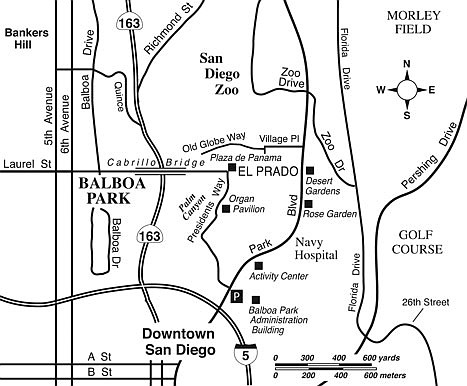
Historical Walk in Balboa Park
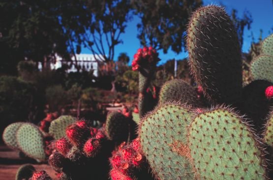
Balboa Park’s desert gardens
The 1915–16 Panama-California Exposition site in Balboa Park is renowned among San Diegans for its incomparably beautiful Spanish-Moorish buildings, its gardens, and the graceful Cabrillo Bridge. That area is the primary destination of the walk described here, which is one of 20 mapped and signed walks being developed throughout Balboa Park’s 1200 acres. You’ll be following signs for Trail 31 throughout. A detailed map of this route (and other park trails) is available at balboapark.org/maps/maps.php.
At the Park Boulevard/Presidents Way intersection, first locate the brand-new trail gateway sign at the northeast corner. Head east on the sidewalk leading directly toward the former Naval Hospital headquarters building —- now the administrative offices for Balboa Park. Climb the stairs, swing left around the headquarters building, and enjoy the pergola-bounded courtyard behind it. Comparatively few people visit this elegantly landscaped space.
From the courtyard, swing north and edge by the Balboa Park Activity Center (table-tennis, badminton, volleyball, and the like practiced inside). You emerge along the sidewalk following Park Boulevard. Continue north along the fenced perimeter of the current Naval Hospital. After a short distance you come upon the spacious Rose Garden, and just past that, the Desert Gardens, a hillside covered with exotic succulent plants from around the world.
At the far north end of the Desert Gardens, you emerge at the intersection of Park Boulevard and Village Place. Cross Park Boulevard at the traffic light there and head west past the massive Moreton Bay fig tree that stands in front of the entrance to the San Diego Natural History Museum.
At the next street crossing, jog slightly left and pick up Old Globe Way on the far side. You skirt the south boundary fence of the San Diego Zoo for a short while and then turn left, just short of the open-lath Botanical Building. Swing alongside the front entrance to the Botanical Building, passing right over the majestically serene Lily Pond. Need we say you should have your camera along?
Just ahead, you reach the park’s central square, Plaza de Panama, bounded by two art museums on the north and various historical structures dating from the 1915–16 Exposition on the south. The plaza is now devoted to parked cars, but it’s slated to be transformed into pedestrian-only gathering space in time for the Exposition’s centennial in 2015.
Following Trail 31 signs (which are plaques embedded in the sidewalk in the park’s historical areas), continue west along El Prado, past the Museum of Man’s lofty California Tower and all the way across the Cabrillo Bridge, using the north-side sidewalk. The 450-foot-long, 120-foot-high bridge, begun in 1912, uses a multiple-arched cantilever structure, which was innovative at that time and timeless in its form.
At the far side of the bridge, cross over the El Prado roadway and pick up the south-side sidewalk for the reverse passage (east) across the bridge. The historic Cabrillo Freeway (the 163) curves below, leading toward the cluster of high-rises that bolsters San Diego’s image as a true city. Many a classic postcard photo was taken from this vantage.
Returning to the California Tower, swing right just ahead for a passage through Alcazar Gardens, and edge along the lushly landscaped upper rim of Palm Canyon. You cross over Presidents Way and skirt the Organ Pavilion, which houses one of the world’s largest pipe organs. Travel north from there past the Japanese Friendship Garden, and return to Plaza de Panama.
Make a right now, and go east on the traffic-free section of El Prado, passing museums on both sides. Continue all the way to the circular fountain. Finally, make your way down to the west-side sidewalk on Park Boulevard, swing right, and follow that sidewalk back to the corner of Park Boulevard and Presidents Way, your starting point.
Historical Walk in Balboa Park
A newly signed trail route in Balboa Park highlights familiar and obscure park spaces.
Distance from downtown San Diego: 1 mile
Hiking length: 3.0 miles round trip
Difficulty: Easy
Here's something you might be interested in.
Historical Walk in Balboa Park
Historical Walk in Balboa Park
Balboa Park’s desert gardens
The 1915–16 Panama-California Exposition site in Balboa Park is renowned among San Diegans for its incomparably beautiful Spanish-Moorish buildings, its gardens, and the graceful Cabrillo Bridge. That area is the primary destination of the walk described here, which is one of 20 mapped and signed walks being developed throughout Balboa Park’s 1200 acres. You’ll be following signs for Trail 31 throughout. A detailed map of this route (and other park trails) is available at balboapark.org/maps/maps.php.
At the Park Boulevard/Presidents Way intersection, first locate the brand-new trail gateway sign at the northeast corner. Head east on the sidewalk leading directly toward the former Naval Hospital headquarters building —- now the administrative offices for Balboa Park. Climb the stairs, swing left around the headquarters building, and enjoy the pergola-bounded courtyard behind it. Comparatively few people visit this elegantly landscaped space.
From the courtyard, swing north and edge by the Balboa Park Activity Center (table-tennis, badminton, volleyball, and the like practiced inside). You emerge along the sidewalk following Park Boulevard. Continue north along the fenced perimeter of the current Naval Hospital. After a short distance you come upon the spacious Rose Garden, and just past that, the Desert Gardens, a hillside covered with exotic succulent plants from around the world.
At the far north end of the Desert Gardens, you emerge at the intersection of Park Boulevard and Village Place. Cross Park Boulevard at the traffic light there and head west past the massive Moreton Bay fig tree that stands in front of the entrance to the San Diego Natural History Museum.
At the next street crossing, jog slightly left and pick up Old Globe Way on the far side. You skirt the south boundary fence of the San Diego Zoo for a short while and then turn left, just short of the open-lath Botanical Building. Swing alongside the front entrance to the Botanical Building, passing right over the majestically serene Lily Pond. Need we say you should have your camera along?
Just ahead, you reach the park’s central square, Plaza de Panama, bounded by two art museums on the north and various historical structures dating from the 1915–16 Exposition on the south. The plaza is now devoted to parked cars, but it’s slated to be transformed into pedestrian-only gathering space in time for the Exposition’s centennial in 2015.
Following Trail 31 signs (which are plaques embedded in the sidewalk in the park’s historical areas), continue west along El Prado, past the Museum of Man’s lofty California Tower and all the way across the Cabrillo Bridge, using the north-side sidewalk. The 450-foot-long, 120-foot-high bridge, begun in 1912, uses a multiple-arched cantilever structure, which was innovative at that time and timeless in its form.
At the far side of the bridge, cross over the El Prado roadway and pick up the south-side sidewalk for the reverse passage (east) across the bridge. The historic Cabrillo Freeway (the 163) curves below, leading toward the cluster of high-rises that bolsters San Diego’s image as a true city. Many a classic postcard photo was taken from this vantage.
Returning to the California Tower, swing right just ahead for a passage through Alcazar Gardens, and edge along the lushly landscaped upper rim of Palm Canyon. You cross over Presidents Way and skirt the Organ Pavilion, which houses one of the world’s largest pipe organs. Travel north from there past the Japanese Friendship Garden, and return to Plaza de Panama.
Make a right now, and go east on the traffic-free section of El Prado, passing museums on both sides. Continue all the way to the circular fountain. Finally, make your way down to the west-side sidewalk on Park Boulevard, swing right, and follow that sidewalk back to the corner of Park Boulevard and Presidents Way, your starting point.
Historical Walk in Balboa Park
A newly signed trail route in Balboa Park highlights familiar and obscure park spaces.
Distance from downtown San Diego: 1 mile
Hiking length: 3.0 miles round trip
Difficulty: Easy