Here's something you might be interested in.
Ask a Hipster — Advice you didn't know you needed
Big Screen — Movie commentary
Blurt — Music's inside track
Booze News — San Diego spirits
Classical Music — Immortal beauty
Classifieds — Free and easy
Close to Home — What it’s like on the street where you live
Cover Stories — Front-page features
Drinks All Around — Bartenders' drink recipes
Excerpts — Literary and spiritual excerpts
Feast! — Food & drink reviews
Feature Stories — Local news & stories
Fishing Report — What’s getting hooked from ship and shore
From the Archives — Spotlight on the past
Golden Dreams — Talk of the town
The Gonzo Report — Making the musical scene, or at least reporting from it
Letters — Our inbox
Movies@Home — Local movie buffs share favorites
Movie Reviews — Our critics' picks and pans
Musician Interviews — Up close with local artists
Neighborhood News from Stringers — Hyperlocal news
News Ticker — News & politics
Obermeyer — San Diego politics illustrated
Outdoors — Weekly changes in flora and fauna
Overheard in San Diego — Eavesdropping illustrated
Poetry — The old and the new
Reader Travel — Travel section built by travelers
Reading — The hunt for intellectuals
Roam-O-Rama — SoCal's best hiking/biking trails
San Diego Beer — Inside San Diego suds
SD on the QT — Almost factual news
Sheep and Goats — Places of worship
Special Issues — The best of
Street Style — San Diego streets have style
Surf Diego — Real stories from those braving the waves
Theater — On stage in San Diego this week
Tin Fork — Silver spoon alternative
Under the Radar — Matt Potter's undercover work
Unforgettable — Long-ago San Diego
Unreal Estate — San Diego's priciest pads
Your Week — Daily event picks
O'Melveny Park
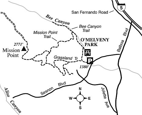
O’Melveny Park spreads over 672 acres, second on the list of largest parks within the City of Los Angeles, right after the much-more-spacious Griffith Park. Noted for its picture-perfect picnic grounds with white fences and towering eucalyptus trees, O’Melveny Park also challenges hikers with several miles of steep, backcountry fire roads and primitive trails. The route profile here (five miles, with an elevation gain and loss of about 1500 feet) constitutes a comprehensive walking tour that includes a high point in the Santa Susana Mountains known as Mission Point.
To get there, exit the 118 freeway at Balboa Boulevard in Granada Hills. Drive north two miles to Sesnon Boulevard. Go left (west) and continue 0.6 mile to the parking lot for O’Melveny Park on the right.
Start your hike on the Grassland Trail, west of the park office. The trail darts up a narrow, almost barren ridge dividing two parallel ravines. Native California walnut trees dot the bottoms of these ravines. Chances are pretty good you’ll spot a deer or a coyote or perhaps a roadrunner flitting across your path.
Keep straight where a nature trail joins on the left. After plenty of huffing and puffing due to the elevation gain, you’ll reach a wide fire road. Turn right and continue climbing, on looping curves, toward Mission Point, the park’s high point. Nearing the summit you’ll pass a knoll topped by a cluster of live-oak trees.
A small, stone monument atop Mission Point’s shadeless summit memorializes physician Mario De Campos, a lover of the local mountains. Down below, the San Fernando Valley spreads seemingly endlessly. At a point in the valley three miles southeast, you’ll spot the newer Los Angeles Reservoir as well as the dry bed of its predecessor, the Van Norman Reservoir, whose dam very nearly failed during the 1971 Sylmar earthquake.
For a look at the more-agreeable and verdant north slopes of the Santa Susanas, walk farther north about 0.3 mile to where the road begins its descent into the Santa Clarita Woodlands area. There, you can get a glimpse of canyon country dotted with live oak, valley oak, walnut, and bigcone Douglas-fir trees. Why the big difference in vegetation? Simply the slope aspect, whereby the south-facing slopes bake in year-round sun, while the north-facing slopes experience far more shade and far less evaporation of moisture.
On your return to the O’Melveny Park entrance, descend below Mission Point using the road you followed uphill. This time, take the Mission Point Trail to the left, which will take you down, sometimes steeply, into Bee Canyon. Once you reach the canyon floor, turn right (downstream) and hike the remaining short distance out to the picnic grounds and your starting point.
Assuming you have time and energy to spare, you can extend your hiking distance by exploring (as a side trip) the upstream reaches of Bee Canyon. On the left side of the canyon, live oak and California walnut trees stand as battered but proud survivors of fire and flood. On the right, barren sedimentary cliffs soar 500 feet. Movements along the Santa Susana thrust fault, which cuts east-west across the Santa Susanas, have helped produce this towering feature. During wetter times of the year, water seeps out of cracks in the layered rock above and dribbles down several of the steep gullies.
This article contains information about a publicly owned recreation or wilderness area. Trails and pathways are not necessarily marked. Conditions can change rapidly. Hikers should be properly equipped and have safety and navigational skills. The Reader and Jerry Schad assume no responsibility for any adverse experience.
- O’Melveny Park
- Hike the second largest city park in Los Angeles and get a great view of the San Fernando Valley.
- Distance from downtown San Diego: 145 miles
- Hiking length: 5 miles round-trip
- Difficulty: Moderately strenuous
Here's something you might be interested in.
O'Melveny Park
O'Melveny Park
O’Melveny Park spreads over 672 acres, second on the list of largest parks within the City of Los Angeles, right after the much-more-spacious Griffith Park. Noted for its picture-perfect picnic grounds with white fences and towering eucalyptus trees, O’Melveny Park also challenges hikers with several miles of steep, backcountry fire roads and primitive trails. The route profile here (five miles, with an elevation gain and loss of about 1500 feet) constitutes a comprehensive walking tour that includes a high point in the Santa Susana Mountains known as Mission Point.
To get there, exit the 118 freeway at Balboa Boulevard in Granada Hills. Drive north two miles to Sesnon Boulevard. Go left (west) and continue 0.6 mile to the parking lot for O’Melveny Park on the right.
Start your hike on the Grassland Trail, west of the park office. The trail darts up a narrow, almost barren ridge dividing two parallel ravines. Native California walnut trees dot the bottoms of these ravines. Chances are pretty good you’ll spot a deer or a coyote or perhaps a roadrunner flitting across your path.
Keep straight where a nature trail joins on the left. After plenty of huffing and puffing due to the elevation gain, you’ll reach a wide fire road. Turn right and continue climbing, on looping curves, toward Mission Point, the park’s high point. Nearing the summit you’ll pass a knoll topped by a cluster of live-oak trees.
A small, stone monument atop Mission Point’s shadeless summit memorializes physician Mario De Campos, a lover of the local mountains. Down below, the San Fernando Valley spreads seemingly endlessly. At a point in the valley three miles southeast, you’ll spot the newer Los Angeles Reservoir as well as the dry bed of its predecessor, the Van Norman Reservoir, whose dam very nearly failed during the 1971 Sylmar earthquake.
For a look at the more-agreeable and verdant north slopes of the Santa Susanas, walk farther north about 0.3 mile to where the road begins its descent into the Santa Clarita Woodlands area. There, you can get a glimpse of canyon country dotted with live oak, valley oak, walnut, and bigcone Douglas-fir trees. Why the big difference in vegetation? Simply the slope aspect, whereby the south-facing slopes bake in year-round sun, while the north-facing slopes experience far more shade and far less evaporation of moisture.
On your return to the O’Melveny Park entrance, descend below Mission Point using the road you followed uphill. This time, take the Mission Point Trail to the left, which will take you down, sometimes steeply, into Bee Canyon. Once you reach the canyon floor, turn right (downstream) and hike the remaining short distance out to the picnic grounds and your starting point.
Assuming you have time and energy to spare, you can extend your hiking distance by exploring (as a side trip) the upstream reaches of Bee Canyon. On the left side of the canyon, live oak and California walnut trees stand as battered but proud survivors of fire and flood. On the right, barren sedimentary cliffs soar 500 feet. Movements along the Santa Susana thrust fault, which cuts east-west across the Santa Susanas, have helped produce this towering feature. During wetter times of the year, water seeps out of cracks in the layered rock above and dribbles down several of the steep gullies.
This article contains information about a publicly owned recreation or wilderness area. Trails and pathways are not necessarily marked. Conditions can change rapidly. Hikers should be properly equipped and have safety and navigational skills. The Reader and Jerry Schad assume no responsibility for any adverse experience.
- O’Melveny Park
- Hike the second largest city park in Los Angeles and get a great view of the San Fernando Valley.
- Distance from downtown San Diego: 145 miles
- Hiking length: 5 miles round-trip
- Difficulty: Moderately strenuous