Here's something you might be interested in.
Ask a Hipster — Advice you didn't know you needed
Big Screen — Movie commentary
Blurt — Music's inside track
Booze News — San Diego spirits
Classical Music — Immortal beauty
Classifieds — Free and easy
Close to Home — What it’s like on the street where you live
Cover Stories — Front-page features
Drinks All Around — Bartenders' drink recipes
Excerpts — Literary and spiritual excerpts
Feast! — Food & drink reviews
Feature Stories — Local news & stories
Fishing Report — What’s getting hooked from ship and shore
From the Archives — Spotlight on the past
Golden Dreams — Talk of the town
The Gonzo Report — Making the musical scene, or at least reporting from it
Letters — Our inbox
Movies@Home — Local movie buffs share favorites
Movie Reviews — Our critics' picks and pans
Musician Interviews — Up close with local artists
Neighborhood News from Stringers — Hyperlocal news
News Ticker — News & politics
Obermeyer — San Diego politics illustrated
Outdoors — Weekly changes in flora and fauna
Overheard in San Diego — Eavesdropping illustrated
Poetry — The old and the new
Reader Travel — Travel section built by travelers
Reading — The hunt for intellectuals
Roam-O-Rama — SoCal's best hiking/biking trails
San Diego Beer — Inside San Diego suds
SD on the QT — Almost factual news
Sheep and Goats — Places of worship
Special Issues — The best of
Street Style — San Diego streets have style
Surf Diego — Real stories from those braving the waves
Theater — On stage in San Diego this week
Tin Fork — Silver spoon alternative
Under the Radar — Matt Potter's undercover work
Unforgettable — Long-ago San Diego
Unreal Estate — San Diego's priciest pads
Your Week — Daily event picks
Del Dios Gorge
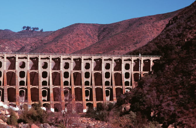
Cracks found in Lake Hodges Dam led to a reinforcement project that was completed by 1937.
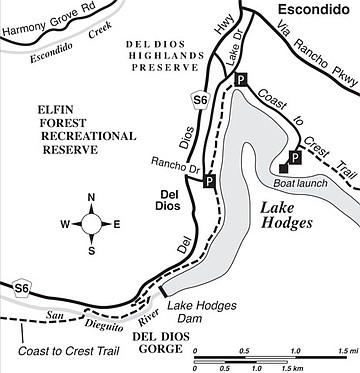
On its roughly 50-mile course from the mountain crest near Julian to the beach at Del Mar, the combined Santa Ysabel Creek/San Dieguito River courses through several steep and narrow canyons. The lowest of these, the Del Dios Gorge, is partly inundated by Lake Hodges, a reservoir whose concrete-arch dam began to impound the waters of the San Dieguito River in 1918. Below that dam today, a steep section of the gorge remains in evidence. A new section of the Coast to Crest Trail, which will one day stretch the entire length of the San Dieguito River and its main tributary, Santa Ysabel Creek, threads its way right down the gorge.
The best time by far to visit Del Dios Gorge is during winter, and better yet if that winter season features above-average rainfall. Every few years, Lake Hodges overflows its spillway, adjacent to the dam, and the resulting spray can create a rainbow, under the right circumstances. Most of the time, because of our dry climate, there’s no dramatic spillage from the reservoir, and water in the gorge slides gently by or gathers in stagnant pools.
The hike into Del Dios Gorge can begin from a trailhead opposite the Hernandez Hideaway Restaurant in the community of Del Dios. To get there from Interstate 15 in Escondido, exit at Via Rancho Parkway, drive west on Via Rancho for 3.5 miles, turn left at the Del Dios Highway traffic light, go 2.0 miles farther to Rancho Drive (traffic light), and turn left again. Rancho Drive goes downhill for 0.3 mile to a San Dieguito River Park trailhead/staging area on the right.
From the trailhead, follow the narrow, beaten-down path that swings right, parallel to the shore of Lake Hodges in the direction of the dam. Some mild ups and downs follow, with frequent views of the water below. At one point, you pass a large, public-works complex on the right. It houses electric pumps and generators that regulate the flow of water between Lake Hodges below and the Olivenhain Reservoir, unseen on the high ridge above.
Nearly two miles into the hike, you reach a point right alongside the nearly century-old, concrete Lake Hodges Dam. Early on, the dam developed troublesome cracks, but by 1937 (following the devastating Long Beach quake of 1933) the dam had been strongly reinforced. Other than some painted-over graffiti, the dam retains its old-world architectural charm.
Just beyond the dam, the trail pulls right alongside Del Dios Highway. Soon, you turn abruptly left and descend toward the bottom of the gorge on an unpaved service road, doubling as the trail route. Notice the remnants of a flume that formerly connected Lake Hodges to a smaller storage reservoir, San Dieguito Reservoir, some four miles away.
As you continue downhill and downstream, there’s never a point where the noise from nearby Del Dios Highway isn’t apparent, but at least you can admire the steeply rising far wall of the gorge and the scattered willows, oaks, and granite outcrops down along the riverbed. Restoration efforts are under way that will ultimately improve the habitat alongside the river. That will encourage the growth of native vegetation and provide better foraging and nesting for birds.
At 3.2 miles from the start, the trail swings sharply left and crosses the San Dieguito River on an elaborate iron footbridge. Further travel on the trail-in-progress ahead will someday allow you to walk all the way out to the beach at Del Mar, but our hike ends here at the bridge. Return the same way you came.
This article contains information about a publicly owned recreation or wilderness area. Trails and pathways are not necessarily marked. Conditions can change rapidly. Hikers should be properly equipped and have safety and navigational skills. The Reader and Jerry Schad assume no responsibility for any adverse experience.
Del Dios Gorge
Explore the Del Dios Gorge at Lake Hodges using a newly opened trail.
Distance from downtown San Diego: 30 miles
Hiking or biking length: 6.4 miles round trip
Difficulty: Moderate
Here's something you might be interested in.
Del Dios Gorge
Del Dios Gorge
Cracks found in Lake Hodges Dam led to a reinforcement project that was completed by 1937.
On its roughly 50-mile course from the mountain crest near Julian to the beach at Del Mar, the combined Santa Ysabel Creek/San Dieguito River courses through several steep and narrow canyons. The lowest of these, the Del Dios Gorge, is partly inundated by Lake Hodges, a reservoir whose concrete-arch dam began to impound the waters of the San Dieguito River in 1918. Below that dam today, a steep section of the gorge remains in evidence. A new section of the Coast to Crest Trail, which will one day stretch the entire length of the San Dieguito River and its main tributary, Santa Ysabel Creek, threads its way right down the gorge.
The best time by far to visit Del Dios Gorge is during winter, and better yet if that winter season features above-average rainfall. Every few years, Lake Hodges overflows its spillway, adjacent to the dam, and the resulting spray can create a rainbow, under the right circumstances. Most of the time, because of our dry climate, there’s no dramatic spillage from the reservoir, and water in the gorge slides gently by or gathers in stagnant pools.
The hike into Del Dios Gorge can begin from a trailhead opposite the Hernandez Hideaway Restaurant in the community of Del Dios. To get there from Interstate 15 in Escondido, exit at Via Rancho Parkway, drive west on Via Rancho for 3.5 miles, turn left at the Del Dios Highway traffic light, go 2.0 miles farther to Rancho Drive (traffic light), and turn left again. Rancho Drive goes downhill for 0.3 mile to a San Dieguito River Park trailhead/staging area on the right.
From the trailhead, follow the narrow, beaten-down path that swings right, parallel to the shore of Lake Hodges in the direction of the dam. Some mild ups and downs follow, with frequent views of the water below. At one point, you pass a large, public-works complex on the right. It houses electric pumps and generators that regulate the flow of water between Lake Hodges below and the Olivenhain Reservoir, unseen on the high ridge above.
Nearly two miles into the hike, you reach a point right alongside the nearly century-old, concrete Lake Hodges Dam. Early on, the dam developed troublesome cracks, but by 1937 (following the devastating Long Beach quake of 1933) the dam had been strongly reinforced. Other than some painted-over graffiti, the dam retains its old-world architectural charm.
Just beyond the dam, the trail pulls right alongside Del Dios Highway. Soon, you turn abruptly left and descend toward the bottom of the gorge on an unpaved service road, doubling as the trail route. Notice the remnants of a flume that formerly connected Lake Hodges to a smaller storage reservoir, San Dieguito Reservoir, some four miles away.
As you continue downhill and downstream, there’s never a point where the noise from nearby Del Dios Highway isn’t apparent, but at least you can admire the steeply rising far wall of the gorge and the scattered willows, oaks, and granite outcrops down along the riverbed. Restoration efforts are under way that will ultimately improve the habitat alongside the river. That will encourage the growth of native vegetation and provide better foraging and nesting for birds.
At 3.2 miles from the start, the trail swings sharply left and crosses the San Dieguito River on an elaborate iron footbridge. Further travel on the trail-in-progress ahead will someday allow you to walk all the way out to the beach at Del Mar, but our hike ends here at the bridge. Return the same way you came.
This article contains information about a publicly owned recreation or wilderness area. Trails and pathways are not necessarily marked. Conditions can change rapidly. Hikers should be properly equipped and have safety and navigational skills. The Reader and Jerry Schad assume no responsibility for any adverse experience.
Del Dios Gorge
Explore the Del Dios Gorge at Lake Hodges using a newly opened trail.
Distance from downtown San Diego: 30 miles
Hiking or biking length: 6.4 miles round trip
Difficulty: Moderate