Here's something you might be interested in.
Ask a Hipster — Advice you didn't know you needed
Big Screen — Movie commentary
Blurt — Music's inside track
Booze News — San Diego spirits
Classical Music — Immortal beauty
Classifieds — Free and easy
Close to Home — What it’s like on the street where you live
Cover Stories — Front-page features
Drinks All Around — Bartenders' drink recipes
Excerpts — Literary and spiritual excerpts
Feast! — Food & drink reviews
Feature Stories — Local news & stories
Fishing Report — What’s getting hooked from ship and shore
From the Archives — Spotlight on the past
Golden Dreams — Talk of the town
The Gonzo Report — Making the musical scene, or at least reporting from it
Letters — Our inbox
Movies@Home — Local movie buffs share favorites
Movie Reviews — Our critics' picks and pans
Musician Interviews — Up close with local artists
Neighborhood News from Stringers — Hyperlocal news
News Ticker — News & politics
Obermeyer — San Diego politics illustrated
Outdoors — Weekly changes in flora and fauna
Overheard in San Diego — Eavesdropping illustrated
Poetry — The old and the new
Reader Travel — Travel section built by travelers
Reading — The hunt for intellectuals
Roam-O-Rama — SoCal's best hiking/biking trails
San Diego Beer — Inside San Diego suds
SD on the QT — Almost factual news
Sheep and Goats — Places of worship
Special Issues — The best of
Street Style — San Diego streets have style
Surf Diego — Real stories from those braving the waves
Theater — On stage in San Diego this week
Tin Fork — Silver spoon alternative
Under the Radar — Matt Potter's undercover work
Unforgettable — Long-ago San Diego
Unreal Estate — San Diego's priciest pads
Your Week — Daily event picks
Mount Zion Loop
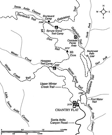
On the Mount Zion loop hike, you get to discover plenty of wild territory tucked back into the steeply rising “Front Range” of the San Gabriel Mountains. Why Front Range? Because these fortress-like ramparts form the mountainous backdrop seen from the San Gabriel Valley and greater Los Angeles Basin.
Get set for a significant effort: 9.4 trail-miles and 2100 feet of elevation gain and loss. Dogs are allowed, and you can stay overnight (if space allows) at either of two trail campgrounds along the way. Contact Angeles National Forest (626-574-5200) to get the latest information about road and trail conditions and other current details.
You’ll start at the ever-popular (parking is sometimes scarce) Chantry Flat trailhead and picnic area above the city of Arcadia. To get there, exit Interstate 210 at Santa Anita Avenue in Arcadia. Drive north through Arcadia and Sierra Madre, pass a vehicle gate (open 6am to 10pm) and continue north on Santa Anita Canyon Road about three miles to reach the parking lots at Chantry Flat. A National Forest Adventure Pass, available onsite, is required.
From the south edge of the lower parking lot at Chantry Flat, hike the first, paved segment of the Gabrielino Trail down to the confluence of Winter Creek and Big Santa Anita Canyon (0.6 mile). Pavement ends at a metal bridge spanning Winter Creek. Pass the restrooms and continue up alder-lined Big Santa Anita Canyon on a wide road bed following the left bank. Edging alongside a number of small cabins, the deteriorating road soon assumes the proportions of a foot trail.
At 1.4 miles, amid a beautiful oak woodland, you come to a four-way junction of trails. The right branch goes up-canyon to Sturtevant Falls; the middle and left branches bypass the falls and join again about a mile upstream. The left, upper trail is recommended for horses. The middle (or lower) trail, for hiking, is more scenic. The lower trail slices across a sheer wall above the falls and continues through a veritable fairyland of miniature cascades and crystalline pools bedecked with giant chain ferns.
A half mile past the reconvergence of the upper and lower trails, you come upon Cascade Picnic Area (2.8 miles), named for a smooth chute in the stream bottom just below. Press on past a crib dam and reach Spruce Grove Trail Camp (3.5 miles), named for the bigcone Douglas-fir (a.k.a. bigcone spruce) trees that attain truly impressive proportions hereabouts.
A little higher and farther, the Gabrielino Trail forks right. You go left on the signed Sturtevant Trail. Go left again, 0.1 mile on, at the entrance to Sturtevant Camp, which is a historic (1893) resort and current Methodist Church retreat. Cross above a crib dam to the opposite side of the creek from the camp, continue another 0.1 mile, and look for stone steps rising on the left — the beginning of the Mount Zion Trail (3.9 miles). You wind upward across a ravine and then along timber-shaded, north-facing slopes.
When you reach the trail crest in a notch just northwest of Mount Zion, take the side path up through manzanita and ceanothus to the summit, where a broad if somewhat unremarkable view can be had of surrounding ridges and a small slice of the San Gabriel Valley.
Return to the main trail and begin a long, switchback descent (1000 feet of elevation loss in about 1.5 miles) down the dry, north canyon wall of Winter Creek. At the foot of this stretch you reach the cool canyon bottom and a T-intersection with the Winter Creek Trail (6.7 miles), lying just above Hoegees Trail Camp. Turn right, going upstream momentarily, follow the trail across the creek, and climb to the next trail junction. Bear left on the Upper Winter Creek Trail and complete the remaining 2.6 miles, cool and semi-shaded most of the way.
This article contains information about a publicly owned recreation or wilderness area. Trails and pathways are not necessarily marked. Conditions can change rapidly. Hikers should be properly equipped and have safety and navigational skills. The Reader and Jerry Schad assume no responsibility for any adverse experience.
Mount Zion Loop
Explore lush canyon spaces on a loop hike through the Angeles National Forest.
Distance from downtown San Diego: 132 miles
Hiking length: 9.4 miles
Difficulty: Strenuous
Here's something you might be interested in.
Mount Zion Loop
Mount Zion Loop
On the Mount Zion loop hike, you get to discover plenty of wild territory tucked back into the steeply rising “Front Range” of the San Gabriel Mountains. Why Front Range? Because these fortress-like ramparts form the mountainous backdrop seen from the San Gabriel Valley and greater Los Angeles Basin.
Get set for a significant effort: 9.4 trail-miles and 2100 feet of elevation gain and loss. Dogs are allowed, and you can stay overnight (if space allows) at either of two trail campgrounds along the way. Contact Angeles National Forest (626-574-5200) to get the latest information about road and trail conditions and other current details.
You’ll start at the ever-popular (parking is sometimes scarce) Chantry Flat trailhead and picnic area above the city of Arcadia. To get there, exit Interstate 210 at Santa Anita Avenue in Arcadia. Drive north through Arcadia and Sierra Madre, pass a vehicle gate (open 6am to 10pm) and continue north on Santa Anita Canyon Road about three miles to reach the parking lots at Chantry Flat. A National Forest Adventure Pass, available onsite, is required.
From the south edge of the lower parking lot at Chantry Flat, hike the first, paved segment of the Gabrielino Trail down to the confluence of Winter Creek and Big Santa Anita Canyon (0.6 mile). Pavement ends at a metal bridge spanning Winter Creek. Pass the restrooms and continue up alder-lined Big Santa Anita Canyon on a wide road bed following the left bank. Edging alongside a number of small cabins, the deteriorating road soon assumes the proportions of a foot trail.
At 1.4 miles, amid a beautiful oak woodland, you come to a four-way junction of trails. The right branch goes up-canyon to Sturtevant Falls; the middle and left branches bypass the falls and join again about a mile upstream. The left, upper trail is recommended for horses. The middle (or lower) trail, for hiking, is more scenic. The lower trail slices across a sheer wall above the falls and continues through a veritable fairyland of miniature cascades and crystalline pools bedecked with giant chain ferns.
A half mile past the reconvergence of the upper and lower trails, you come upon Cascade Picnic Area (2.8 miles), named for a smooth chute in the stream bottom just below. Press on past a crib dam and reach Spruce Grove Trail Camp (3.5 miles), named for the bigcone Douglas-fir (a.k.a. bigcone spruce) trees that attain truly impressive proportions hereabouts.
A little higher and farther, the Gabrielino Trail forks right. You go left on the signed Sturtevant Trail. Go left again, 0.1 mile on, at the entrance to Sturtevant Camp, which is a historic (1893) resort and current Methodist Church retreat. Cross above a crib dam to the opposite side of the creek from the camp, continue another 0.1 mile, and look for stone steps rising on the left — the beginning of the Mount Zion Trail (3.9 miles). You wind upward across a ravine and then along timber-shaded, north-facing slopes.
When you reach the trail crest in a notch just northwest of Mount Zion, take the side path up through manzanita and ceanothus to the summit, where a broad if somewhat unremarkable view can be had of surrounding ridges and a small slice of the San Gabriel Valley.
Return to the main trail and begin a long, switchback descent (1000 feet of elevation loss in about 1.5 miles) down the dry, north canyon wall of Winter Creek. At the foot of this stretch you reach the cool canyon bottom and a T-intersection with the Winter Creek Trail (6.7 miles), lying just above Hoegees Trail Camp. Turn right, going upstream momentarily, follow the trail across the creek, and climb to the next trail junction. Bear left on the Upper Winter Creek Trail and complete the remaining 2.6 miles, cool and semi-shaded most of the way.
This article contains information about a publicly owned recreation or wilderness area. Trails and pathways are not necessarily marked. Conditions can change rapidly. Hikers should be properly equipped and have safety and navigational skills. The Reader and Jerry Schad assume no responsibility for any adverse experience.
Mount Zion Loop
Explore lush canyon spaces on a loop hike through the Angeles National Forest.
Distance from downtown San Diego: 132 miles
Hiking length: 9.4 miles
Difficulty: Strenuous