Here's something you might be interested in.
Ask a Hipster — Advice you didn't know you needed
Big Screen — Movie commentary
Blurt — Music's inside track
Booze News — San Diego spirits
Classical Music — Immortal beauty
Classifieds — Free and easy
Close to Home — What it’s like on the street where you live
Cover Stories — Front-page features
Drinks All Around — Bartenders' drink recipes
Excerpts — Literary and spiritual excerpts
Feast! — Food & drink reviews
Feature Stories — Local news & stories
Fishing Report — What’s getting hooked from ship and shore
From the Archives — Spotlight on the past
Golden Dreams — Talk of the town
The Gonzo Report — Making the musical scene, or at least reporting from it
Letters — Our inbox
Movies@Home — Local movie buffs share favorites
Movie Reviews — Our critics' picks and pans
Musician Interviews — Up close with local artists
Neighborhood News from Stringers — Hyperlocal news
News Ticker — News & politics
Obermeyer — San Diego politics illustrated
Outdoors — Weekly changes in flora and fauna
Overheard in San Diego — Eavesdropping illustrated
Poetry — The old and the new
Reader Travel — Travel section built by travelers
Reading — The hunt for intellectuals
Roam-O-Rama — SoCal's best hiking/biking trails
San Diego Beer — Inside San Diego suds
SD on the QT — Almost factual news
Sheep and Goats — Places of worship
Special Issues — The best of
Street Style — San Diego streets have style
Surf Diego — Real stories from those braving the waves
Theater — On stage in San Diego this week
Tin Fork — Silver spoon alternative
Under the Radar — Matt Potter's undercover work
Unforgettable — Long-ago San Diego
Unreal Estate — San Diego's priciest pads
Your Week — Daily event picks
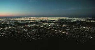
Catch a panoramic view of the L.A. Basin from the historic Mount Wilson Toll Road high above Pasadena.
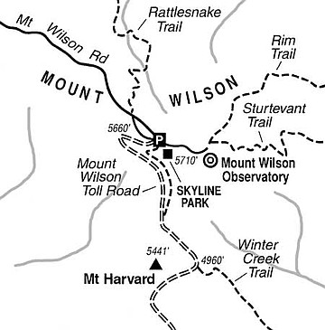
For hikers, the flattish 5700-foot summit of Mount Wilson -- home of the historic (and still viable) Mount Wilson Observatory -- is a jumping-off spot for vintage trails that run downhill in practically every direction. Some trails on the mountain date to as early as 1864.
Perhaps the most famous of the historic trails is the Mount Wilson Toll Road, a mule path used more than a century ago to transport optical equipment to the site of what was, for a time, the world's foremost astronomical observatory. This "toll road" survives today as a fire road closed to cars but open for self-propelled travelers.
The drive to Mount Wilson is an easy one -- after you get to Interstate 210 in the foothill community of La CanadaFlintridge. Take the Angeles Crest Highway north from I-210, climb into the mountains for 13.5 miles, and turn right onto Mount Wilson Road. After another four miles, you'll arrive on the ridgetop of Mount Wilson, where you can park in a large parking area for Skyline Park. Since the entire area lies within Angeles National Forest, you'll need to post a National Forest Adventure Pass on your parked car.
Few tourists who drive up this far for a view of the vast Los Angeles metropolis are aware that a more panoramic vantage point exists a short downhill hike (or mountain-bike ride) away. You get that better view from Mount Harvard, a prominent bump to the south. That peak itself was named in the hope that a Harvard University telescope would be located there. No telescope was ever installed, but a tourist encampment called Martin's Camp was established nearby. A century ago the camp's visitors commonly ascended Harvard Peak to enjoy panoramic views of the largely agricultural flatlands below. Today's view, especially during winter clear-air episodes, takes in hundreds of square miles of urban landscape -- and also hundreds of thousands of city lights if you linger there after sunset.
Start walking or riding from the south edge of the Skyline Park lot. Find and follow either the Mount Wilson Trail (a footpath) or the Mount Wilson Toll Road (the fire road). The latter route offers safer travel at night. At a point 0.7 mile below by way of the trail, or 0.9 mile below by way of the road, you arrive at the Wilson-Harvard saddle, where Martin's Camp stood. Some old foundations, a cluster of Monterey pines, and a concrete shed are there now. Until a few years ago hikers could ascend to Mount Harvard's summit on the original tourist pathway, but alas, telecommunications antennas have appeared on the peak along with formidable razor wire to protect them. Your best bet, then, is to continue about 0.5 mile downhill on the Mount Wilson Toll Road until you reach a spot on the south flank of Mount Harvard where the widest views open up to the south.
This article contains information about a publicly owned recreation or wilderness area. Trails and pathways are not necessarily marked. Conditions can change rapidly. Hikers should be properly equipped and have safety and navigational skills. The Reader and Jerry Schad assume no responsibility for any adverse experience.
Here's something you might be interested in.
Catch a panoramic view of the L.A. Basin from the historic Mount Wilson Toll Road high above Pasadena.
Catch a panoramic view of the L.A. Basin from the historic Mount Wilson Toll Road high above Pasadena.
For hikers, the flattish 5700-foot summit of Mount Wilson -- home of the historic (and still viable) Mount Wilson Observatory -- is a jumping-off spot for vintage trails that run downhill in practically every direction. Some trails on the mountain date to as early as 1864.
Perhaps the most famous of the historic trails is the Mount Wilson Toll Road, a mule path used more than a century ago to transport optical equipment to the site of what was, for a time, the world's foremost astronomical observatory. This "toll road" survives today as a fire road closed to cars but open for self-propelled travelers.
The drive to Mount Wilson is an easy one -- after you get to Interstate 210 in the foothill community of La CanadaFlintridge. Take the Angeles Crest Highway north from I-210, climb into the mountains for 13.5 miles, and turn right onto Mount Wilson Road. After another four miles, you'll arrive on the ridgetop of Mount Wilson, where you can park in a large parking area for Skyline Park. Since the entire area lies within Angeles National Forest, you'll need to post a National Forest Adventure Pass on your parked car.
Few tourists who drive up this far for a view of the vast Los Angeles metropolis are aware that a more panoramic vantage point exists a short downhill hike (or mountain-bike ride) away. You get that better view from Mount Harvard, a prominent bump to the south. That peak itself was named in the hope that a Harvard University telescope would be located there. No telescope was ever installed, but a tourist encampment called Martin's Camp was established nearby. A century ago the camp's visitors commonly ascended Harvard Peak to enjoy panoramic views of the largely agricultural flatlands below. Today's view, especially during winter clear-air episodes, takes in hundreds of square miles of urban landscape -- and also hundreds of thousands of city lights if you linger there after sunset.
Start walking or riding from the south edge of the Skyline Park lot. Find and follow either the Mount Wilson Trail (a footpath) or the Mount Wilson Toll Road (the fire road). The latter route offers safer travel at night. At a point 0.7 mile below by way of the trail, or 0.9 mile below by way of the road, you arrive at the Wilson-Harvard saddle, where Martin's Camp stood. Some old foundations, a cluster of Monterey pines, and a concrete shed are there now. Until a few years ago hikers could ascend to Mount Harvard's summit on the original tourist pathway, but alas, telecommunications antennas have appeared on the peak along with formidable razor wire to protect them. Your best bet, then, is to continue about 0.5 mile downhill on the Mount Wilson Toll Road until you reach a spot on the south flank of Mount Harvard where the widest views open up to the south.
This article contains information about a publicly owned recreation or wilderness area. Trails and pathways are not necessarily marked. Conditions can change rapidly. Hikers should be properly equipped and have safety and navigational skills. The Reader and Jerry Schad assume no responsibility for any adverse experience.