Here's something you might be interested in.
Ask a Hipster — Advice you didn't know you needed
Big Screen — Movie commentary
Blurt — Music's inside track
Booze News — San Diego spirits
Classical Music — Immortal beauty
Classifieds — Free and easy
Close to Home — What it’s like on the street where you live
Cover Stories — Front-page features
Drinks All Around — Bartenders' drink recipes
Excerpts — Literary and spiritual excerpts
Feast! — Food & drink reviews
Feature Stories — Local news & stories
Fishing Report — What’s getting hooked from ship and shore
From the Archives — Spotlight on the past
Golden Dreams — Talk of the town
The Gonzo Report — Making the musical scene, or at least reporting from it
Letters — Our inbox
Movies@Home — Local movie buffs share favorites
Movie Reviews — Our critics' picks and pans
Musician Interviews — Up close with local artists
Neighborhood News from Stringers — Hyperlocal news
News Ticker — News & politics
Obermeyer — San Diego politics illustrated
Outdoors — Weekly changes in flora and fauna
Overheard in San Diego — Eavesdropping illustrated
Poetry — The old and the new
Reader Travel — Travel section built by travelers
Reading — The hunt for intellectuals
Roam-O-Rama — SoCal's best hiking/biking trails
San Diego Beer — Inside San Diego suds
SD on the QT — Almost factual news
Sheep and Goats — Places of worship
Special Issues — The best of
Street Style — San Diego streets have style
Surf Diego — Real stories from those braving the waves
Theater — On stage in San Diego this week
Tin Fork — Silver spoon alternative
Under the Radar — Matt Potter's undercover work
Unforgettable — Long-ago San Diego
Unreal Estate — San Diego's priciest pads
Your Week — Daily event picks
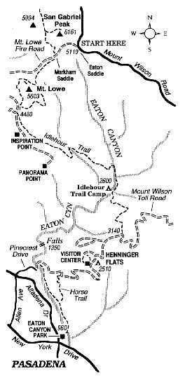
Hike the Idlehour Descent; lose 4000 feet as you trek down the front face of the San Gabriel Mountains toward Pasadena
The "Idlehour Descent" -- not really an idle descent at all -- is a one-way, 11-mile, mostly downhill hike through ever-changing terrain in the San Gabriel Mountains above Altadena and Pasadena. The name "Idlehour" comes from Idlehour Trail Camp, formerly a trail resort, passed at the midway point of the hike.
Have someone drop you off at Eaton Saddle, mile 2.4 on the road to Mount Wilson Observatory (2.4 miles uphill from Angeles Crest Highway). You'll end the hike at Eaton Canyon park, on Altadena Drive just north of New York Drive in Altadena.
From Eaton Saddle, follow the unpaved Mount Lowe Fire Road 0.5 mile west to Markham Saddle, where trails intersect left and right. Bear left on the narrow Mount Lowe Trail. At a trail junction (1.3 miles), the Mt. Lowe west trail comes in acutely from the right. Keep straight to remain on the shorter, better-maintained east-side route down along the flank of the mountain. At 2.1 miles you can either drop to the fire road on your right or stay on the trail another 0.2 mile to meet the same fire road farther south. Continue walking south on the fire road, curving left toward Inspiration Point as the road on the right descends toward Mount Lowe Trail Camp. After another 100 feet, turn left on the Idlehour Trail. You've now come 2.4 miles from the start.
On the narrow trail ahead, you descend through shade-giving groves of live oak and bigcone Douglas-firs. At 3.7 miles you cross a west fork of Eaton Canyon. You then climb a bit to cross a chaparral-covered divide to the east and begin a switchback descent into the main Eaton Canyon. Look for the faultlike discontinuity in the igneous rock exposed on Eaton Canyon's sheer east wall.
At the bottom of the zigzag descent (4.8 miles) the trail stays near the canyon bottom and becomes intermittently lost in a refreshingly cool wonderland of crystal-clear cascades, overarching oaks and maples, and crispy carpets of orange and brown leaf-litter. Cabin foundation ruins can be found under the trees, a reminder that even in this inviting hideaway, no construction is spared for long the ravages of fire and flood. After some easy boulder-hopping, you come to Idlehour Trail Camp (5.4 miles), nestled on an oak-shaded flat lying next to a rock fin, with vertical striations, dividing Eaton Canyon from its aforementioned west fork. This is perhaps the best spot for a picnic lunch.
Below Idlehour Camp, Eaton Canyon abruptly narrows, and its waters tumble over several near-vertical falls, 40 to 50 feet in height, in a three-mile stretch. Don't go that way! Continue on the Idlehour Trail, which ascends the left-side (east) canyon wall, then dives down to a junction with the Mount Wilson Toll Road (6.9 miles). Early in the 20th Century, telescope parts for the Mount Wilson Observatory were laboriously hauled up this road by mule-driven wagons. Today, the old toll road is reserved for self-propelled travelers. Go west, continuing your descent.
At 8.1 miles you reach Henninger Flats, which offers a small visitors' center, planted pines, and potable water. Continue descending to a hairpin turn (9.8 miles), where an equestrian trail takes off down the slope to the left. At the bottom, turn left and complete the remaining short distance to Eaton Canyon's nature center and parking lot.
Here's something you might be interested in.
Hike the Idlehour Descent; lose 4000 feet as you trek down the front face of the San Gabriel Mountains toward Pasadena
Hike the Idlehour Descent; lose 4000 feet as you trek down the front face of the San Gabriel Mountains toward Pasadena
The "Idlehour Descent" -- not really an idle descent at all -- is a one-way, 11-mile, mostly downhill hike through ever-changing terrain in the San Gabriel Mountains above Altadena and Pasadena. The name "Idlehour" comes from Idlehour Trail Camp, formerly a trail resort, passed at the midway point of the hike.
Have someone drop you off at Eaton Saddle, mile 2.4 on the road to Mount Wilson Observatory (2.4 miles uphill from Angeles Crest Highway). You'll end the hike at Eaton Canyon park, on Altadena Drive just north of New York Drive in Altadena.
From Eaton Saddle, follow the unpaved Mount Lowe Fire Road 0.5 mile west to Markham Saddle, where trails intersect left and right. Bear left on the narrow Mount Lowe Trail. At a trail junction (1.3 miles), the Mt. Lowe west trail comes in acutely from the right. Keep straight to remain on the shorter, better-maintained east-side route down along the flank of the mountain. At 2.1 miles you can either drop to the fire road on your right or stay on the trail another 0.2 mile to meet the same fire road farther south. Continue walking south on the fire road, curving left toward Inspiration Point as the road on the right descends toward Mount Lowe Trail Camp. After another 100 feet, turn left on the Idlehour Trail. You've now come 2.4 miles from the start.
On the narrow trail ahead, you descend through shade-giving groves of live oak and bigcone Douglas-firs. At 3.7 miles you cross a west fork of Eaton Canyon. You then climb a bit to cross a chaparral-covered divide to the east and begin a switchback descent into the main Eaton Canyon. Look for the faultlike discontinuity in the igneous rock exposed on Eaton Canyon's sheer east wall.
At the bottom of the zigzag descent (4.8 miles) the trail stays near the canyon bottom and becomes intermittently lost in a refreshingly cool wonderland of crystal-clear cascades, overarching oaks and maples, and crispy carpets of orange and brown leaf-litter. Cabin foundation ruins can be found under the trees, a reminder that even in this inviting hideaway, no construction is spared for long the ravages of fire and flood. After some easy boulder-hopping, you come to Idlehour Trail Camp (5.4 miles), nestled on an oak-shaded flat lying next to a rock fin, with vertical striations, dividing Eaton Canyon from its aforementioned west fork. This is perhaps the best spot for a picnic lunch.
Below Idlehour Camp, Eaton Canyon abruptly narrows, and its waters tumble over several near-vertical falls, 40 to 50 feet in height, in a three-mile stretch. Don't go that way! Continue on the Idlehour Trail, which ascends the left-side (east) canyon wall, then dives down to a junction with the Mount Wilson Toll Road (6.9 miles). Early in the 20th Century, telescope parts for the Mount Wilson Observatory were laboriously hauled up this road by mule-driven wagons. Today, the old toll road is reserved for self-propelled travelers. Go west, continuing your descent.
At 8.1 miles you reach Henninger Flats, which offers a small visitors' center, planted pines, and potable water. Continue descending to a hairpin turn (9.8 miles), where an equestrian trail takes off down the slope to the left. At the bottom, turn left and complete the remaining short distance to Eaton Canyon's nature center and parking lot.