Here's something you might be interested in.
Ask a Hipster — Advice you didn't know you needed
Big Screen — Movie commentary
Blurt — Music's inside track
Booze News — San Diego spirits
Classical Music — Immortal beauty
Classifieds — Free and easy
Close to Home — What it’s like on the street where you live
Cover Stories — Front-page features
Drinks All Around — Bartenders' drink recipes
Excerpts — Literary and spiritual excerpts
Feast! — Food & drink reviews
Feature Stories — Local news & stories
Fishing Report — What’s getting hooked from ship and shore
From the Archives — Spotlight on the past
Golden Dreams — Talk of the town
The Gonzo Report — Making the musical scene, or at least reporting from it
Letters — Our inbox
Movies@Home — Local movie buffs share favorites
Movie Reviews — Our critics' picks and pans
Musician Interviews — Up close with local artists
Neighborhood News from Stringers — Hyperlocal news
News Ticker — News & politics
Obermeyer — San Diego politics illustrated
Outdoors — Weekly changes in flora and fauna
Overheard in San Diego — Eavesdropping illustrated
Poetry — The old and the new
Reader Travel — Travel section built by travelers
Reading — The hunt for intellectuals
Roam-O-Rama — SoCal's best hiking/biking trails
San Diego Beer — Inside San Diego suds
SD on the QT — Almost factual news
Sheep and Goats — Places of worship
Special Issues — The best of
Street Style — San Diego streets have style
Surf Diego — Real stories from those braving the waves
Theater — On stage in San Diego this week
Tin Fork — Silver spoon alternative
Under the Radar — Matt Potter's undercover work
Unforgettable — Long-ago San Diego
Unreal Estate — San Diego's priciest pads
Your Week — Daily event picks
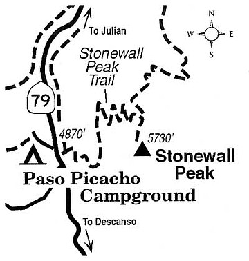
Enjoy unobstructed, post-fire views from Stonewall Peak in Cuyamaca Rancho State Park.
Stonewall Peak's angular summit of white granitic rock is a conspicuous landmark throughout Cuyamaca Rancho State Park. Although Stonewall stands some 800 feet lower than nearby Cuyamaca Peak, its central position and steep, south slope provide a more inclusive view of the park area itself.
Beginning across the highway from the entrance to Paso Picacho Campground (on Highway 79 about midway between Julian and Descanso), the 2.2-mile-long trail to Stonewall's top climbs steadily and moderately on a set of well-graded switchbacks. The former live-oak/black-oak forest and scattered pines and cedars that grew on the mountain's lower slopes prior to the 2003 Cedar Fire are mostly gone now. Pioneering shrubbery is making a comeback, but there's not yet enough of it to seriously block the view -- which expands incrementally the higher you go.
About halfway up the trail, a view opens to the north and east. Cuyamaca Reservoir lies to the north, its level and its extent varying according to the season and the year's precipitation. During the wettest years, the water surface floods a spacious meadow just above the main reservoir and covers a total of nearly 1000 acres.
When you reach the top of the switchback segments, turn right (south) toward the summit of the peak. Follow the trail as it knifes upward to the ridge top and farther to the base of the Stonewall's naked granite summit. A series of steps hewn in the rock and a guardrail are provided in the last, very steep hundred feet or so. The Stonewall hike is a great one for kids, but very small ones must be carefully guarded on the final climb up the steps.
On top, you won't see any ocean views (the main Cuyamaca Mountains ridgeline stands tall in the west), but the foreground panorama of the park's rolling topography is impressive enough. Late-season precipitation (the peak was dusted with snow as late as April 5) will ensure that the landscape below remains emerald-green for a few more weeks to come.
During spring and summer, swallows or swifts practically rake the summit during their high-speed maneuvers, and larger birds -- ravens, hawks, and even bald eagles -- may cruise by. Eagles, along with egrets, herons, and ospreys, are attracted to the shoreline of nearby Cuyamaca Reservoir, especially in winter.
This article contains information about a publicly owned recreation or wilderness area. Trails and pathways are not necessarily marked. Conditions can change rapidly. Hikers should be properly equipped and have safety and navigational skills. The Reader and Jerry Schad assume no responsibility for any adverse experience.
Here's something you might be interested in.
Enjoy unobstructed, post-fire views from Stonewall Peak in Cuyamaca Rancho State Park.
Enjoy unobstructed, post-fire views from Stonewall Peak in Cuyamaca Rancho State Park.
Stonewall Peak's angular summit of white granitic rock is a conspicuous landmark throughout Cuyamaca Rancho State Park. Although Stonewall stands some 800 feet lower than nearby Cuyamaca Peak, its central position and steep, south slope provide a more inclusive view of the park area itself.
Beginning across the highway from the entrance to Paso Picacho Campground (on Highway 79 about midway between Julian and Descanso), the 2.2-mile-long trail to Stonewall's top climbs steadily and moderately on a set of well-graded switchbacks. The former live-oak/black-oak forest and scattered pines and cedars that grew on the mountain's lower slopes prior to the 2003 Cedar Fire are mostly gone now. Pioneering shrubbery is making a comeback, but there's not yet enough of it to seriously block the view -- which expands incrementally the higher you go.
About halfway up the trail, a view opens to the north and east. Cuyamaca Reservoir lies to the north, its level and its extent varying according to the season and the year's precipitation. During the wettest years, the water surface floods a spacious meadow just above the main reservoir and covers a total of nearly 1000 acres.
When you reach the top of the switchback segments, turn right (south) toward the summit of the peak. Follow the trail as it knifes upward to the ridge top and farther to the base of the Stonewall's naked granite summit. A series of steps hewn in the rock and a guardrail are provided in the last, very steep hundred feet or so. The Stonewall hike is a great one for kids, but very small ones must be carefully guarded on the final climb up the steps.
On top, you won't see any ocean views (the main Cuyamaca Mountains ridgeline stands tall in the west), but the foreground panorama of the park's rolling topography is impressive enough. Late-season precipitation (the peak was dusted with snow as late as April 5) will ensure that the landscape below remains emerald-green for a few more weeks to come.
During spring and summer, swallows or swifts practically rake the summit during their high-speed maneuvers, and larger birds -- ravens, hawks, and even bald eagles -- may cruise by. Eagles, along with egrets, herons, and ospreys, are attracted to the shoreline of nearby Cuyamaca Reservoir, especially in winter.
This article contains information about a publicly owned recreation or wilderness area. Trails and pathways are not necessarily marked. Conditions can change rapidly. Hikers should be properly equipped and have safety and navigational skills. The Reader and Jerry Schad assume no responsibility for any adverse experience.