Here's something you might be interested in.
Ask a Hipster — Advice you didn't know you needed
Big Screen — Movie commentary
Blurt — Music's inside track
Booze News — San Diego spirits
Classical Music — Immortal beauty
Classifieds — Free and easy
Close to Home — What it’s like on the street where you live
Cover Stories — Front-page features
Drinks All Around — Bartenders' drink recipes
Excerpts — Literary and spiritual excerpts
Feast! — Food & drink reviews
Feature Stories — Local news & stories
Fishing Report — What’s getting hooked from ship and shore
From the Archives — Spotlight on the past
Golden Dreams — Talk of the town
The Gonzo Report — Making the musical scene, or at least reporting from it
Letters — Our inbox
Movies@Home — Local movie buffs share favorites
Movie Reviews — Our critics' picks and pans
Musician Interviews — Up close with local artists
Neighborhood News from Stringers — Hyperlocal news
News Ticker — News & politics
Obermeyer — San Diego politics illustrated
Outdoors — Weekly changes in flora and fauna
Overheard in San Diego — Eavesdropping illustrated
Poetry — The old and the new
Reader Travel — Travel section built by travelers
Reading — The hunt for intellectuals
Roam-O-Rama — SoCal's best hiking/biking trails
San Diego Beer — Inside San Diego suds
SD on the QT — Almost factual news
Sheep and Goats — Places of worship
Special Issues — The best of
Street Style — San Diego streets have style
Surf Diego — Real stories from those braving the waves
Theater — On stage in San Diego this week
Tin Fork — Silver spoon alternative
Under the Radar — Matt Potter's undercover work
Unforgettable — Long-ago San Diego
Unreal Estate — San Diego's priciest pads
Your Week — Daily event picks
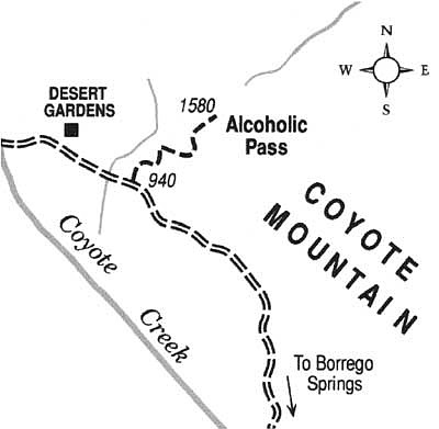
Savor the view from lofty Alcoholic Pass in the Anza-Borrego Desert
Centuries-old paths, forged by the footsteps of Native-Americans, crisscross the county. West of the desert, periodic fires and fast-growing chaparral have erased the obvious traces of most of these trails. Yet in the drier, more austere sections of the Anza-Borrego Desert, traces of Indian trails abound. It's not very difficult to locate them: Just put yourself in the shoes -- or rather agave-fiber sandals -- of a desert-dwelling Native-American in prehistoric times. Imagine how you would navigate from one valley or basin to another, over terrain bristling with cholla cactus and strewn with jagged rock. You'll very quickly be searching out the most expeditious, and least painful, route to your destination. Your choice may well coincide with a prehistoric pathway.
One such pathway penetrates a low spot -- now known as Alcoholic Pass -- in the long, undulating ridge of Coyote Mountain. The mountain, squeezed between two parallel geologic faults, stands like a barrier between the broad, open mouth of Coyote Canyon, north of Borrego Springs, and the even broader expanse of Clark Valley to the east. Around the turn of the century, the Clark brothers, early cattlemen who homesteaded in Coyote Canyon, used this trail to transport some primitive well-drilling equipment to the site now known as Clark Well in Clark Valley. Near the top of the pass, the old Indian trail squeezed between two boulders so closely spaced that the burros had to be unpacked before going through.
The starting point for a hike up the old Alcoholic Pass trail can be found along the main Coyote Canyon dirt road, 2.5 miles north of the end of the pavement on DiGiorgio Road in Borrego Springs. A small sign indicates the start of the trail. Park in one of the roadside turnouts nearby. Look east to spy a steep ravine leading up toward the pass. The old Indian trail does not ascend this ravine directly but instead rises on the ridge immediately south of it. You'll find the base of the trail about 150 yards to the right (south) of the mouth of the ravine.
Once you're on the somewhat rough and rocky path, you gain altitude quickly. In a few spots, foot travel and erosion have worn the bed of the trail to a depth of two feet. The ever-widening, almost aerial, view of Coyote Canyon and the surrounding mountains behind you is impressive.
Head for the pile of boulders at the top of the pass. There you'll catch sight of the massive wall of the Santa Rosa Mountains, east across Clark Valley. You've traveled just one mile from your car and gained some 650 feet of elevation. The remainder of the old Alcoholic Pass route goes east down along a sandy slope and eventually reaches Clark Valley's desolate floor.
Here's something you might be interested in.
Savor the view from lofty Alcoholic Pass in the Anza-Borrego Desert
Savor the view from lofty Alcoholic Pass in the Anza-Borrego Desert
Centuries-old paths, forged by the footsteps of Native-Americans, crisscross the county. West of the desert, periodic fires and fast-growing chaparral have erased the obvious traces of most of these trails. Yet in the drier, more austere sections of the Anza-Borrego Desert, traces of Indian trails abound. It's not very difficult to locate them: Just put yourself in the shoes -- or rather agave-fiber sandals -- of a desert-dwelling Native-American in prehistoric times. Imagine how you would navigate from one valley or basin to another, over terrain bristling with cholla cactus and strewn with jagged rock. You'll very quickly be searching out the most expeditious, and least painful, route to your destination. Your choice may well coincide with a prehistoric pathway.
One such pathway penetrates a low spot -- now known as Alcoholic Pass -- in the long, undulating ridge of Coyote Mountain. The mountain, squeezed between two parallel geologic faults, stands like a barrier between the broad, open mouth of Coyote Canyon, north of Borrego Springs, and the even broader expanse of Clark Valley to the east. Around the turn of the century, the Clark brothers, early cattlemen who homesteaded in Coyote Canyon, used this trail to transport some primitive well-drilling equipment to the site now known as Clark Well in Clark Valley. Near the top of the pass, the old Indian trail squeezed between two boulders so closely spaced that the burros had to be unpacked before going through.
The starting point for a hike up the old Alcoholic Pass trail can be found along the main Coyote Canyon dirt road, 2.5 miles north of the end of the pavement on DiGiorgio Road in Borrego Springs. A small sign indicates the start of the trail. Park in one of the roadside turnouts nearby. Look east to spy a steep ravine leading up toward the pass. The old Indian trail does not ascend this ravine directly but instead rises on the ridge immediately south of it. You'll find the base of the trail about 150 yards to the right (south) of the mouth of the ravine.
Once you're on the somewhat rough and rocky path, you gain altitude quickly. In a few spots, foot travel and erosion have worn the bed of the trail to a depth of two feet. The ever-widening, almost aerial, view of Coyote Canyon and the surrounding mountains behind you is impressive.
Head for the pile of boulders at the top of the pass. There you'll catch sight of the massive wall of the Santa Rosa Mountains, east across Clark Valley. You've traveled just one mile from your car and gained some 650 feet of elevation. The remainder of the old Alcoholic Pass route goes east down along a sandy slope and eventually reaches Clark Valley's desolate floor.