Here's something you might be interested in.
Ask a Hipster — Advice you didn't know you needed
Big Screen — Movie commentary
Blurt — Music's inside track
Booze News — San Diego spirits
Classical Music — Immortal beauty
Classifieds — Free and easy
Close to Home — What it’s like on the street where you live
Cover Stories — Front-page features
Drinks All Around — Bartenders' drink recipes
Excerpts — Literary and spiritual excerpts
Feast! — Food & drink reviews
Feature Stories — Local news & stories
Fishing Report — What’s getting hooked from ship and shore
From the Archives — Spotlight on the past
Golden Dreams — Talk of the town
The Gonzo Report — Making the musical scene, or at least reporting from it
Letters — Our inbox
Movies@Home — Local movie buffs share favorites
Movie Reviews — Our critics' picks and pans
Musician Interviews — Up close with local artists
Neighborhood News from Stringers — Hyperlocal news
News Ticker — News & politics
Obermeyer — San Diego politics illustrated
Outdoors — Weekly changes in flora and fauna
Overheard in San Diego — Eavesdropping illustrated
Poetry — The old and the new
Reader Travel — Travel section built by travelers
Reading — The hunt for intellectuals
Roam-O-Rama — SoCal's best hiking/biking trails
San Diego Beer — Inside San Diego suds
SD on the QT — Almost factual news
Sheep and Goats — Places of worship
Special Issues — The best of
Street Style — San Diego streets have style
Surf Diego — Real stories from those braving the waves
Theater — On stage in San Diego this week
Tin Fork — Silver spoon alternative
Under the Radar — Matt Potter's undercover work
Unforgettable — Long-ago San Diego
Unreal Estate — San Diego's priciest pads
Your Week — Daily event picks
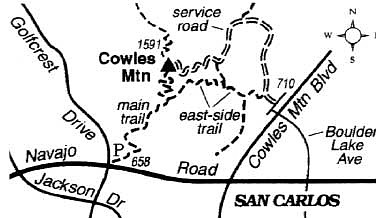
Climb Cowles Mountain, highest peak in the city of San Diego, by way of an eastern approach.
Cowles Mountain, whose 1591-foot summit is noted as the highest elevation in the city of San Diego, is served by more hiking routes than most people are aware of. If you tire of the popular main trail up the mountain's south side -- used by perhaps 90 percent of all Cowles climbers -- then give this looping east-side route a try instead.
Midday ascents can turn out to be colorless and sweaty, particularly on hot days. Favor instead the late afternoon, when the mountain itself casts a cool shadow on its east flank, or better yet the early morning, when (with increasing frequency as autumn approaches) a strong temperature inversion traps chilled air below the mountain's mid-elevations, producing a dense blanket of cloud or fog over the city below. On some early mornings, when the marine-layer fog lies dense and low over the slumbering city, the clear, dry air at the summit may be 15 degrees warmer than the soupy air below.
Begin on Barker Way, very near the west terminus of Boulder Lake Avenue, one block west of Cowles Mountain Boulevard. Squeeze past the vehicle gate and start climbing up the service road. Footwear with good traction will help on the sometimes steep and slippery, hard-packed dirt roadway. Two level stretches relieve the uphill grind, then six short, very steep switchback legs lead to the summit.
Two large interpretive panels on the summit, depicting foreground and background geographical features, may enlighten you -- especially if you are not familiar with the San Diego/northern Baja region. The view is unobstructed from here, except for a blocky antenna tower to the north.
Return to your starting point by descending the upper 0.5 mile of the main, south trail. Then veer left (east) on the lesser-traveled east trail, where a sign says Barker Way. In the next (and final) mile, you bend northeast around the mountain and descend on tight zigzags. Near the bottom, don't miss the final, sharp turn to the left (going straight puts you on another trail, without switchbacks, heading south). You end up back on the service road, close to where it meets Barker Way.
Here's something you might be interested in.
Climb Cowles Mountain, highest peak in the city of San Diego, by way of an eastern approach.
Climb Cowles Mountain, highest peak in the city of San Diego, by way of an eastern approach.
Cowles Mountain, whose 1591-foot summit is noted as the highest elevation in the city of San Diego, is served by more hiking routes than most people are aware of. If you tire of the popular main trail up the mountain's south side -- used by perhaps 90 percent of all Cowles climbers -- then give this looping east-side route a try instead.
Midday ascents can turn out to be colorless and sweaty, particularly on hot days. Favor instead the late afternoon, when the mountain itself casts a cool shadow on its east flank, or better yet the early morning, when (with increasing frequency as autumn approaches) a strong temperature inversion traps chilled air below the mountain's mid-elevations, producing a dense blanket of cloud or fog over the city below. On some early mornings, when the marine-layer fog lies dense and low over the slumbering city, the clear, dry air at the summit may be 15 degrees warmer than the soupy air below.
Begin on Barker Way, very near the west terminus of Boulder Lake Avenue, one block west of Cowles Mountain Boulevard. Squeeze past the vehicle gate and start climbing up the service road. Footwear with good traction will help on the sometimes steep and slippery, hard-packed dirt roadway. Two level stretches relieve the uphill grind, then six short, very steep switchback legs lead to the summit.
Two large interpretive panels on the summit, depicting foreground and background geographical features, may enlighten you -- especially if you are not familiar with the San Diego/northern Baja region. The view is unobstructed from here, except for a blocky antenna tower to the north.
Return to your starting point by descending the upper 0.5 mile of the main, south trail. Then veer left (east) on the lesser-traveled east trail, where a sign says Barker Way. In the next (and final) mile, you bend northeast around the mountain and descend on tight zigzags. Near the bottom, don't miss the final, sharp turn to the left (going straight puts you on another trail, without switchbacks, heading south). You end up back on the service road, close to where it meets Barker Way.