Here's something you might be interested in.
Ask a Hipster — Advice you didn't know you needed
Big Screen — Movie commentary
Blurt — Music's inside track
Booze News — San Diego spirits
Classical Music — Immortal beauty
Classifieds — Free and easy
Close to Home — What it’s like on the street where you live
Cover Stories — Front-page features
Drinks All Around — Bartenders' drink recipes
Excerpts — Literary and spiritual excerpts
Feast! — Food & drink reviews
Feature Stories — Local news & stories
Fishing Report — What’s getting hooked from ship and shore
From the Archives — Spotlight on the past
Golden Dreams — Talk of the town
The Gonzo Report — Making the musical scene, or at least reporting from it
Letters — Our inbox
Movies@Home — Local movie buffs share favorites
Movie Reviews — Our critics' picks and pans
Musician Interviews — Up close with local artists
Neighborhood News from Stringers — Hyperlocal news
News Ticker — News & politics
Obermeyer — San Diego politics illustrated
Outdoors — Weekly changes in flora and fauna
Overheard in San Diego — Eavesdropping illustrated
Poetry — The old and the new
Reader Travel — Travel section built by travelers
Reading — The hunt for intellectuals
Roam-O-Rama — SoCal's best hiking/biking trails
San Diego Beer — Inside San Diego suds
SD on the QT — Almost factual news
Sheep and Goats — Places of worship
Special Issues — The best of
Street Style — San Diego streets have style
Surf Diego — Real stories from those braving the waves
Theater — On stage in San Diego this week
Tin Fork — Silver spoon alternative
Under the Radar — Matt Potter's undercover work
Unforgettable — Long-ago San Diego
Unreal Estate — San Diego's priciest pads
Your Week — Daily event picks
How San Diego lost its pueblo land
Property, power and greed
Lot 1304. We will soon be asked to give away Pueblo Lot 1304. Judging from recent history, we will probably say yes.
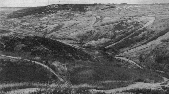
Out in the sprawling north of this city is a mesa that rises just south of La Jolla Village Drive, a mile or so west of Interstate 805. To get there you have to walk through dry grasses with wheat-like seed stalks that break off and stick in your socks, hop across vertically walled, deep runoff scars that plunge down ravines to sycamores on a creek bed.
Lot 1303. The mayor’s was one of six council votes that granted Summers’ request to change his 123 acres on Pueblo Lot 1303 from single-family to multiple-family zoning.
As you climb to the mesa the most evident signs of life are droppings — either the perfect super-BBs of the rabbits or the furry leavings of the coyotes that ate the rabbits. Chaparral, some of it burned, leaves black carbon streaks on your clothes. It’s this city’s typical undeveloped land: dry, rocky, and unshaded.
Fitch’s 1843 boundary line started at the southern tip of Point Loma and ran eastward into the Chollas Valley, then north some twenty-seven miles to its point of intersection with the sea at Carmel Valley (or Penasquitos lagoon), then south along the coast back to Point Loma.
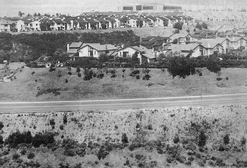
Now, if you stand at a particular point on that mesa, and if you draw a line in the dirt from north to south and then straddle that line, you will have one foot on Pueblo Lot 1303 and the other on Pueblo Lot 1304 — one foot in San Diego’s future and the other in its past. The foot on Pueblo Lot 1303 is just inside the boundary of Harry L. Summers’ 121 acres, which he is going to fill with a ten-acre manmade lake ringed by 2500 condominiums. The other foot, the more easterly on Pueblo Lot 1304, is resting on land you and I own along with everybody else who lives inside the city limits — pueblo land.
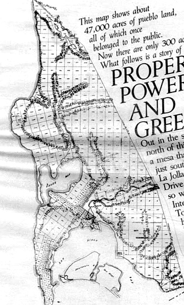
The city proposed selling pueblo land (seen here) to Irvin Kahn to develop what would become University City.
Voters voted the idea down in 1961 and 1963.
This is not properly called city-owned land; it is land given us by the kings of Spain and held in trust for us by the city’s government. It is vacant and undeveloped — lot 1304 is virginal, really — because you and I have never voted to sell it. In the 1850s, there were more than 40,000 acres of this communal land in San Diego. Now there are something like 300 acres left, and most of these are here on Pueblo Lot 1304, next door to Harry Summers and within eyesight of University Towne Centre. We you and I — are probably not going to own Pueblo Lot 1304 much longer.
Much of the land . . . held by titles at least very doubtful, if not entirely fraudulent, has been divided up and sold to speculators who will endeavor to dispose of it to the new settlers at exorbitant profits.
So wrote Colonel R.P. Mason in an 1849 letter to Brigadier General R. Jones of California’s provisional government. Mason was commenting on a report on land sales in San Diego immediately after Mexico’s loss of California to the United States. His observations, distressingly applicable even today, were made just sixteen years after settlers here had gathered together in sufficient numbers to make a credible request of the recently established Mexican government for status as a pueblo, to form their own municipality.
When that request was granted in 1834, there remained to be resolved the question of how much land belonged to the pueblo, and exactly where that land ended and where there began the independent, private ranchos held by the backcountry dons. Eleven years passed before the local government finally ordered its Anglo legal counsel, Henry D. Fitch, a one-time sea captain whose map-reading skills were evidently believed to qualify him for the task of map making, to go out into the countryside, stake the pueblo’s claims, and then draw a map of those claims.
Fitch used the opportunity to expand greatly upon the boundaries originally (though not precisely) defined by King Charles IV of Spain in 1791. The crown had been eager to secure its new territory by encouraging settlement, and had declared this far-flung outpost of the Spanish empire to be a legitimate pueblo, a civil unit. The local pioneers were granted four square leagues (roughly seventy square miles) of land, to be divided up for various uses — common areas, government property, private development, and so on.
By the time Fitch was done with his mapping, however, the pueblo’s area had increased to eleven square leagues. Fitch’s boundary line started at the southern tip of Point Loma and ran eastward into the Chollas Valley, then north some twenty-seven miles to its point of intersection with the sea at Carmel Valley (or Penasquitos lagoon), then south along the coast back to Point Loma. The generally triangular shape of the area delineated by Fitch was presented in map form to Mexican Governor Pio Pico, who signed his approval early in 1846.
The transfer of authority in 1821 from the Spanish to the Mexican regimes had been relatively uneventful, and in the several decades of the Mexican period, government officials here went about their business of dealing out small plots to settlers and maintaining common areas for grazing and municipally owned tracts. When the American Navy landed at Monterey in 1846 and planted the stars and stripes there, the new military government of the United States did exactly what the Mexicans had done when they took over California from the Spanish king; it declared that all laws and property transactions of the previous regime would be honored under U.S. rule.
The U.S. Lands Commission was created to authenticate the titles of landholders and the extent of municipal bounds of the former pueblos, and in 1852 determined that “the president and the trustees of San Diego succeeded to all the claims of the former Mexican pueblo." The major exhibit was the Fitch map. (Los Angeles was not so lucky. That pueblo had never gotten around to drawing a map of its boundaries, and L.A. citizens have never been able to claim rights to pueblo lands.) A few years after the lands commission decision, a California Supreme Court ruling established that these lands were not absolutely owned by the municipalities “with full rights of disposition and alienation, but to be held by them in trust for the benefit of the entire community," thus continuing the chain of public trust passed first by the Spanish king to the pioneering residents and down to the municipal governments of American San Diego.
Either because the Mexican government and the Spanish before it did not intensely recruit settlers, or because the prospect of a grant of land was not accompanied by some additional lure — a gold strike or coal find — a population boom in pre-statehood San Diego did not occur. In fact, there is evidence that suggests many of those who came here in the middle of the Nineteenth Century sniffed the winds, took in only dust and fleas, and decided to remove themselves. In 1838 the population of the newly formed (and vast) Mexican pueblo sank below the required 500 minimum, and the official incorporation was repealed. Years later, just after California became U.S. property in 1850, San Diego as a city again lost its incorporation, and again a drop in the population was to blame. The new state legislature, in yanking away San Diego’s status as a city, took the precautionary measure of protecting the public’s pueblo land — it forbade the town’s trustees from selling any of the land unless it was to cancel old municipal debts. Local officials, however, ignored the law. E. W. Morse, one of those lucky buyers who later became a town trustee himself, managed in 1853 to convince the trustees to sell him 302 subdivided lots on pueblo land in Old Town for seventy-six dollars, or twenty-five and a half cents per lot. In a burst of sheer nerve, a trustee later sold himself more than ninety acres of pueblo land at a price he was careful not to allow disclosed in the board’s minutes. According to Harry Hopkins, a former deputy city attorney who in 1928 wrote a little-known history of the pueblo lands, "It looks very much as though the board met, each member took what he wanted, and let it go at that.” By the time E.W. Morse took his turn as a trustee in the mid-1860s, San Diego’s city center was still Old Town’s dusty plaza, the same one that Diane Powers in this century was to convert to a green gateway to her Bazaar del Mundo. But Alonzo Horton came to town in 1867, and he and Morse combined in a move that was to establish the city center at its present location, on the swampy edges of the little-used but deep and expansive harbor to the south. Morse and one of the other two trustees signed a deed granting 960 waterfront acres of pueblo land to Horton at the price of twenty-seven and a half cents per acre, only pennies more than Morse had paid for his land fourteen years earlier. According to Hopkins, and an earlier 1926 article in the San Diego Union by historian Daniel Cleveland, Horton turned over forty of those downtown acres to city father Morse the day after Morse and the other trustee signed the deed for the 960 acres.
Of course, land was cheaper in those days than it is now, but Horton, Morse, and others who shared in the spoils of early government were clearly getting deals of astounding value. When the land was auctioned publicly, it sold for far higher prices, and even then was probably auctioned only in amounts needed to pay the town’s bills. The same year Morse bought his 302 Old Town lots for seventy-six dollars, someone else was buying at auction 236 lots in the same Old Town area for a per-lot price forty times higher than that paid by Morse. Perhaps the biggest attempted giveaway came in April of 1870, when trustee Matthew Sherman and another trustee named Estudillo combined in a majority to vote an outright grant of 5000 acres — easily one-eighth of the remaining pueblo land, and probably more — to the San Diego and Los Angeles Railway Company in one of the many attempts to establish San Diego as a rail nexus. A year later the lone trustee who had not approved the grant joined with two new trustees in filing a legal action against that railroad grant. The grounds? Matthew Sherman was both a stockholder and officer of the railway company. The state supreme court declared the land transfer null and void.
By 1871, 13,000 acres of the original 47,000 acres mapped out by Fitch “had been given or sold to nonresidents, or to relatives or favorites of the city trustees,” historian Cleveland wrote almost fifty years ago, citing a Union article of 1871. He estimated that the city bought back various parcels, for civic uses, at a cost five times greater than the total collected in sales of the pueblo lots. The rapid trading away of communal land at discount rates had so alarmed the state legislature, according to Deputy City Attorney Hopkins, that a bill was passed in 1872 demanding that all the state’s cities sell pueblo land only at public auction rather than through the private negotiations that had been nearly standard procedure following statehood.
Whether or not the state did actually attempt to force the cities to auction the land when it was sold after 1872, the law was either ignored or it was already too late to do any good. By 1890, fully eighty-three percent of San Diego’s pueblo lands were in private hands; only about 8000 acres remained. A more enlightened citizenry at the turn of the century began awakening, after some prodding by influential leaders and the state legislature, to the reality of what had been lost. Some of the most scenic areas of pueblo lands, those at the northernmost end of Torrey Pines Mesa, were being leased in 1890 by the city council to sheep and cattle grazers whose campfires by design were claiming the mesa’s trees for fuel, or by accident when the fires spread. An influential George W. Marston (who later gave the city Presidio Park) persuaded other community leaders to encourage public support for a park on the mesa, and at the turn of the century the council was moved to set aside 369 acres (Pueblo Lots 1332, 1333, 1336, and 1337) to be “forever held in trust by the municipal authorities as a free and public park.” The more northerly stand of trees on the pueblo lots at the very border of the city’s limits (Pueblo Lots 1338 and 1339) had been sold in the 1870s to a man who was about to begin development there. Ellen Browning Scripps stepped in and from 1900 to 1904 managed to acquire those additional acres of trees. The Marston initiative and Scripps’s acquisitions formed the nucleus of the existing Torrey Pines State Preserve.
While those rescue operations were underway, laws were being drawn. An amendment to the city charter voted by the people in 1889 accomplished what the state had failed to do in 1872: no pueblo lands thereafter could be sold outside of public auction. The state legislature a year later slapped a thirty-year moratorium on the sale or lease of any pueblo lands, thus usurping the council’s prerogatives altogether. A charter amendment passed by the electorate in 1909 raised the prohibition further, extending to 1930 the ban against sales and compelling the council after the expiration of the moratorium to seek voter ratification of any sales of land north of the San Diego River (presumably because virtually all the land south of Mission Valley was already in private hands or had been repurchased by the city for public buildings). A 1931 city charter amendment replacing that 1909 section said virtually the same thing, but added that the council could lease pueblo lands for terms no longer than fifteen years. Neither of these laws, however, restricted the city to auctioned sales only; private negotiations could still take place, an accidental or purposeful omission that years later would lead to alleged abuses of the public trust. But the reforming zeal had fashioned some very stringent law, law which still binds the council and city officials today — at least theoretically.
- It is a shame that, despite the lip service given the pueblo land concept by Nineteenth Century American administrators, our California pueblo lands were squandered away by generations of unthinking municipal officials. — City Attorney John Witt, 1977
How this city went from a communal holding of some 8000 acres of pueblo lands in 1890 to today’s paltry 300 acres is a disheartening story, though one somewhat more free of official greed and venality than that of the notoriously individualistic Nineteenth Century.
Much as it did in 1979, the Navy in 1919 took a look at Balboa Park and saw a hospital there. The city gave up seventeen acres of pueblo land on the high ground that year and belatedly asked the voters for approval in 1920 (though nothing in the charter demanded it do so, since the park was south of Mission Valley). The Navy’s special status also won for it pueblo tidelands for t|ie Naval Training Center on Point Loma, a refueling station, and the area around the foot of Broadway. From 1920 through 1941, more land in Balboa Park was taken to expand the hospital, on four different occasions. Also in the same period, after the moratorium expired north of the river in 1930, pueblo lands near what is now Miramar went for rifle ranges, more tidelands went for repair stations, a National Guard armory, and for what is now the Coast Guard air station on Harbor Drive — all of those grants being approved by a patriotic electorate.
Also in this period and after World War II, Collier Park in Ocean Beach began disappearing, portions of it in 1937 for a school and construction of a street, more of it for streets in 1951 and still more of it in 1953 for a home for unwed mothers, all approved by the electorate, though the charter did not demand the city seek the vote. (The park is now gone altogether.) In 1948 conveyance of Torrey Pines Park to the state, which did require a vote, was accomplished on the ballot. The homebuilders were moving in now, and various pueblo lots (most of which measured just under one square mile) were being mapped and subdivided, and sewers and water lines were dug in preparation for development. Much of the lush La Jolla Shores Drive area was being sold by the city in 1951, for example. In one case, the city hired an appraiser who came in with an estimate that the twenty acres of Pueblo Lot 1297, just east of La Jolla Shores Drive between Camino del Corta and Camino del Collado, were worth $2000 an acre. At an auction in the property manager’s offices on November 21, 1951, Richard Gill and Arthur A. Seeligson, the sole bidders, paid exactly the minimum bid set by the appraisal — $40,000 for the twenty acres. But the cost to the city for improving the lots and readying them for the sale was nearly the same as or even more than the sale price. On nearby Pueblo Lot 1299, for example, thecity was spending $2450 per residential lot to install sewers, water lines, and cut streets.
Five years after the two lone bidders won the La Jolla Shores acreage, General Atomic was able to pick up similarly desirable property on Torrey Pines Mesa for its huge lab, the first onto the mesa of a now-familiar wall of high-tech palaces. General Atomic fared even better than the developers at the shores — its 320 acres of pueblo land came from the city free of charge. (The same year General Atomic received its gift, somebody elsewhere in the city was buying forty-five acres of pueblo land at a per-acre price at $4278. Another auction in 1958 of sixty-five acres brought a per-acre price of $6350.)
Enter now the 1960s. the era when most of us became aware that land was scarce and growing scarcer, even here in sleepy San Diego. There was afoot in city hall a notion to divest the city (its citizens, really) of all the remaining 2100 acres of pueblo lands that had not at that point been subjected to a public referendum. It was a quixotic move, considering that the voters were getting a bit suspicious of their elected representatives. In 1961 an attempt to sell more pueblo land was defeated at the polls. Two years later the council and its manager, Walter Hahn, were careful to explain the matter more fully. Most of the 2000-odd acres proposed for sale in 1963 would go to Irvin Kahn’s University City Corporation to develop the area that now bears his company’s name. Kahn had holdings all over the city’s north, but they weren’t contiguous; what he and the city’s elected and unelected officials wanted to do was trade away the unbroken, large pueblo lots to him for the smaller slivers and scraps that Kahn had collected. In addition, Kahn was going to buy outright some of the acreage. The city told voters that the Kahn properties it wanted to exchange for the pueblo lots would be used for park and school sites. A sharp-eyed citizen raised the embarrassing question of how the city would “earmark" those pueblo acres to Irvin Kahn when manager Hahn was also saying publicly that “all sales will be through public auction.” A week or so before the vote was scheduled, Hahn attempted to explain that Kahn would “probably” be the highest bidder because he could develop the land at less expense than anyone else. The proposition went down to defeat in November, 1963.
Wiser, but no less committed to the University City idea, the council and its manager months later dragged the Kahn package out of the ashes, this time in a confusing three-part set of propositions. The first two propositions put before the voters in 1964 specifically listed what uses would be put to something less than 1000 acres of pueblo lands — a more palatable number of acres considering the defeat the previous fall. In the first proposition, some 600 acres — along Torrey Pines Mesa, an area east of Interstate 5, and parts of Sorrento Valley — would be opened up to research and development, housing, Scripps Memorial Hospital, and, in smaller amounts, railroad, utilities, and telephone easements. Roughly 340 additional acres would be opened up in University City for Kahn. Each of the propositions carried the promise that schools would be part of the uses “and suitable provision shall be made for the preservation of park sites and open space for public use.” The council took a deep breath and went for broke with the third proposition. It asked voters to do away altogether with Article 14, section 219 of the city charter, that troublesome prohibition on pueblo sales without voter approval. Passage of the third proposition would have made passage of the other two meaningless and unnecessary. When the polls closed, the voters had approved research and development along Torrey Pines Mesa and Sorrento Valley, a hospital for Scripps, housing in those areas, and Kahn's projects for University City nearby. However, the repeal of section 219 failed. There were still some 1,300 acres of pueblo lands whose fate remained more or less in the electorate’s hands.
In the mid-1950s San Diego officials were just beginning to hear the siren song of so-called clean industry that later was to develop into a Sun Belt obsession. The General Atomic deal was the first success, and out of it sprang something called the Industrial Development Commission, a city-funded search committee that would try to locate clean companies interested in moving here. “It was pretty clear that this town desperately needed to diversify its base in order to mitigate the boom-bust cycle,” recalls Superior Court Judge Ed Butler, who around the time of the formation of the commission was an attorney employed by an electronics firm newly arrived from Los Angeles. Butler plugged himself into city hall fairly quickly on his arrival (the mayor at that time, Charles Dail, heard that Butler’s company was shopping around for insurance, and one day drove up in the city’s limousine to ask why his own insurance company hadn’t been asked to write the policy; Dail got the insurance business) and by 1963 he was the chairman of the Industrial Development Commission, on his way eventually to becoming city attorney under the incoming mayor, Frank Curran. It was Butler, too, who was in the middle of the campaign of city officials to overturn the charter amendment forbidding sale of pueblo lands without popular vote. Harry Schei-dlc, then a council member and later to move over briefly to the county board of supervisors, recruited Butler to put together the repeal attempt.
Unsuccessful though they were, the advocates of industrial parks on pueblo lands (Curran among them) decided to put together a stronger entity to replace Butler’s commission, something that would be called the Economic Development Corporation (EDC). “I became persuaded the city [council and staff] was totally incapable of dealing eyeball-to-eyeball with all the soft-shoe artists who were coming to town,” Butler remembers. “Curran adopted the EDC as a plank in his campaign.” When Curran was elected, he appointed Butler city attorney with the mission of developing the EDC.
From 1966 to 1977 the EDC went about filling the vacant places in Sorrento Valley and in Kearny Mesa with a considerable amount of negotiating autonomy. It could zero in on firms likely to buy property, negotiate the selling prices based on independent appraisals (the EDC did not conduct auctions), agree to the timetables of construction, landscaping, and so on — because, through an agreement with the council. EDC owned the voter-approved pueblo lands and other city-owned parcels it was peddling. Any “profit” the EDC recorded in brokering the sales was deposited into a separate fund, which in turn financed site preparation for additional sales in the industrial parks.
The general idea about the two major industrial parks — Sorrento Valley’s and Torrey Pines Mesa’s — was that the former could be open to a variety of uses, but the mesa’s should closely conform to the prestigious one of advanced technical research, with some product applications. The future denizens of the mesa, after all. were to be joining the company of General Atomic and Salk Institute, and were within a leaf's fall of the eucalyptus groves of UCSD, which itself had been created partly out of a 450-acre grant of pueblo lands in 1958. Right at the outset there was some official squabbling over the limitation of the mesa to pure research and development. “We are tying our hands with a strict research-and-development classification,” the new city attorney, Ed Butler, complained, just before the three ballot propositions of 1964 were put before the voters. “North American Aviation refused to invest $50 million in research facilities here because of the ambiguities latent in those terms.” (These ambiguities were later replaced by near-total permissiveness under the present regime at city hall.)
Throughout the 1960s, the EDC and city council were well able to fill Sorrento Valley with industrial users, and were even better able to fill the bluffs east of Interstate 5 with houses. But at Torrey Pines Mesa sales were slow. It was a period of intense citizen interest in securing more of the mesa for public uses, and cramming the mesa with research companies might not have been a popular position for coun-cilmcn to espouse. Also, there was Butler’s earlier complaint that potential users of the mesa felt loo constrained by the limits of the “science-research” zone.
The next attempt to win voter approval to sell more pueblo land came in 1968, with Proposition C. This was a more modest package involving the transfer of 152 acres to the state for continuation of Interstate 805 from roughly the Governor Drive area northward to its present link with Interstate 5, a road that originally was to be called the Boundary Freeway, in recognition of its near conformation to the eastern edge of the old Fitch map. Another fifteen acres was to be transferred to the school district for an elementary school in the burgeoning area around what is now University Towne Centre. Finally, ninety-three acres of land would be used for yet more housing around the Towne Centre site then owned by Kahn, and in an area north of Governor Drive. The proposition was followed by arguments in favor, from property director William MacFarlane, and arguments against, from resident Lauralee Bennet. MacFarlane assured voters that “proper consideration has been given to lands which should be retained by the city for park sites and open space as designated on the University Community Master Plan.” Said Lauralee Bennet, “Are we to dispose of these [acres] in the face of the growing need for more open space as our population expands? When we have disposed of the last of our pueblo lands, are we then to turn about and begin to acquire open space which assuredly can then be obtained only at enormous cost and inconvenience?” The proposition passed, in very light voting, 89,000 to 75,000. Today, eighteen years after the 1964 propositions and fourteen years after Proposition C, no public parks have been developed on the pueblo lands that were sold; the nearest is Eastgate Mall Park, ten acres of empty land, on five of which the Jewish Community Center is seeking to build a recreation center in a kind of joint development with the city, leaving the other five to conventional parkland. Both the Jewish Community Center and the parklands will be open to public use.
The new mayor who came to city hall in 1971 was armed with a lot of pueblo territory previously ratified for sale but as yet unsold. Not counting the Torrey Pines golf course and Soledad Park, there were just a little less than 900 acres of pueblo lands over which the voters maintained control. It was to be nine years before this mayor, Pete Wilson, sought ratification for the sale of most of that public property, but in the meantime there already was most of Torrey Pines Mesa, a lot of Sorrento Valley, and portions of Kearny Mesa waiting for buyers. The mayor set about making Torrey Pines more attractive to prospective tenants.
The “science-research” zone that governed development of the mesa in 1973 strictly limited the city council’s options; the ordinance stated that the land so zoned could not “be used for any purpose other than scientific research and development.” It restricted any manufacturing to prototypes, compounds used in research labs, and to experimental products (it did allow the manufacturing of equipment to aid production elsewhere).
By August of 1975, however, the science-research zone had been amended to permit “headquarters or administrative offices.” The final version of the ordinance came out reading thus: “The . . . zone is intended to provide areas for scientific research and administration of related products and for uses which the planning commission may find to be compatible with these uses and in the public interest.” The section on permitted activities of this final version eliminated the highly restrictive “no other” prohibition against activities and simply said that among the permitted uses were “headquarters or administrative offices of firms engaged in research and development on the premises.” That “headquarters” section was later interpreted to allow virtually any corporation onto the hallowed ground that Salk and General Atomic first inhabited — from life insurance companies to computer hardware firms. The most outstanding relaxation, though, lay further down in the new section concerning permitted uses. Clause 7 read: “Any other use which the Planning Commission may find to be similar in character or compatible to the uses, including accessory uses, enumerated in this section and consistent with the purpose and intent of this zone.”
Armed with those broad, relaxed limits, the EDC went out and began finding buyers, buyers who were particularly gladdened to find that they were also getting significant price breaks. Some outstanding examples that later came under investigation:
— Ramco, a firm researching thermal . energy Fields, bought 3.32 acres in May of
1978 at $1.22 per square foot.
— Jaycor Associates, a Del Mar research and development firm, bought 3.28 acres in July of 1978 at $2.35 per square foot.
— Torrey Pines Properties, Ltd., owned by developer Douglas Manchester, bought 6.15 acres in September of 1978 at $1.38 per square foot.
— Life Insurance Company of California (Cal Life) bought 14.38 acres in July of
1979 at $2.25 per square foot.
— Signal Companies, Inc., bought 8.68 acres in September of 1979 for $2.45 per square foot.
These are property values that are incomprehensible to those who don't deal in real estate of the magnitude and quality of Torrey Pines Mesa, but there were people at city hall who understood those figures, and began checking them against other properties on the private market. At the same time the mesa sales were taking place, an industrial park at Mira Mesa, for example, was getting anywhere from $6.06 to $9.34 per square foot for its 1.3-to four-acre parcels. At a July, 1979 meeting of the council's public facilities and recreation committee, council member Fred Schnaubelt guided to the microphone a Coldwell Banker appraiser familiar with Torrey Pines property and asked him his opinion of the value of the 8.68 acres of land that Signal was about to purchase from the city for $2.45 per square foot. “1 would think,” said the appraiser, “that the estimate of value would be at least five dollars per square foot. For smaller parcels in the one-, two-, or three-acre range, given the same assumptions [of various shaped lots]. I’d think you’d be be looking at probably seven and eight dollars per foot.” The appraiser had already taken into account that the Torrey Pines land might be discounted below other industrial lands because of the putative limitations of its use for science and research. In other areas, he said, naming Kearny Mesa, lots without those restrictions (restrictions which had for practical purposes been removed at Torrey Pines by the mayor and council) the lots were selling from $7.50 to ten dollars per square foot. It was fairly stunning testimony, since the city seemed to be giving up half and perhaps two-thirds of the selling prices it could be getting — prices that were ranging from $335,000 to one million dollars.
Schnaubelt went away shaking his head and ordered city auditor William Sage to study the sales. What came out of Sage’s office indicated that there was a strange breakdown of council policy in a number of areas — the companies were failing to meet even the relaxed requirements of the new science-research zone, not to mention other council policies on development in industrial parks.
Schnaubelt was laboring under the belief that council policy generally prohibited the sale of land (this is pueblo land, remember?, held in trust for the benefit of all San Diego citizens) in the science-research zone to parties who would immediately turn around, improve it, and sell it for profit. In fact, most or all contracts between the city (in the form of the Economic Development Corporation) and companies moving to the mesa contained clauses that seemed to say that the buyers would actually use the buildings for their own businesses. Sage had to disabuse Schnaubclt of that belief. “A review of council policies in effect during and subsequent to these negotiated sales,” Sage wrote on the cover of his report to Schnaubelt, “revealed no written [the emphasis is Sage’s] policy explicitly prohibiting speculation.” Sage recommended to Schnaubelt (and presumably to the mayor and other council members) that in the future, the city should more carefully spell out in contracts that it has the right to repurchase the property if the “science” buyer attempts to sell it at a profit.
What had piqued Schnaubelt’s interest in the question of speculators’ dealings on the mesa were the Jaycor purchase and the purchase listed above as that of Torrey Pines Enterprises. A year after Jaycor bought its property the entire company and its assets was purchased by Douglas Manchester’s real estate development firm, Torrey Pines Enterprises. The Jaycor sales contract worked up by the EDC and other city departments contained what is known as a reversionary clause, which stated that the city would have first rights to buy back the parcel at its Jaycor sale price should Jaycor try to resell the property within three years of its purchase from the city. Such clauses are the city’s protection against speculation by firms that might be tempted to turn a quick buck rather than use the property for its intended purpose — that of ongoing scientific research. Auditor Sage, together with the city attorney’s office, found that the reversionary clause could not be enforced because Jaycor, now just a paying tenant in Manchester’s building, did not simply sell Manchester the land but its entire business, and “the reversionary clause did not prohibit the sale of the partnership.”
Another Manchester purchase was even stranger. It began in December of 1977 when the EDC found a company named Teleflorist, Inc., that was interested in building a corporate office on 6.15 acres across from the golf course on Torreyana Road. Escrow was opened with Teleflorist early in 1978, but in less than two months the EDC was informed by Teleflorist that new buyers’ names should be added to the deed instructions, and that the Teleflorist purchase had become a joint venture with a Redondo Beach firm called Flowtrans Associates, another firm called University Financial Associates, and two individuals named Richard I. Redmond and Charles L. Kendrick. A further change in the escrow papers took place some months later in August, when the EDC learned that Teleflorist and the joint venturers had ended their joint venture, and that in fact Douglas Manchester was now the buyer who would lease the future buildings to Teleflorist. So Manchester’s name was then written into the escrow instructions as the actual buyer. This put the council in the difficult position of having to sell “science-park” property to a real estate development firm, but the city manager told the council that “the lease between Torrey Pines Properties, Ltd., and Teleflora, Inc. [there was no explanation for that name change] appears appropriate provided Teleflora is the sole occupant of the property.” So the council bit its collective lip and sold to Manchester in fall of 1978. Manchester erected two 40,000-square-foot buildings that opened in spring of last year. Teleflorist and/or Teleflora are not occupants of either building. The main tenant is Management Analysis Company, a firm that “specializes in management services for the energy field,” a use that apparently satisfies the science-research zone requirements. Other subtenants (those leasing from the energy consultant) are directly involved in scientific research, but there is a travel agency busily booking flights in the building — presumably in a very scientific manner — and that use of the building was also permitted (though Sage objected to it as a violation) by the city attorney’s office, which found that the company was making travel arrangements for the employees of the energy consultant firm. The travel agency, Park-N-Go, was allowed to stay in Manchester’s building as long as it had no outside public entrance or signs. The city attorney’s office agreed with Sage that “Torrey Pines Properties [Manchester] does not appear to qualify as a user of property in the science-research zone. However,” the letter to Sage continued, “we find nothing in the purchase agreement between the Economic Development Corporation and Torrey Pines Properties, Ltd. that required it to so qualify and since Torrey Pines Properties, Ltd. is not attempting to use the property itself, we find no violation of any provision of our code. ...”
Still other city regulations seemed to have been clearly violated, though again no action was taken by the city attorney. To his credit. Sage pointed them out. The council’s policy that pertains to the sale of industrial-park property requires that the EDC provide a fair-market appraisal of the property that is no older than six months at the time of the council’s deliberation. The Teleflorist/University Financial/Manchester appraisal was a full seventeen months old at the time the property was sold. Elsewhere, on nearby Campus Point across Interstate 5, where TRW, Inc., in 1980 bought some six acres from the city, a committee consultant had found the sale price too low, and based on a year-old appraisal. Those points were not addressed by the city attorney.
The Signal Companies and Cal Life deals were apparently negotiated in large part by Mayor Wilson personally. The September 13, 1979 edition of the Los Angeles Times carries a story written by George Frank that states Wilson, Signal Companies president Forrest Shumway, Gordon Luce, president of San Diego Federal Savings and Loan and then chairman of the EDC, and city manager Ray Blair all met downtown at the Executive Hotel on June 24, 1978 to discuss Signal’s move and quotes Wilson as telling Shumway, “We would try to do everything we legitimately could to assist them in coming.” A city official active in the Cal Life negotiations says comments were made at city meetings that Cal Life had been very helpful in selling the Torrey Pines Mesa lots to other buyers and that Wilson had directly talked to that company about coming to the mesa. In both cases the companies were granted waivers of several council policies, including setting the minimum number of employees based on the number of acres purchased. The policy sets a standard of at least thirty employees per acre.
Signal was allowed to employ just less than ten per acre. And unlike other companies, Signal received city-paid improvements at the site.
Cal Life was bought by the stock brokerage of E.F. Hutton in February of 1978, but it was not until after the sale of the property that the company assumed the Hutton name. Someone had brought to Schnaubelt’s attention an advertisement in the November, 1980 California Business News by Hutton offering leased office space in the company’s six buildings totaling 332,000 square feet. Schnaubelt again wanted to know if E.F. Hutton was violating conditions of the sale by turning a profit on leasing arrangements. Sage replied in his report, “Apparently, the Life Insurance Company of California [Hutton] was sold land in excess of known current and future needs, permitting its successor, E.F. Hutton Life Insurance Company, to speculate on the unneeded portion.” Of the two Hutton buildings already up. only one is occupied by Hutton. The other, some 108,000 square feet, is being leased by a company its landlord refused to reveal to Sage. As to whether Hutton is a proper science-research zone tenant, the city attorney simply took the position that the company “does meet the standards and criteria set forth . . . relating to the . . . zone.” Senior chief deputy city attorney Curtis Fitzpatrick did conclude, however, that Hutton's life insurance branch should be required by its contract “to use its good-faith best efforts to eventually utilize all of the office space [the total number of buildings approved is now eight, with 499,000 square feet] for its national [life insurance only] headquarters operation. In the interim.” Fitzpatrick went on, “the company may lease space in excess of its current needs to users who meet the science-research zone requirements.” In many of the contracts issued by the Economic Development Corporation, “official” requirements have been either waived or written in language the city attorney found unenforceable. Deputy City Attorney Hal Val der Haug recalls that the early EDC contracts were loose. “They could have been tighter as far as specific dates [of construction starts] and employment numbers are concerned. We were bending over backwards to get some of these people to come here. We didn’t place as many restrictions on those contracts.” No two contracts have the same restrictions, Val der Haug says, even though standards set by council policy are specific. “You have to look at each contract, one by one,” says a property department worker, “to find which companies got the sweetheart deals.” Judge Ed Butler, who set up the EDC. says in the early days the contracts were strict. “We had such severe restrictions on landscaping, employment numbers, on-site improvements . . . they [companies looking for sites] could do it more cheaply on private land.” Butler indicates he doesn’t like what became of EDC and the development agreements he helped set up. “We succeeded too well.”
As to Sage’s belief that some of the science-research zone users were in violation of leasing restrictions, employment minimums, and other aspects of council policy designed to prevent the growth of the zone into a generalized place of business, Deputy City Attorney Fitzpatrick says, "Some of the problems were misunderstood by the auditor’s office.” Responses from the attorneys and Sage to Schnaubelt’s questions began flowing in May of 1981 and continued into September of that year. “Schnaubelt didn’t say anything,” Fitzpatrick says, “which I took to mean he was either satisfied or didn’t care any longer.”
Schnaubelt made one more run at city policy before stepping down from office. He gave the 1979-80 grand jury a ten-page analysis of city land sales by negotiation as compared to auctions and a survey of other states’ laws on land sales, compiled by a law school student who was interning in his office. “Between January, 1978 and August, 1979 the City of San Diego sold fifty-six parcels of surplus property,” Schnaubelt told the jury. “Thirty-three of these were through private negotiated sales and twenty-three were through the open bidding and public auction process.”
The report explained that the twenty-three auctioned parcels had been appraised at $7,548,350. but were sold by the city for far more — $11,250,250, approximately forty-nine percent more than their appraised value. If the forty-nine percent average mark-up had been applied to the negotiated sales, which were based on the city’s independent, contracted appraisers’ valuations, the city would have made $4.5 million more on those negotiated sales than it did, Schnaubelt contended. He explained that while California has no state law that compels governments to auction their public land (though the state apparently once did have such a law and, at least for a while, so did the city) many highly urbanized states require public auctions. Schnaubelt suggested to the grand jury that the city should be made to show that its discounts were not a “breach of trust and a fraud upon the taxpayers,” as a court in Illinois found in a ruling on the sale of property there for less than the highest available price. Laws and rulings from New Jersey, Florida, and Pennsylvania courts were also cited in Schnaubelt’s report to the grand jury, but as in the case of his protests to Sage and the city attorney’s office, he did not get the response he wanted. He had been hoping for a civil investigation of the negotiated deals, something the grand jury can do under its governmental watchdog powers, but all he got was a letter telling him there would be no investigation. “If I remember correctly, they said simply that under California law, it’s legal. The city can do whatever it likes with the land — give it away for that matter.” Schnaubelt’s still hot today, speaking from the real estate office where he works. “When you negotiate, it’s an insider deal,” he says. “If Signal or E.F. Hutton buys land at half price from the city, am I personally benefited? The stockholders of those companies may benefit, but I don’t think citizens do."
By late summer and early fall of 1979, the mayor was running for re-election after a tentative try at the governor’s office. His principal opponent, the former newspaper publisher Simon Casady, had picked up the land-sales issue and in an imprudent moment had called Wilson a liar for having denied that he sold favorable votes to campaign contributors. Casady was talking about the 1978 donation of $1500 to the mayor’s aborted race for governor by Forrest Shumway, president of Signal Companies, at about the same time the two had met in the Executive Hotel to talk about Signal’s move to Torrey Pines Mesa. But he was also talking about what developer Harry L. Summers had done for the mayor’s gubernatorial campaign in 1978. Summers threw a party at his La Jolla home that raised $70,000 for the mayor, and then he kicked in $4500 of his own to the campaign. Summers also had signed on as a guarantor of $5000 of a $100,000 loan to the campaign by Security Pacific Bank.
Early the next year, on January 2, 1979, the mayor’s was one of six council votes that passed an ordinance granting Summers’ request to change his 123 acres on Pueblo Lot 1303 from single-family to multiple-family zoning, with a pocket of commercial zoning included. The property had been part of Irvin Kahn’s holdings and had passed into the portfolio of Genstar Development, Inc., a huge Canadian firm that had planned for it a conventional subdivision of single-family homes, a much less dense and less ambitious project than the one Summers envisioned. When Summers bought the property, he began planning for two eighteen-story “midrises,” as the height was euphemistically termed by planners who were aware that Miramar Naval Air Station is less than three miles away. The other dwellings would be in fourplexes, raising the density far above Genstar’s original plans, which is why Summers needed the zoning change.
Today Casady still talks about our inherited lands in pretty much the same way he did when he ran against Wilson. “Pueblo lands have been the medium through which pols have climbed. They’ve used them like beads, cutting off one when they needed to raise some money. It’s been so open. If it had been done covertly, people would have gone to jail.”
Well, certainly no one has yet gone to jail, but those municipal officials who are supposed to act as our trustees in guarding the remaining pueblo lots continue to irritate people like Casady. Coincidentally, this very date of publication, July 22, is the scheduled day for opening arguments in a superior court lawsuit that accuses our city administrators of abusing pueblo lands.
The city wants someone to build a "large resort hotel with 500 to 600 rooms” on some twenty acres of Torrey Pines golf course (pueblo property), or, failing that, get the Torrey Pines Inn’s owners to add anywhere from seventy-five to 200 rooms to that establishment. In either case, the city wants Scripps Clinic to build an aerobic center to “house exercise, education, training, and therapy facilities” that hotel guests, clinic patients, and the general public could use at a site only a couple of minutes’ jog from the area purchased by Ellen Browning Scripps for a preserve eighty years ago. Golfers, many of whom also happen to be members of the Torrey Pines Protective Association, are suing the city over this, asking for an injunction against any award of bids for the hotel construction. The golfers argue that the city charter amendment concerning pueblo lands that was passed in 1931 on its face forbids the city to do what it would like to do. The relevant passage of that section says that “no lease shall be valid for a period of time exceeding fifteen years.” Negotiators for the city have already told prospective hotel companies that their lease agreement is “not to exceed fifty years.” City Attorney John Witt responded to the suit of the golfers by writing that “because defendants [the city] have previously leased pueblo lands for a period exceeding fifteen years . . . and taxpayers in the city have been aware of the leases and have not challenged them,” the court should dismiss the suit. (Back in 1975, Witt and the council sought voter approval of an ordinance that would have changed the 1931 law to allow fifty-five-year leases, but it failed to win.) One of the leases longer than fifteen years to which Witt was referring was that for the Torrey Pines Inn, granted in 1956. Critics of long-term leases point out that the city has fared miserably on them. Last fiscal year, under the complicated leasing agreement signed almost twenty years ago, the Torrey Pines Inn paid the city rent of about $90,000, not even a tenth the price real estate experts say it should be paying.
There’s more to irritate critics like Simon Casady. For example, after a successful 1979 campaign to authorize the sale of more pueblo land in Sorrento Valley (the yet unrealized profits from which are supposed to finance police substations), we appear to be left with only about 300 pueblo acres — from the original 47,000. But that figure, 300 acres, is, as the property department’s Dick Greenleaf puts it, “a WAG — a wild-arsed guess.” The fact is that the city’s records of pueblo land dealings are a mess. As long ago as 1968 the problem was acknowledged publicly. Tribune reporter Ken Rhodes at that time talked with then-property director William MacFarlane, who admitted to Rhodes that “over the years, many pueblo land transactions have been recorded, but others have not.” MacFarlane went on to describe how the “city records are lacking on much of the transactions, and that a search by a title firm might be necessary to find details.”
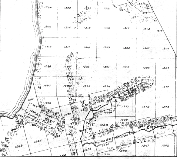
Such a search may indeed be necessary to answer questions about Pueblo Lot 1303, those 123 acres that now belong to Harry L. Summers. The city’s property department still seems to be unsure of just what public vote made possible Summers’ plans for a man-made lake along La Jolla Village Drive, with its surrounding 2500 condominiums. Greenleaf says, “Much of these holdings were a part of a proposed exchange of city-owned land for sites owned by Kahn, where the city wanted park sites, fire stations, and land for various public purposes.” That sounds a lot like the 1964 and 1968 propositions, but a check of the property department’s and the city clerk’s records of pueblo lots ratified for sale shows that those elections did not mention Summers’ Pueblo Lot 1303. In fact, those records, which include ballot propositions from 1949 forward to today, fail to show that Pueblo Lot 1303 ever was authorized by voters to be sold.
Discrepancies in the city’s records are minor, no doubt, considering how (nany other apparent problems Summers has surmounted so far in his progress through the planning department and other city and even federal agencies. The ten-acre lake, for instance, may lose 20 million gallons of water each year to evaporation alone; it may have to be drained and refilled every three to four years to control algae; and, according to a report certified by the city’s planning department, the lake will “remove all of the native and nonnative vegetation on the site, and, in doing so, it will eliminate most of the resident wildlife and avifauna.” All that sounds pretty grim, so Summers undoubtedly was greatly relieved when the city concluded that the lake will have no serious impact on the land.
Those eighteen-story “mid-rise” condos might also have been a problem, for one reason because they violate the Federal Aviation Administration’s height regulations near Miramar Naval Air Station. The FAA, however, smoothed things out by noting that “a structure [in this case two] that exceeds the standards is not necessarily a hazard.” But just the startling appearance of those towers on the mesa might have been enough to interfere with Summers’ plans had not the city planning department noted the following: “If this project is one of the first of many planned high-rise structures [somebody forgot the proper terminology] to be developed, it may result in an interim visual impact until further high-rise construction starts." (My emphasis.)
Could the planning department actually be suggesting that a few more high rises (or mid-rises) be built nearby, say, next door on Pueblo Lot 1304, that virginal property containing most of what’s left of our communal land? Apparently not, because our city planners seem to have other plans for Pueblo Lot 1304. The department’s recent report on the area acknowledges that this rapidly urbanizing, “close-in,” self-contained community (Summers’ project) has need of a school. The report promises that “the city planning department will recommend that an appropriate location for such a school is ... in the unratified pueblo lands to the east of [Summers’] Lake at La Jolla Village.”
We — you and I — will soon be asked to give away Pueblo Lot 1304. Judging from recent history, we will probably say yes. □
Here's something you might be interested in.
How San Diego lost its pueblo land
Property, power and greed
How San Diego lost its pueblo land
Property, power and greed
Lot 1304. We will soon be asked to give away Pueblo Lot 1304. Judging from recent history, we will probably say yes.
Out in the sprawling north of this city is a mesa that rises just south of La Jolla Village Drive, a mile or so west of Interstate 805. To get there you have to walk through dry grasses with wheat-like seed stalks that break off and stick in your socks, hop across vertically walled, deep runoff scars that plunge down ravines to sycamores on a creek bed.
Lot 1303. The mayor’s was one of six council votes that granted Summers’ request to change his 123 acres on Pueblo Lot 1303 from single-family to multiple-family zoning.
As you climb to the mesa the most evident signs of life are droppings — either the perfect super-BBs of the rabbits or the furry leavings of the coyotes that ate the rabbits. Chaparral, some of it burned, leaves black carbon streaks on your clothes. It’s this city’s typical undeveloped land: dry, rocky, and unshaded.
Fitch’s 1843 boundary line started at the southern tip of Point Loma and ran eastward into the Chollas Valley, then north some twenty-seven miles to its point of intersection with the sea at Carmel Valley (or Penasquitos lagoon), then south along the coast back to Point Loma.
Now, if you stand at a particular point on that mesa, and if you draw a line in the dirt from north to south and then straddle that line, you will have one foot on Pueblo Lot 1303 and the other on Pueblo Lot 1304 — one foot in San Diego’s future and the other in its past. The foot on Pueblo Lot 1303 is just inside the boundary of Harry L. Summers’ 121 acres, which he is going to fill with a ten-acre manmade lake ringed by 2500 condominiums. The other foot, the more easterly on Pueblo Lot 1304, is resting on land you and I own along with everybody else who lives inside the city limits — pueblo land.
The city proposed selling pueblo land (seen here) to Irvin Kahn to develop what would become University City.
Voters voted the idea down in 1961 and 1963.
This is not properly called city-owned land; it is land given us by the kings of Spain and held in trust for us by the city’s government. It is vacant and undeveloped — lot 1304 is virginal, really — because you and I have never voted to sell it. In the 1850s, there were more than 40,000 acres of this communal land in San Diego. Now there are something like 300 acres left, and most of these are here on Pueblo Lot 1304, next door to Harry Summers and within eyesight of University Towne Centre. We you and I — are probably not going to own Pueblo Lot 1304 much longer.
Much of the land . . . held by titles at least very doubtful, if not entirely fraudulent, has been divided up and sold to speculators who will endeavor to dispose of it to the new settlers at exorbitant profits.
So wrote Colonel R.P. Mason in an 1849 letter to Brigadier General R. Jones of California’s provisional government. Mason was commenting on a report on land sales in San Diego immediately after Mexico’s loss of California to the United States. His observations, distressingly applicable even today, were made just sixteen years after settlers here had gathered together in sufficient numbers to make a credible request of the recently established Mexican government for status as a pueblo, to form their own municipality.
When that request was granted in 1834, there remained to be resolved the question of how much land belonged to the pueblo, and exactly where that land ended and where there began the independent, private ranchos held by the backcountry dons. Eleven years passed before the local government finally ordered its Anglo legal counsel, Henry D. Fitch, a one-time sea captain whose map-reading skills were evidently believed to qualify him for the task of map making, to go out into the countryside, stake the pueblo’s claims, and then draw a map of those claims.
Fitch used the opportunity to expand greatly upon the boundaries originally (though not precisely) defined by King Charles IV of Spain in 1791. The crown had been eager to secure its new territory by encouraging settlement, and had declared this far-flung outpost of the Spanish empire to be a legitimate pueblo, a civil unit. The local pioneers were granted four square leagues (roughly seventy square miles) of land, to be divided up for various uses — common areas, government property, private development, and so on.
By the time Fitch was done with his mapping, however, the pueblo’s area had increased to eleven square leagues. Fitch’s boundary line started at the southern tip of Point Loma and ran eastward into the Chollas Valley, then north some twenty-seven miles to its point of intersection with the sea at Carmel Valley (or Penasquitos lagoon), then south along the coast back to Point Loma. The generally triangular shape of the area delineated by Fitch was presented in map form to Mexican Governor Pio Pico, who signed his approval early in 1846.
The transfer of authority in 1821 from the Spanish to the Mexican regimes had been relatively uneventful, and in the several decades of the Mexican period, government officials here went about their business of dealing out small plots to settlers and maintaining common areas for grazing and municipally owned tracts. When the American Navy landed at Monterey in 1846 and planted the stars and stripes there, the new military government of the United States did exactly what the Mexicans had done when they took over California from the Spanish king; it declared that all laws and property transactions of the previous regime would be honored under U.S. rule.
The U.S. Lands Commission was created to authenticate the titles of landholders and the extent of municipal bounds of the former pueblos, and in 1852 determined that “the president and the trustees of San Diego succeeded to all the claims of the former Mexican pueblo." The major exhibit was the Fitch map. (Los Angeles was not so lucky. That pueblo had never gotten around to drawing a map of its boundaries, and L.A. citizens have never been able to claim rights to pueblo lands.) A few years after the lands commission decision, a California Supreme Court ruling established that these lands were not absolutely owned by the municipalities “with full rights of disposition and alienation, but to be held by them in trust for the benefit of the entire community," thus continuing the chain of public trust passed first by the Spanish king to the pioneering residents and down to the municipal governments of American San Diego.
Either because the Mexican government and the Spanish before it did not intensely recruit settlers, or because the prospect of a grant of land was not accompanied by some additional lure — a gold strike or coal find — a population boom in pre-statehood San Diego did not occur. In fact, there is evidence that suggests many of those who came here in the middle of the Nineteenth Century sniffed the winds, took in only dust and fleas, and decided to remove themselves. In 1838 the population of the newly formed (and vast) Mexican pueblo sank below the required 500 minimum, and the official incorporation was repealed. Years later, just after California became U.S. property in 1850, San Diego as a city again lost its incorporation, and again a drop in the population was to blame. The new state legislature, in yanking away San Diego’s status as a city, took the precautionary measure of protecting the public’s pueblo land — it forbade the town’s trustees from selling any of the land unless it was to cancel old municipal debts. Local officials, however, ignored the law. E. W. Morse, one of those lucky buyers who later became a town trustee himself, managed in 1853 to convince the trustees to sell him 302 subdivided lots on pueblo land in Old Town for seventy-six dollars, or twenty-five and a half cents per lot. In a burst of sheer nerve, a trustee later sold himself more than ninety acres of pueblo land at a price he was careful not to allow disclosed in the board’s minutes. According to Harry Hopkins, a former deputy city attorney who in 1928 wrote a little-known history of the pueblo lands, "It looks very much as though the board met, each member took what he wanted, and let it go at that.” By the time E.W. Morse took his turn as a trustee in the mid-1860s, San Diego’s city center was still Old Town’s dusty plaza, the same one that Diane Powers in this century was to convert to a green gateway to her Bazaar del Mundo. But Alonzo Horton came to town in 1867, and he and Morse combined in a move that was to establish the city center at its present location, on the swampy edges of the little-used but deep and expansive harbor to the south. Morse and one of the other two trustees signed a deed granting 960 waterfront acres of pueblo land to Horton at the price of twenty-seven and a half cents per acre, only pennies more than Morse had paid for his land fourteen years earlier. According to Hopkins, and an earlier 1926 article in the San Diego Union by historian Daniel Cleveland, Horton turned over forty of those downtown acres to city father Morse the day after Morse and the other trustee signed the deed for the 960 acres.
Of course, land was cheaper in those days than it is now, but Horton, Morse, and others who shared in the spoils of early government were clearly getting deals of astounding value. When the land was auctioned publicly, it sold for far higher prices, and even then was probably auctioned only in amounts needed to pay the town’s bills. The same year Morse bought his 302 Old Town lots for seventy-six dollars, someone else was buying at auction 236 lots in the same Old Town area for a per-lot price forty times higher than that paid by Morse. Perhaps the biggest attempted giveaway came in April of 1870, when trustee Matthew Sherman and another trustee named Estudillo combined in a majority to vote an outright grant of 5000 acres — easily one-eighth of the remaining pueblo land, and probably more — to the San Diego and Los Angeles Railway Company in one of the many attempts to establish San Diego as a rail nexus. A year later the lone trustee who had not approved the grant joined with two new trustees in filing a legal action against that railroad grant. The grounds? Matthew Sherman was both a stockholder and officer of the railway company. The state supreme court declared the land transfer null and void.
By 1871, 13,000 acres of the original 47,000 acres mapped out by Fitch “had been given or sold to nonresidents, or to relatives or favorites of the city trustees,” historian Cleveland wrote almost fifty years ago, citing a Union article of 1871. He estimated that the city bought back various parcels, for civic uses, at a cost five times greater than the total collected in sales of the pueblo lots. The rapid trading away of communal land at discount rates had so alarmed the state legislature, according to Deputy City Attorney Hopkins, that a bill was passed in 1872 demanding that all the state’s cities sell pueblo land only at public auction rather than through the private negotiations that had been nearly standard procedure following statehood.
Whether or not the state did actually attempt to force the cities to auction the land when it was sold after 1872, the law was either ignored or it was already too late to do any good. By 1890, fully eighty-three percent of San Diego’s pueblo lands were in private hands; only about 8000 acres remained. A more enlightened citizenry at the turn of the century began awakening, after some prodding by influential leaders and the state legislature, to the reality of what had been lost. Some of the most scenic areas of pueblo lands, those at the northernmost end of Torrey Pines Mesa, were being leased in 1890 by the city council to sheep and cattle grazers whose campfires by design were claiming the mesa’s trees for fuel, or by accident when the fires spread. An influential George W. Marston (who later gave the city Presidio Park) persuaded other community leaders to encourage public support for a park on the mesa, and at the turn of the century the council was moved to set aside 369 acres (Pueblo Lots 1332, 1333, 1336, and 1337) to be “forever held in trust by the municipal authorities as a free and public park.” The more northerly stand of trees on the pueblo lots at the very border of the city’s limits (Pueblo Lots 1338 and 1339) had been sold in the 1870s to a man who was about to begin development there. Ellen Browning Scripps stepped in and from 1900 to 1904 managed to acquire those additional acres of trees. The Marston initiative and Scripps’s acquisitions formed the nucleus of the existing Torrey Pines State Preserve.
While those rescue operations were underway, laws were being drawn. An amendment to the city charter voted by the people in 1889 accomplished what the state had failed to do in 1872: no pueblo lands thereafter could be sold outside of public auction. The state legislature a year later slapped a thirty-year moratorium on the sale or lease of any pueblo lands, thus usurping the council’s prerogatives altogether. A charter amendment passed by the electorate in 1909 raised the prohibition further, extending to 1930 the ban against sales and compelling the council after the expiration of the moratorium to seek voter ratification of any sales of land north of the San Diego River (presumably because virtually all the land south of Mission Valley was already in private hands or had been repurchased by the city for public buildings). A 1931 city charter amendment replacing that 1909 section said virtually the same thing, but added that the council could lease pueblo lands for terms no longer than fifteen years. Neither of these laws, however, restricted the city to auctioned sales only; private negotiations could still take place, an accidental or purposeful omission that years later would lead to alleged abuses of the public trust. But the reforming zeal had fashioned some very stringent law, law which still binds the council and city officials today — at least theoretically.
- It is a shame that, despite the lip service given the pueblo land concept by Nineteenth Century American administrators, our California pueblo lands were squandered away by generations of unthinking municipal officials. — City Attorney John Witt, 1977
How this city went from a communal holding of some 8000 acres of pueblo lands in 1890 to today’s paltry 300 acres is a disheartening story, though one somewhat more free of official greed and venality than that of the notoriously individualistic Nineteenth Century.
Much as it did in 1979, the Navy in 1919 took a look at Balboa Park and saw a hospital there. The city gave up seventeen acres of pueblo land on the high ground that year and belatedly asked the voters for approval in 1920 (though nothing in the charter demanded it do so, since the park was south of Mission Valley). The Navy’s special status also won for it pueblo tidelands for t|ie Naval Training Center on Point Loma, a refueling station, and the area around the foot of Broadway. From 1920 through 1941, more land in Balboa Park was taken to expand the hospital, on four different occasions. Also in the same period, after the moratorium expired north of the river in 1930, pueblo lands near what is now Miramar went for rifle ranges, more tidelands went for repair stations, a National Guard armory, and for what is now the Coast Guard air station on Harbor Drive — all of those grants being approved by a patriotic electorate.
Also in this period and after World War II, Collier Park in Ocean Beach began disappearing, portions of it in 1937 for a school and construction of a street, more of it for streets in 1951 and still more of it in 1953 for a home for unwed mothers, all approved by the electorate, though the charter did not demand the city seek the vote. (The park is now gone altogether.) In 1948 conveyance of Torrey Pines Park to the state, which did require a vote, was accomplished on the ballot. The homebuilders were moving in now, and various pueblo lots (most of which measured just under one square mile) were being mapped and subdivided, and sewers and water lines were dug in preparation for development. Much of the lush La Jolla Shores Drive area was being sold by the city in 1951, for example. In one case, the city hired an appraiser who came in with an estimate that the twenty acres of Pueblo Lot 1297, just east of La Jolla Shores Drive between Camino del Corta and Camino del Collado, were worth $2000 an acre. At an auction in the property manager’s offices on November 21, 1951, Richard Gill and Arthur A. Seeligson, the sole bidders, paid exactly the minimum bid set by the appraisal — $40,000 for the twenty acres. But the cost to the city for improving the lots and readying them for the sale was nearly the same as or even more than the sale price. On nearby Pueblo Lot 1299, for example, thecity was spending $2450 per residential lot to install sewers, water lines, and cut streets.
Five years after the two lone bidders won the La Jolla Shores acreage, General Atomic was able to pick up similarly desirable property on Torrey Pines Mesa for its huge lab, the first onto the mesa of a now-familiar wall of high-tech palaces. General Atomic fared even better than the developers at the shores — its 320 acres of pueblo land came from the city free of charge. (The same year General Atomic received its gift, somebody elsewhere in the city was buying forty-five acres of pueblo land at a per-acre price at $4278. Another auction in 1958 of sixty-five acres brought a per-acre price of $6350.)
Enter now the 1960s. the era when most of us became aware that land was scarce and growing scarcer, even here in sleepy San Diego. There was afoot in city hall a notion to divest the city (its citizens, really) of all the remaining 2100 acres of pueblo lands that had not at that point been subjected to a public referendum. It was a quixotic move, considering that the voters were getting a bit suspicious of their elected representatives. In 1961 an attempt to sell more pueblo land was defeated at the polls. Two years later the council and its manager, Walter Hahn, were careful to explain the matter more fully. Most of the 2000-odd acres proposed for sale in 1963 would go to Irvin Kahn’s University City Corporation to develop the area that now bears his company’s name. Kahn had holdings all over the city’s north, but they weren’t contiguous; what he and the city’s elected and unelected officials wanted to do was trade away the unbroken, large pueblo lots to him for the smaller slivers and scraps that Kahn had collected. In addition, Kahn was going to buy outright some of the acreage. The city told voters that the Kahn properties it wanted to exchange for the pueblo lots would be used for park and school sites. A sharp-eyed citizen raised the embarrassing question of how the city would “earmark" those pueblo acres to Irvin Kahn when manager Hahn was also saying publicly that “all sales will be through public auction.” A week or so before the vote was scheduled, Hahn attempted to explain that Kahn would “probably” be the highest bidder because he could develop the land at less expense than anyone else. The proposition went down to defeat in November, 1963.
Wiser, but no less committed to the University City idea, the council and its manager months later dragged the Kahn package out of the ashes, this time in a confusing three-part set of propositions. The first two propositions put before the voters in 1964 specifically listed what uses would be put to something less than 1000 acres of pueblo lands — a more palatable number of acres considering the defeat the previous fall. In the first proposition, some 600 acres — along Torrey Pines Mesa, an area east of Interstate 5, and parts of Sorrento Valley — would be opened up to research and development, housing, Scripps Memorial Hospital, and, in smaller amounts, railroad, utilities, and telephone easements. Roughly 340 additional acres would be opened up in University City for Kahn. Each of the propositions carried the promise that schools would be part of the uses “and suitable provision shall be made for the preservation of park sites and open space for public use.” The council took a deep breath and went for broke with the third proposition. It asked voters to do away altogether with Article 14, section 219 of the city charter, that troublesome prohibition on pueblo sales without voter approval. Passage of the third proposition would have made passage of the other two meaningless and unnecessary. When the polls closed, the voters had approved research and development along Torrey Pines Mesa and Sorrento Valley, a hospital for Scripps, housing in those areas, and Kahn's projects for University City nearby. However, the repeal of section 219 failed. There were still some 1,300 acres of pueblo lands whose fate remained more or less in the electorate’s hands.
In the mid-1950s San Diego officials were just beginning to hear the siren song of so-called clean industry that later was to develop into a Sun Belt obsession. The General Atomic deal was the first success, and out of it sprang something called the Industrial Development Commission, a city-funded search committee that would try to locate clean companies interested in moving here. “It was pretty clear that this town desperately needed to diversify its base in order to mitigate the boom-bust cycle,” recalls Superior Court Judge Ed Butler, who around the time of the formation of the commission was an attorney employed by an electronics firm newly arrived from Los Angeles. Butler plugged himself into city hall fairly quickly on his arrival (the mayor at that time, Charles Dail, heard that Butler’s company was shopping around for insurance, and one day drove up in the city’s limousine to ask why his own insurance company hadn’t been asked to write the policy; Dail got the insurance business) and by 1963 he was the chairman of the Industrial Development Commission, on his way eventually to becoming city attorney under the incoming mayor, Frank Curran. It was Butler, too, who was in the middle of the campaign of city officials to overturn the charter amendment forbidding sale of pueblo lands without popular vote. Harry Schei-dlc, then a council member and later to move over briefly to the county board of supervisors, recruited Butler to put together the repeal attempt.
Unsuccessful though they were, the advocates of industrial parks on pueblo lands (Curran among them) decided to put together a stronger entity to replace Butler’s commission, something that would be called the Economic Development Corporation (EDC). “I became persuaded the city [council and staff] was totally incapable of dealing eyeball-to-eyeball with all the soft-shoe artists who were coming to town,” Butler remembers. “Curran adopted the EDC as a plank in his campaign.” When Curran was elected, he appointed Butler city attorney with the mission of developing the EDC.
From 1966 to 1977 the EDC went about filling the vacant places in Sorrento Valley and in Kearny Mesa with a considerable amount of negotiating autonomy. It could zero in on firms likely to buy property, negotiate the selling prices based on independent appraisals (the EDC did not conduct auctions), agree to the timetables of construction, landscaping, and so on — because, through an agreement with the council. EDC owned the voter-approved pueblo lands and other city-owned parcels it was peddling. Any “profit” the EDC recorded in brokering the sales was deposited into a separate fund, which in turn financed site preparation for additional sales in the industrial parks.
The general idea about the two major industrial parks — Sorrento Valley’s and Torrey Pines Mesa’s — was that the former could be open to a variety of uses, but the mesa’s should closely conform to the prestigious one of advanced technical research, with some product applications. The future denizens of the mesa, after all. were to be joining the company of General Atomic and Salk Institute, and were within a leaf's fall of the eucalyptus groves of UCSD, which itself had been created partly out of a 450-acre grant of pueblo lands in 1958. Right at the outset there was some official squabbling over the limitation of the mesa to pure research and development. “We are tying our hands with a strict research-and-development classification,” the new city attorney, Ed Butler, complained, just before the three ballot propositions of 1964 were put before the voters. “North American Aviation refused to invest $50 million in research facilities here because of the ambiguities latent in those terms.” (These ambiguities were later replaced by near-total permissiveness under the present regime at city hall.)
Throughout the 1960s, the EDC and city council were well able to fill Sorrento Valley with industrial users, and were even better able to fill the bluffs east of Interstate 5 with houses. But at Torrey Pines Mesa sales were slow. It was a period of intense citizen interest in securing more of the mesa for public uses, and cramming the mesa with research companies might not have been a popular position for coun-cilmcn to espouse. Also, there was Butler’s earlier complaint that potential users of the mesa felt loo constrained by the limits of the “science-research” zone.
The next attempt to win voter approval to sell more pueblo land came in 1968, with Proposition C. This was a more modest package involving the transfer of 152 acres to the state for continuation of Interstate 805 from roughly the Governor Drive area northward to its present link with Interstate 5, a road that originally was to be called the Boundary Freeway, in recognition of its near conformation to the eastern edge of the old Fitch map. Another fifteen acres was to be transferred to the school district for an elementary school in the burgeoning area around what is now University Towne Centre. Finally, ninety-three acres of land would be used for yet more housing around the Towne Centre site then owned by Kahn, and in an area north of Governor Drive. The proposition was followed by arguments in favor, from property director William MacFarlane, and arguments against, from resident Lauralee Bennet. MacFarlane assured voters that “proper consideration has been given to lands which should be retained by the city for park sites and open space as designated on the University Community Master Plan.” Said Lauralee Bennet, “Are we to dispose of these [acres] in the face of the growing need for more open space as our population expands? When we have disposed of the last of our pueblo lands, are we then to turn about and begin to acquire open space which assuredly can then be obtained only at enormous cost and inconvenience?” The proposition passed, in very light voting, 89,000 to 75,000. Today, eighteen years after the 1964 propositions and fourteen years after Proposition C, no public parks have been developed on the pueblo lands that were sold; the nearest is Eastgate Mall Park, ten acres of empty land, on five of which the Jewish Community Center is seeking to build a recreation center in a kind of joint development with the city, leaving the other five to conventional parkland. Both the Jewish Community Center and the parklands will be open to public use.
The new mayor who came to city hall in 1971 was armed with a lot of pueblo territory previously ratified for sale but as yet unsold. Not counting the Torrey Pines golf course and Soledad Park, there were just a little less than 900 acres of pueblo lands over which the voters maintained control. It was to be nine years before this mayor, Pete Wilson, sought ratification for the sale of most of that public property, but in the meantime there already was most of Torrey Pines Mesa, a lot of Sorrento Valley, and portions of Kearny Mesa waiting for buyers. The mayor set about making Torrey Pines more attractive to prospective tenants.
The “science-research” zone that governed development of the mesa in 1973 strictly limited the city council’s options; the ordinance stated that the land so zoned could not “be used for any purpose other than scientific research and development.” It restricted any manufacturing to prototypes, compounds used in research labs, and to experimental products (it did allow the manufacturing of equipment to aid production elsewhere).
By August of 1975, however, the science-research zone had been amended to permit “headquarters or administrative offices.” The final version of the ordinance came out reading thus: “The . . . zone is intended to provide areas for scientific research and administration of related products and for uses which the planning commission may find to be compatible with these uses and in the public interest.” The section on permitted activities of this final version eliminated the highly restrictive “no other” prohibition against activities and simply said that among the permitted uses were “headquarters or administrative offices of firms engaged in research and development on the premises.” That “headquarters” section was later interpreted to allow virtually any corporation onto the hallowed ground that Salk and General Atomic first inhabited — from life insurance companies to computer hardware firms. The most outstanding relaxation, though, lay further down in the new section concerning permitted uses. Clause 7 read: “Any other use which the Planning Commission may find to be similar in character or compatible to the uses, including accessory uses, enumerated in this section and consistent with the purpose and intent of this zone.”
Armed with those broad, relaxed limits, the EDC went out and began finding buyers, buyers who were particularly gladdened to find that they were also getting significant price breaks. Some outstanding examples that later came under investigation:
— Ramco, a firm researching thermal . energy Fields, bought 3.32 acres in May of
1978 at $1.22 per square foot.
— Jaycor Associates, a Del Mar research and development firm, bought 3.28 acres in July of 1978 at $2.35 per square foot.
— Torrey Pines Properties, Ltd., owned by developer Douglas Manchester, bought 6.15 acres in September of 1978 at $1.38 per square foot.
— Life Insurance Company of California (Cal Life) bought 14.38 acres in July of
1979 at $2.25 per square foot.
— Signal Companies, Inc., bought 8.68 acres in September of 1979 for $2.45 per square foot.
These are property values that are incomprehensible to those who don't deal in real estate of the magnitude and quality of Torrey Pines Mesa, but there were people at city hall who understood those figures, and began checking them against other properties on the private market. At the same time the mesa sales were taking place, an industrial park at Mira Mesa, for example, was getting anywhere from $6.06 to $9.34 per square foot for its 1.3-to four-acre parcels. At a July, 1979 meeting of the council's public facilities and recreation committee, council member Fred Schnaubelt guided to the microphone a Coldwell Banker appraiser familiar with Torrey Pines property and asked him his opinion of the value of the 8.68 acres of land that Signal was about to purchase from the city for $2.45 per square foot. “1 would think,” said the appraiser, “that the estimate of value would be at least five dollars per square foot. For smaller parcels in the one-, two-, or three-acre range, given the same assumptions [of various shaped lots]. I’d think you’d be be looking at probably seven and eight dollars per foot.” The appraiser had already taken into account that the Torrey Pines land might be discounted below other industrial lands because of the putative limitations of its use for science and research. In other areas, he said, naming Kearny Mesa, lots without those restrictions (restrictions which had for practical purposes been removed at Torrey Pines by the mayor and council) the lots were selling from $7.50 to ten dollars per square foot. It was fairly stunning testimony, since the city seemed to be giving up half and perhaps two-thirds of the selling prices it could be getting — prices that were ranging from $335,000 to one million dollars.
Schnaubelt went away shaking his head and ordered city auditor William Sage to study the sales. What came out of Sage’s office indicated that there was a strange breakdown of council policy in a number of areas — the companies were failing to meet even the relaxed requirements of the new science-research zone, not to mention other council policies on development in industrial parks.
Schnaubelt was laboring under the belief that council policy generally prohibited the sale of land (this is pueblo land, remember?, held in trust for the benefit of all San Diego citizens) in the science-research zone to parties who would immediately turn around, improve it, and sell it for profit. In fact, most or all contracts between the city (in the form of the Economic Development Corporation) and companies moving to the mesa contained clauses that seemed to say that the buyers would actually use the buildings for their own businesses. Sage had to disabuse Schnaubclt of that belief. “A review of council policies in effect during and subsequent to these negotiated sales,” Sage wrote on the cover of his report to Schnaubelt, “revealed no written [the emphasis is Sage’s] policy explicitly prohibiting speculation.” Sage recommended to Schnaubelt (and presumably to the mayor and other council members) that in the future, the city should more carefully spell out in contracts that it has the right to repurchase the property if the “science” buyer attempts to sell it at a profit.
What had piqued Schnaubelt’s interest in the question of speculators’ dealings on the mesa were the Jaycor purchase and the purchase listed above as that of Torrey Pines Enterprises. A year after Jaycor bought its property the entire company and its assets was purchased by Douglas Manchester’s real estate development firm, Torrey Pines Enterprises. The Jaycor sales contract worked up by the EDC and other city departments contained what is known as a reversionary clause, which stated that the city would have first rights to buy back the parcel at its Jaycor sale price should Jaycor try to resell the property within three years of its purchase from the city. Such clauses are the city’s protection against speculation by firms that might be tempted to turn a quick buck rather than use the property for its intended purpose — that of ongoing scientific research. Auditor Sage, together with the city attorney’s office, found that the reversionary clause could not be enforced because Jaycor, now just a paying tenant in Manchester’s building, did not simply sell Manchester the land but its entire business, and “the reversionary clause did not prohibit the sale of the partnership.”
Another Manchester purchase was even stranger. It began in December of 1977 when the EDC found a company named Teleflorist, Inc., that was interested in building a corporate office on 6.15 acres across from the golf course on Torreyana Road. Escrow was opened with Teleflorist early in 1978, but in less than two months the EDC was informed by Teleflorist that new buyers’ names should be added to the deed instructions, and that the Teleflorist purchase had become a joint venture with a Redondo Beach firm called Flowtrans Associates, another firm called University Financial Associates, and two individuals named Richard I. Redmond and Charles L. Kendrick. A further change in the escrow papers took place some months later in August, when the EDC learned that Teleflorist and the joint venturers had ended their joint venture, and that in fact Douglas Manchester was now the buyer who would lease the future buildings to Teleflorist. So Manchester’s name was then written into the escrow instructions as the actual buyer. This put the council in the difficult position of having to sell “science-park” property to a real estate development firm, but the city manager told the council that “the lease between Torrey Pines Properties, Ltd., and Teleflora, Inc. [there was no explanation for that name change] appears appropriate provided Teleflora is the sole occupant of the property.” So the council bit its collective lip and sold to Manchester in fall of 1978. Manchester erected two 40,000-square-foot buildings that opened in spring of last year. Teleflorist and/or Teleflora are not occupants of either building. The main tenant is Management Analysis Company, a firm that “specializes in management services for the energy field,” a use that apparently satisfies the science-research zone requirements. Other subtenants (those leasing from the energy consultant) are directly involved in scientific research, but there is a travel agency busily booking flights in the building — presumably in a very scientific manner — and that use of the building was also permitted (though Sage objected to it as a violation) by the city attorney’s office, which found that the company was making travel arrangements for the employees of the energy consultant firm. The travel agency, Park-N-Go, was allowed to stay in Manchester’s building as long as it had no outside public entrance or signs. The city attorney’s office agreed with Sage that “Torrey Pines Properties [Manchester] does not appear to qualify as a user of property in the science-research zone. However,” the letter to Sage continued, “we find nothing in the purchase agreement between the Economic Development Corporation and Torrey Pines Properties, Ltd. that required it to so qualify and since Torrey Pines Properties, Ltd. is not attempting to use the property itself, we find no violation of any provision of our code. ...”
Still other city regulations seemed to have been clearly violated, though again no action was taken by the city attorney. To his credit. Sage pointed them out. The council’s policy that pertains to the sale of industrial-park property requires that the EDC provide a fair-market appraisal of the property that is no older than six months at the time of the council’s deliberation. The Teleflorist/University Financial/Manchester appraisal was a full seventeen months old at the time the property was sold. Elsewhere, on nearby Campus Point across Interstate 5, where TRW, Inc., in 1980 bought some six acres from the city, a committee consultant had found the sale price too low, and based on a year-old appraisal. Those points were not addressed by the city attorney.
The Signal Companies and Cal Life deals were apparently negotiated in large part by Mayor Wilson personally. The September 13, 1979 edition of the Los Angeles Times carries a story written by George Frank that states Wilson, Signal Companies president Forrest Shumway, Gordon Luce, president of San Diego Federal Savings and Loan and then chairman of the EDC, and city manager Ray Blair all met downtown at the Executive Hotel on June 24, 1978 to discuss Signal’s move and quotes Wilson as telling Shumway, “We would try to do everything we legitimately could to assist them in coming.” A city official active in the Cal Life negotiations says comments were made at city meetings that Cal Life had been very helpful in selling the Torrey Pines Mesa lots to other buyers and that Wilson had directly talked to that company about coming to the mesa. In both cases the companies were granted waivers of several council policies, including setting the minimum number of employees based on the number of acres purchased. The policy sets a standard of at least thirty employees per acre.
Signal was allowed to employ just less than ten per acre. And unlike other companies, Signal received city-paid improvements at the site.
Cal Life was bought by the stock brokerage of E.F. Hutton in February of 1978, but it was not until after the sale of the property that the company assumed the Hutton name. Someone had brought to Schnaubelt’s attention an advertisement in the November, 1980 California Business News by Hutton offering leased office space in the company’s six buildings totaling 332,000 square feet. Schnaubelt again wanted to know if E.F. Hutton was violating conditions of the sale by turning a profit on leasing arrangements. Sage replied in his report, “Apparently, the Life Insurance Company of California [Hutton] was sold land in excess of known current and future needs, permitting its successor, E.F. Hutton Life Insurance Company, to speculate on the unneeded portion.” Of the two Hutton buildings already up. only one is occupied by Hutton. The other, some 108,000 square feet, is being leased by a company its landlord refused to reveal to Sage. As to whether Hutton is a proper science-research zone tenant, the city attorney simply took the position that the company “does meet the standards and criteria set forth . . . relating to the . . . zone.” Senior chief deputy city attorney Curtis Fitzpatrick did conclude, however, that Hutton's life insurance branch should be required by its contract “to use its good-faith best efforts to eventually utilize all of the office space [the total number of buildings approved is now eight, with 499,000 square feet] for its national [life insurance only] headquarters operation. In the interim.” Fitzpatrick went on, “the company may lease space in excess of its current needs to users who meet the science-research zone requirements.” In many of the contracts issued by the Economic Development Corporation, “official” requirements have been either waived or written in language the city attorney found unenforceable. Deputy City Attorney Hal Val der Haug recalls that the early EDC contracts were loose. “They could have been tighter as far as specific dates [of construction starts] and employment numbers are concerned. We were bending over backwards to get some of these people to come here. We didn’t place as many restrictions on those contracts.” No two contracts have the same restrictions, Val der Haug says, even though standards set by council policy are specific. “You have to look at each contract, one by one,” says a property department worker, “to find which companies got the sweetheart deals.” Judge Ed Butler, who set up the EDC. says in the early days the contracts were strict. “We had such severe restrictions on landscaping, employment numbers, on-site improvements . . . they [companies looking for sites] could do it more cheaply on private land.” Butler indicates he doesn’t like what became of EDC and the development agreements he helped set up. “We succeeded too well.”
As to Sage’s belief that some of the science-research zone users were in violation of leasing restrictions, employment minimums, and other aspects of council policy designed to prevent the growth of the zone into a generalized place of business, Deputy City Attorney Fitzpatrick says, "Some of the problems were misunderstood by the auditor’s office.” Responses from the attorneys and Sage to Schnaubelt’s questions began flowing in May of 1981 and continued into September of that year. “Schnaubelt didn’t say anything,” Fitzpatrick says, “which I took to mean he was either satisfied or didn’t care any longer.”
Schnaubelt made one more run at city policy before stepping down from office. He gave the 1979-80 grand jury a ten-page analysis of city land sales by negotiation as compared to auctions and a survey of other states’ laws on land sales, compiled by a law school student who was interning in his office. “Between January, 1978 and August, 1979 the City of San Diego sold fifty-six parcels of surplus property,” Schnaubelt told the jury. “Thirty-three of these were through private negotiated sales and twenty-three were through the open bidding and public auction process.”
The report explained that the twenty-three auctioned parcels had been appraised at $7,548,350. but were sold by the city for far more — $11,250,250, approximately forty-nine percent more than their appraised value. If the forty-nine percent average mark-up had been applied to the negotiated sales, which were based on the city’s independent, contracted appraisers’ valuations, the city would have made $4.5 million more on those negotiated sales than it did, Schnaubelt contended. He explained that while California has no state law that compels governments to auction their public land (though the state apparently once did have such a law and, at least for a while, so did the city) many highly urbanized states require public auctions. Schnaubelt suggested to the grand jury that the city should be made to show that its discounts were not a “breach of trust and a fraud upon the taxpayers,” as a court in Illinois found in a ruling on the sale of property there for less than the highest available price. Laws and rulings from New Jersey, Florida, and Pennsylvania courts were also cited in Schnaubelt’s report to the grand jury, but as in the case of his protests to Sage and the city attorney’s office, he did not get the response he wanted. He had been hoping for a civil investigation of the negotiated deals, something the grand jury can do under its governmental watchdog powers, but all he got was a letter telling him there would be no investigation. “If I remember correctly, they said simply that under California law, it’s legal. The city can do whatever it likes with the land — give it away for that matter.” Schnaubelt’s still hot today, speaking from the real estate office where he works. “When you negotiate, it’s an insider deal,” he says. “If Signal or E.F. Hutton buys land at half price from the city, am I personally benefited? The stockholders of those companies may benefit, but I don’t think citizens do."
By late summer and early fall of 1979, the mayor was running for re-election after a tentative try at the governor’s office. His principal opponent, the former newspaper publisher Simon Casady, had picked up the land-sales issue and in an imprudent moment had called Wilson a liar for having denied that he sold favorable votes to campaign contributors. Casady was talking about the 1978 donation of $1500 to the mayor’s aborted race for governor by Forrest Shumway, president of Signal Companies, at about the same time the two had met in the Executive Hotel to talk about Signal’s move to Torrey Pines Mesa. But he was also talking about what developer Harry L. Summers had done for the mayor’s gubernatorial campaign in 1978. Summers threw a party at his La Jolla home that raised $70,000 for the mayor, and then he kicked in $4500 of his own to the campaign. Summers also had signed on as a guarantor of $5000 of a $100,000 loan to the campaign by Security Pacific Bank.
Early the next year, on January 2, 1979, the mayor’s was one of six council votes that passed an ordinance granting Summers’ request to change his 123 acres on Pueblo Lot 1303 from single-family to multiple-family zoning, with a pocket of commercial zoning included. The property had been part of Irvin Kahn’s holdings and had passed into the portfolio of Genstar Development, Inc., a huge Canadian firm that had planned for it a conventional subdivision of single-family homes, a much less dense and less ambitious project than the one Summers envisioned. When Summers bought the property, he began planning for two eighteen-story “midrises,” as the height was euphemistically termed by planners who were aware that Miramar Naval Air Station is less than three miles away. The other dwellings would be in fourplexes, raising the density far above Genstar’s original plans, which is why Summers needed the zoning change.
Today Casady still talks about our inherited lands in pretty much the same way he did when he ran against Wilson. “Pueblo lands have been the medium through which pols have climbed. They’ve used them like beads, cutting off one when they needed to raise some money. It’s been so open. If it had been done covertly, people would have gone to jail.”
Well, certainly no one has yet gone to jail, but those municipal officials who are supposed to act as our trustees in guarding the remaining pueblo lots continue to irritate people like Casady. Coincidentally, this very date of publication, July 22, is the scheduled day for opening arguments in a superior court lawsuit that accuses our city administrators of abusing pueblo lands.
The city wants someone to build a "large resort hotel with 500 to 600 rooms” on some twenty acres of Torrey Pines golf course (pueblo property), or, failing that, get the Torrey Pines Inn’s owners to add anywhere from seventy-five to 200 rooms to that establishment. In either case, the city wants Scripps Clinic to build an aerobic center to “house exercise, education, training, and therapy facilities” that hotel guests, clinic patients, and the general public could use at a site only a couple of minutes’ jog from the area purchased by Ellen Browning Scripps for a preserve eighty years ago. Golfers, many of whom also happen to be members of the Torrey Pines Protective Association, are suing the city over this, asking for an injunction against any award of bids for the hotel construction. The golfers argue that the city charter amendment concerning pueblo lands that was passed in 1931 on its face forbids the city to do what it would like to do. The relevant passage of that section says that “no lease shall be valid for a period of time exceeding fifteen years.” Negotiators for the city have already told prospective hotel companies that their lease agreement is “not to exceed fifty years.” City Attorney John Witt responded to the suit of the golfers by writing that “because defendants [the city] have previously leased pueblo lands for a period exceeding fifteen years . . . and taxpayers in the city have been aware of the leases and have not challenged them,” the court should dismiss the suit. (Back in 1975, Witt and the council sought voter approval of an ordinance that would have changed the 1931 law to allow fifty-five-year leases, but it failed to win.) One of the leases longer than fifteen years to which Witt was referring was that for the Torrey Pines Inn, granted in 1956. Critics of long-term leases point out that the city has fared miserably on them. Last fiscal year, under the complicated leasing agreement signed almost twenty years ago, the Torrey Pines Inn paid the city rent of about $90,000, not even a tenth the price real estate experts say it should be paying.
There’s more to irritate critics like Simon Casady. For example, after a successful 1979 campaign to authorize the sale of more pueblo land in Sorrento Valley (the yet unrealized profits from which are supposed to finance police substations), we appear to be left with only about 300 pueblo acres — from the original 47,000. But that figure, 300 acres, is, as the property department’s Dick Greenleaf puts it, “a WAG — a wild-arsed guess.” The fact is that the city’s records of pueblo land dealings are a mess. As long ago as 1968 the problem was acknowledged publicly. Tribune reporter Ken Rhodes at that time talked with then-property director William MacFarlane, who admitted to Rhodes that “over the years, many pueblo land transactions have been recorded, but others have not.” MacFarlane went on to describe how the “city records are lacking on much of the transactions, and that a search by a title firm might be necessary to find details.”
Such a search may indeed be necessary to answer questions about Pueblo Lot 1303, those 123 acres that now belong to Harry L. Summers. The city’s property department still seems to be unsure of just what public vote made possible Summers’ plans for a man-made lake along La Jolla Village Drive, with its surrounding 2500 condominiums. Greenleaf says, “Much of these holdings were a part of a proposed exchange of city-owned land for sites owned by Kahn, where the city wanted park sites, fire stations, and land for various public purposes.” That sounds a lot like the 1964 and 1968 propositions, but a check of the property department’s and the city clerk’s records of pueblo lots ratified for sale shows that those elections did not mention Summers’ Pueblo Lot 1303. In fact, those records, which include ballot propositions from 1949 forward to today, fail to show that Pueblo Lot 1303 ever was authorized by voters to be sold.
Discrepancies in the city’s records are minor, no doubt, considering how (nany other apparent problems Summers has surmounted so far in his progress through the planning department and other city and even federal agencies. The ten-acre lake, for instance, may lose 20 million gallons of water each year to evaporation alone; it may have to be drained and refilled every three to four years to control algae; and, according to a report certified by the city’s planning department, the lake will “remove all of the native and nonnative vegetation on the site, and, in doing so, it will eliminate most of the resident wildlife and avifauna.” All that sounds pretty grim, so Summers undoubtedly was greatly relieved when the city concluded that the lake will have no serious impact on the land.
Those eighteen-story “mid-rise” condos might also have been a problem, for one reason because they violate the Federal Aviation Administration’s height regulations near Miramar Naval Air Station. The FAA, however, smoothed things out by noting that “a structure [in this case two] that exceeds the standards is not necessarily a hazard.” But just the startling appearance of those towers on the mesa might have been enough to interfere with Summers’ plans had not the city planning department noted the following: “If this project is one of the first of many planned high-rise structures [somebody forgot the proper terminology] to be developed, it may result in an interim visual impact until further high-rise construction starts." (My emphasis.)
Could the planning department actually be suggesting that a few more high rises (or mid-rises) be built nearby, say, next door on Pueblo Lot 1304, that virginal property containing most of what’s left of our communal land? Apparently not, because our city planners seem to have other plans for Pueblo Lot 1304. The department’s recent report on the area acknowledges that this rapidly urbanizing, “close-in,” self-contained community (Summers’ project) has need of a school. The report promises that “the city planning department will recommend that an appropriate location for such a school is ... in the unratified pueblo lands to the east of [Summers’] Lake at La Jolla Village.”
We — you and I — will soon be asked to give away Pueblo Lot 1304. Judging from recent history, we will probably say yes. □
Comments