Here's something you might be interested in.
Ask a Hipster — Advice you didn't know you needed
Big Screen — Movie commentary
Blurt — Music's inside track
Booze News — San Diego spirits
Classical Music — Immortal beauty
Classifieds — Free and easy
Close to Home — What it’s like on the street where you live
Cover Stories — Front-page features
Drinks All Around — Bartenders' drink recipes
Excerpts — Literary and spiritual excerpts
Feast! — Food & drink reviews
Feature Stories — Local news & stories
Fishing Report — What’s getting hooked from ship and shore
From the Archives — Spotlight on the past
Golden Dreams — Talk of the town
The Gonzo Report — Making the musical scene, or at least reporting from it
Letters — Our inbox
Movies@Home — Local movie buffs share favorites
Movie Reviews — Our critics' picks and pans
Musician Interviews — Up close with local artists
Neighborhood News from Stringers — Hyperlocal news
News Ticker — News & politics
Obermeyer — San Diego politics illustrated
Outdoors — Weekly changes in flora and fauna
Overheard in San Diego — Eavesdropping illustrated
Poetry — The old and the new
Reader Travel — Travel section built by travelers
Reading — The hunt for intellectuals
Roam-O-Rama — SoCal's best hiking/biking trails
San Diego Beer — Inside San Diego suds
SD on the QT — Almost factual news
Sheep and Goats — Places of worship
Special Issues — The best of
Street Style — San Diego streets have style
Surf Diego — Real stories from those braving the waves
Theater — On stage in San Diego this week
Tin Fork — Silver spoon alternative
Under the Radar — Matt Potter's undercover work
Unforgettable — Long-ago San Diego
Unreal Estate — San Diego's priciest pads
Your Week — Daily event picks
During pandemic San Diego bicyclists push street closures
Howard St. in North Park, Diamond St. in Pacific Beach, Adams Avenue bridge
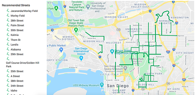
Draft of streets to be closed in city council district 3
The initial push behind the Slow Streets project launched by Mayor Kevin Faulconer on Wednesday evening – at the behest of a coalition of cycling and climate change lobbyists – was opposed by all but one of the business improvement districts that met virtually with City Councilmember Chris Ward last week.
“People saw the BikeSD plan and flipped out,” says Benjamin Nicholls, executive director of the Hillcrest Business Improvement Association. “This is so opportunistic. Businesses are shuttered and the bike community comes in with this plan to take advantage of their inability to participate.”
Nicholls isn’t the only person who sees the moves – happening all over the country – as exploiting the COVID19 pandemic to push through unplanned changes to cities without having to deal with public input from the people most affected. Twitter is full of conversations – both from the cycling advocates and from people worried about the imposition of such change without hearing public input.
Besides the business groups, there’s no mention that the plan went to any of the community planning groups.
The mayor’s final plan was a significantly toned-down version of what was originally proposed April 14 by a coalition of groups including many whose members serve on the recently created mobility board. While Ward’s plan expanded the number and miles of streets to be partly closed to vehicles for pedestrian and bicycle use, Faulconer’s final plan moved closures to just a handful of residential streets.
Faulconer’s communications staff say the bits included about a mile on Howard, which becomes Orange Street, all in North Park between Florida Street and the I-15, and about a mile and a half of Diamond Street, about three blocks north of Grand Street in Pacific Beach. It contains only the Adams Avenue Bridge over the 805 freeway.
It isn’t clear how mayor selected the streets to be included in the pilot project, but the mayor’s office says its input came from council offices.
The streets named last week are in District 2 (Diamond St.) and District 3 (Adams and Howard).
Ward, in District 3, has the largest number of business improvement districts within his council district (10 of the city’s total of 18), spanning the area west of the 15 to south of downtown to the Gaslamp Quarter. While the lobbyist-led effort targeted main and collector streets, Ward’s final proposal moved the street closures to neighborhood streets near more heavily used streets.
Insiders say only the Gaslamp Quarter Association BID favored the lobbyists’ original plan that included partial closure of 6th Avenue, in part because the district has long wanted to close 5th Avenue to vehicles.
Nicholls credits Ward with removing Adams Avenue from the map after the Adams Avenue Business Association vehemently opposed the plan that would have had to either remove parking or a travel lane to be implemented.
“It’s to Councilmember Ward’s credit that he heard and responded to the concerns,” Nicholls says. “His plan was toned down and mayor’s plan was more toned down.
No one seems to know how the Adams Ave. bridge ended up back on the map. The current slow streets effort will limit vehicle traffic on about 1.5 miles of Diamond Street in Pacific Beach, a mile on Howard /Orange Street in North Park, and inexplicably, for the length of the Adams Avenue bridge over the 805. No other parts of Adams, including the transition back to busy street are included.
The pilot project is being framed as a response to social distancing problems among the self-propelled, numbers of whom, anecdotally, have increased during the COVID-19 crisis. It has been difficult for cyclists and pedestrians, moving at peak times, to keep the recommended distances.
The San Diego police department did not have any analysis of recent pedestrian and bike crash data for Pacific Beach and North Park immediately available. Apparently, neither police nor fire departments were consulted on the closures.
The initial proposal on Apr. 14, from a coalition including the San Diego Mountain Biking Association, San Diego County Bicycle Coalition, BikeSD – led by Circulate San Diego mimics efforts in big cities across the U.S. to push anti-vehicle positions. Minneapolis, Boston, Chicago, Los Angeles and other US cities are looking at similar proposals.
The second phase of street closure programs being discussed by advocates in cities including Portland, Oregon; New York and European cities, is described as “hardening”[3] the temporary street closures by making them into permanent street closures.
Emails seeking comment from Maya Rosas garnered confusing responses where she first redirected the questions, then reached out and offered to comment the next day – a welcomed offer – and then never responded.
Circulate SD’s initial proposal to councilmembers on Apr. 14 named 6th Ave., Mission Boulevard, and University Avenue as streets to try reducing vehicle access and opening to pedestrians. That letter had 12 representatives from groups signing on. Shortly after the groups floated the plan, some councilmembers, including Jennifer Campbell, Georgette Gomez, and Chris Ward submitted memos outlining their wishes.
While BikeSD’s plan was more aggressive, it did include concern for essential worker residents’ to be able to reach their homes. “In no way do we desire to impede the travel needs for essential workers, many of whom are residents in underserved communities. Emergency vehicles and residents who live on those streets will still be able to access the roads by motor vehicle,” the Apr. 14 letter says.
It includes slashing speed limits to 15 mph or 20 mph in the areas of the city described at transit priority areas.
The speed reductions disappeared by the time Faulconer acted. By April 30, when CirculateSD sent a second policy letter, the number of groups signing off had fallen to seven, and the street name recommendations had fallen off the letter.
Both letters, which don’t suggest having residents of the targeted streets to be engaged in that decision, do suggest the city try more creative public outreach but didn’t say how.
Ward’s proposal pointed to Oakland, which designated 72 miles of neighborhood streets, including removing parking where necessary. He proposed – and mapped a grid including nearly two dozen streets like Howard/Orange, Landis, 2nd Ave and Ibis in Mission Hills, a street through Old Town and the long curving Mountain View in Normal Heights, starting where the Adams Ave. bridge hits land.
District 9’s Georgette Gomez provided a shorter list, but included Orange east of the I15, as well as Ocean View Boulevard from 32nd St. to 46th streets. None of the streets she requested were included in the pilot program.
In a memo posted Apr. 27 on Twitter, Councilmember Jennifer Campbell nominated Bacon Street in OB and Sunset Cliffs Drive for partial closure for bikes and pedestrians.
Noticeably missing from the plan are South Bay neighborhoods in Vivian Moreno’s district – though Moreno supports the plan – and any place north of I-8. Those areas don’t appear at all in the communications starting with CirculateSD’s Apr. 14 letter.
The mayor indicated he is waiting for recommendations from District 4, which includes Southeastern San Diego. Monica Montgomery’s staff did not respond to an email seeking comment. But members of the planning groups in the area say the Wednesday night announcement was the first they heard of this.
Here's something you might be interested in.
During pandemic San Diego bicyclists push street closures
Howard St. in North Park, Diamond St. in Pacific Beach, Adams Avenue bridge
During pandemic San Diego bicyclists push street closures
Howard St. in North Park, Diamond St. in Pacific Beach, Adams Avenue bridge
Draft of streets to be closed in city council district 3
The initial push behind the Slow Streets project launched by Mayor Kevin Faulconer on Wednesday evening – at the behest of a coalition of cycling and climate change lobbyists – was opposed by all but one of the business improvement districts that met virtually with City Councilmember Chris Ward last week.
“People saw the BikeSD plan and flipped out,” says Benjamin Nicholls, executive director of the Hillcrest Business Improvement Association. “This is so opportunistic. Businesses are shuttered and the bike community comes in with this plan to take advantage of their inability to participate.”
Nicholls isn’t the only person who sees the moves – happening all over the country – as exploiting the COVID19 pandemic to push through unplanned changes to cities without having to deal with public input from the people most affected. Twitter is full of conversations – both from the cycling advocates and from people worried about the imposition of such change without hearing public input.
Besides the business groups, there’s no mention that the plan went to any of the community planning groups.
The mayor’s final plan was a significantly toned-down version of what was originally proposed April 14 by a coalition of groups including many whose members serve on the recently created mobility board. While Ward’s plan expanded the number and miles of streets to be partly closed to vehicles for pedestrian and bicycle use, Faulconer’s final plan moved closures to just a handful of residential streets.
Faulconer’s communications staff say the bits included about a mile on Howard, which becomes Orange Street, all in North Park between Florida Street and the I-15, and about a mile and a half of Diamond Street, about three blocks north of Grand Street in Pacific Beach. It contains only the Adams Avenue Bridge over the 805 freeway.
It isn’t clear how mayor selected the streets to be included in the pilot project, but the mayor’s office says its input came from council offices.
The streets named last week are in District 2 (Diamond St.) and District 3 (Adams and Howard).
Ward, in District 3, has the largest number of business improvement districts within his council district (10 of the city’s total of 18), spanning the area west of the 15 to south of downtown to the Gaslamp Quarter. While the lobbyist-led effort targeted main and collector streets, Ward’s final proposal moved the street closures to neighborhood streets near more heavily used streets.
Insiders say only the Gaslamp Quarter Association BID favored the lobbyists’ original plan that included partial closure of 6th Avenue, in part because the district has long wanted to close 5th Avenue to vehicles.
Nicholls credits Ward with removing Adams Avenue from the map after the Adams Avenue Business Association vehemently opposed the plan that would have had to either remove parking or a travel lane to be implemented.
“It’s to Councilmember Ward’s credit that he heard and responded to the concerns,” Nicholls says. “His plan was toned down and mayor’s plan was more toned down.
No one seems to know how the Adams Ave. bridge ended up back on the map. The current slow streets effort will limit vehicle traffic on about 1.5 miles of Diamond Street in Pacific Beach, a mile on Howard /Orange Street in North Park, and inexplicably, for the length of the Adams Avenue bridge over the 805. No other parts of Adams, including the transition back to busy street are included.
The pilot project is being framed as a response to social distancing problems among the self-propelled, numbers of whom, anecdotally, have increased during the COVID-19 crisis. It has been difficult for cyclists and pedestrians, moving at peak times, to keep the recommended distances.
The San Diego police department did not have any analysis of recent pedestrian and bike crash data for Pacific Beach and North Park immediately available. Apparently, neither police nor fire departments were consulted on the closures.
The initial proposal on Apr. 14, from a coalition including the San Diego Mountain Biking Association, San Diego County Bicycle Coalition, BikeSD – led by Circulate San Diego mimics efforts in big cities across the U.S. to push anti-vehicle positions. Minneapolis, Boston, Chicago, Los Angeles and other US cities are looking at similar proposals.
The second phase of street closure programs being discussed by advocates in cities including Portland, Oregon; New York and European cities, is described as “hardening”[3] the temporary street closures by making them into permanent street closures.
Emails seeking comment from Maya Rosas garnered confusing responses where she first redirected the questions, then reached out and offered to comment the next day – a welcomed offer – and then never responded.
Circulate SD’s initial proposal to councilmembers on Apr. 14 named 6th Ave., Mission Boulevard, and University Avenue as streets to try reducing vehicle access and opening to pedestrians. That letter had 12 representatives from groups signing on. Shortly after the groups floated the plan, some councilmembers, including Jennifer Campbell, Georgette Gomez, and Chris Ward submitted memos outlining their wishes.
While BikeSD’s plan was more aggressive, it did include concern for essential worker residents’ to be able to reach their homes. “In no way do we desire to impede the travel needs for essential workers, many of whom are residents in underserved communities. Emergency vehicles and residents who live on those streets will still be able to access the roads by motor vehicle,” the Apr. 14 letter says.
It includes slashing speed limits to 15 mph or 20 mph in the areas of the city described at transit priority areas.
The speed reductions disappeared by the time Faulconer acted. By April 30, when CirculateSD sent a second policy letter, the number of groups signing off had fallen to seven, and the street name recommendations had fallen off the letter.
Both letters, which don’t suggest having residents of the targeted streets to be engaged in that decision, do suggest the city try more creative public outreach but didn’t say how.
Ward’s proposal pointed to Oakland, which designated 72 miles of neighborhood streets, including removing parking where necessary. He proposed – and mapped a grid including nearly two dozen streets like Howard/Orange, Landis, 2nd Ave and Ibis in Mission Hills, a street through Old Town and the long curving Mountain View in Normal Heights, starting where the Adams Ave. bridge hits land.
District 9’s Georgette Gomez provided a shorter list, but included Orange east of the I15, as well as Ocean View Boulevard from 32nd St. to 46th streets. None of the streets she requested were included in the pilot program.
In a memo posted Apr. 27 on Twitter, Councilmember Jennifer Campbell nominated Bacon Street in OB and Sunset Cliffs Drive for partial closure for bikes and pedestrians.
Noticeably missing from the plan are South Bay neighborhoods in Vivian Moreno’s district – though Moreno supports the plan – and any place north of I-8. Those areas don’t appear at all in the communications starting with CirculateSD’s Apr. 14 letter.
The mayor indicated he is waiting for recommendations from District 4, which includes Southeastern San Diego. Monica Montgomery’s staff did not respond to an email seeking comment. But members of the planning groups in the area say the Wednesday night announcement was the first they heard of this.
Commentshildegardrdungan
This comment was removed by the site staff for violation of the usage agreement.
May 11, 2020