Here's something you might be interested in.
Ask a Hipster — Advice you didn't know you needed
Big Screen — Movie commentary
Blurt — Music's inside track
Booze News — San Diego spirits
Classical Music — Immortal beauty
Classifieds — Free and easy
Close to Home — What it’s like on the street where you live
Cover Stories — Front-page features
Drinks All Around — Bartenders' drink recipes
Excerpts — Literary and spiritual excerpts
Feast! — Food & drink reviews
Feature Stories — Local news & stories
Fishing Report — What’s getting hooked from ship and shore
From the Archives — Spotlight on the past
Golden Dreams — Talk of the town
The Gonzo Report — Making the musical scene, or at least reporting from it
Letters — Our inbox
Movies@Home — Local movie buffs share favorites
Movie Reviews — Our critics' picks and pans
Musician Interviews — Up close with local artists
Neighborhood News from Stringers — Hyperlocal news
News Ticker — News & politics
Obermeyer — San Diego politics illustrated
Outdoors — Weekly changes in flora and fauna
Overheard in San Diego — Eavesdropping illustrated
Poetry — The old and the new
Reader Travel — Travel section built by travelers
Reading — The hunt for intellectuals
Roam-O-Rama — SoCal's best hiking/biking trails
San Diego Beer — Inside San Diego suds
SD on the QT — Almost factual news
Sheep and Goats — Places of worship
Special Issues — The best of
Street Style — San Diego streets have style
Surf Diego — Real stories from those braving the waves
Theater — On stage in San Diego this week
Tin Fork — Silver spoon alternative
Under the Radar — Matt Potter's undercover work
Unforgettable — Long-ago San Diego
Unreal Estate — San Diego's priciest pads
Your Week — Daily event picks
Forget bike lanes or sidewalks in rural San Diego County
Supervisors steer around anti-car measure
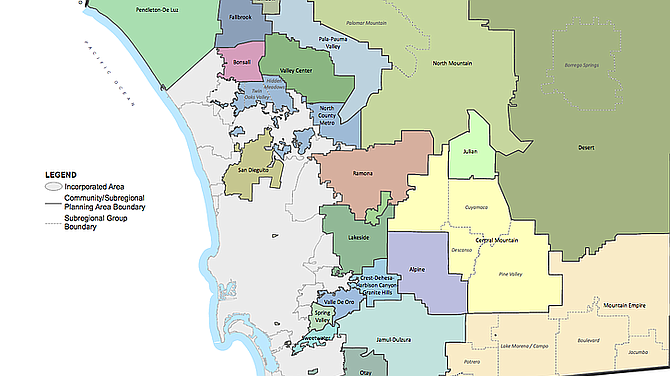
Option B would support infill in the unincorporated county and areas of its western edge.
Tomorrow, July 1, a new state law aimed at curbing vehicle emissions takes effect, and the county must change the way it reviews development impacts. Nowhere does it matter more than in the rural areas.
Last week, the county board of supervisors settled on one of three different options the planning department has mapped out to comply with SB 743, which encourages growth near city centers.
Speaker after speaker argued that only one of the alternatives actually meets the intent of the law: less driving. It wasn't the one staff recommended.
"This is really a shell of a program," said Dan Silver, executive director of the Endangered Habitats League. The methodology used would exempt a huge number of units from traffic analysis.
Noah Harris, transportation advocate for the Climate Action Campaign, said the county's recommended option would make it "much easier and more cost effective to develop sprawl than infill."
The county now reviews the traffic impacts of projects by focusing on congestion relief. Say, road widening. That approach can no longer be used, said Rami Talleh, deputy director of Planning & Development Services.
Instead of making way for traffic, the new goal is to reduce it.
The old "level of service" metric has been traded for "vehicle miles traveled" – a major switch the county must make in this first phase of planning changes.
Vehicle miles are how much extra auto travel a project will create. A 10-mile trip is 10 vehicle miles traveled. The average for an area is the total vehicle miles traveled divided by the population.
Planners recommended putting the options in a transportation study guide for use in preparing California Environmental Quality Act reviews.
One big part of the study guide are geographic boundaries, which set the size and location of unincorporated areas dubbed "vehicle miles traveled efficient." These are areas within the county that are already 15 percent below the average on auto trips – not having a significant impact.
That designation could exempt an area from the vehicle miles analysis. Only plans above 15 percent would have to do a study.
In a comment letter, Dan Silver said the county's proposal would screen out "vast amounts of vehicle miles traveled," which would never be mitigated due in part to the selected geography.
Option A was the entire county, 2.9 million acres, as a geographic boundary. Environmental groups preferred it. It places 2,467 acres of vehicle miles traveled efficient areas within the unincorporated county – areas in Lakeside, Via De Oro, North County metro and Borrego Springs.
It achieves the most greenhouse gas reductions, has the most environmental review, and requires the most mitigation. It offers the least support for infill in the unincorporated county, and the least benefit from alternative travel, such as walking and cycling – which some residents don't mind.
"Traffic mitigation of adding sidewalks and bike lanes are useless, if not impossible, in the backcountry," said Michael Casinelli, a member of the Jamul Dulzura Community Planning Group.
"You cannot add bike lanes on a two-lane road with no shoulders or mitigate traffic with sidewalks when large isolated developments are miles from the nearest business and employment centers."
Level of Service mitigation would still be needed to offset negative traffic impacts in the backcountry, he said. That is, adding traffic lanes, turn-pockets, and signals.
Option B was the unincorporated areas, 2.2 million acres, putting about 45,000 acres in vehicle miles traveled efficient areas. It would support infill in the unincorporated county and areas of its western edge.
Talleh said the county recommended it because it balances the goals of reducing emissions and infill development within villages. It encourages development in areas that could have alternative travel and puts vehicle miles traveled efficient areas closer to jobs and services.
It was the option the board chose, with supervisor Nathan Fletcher opposed. "There are areas in the unincorporated county where housing is simply not appropriate," he said, citing auto trips, emissions, and wildfire. He made a motion to adopt the recommended plan – but making the geographic basis option A.
Under B, a large number of General Plan compliant projects within villages along the western edge of the unincorporated boundary would not need a vehicle miles analysis.
Also in support of the option was the building industry.
Option C, based on five subareas within the unincorporated area, aligns with general plan goals to focus development within villages throughout the unincorporated area, Talleh said.
Each option meets the law's intent, according to county counsel.
Supervisor Diane Jacob asked if critics were right that under B, the unincorporated area, 3/4 of projects would really have no vehicle miles traveled analysis?
"That is accurate," Talleh said. Based upon the location of vehicle miles traveled efficient areas, it would consider about 30 percent of the General Plan capacity as "less than significant."
Here's something you might be interested in.
Forget bike lanes or sidewalks in rural San Diego County
Supervisors steer around anti-car measure
Forget bike lanes or sidewalks in rural San Diego County
Supervisors steer around anti-car measure
Option B would support infill in the unincorporated county and areas of its western edge.
Tomorrow, July 1, a new state law aimed at curbing vehicle emissions takes effect, and the county must change the way it reviews development impacts. Nowhere does it matter more than in the rural areas.
Last week, the county board of supervisors settled on one of three different options the planning department has mapped out to comply with SB 743, which encourages growth near city centers.
Speaker after speaker argued that only one of the alternatives actually meets the intent of the law: less driving. It wasn't the one staff recommended.
"This is really a shell of a program," said Dan Silver, executive director of the Endangered Habitats League. The methodology used would exempt a huge number of units from traffic analysis.
Noah Harris, transportation advocate for the Climate Action Campaign, said the county's recommended option would make it "much easier and more cost effective to develop sprawl than infill."
The county now reviews the traffic impacts of projects by focusing on congestion relief. Say, road widening. That approach can no longer be used, said Rami Talleh, deputy director of Planning & Development Services.
Instead of making way for traffic, the new goal is to reduce it.
The old "level of service" metric has been traded for "vehicle miles traveled" – a major switch the county must make in this first phase of planning changes.
Vehicle miles are how much extra auto travel a project will create. A 10-mile trip is 10 vehicle miles traveled. The average for an area is the total vehicle miles traveled divided by the population.
Planners recommended putting the options in a transportation study guide for use in preparing California Environmental Quality Act reviews.
One big part of the study guide are geographic boundaries, which set the size and location of unincorporated areas dubbed "vehicle miles traveled efficient." These are areas within the county that are already 15 percent below the average on auto trips – not having a significant impact.
That designation could exempt an area from the vehicle miles analysis. Only plans above 15 percent would have to do a study.
In a comment letter, Dan Silver said the county's proposal would screen out "vast amounts of vehicle miles traveled," which would never be mitigated due in part to the selected geography.
Option A was the entire county, 2.9 million acres, as a geographic boundary. Environmental groups preferred it. It places 2,467 acres of vehicle miles traveled efficient areas within the unincorporated county – areas in Lakeside, Via De Oro, North County metro and Borrego Springs.
It achieves the most greenhouse gas reductions, has the most environmental review, and requires the most mitigation. It offers the least support for infill in the unincorporated county, and the least benefit from alternative travel, such as walking and cycling – which some residents don't mind.
"Traffic mitigation of adding sidewalks and bike lanes are useless, if not impossible, in the backcountry," said Michael Casinelli, a member of the Jamul Dulzura Community Planning Group.
"You cannot add bike lanes on a two-lane road with no shoulders or mitigate traffic with sidewalks when large isolated developments are miles from the nearest business and employment centers."
Level of Service mitigation would still be needed to offset negative traffic impacts in the backcountry, he said. That is, adding traffic lanes, turn-pockets, and signals.
Option B was the unincorporated areas, 2.2 million acres, putting about 45,000 acres in vehicle miles traveled efficient areas. It would support infill in the unincorporated county and areas of its western edge.
Talleh said the county recommended it because it balances the goals of reducing emissions and infill development within villages. It encourages development in areas that could have alternative travel and puts vehicle miles traveled efficient areas closer to jobs and services.
It was the option the board chose, with supervisor Nathan Fletcher opposed. "There are areas in the unincorporated county where housing is simply not appropriate," he said, citing auto trips, emissions, and wildfire. He made a motion to adopt the recommended plan – but making the geographic basis option A.
Under B, a large number of General Plan compliant projects within villages along the western edge of the unincorporated boundary would not need a vehicle miles analysis.
Also in support of the option was the building industry.
Option C, based on five subareas within the unincorporated area, aligns with general plan goals to focus development within villages throughout the unincorporated area, Talleh said.
Each option meets the law's intent, according to county counsel.
Supervisor Diane Jacob asked if critics were right that under B, the unincorporated area, 3/4 of projects would really have no vehicle miles traveled analysis?
"That is accurate," Talleh said. Based upon the location of vehicle miles traveled efficient areas, it would consider about 30 percent of the General Plan capacity as "less than significant."
Commentsadventure256
This comment was removed by the site staff for violation of the usage agreement.
July 26, 2020