Here's something you might be interested in.
Ask a Hipster — Advice you didn't know you needed
Big Screen — Movie commentary
Blurt — Music's inside track
Booze News — San Diego spirits
Classical Music — Immortal beauty
Classifieds — Free and easy
Cover Stories — Front-page features
Drinks All Around — Bartenders' drink recipes
Excerpts — Literary and spiritual excerpts
Feast! — Food & drink reviews
Feature Stories — Local news & stories
Fishing Report — What’s getting hooked from ship and shore
From the Archives — Spotlight on the past
Golden Dreams — Talk of the town
The Gonzo Report — Making the musical scene, or at least reporting from it
Letters — Our inbox
Movies@Home — Local movie buffs share favorites
Movie Reviews — Our critics' picks and pans
Musician Interviews — Up close with local artists
Neighborhood News from Stringers — Hyperlocal news
News Ticker — News & politics
Obermeyer — San Diego politics illustrated
Outdoors — Weekly changes in flora and fauna
Overheard in San Diego — Eavesdropping illustrated
Poetry — The old and the new
Reader Travel — Travel section built by travelers
Reading — The hunt for intellectuals
Roam-O-Rama — SoCal's best hiking/biking trails
San Diego Beer — Inside San Diego suds
SD on the QT — Almost factual news
Sheep and Goats — Places of worship
Special Issues — The best of
Street Style — San Diego streets have style
Surf Diego — Real stories from those braving the waves
Theater — On stage in San Diego this week
Tin Fork — Silver spoon alternative
Under the Radar — Matt Potter's undercover work
Unforgettable — Long-ago San Diego
Unreal Estate — San Diego's priciest pads
Your Week — Daily event picks
The Del Mar Mesa Duck Pond: a reservoir behind an earthen dam
Is it possible that the Duck Farm once used duckweed from this pond to feed their ducks?
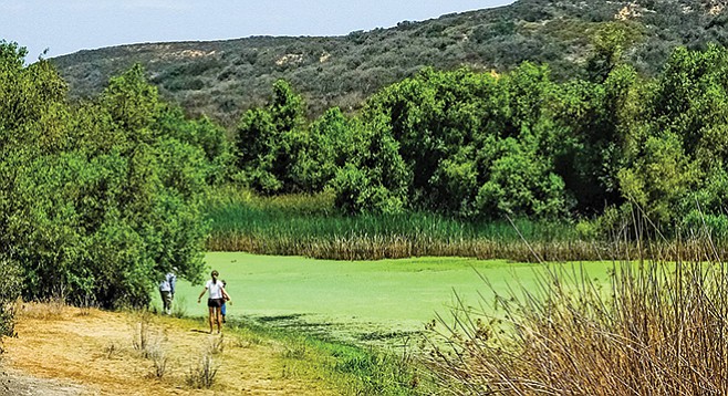
Visitors enjoy the duck pond
The route described here is one of the official City of San Diego Parks & Recreation trails. In addition, there are many unofficial trails through this same area that have been created by mountain bikers over the years. Some of these provide an alternative to the route described here, but occasionally these include an adrenaline rush that is best avoided by hikers and equestrians. For your safety and for the preservation of this unique habitat, please stay on the official trails.
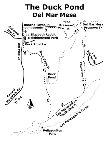
From the Elizabeth Rabbitt Trailhead, begin by hiking south on the Del Mar Mesa Trail, parallel to Del Vino Road. Soon you will see a sign for Duck Pond Lane. Ignore it, as it just leads to a small-gated community of 12 homes. Fifty yards south of this community’s entrance, a trail leads off to your left. Although not signed as such, this is the Duck Pond Trail, leading down a canyon, initially through a grove of eucalyptus trees, then through mixed chaparral habitat. Scrub oak (Quercus berberidifolia) is the most common chaparral species along the trail, but it is mixed with sugar bush, laurel sumac, and San Diego goldenbush.
As you continue south, you will begin to see riparian habitat on your left, with an abundance of arroyo willows, mule fat, a few large black willow trees, and occasional California sycamores. There is some poison oak near the trail as well.
At about 0.62 mile from the trailhead, the Duck Pond appears on your left. It is a reservoir behind an earthen dam, impounding the intermittent creek you have been following. The Duck Pond is a remnant of the days when cattle roamed these hills, but is now home to ducks and a verdant bloom of duckweed (Lemna minor).
Duckweeds are free-floating aquatic plants that grow rapidly in still waters, such as in this pond. It is one of the world’s smallest flowering plants. It has no stem and is composed of one to four tiny leaves, each of which has a root. It rarely flowers, and you would need a good dissecting microscope to see a Lemna flower; even in full bloom, they are only about 1 mm long. These days, duckweed is extensively used for bioremediation, because this little plant removes toxic heavy metals from water and the plant is easily removed after the job is done. It is also grown commercially as animal food, especially for chickens and ducks. Is it possible that the Duck Farm once used duckweed from this pond to feed their ducks?
For the out-and-back hike, this is where you turn around and go back to your vehicle the way you came to complete your hike. To complete the loop hike, continue south on the Duck Pond Trail for another 0.4 mile where it joins the Los Peñasquitos North Side Trail. You will be close to Peñasquitos Falls when you reach this point. If you have time for a worthwhile diversion, look for the sign pointing the way and take some time to enjoy the sound and sight of falling water.
To continue the loop hike, go east on the broad, heavily traveled Peñasquitos Trail when you reach it. The habitat here is open grassland, with a few scattered California buckwheat shrubs. Looking off to your right, you will see the tall, dense, riparian forest through which Los Peñasquitos Creek flows, but you are some distance from it. Continue east on the Peñasquitos Trail for about 0.4 mile to where you see the Powerline Trail going north east up a canyon. Actually, this trail is a service road for the SDG&E’s power line, but is also is a San Diego City recreational trail.
As you hike up the Powerline Trail, notice the abundance of large scrub oaks on either side of you. Two of the three types of lichens (foliose, crustose, and fruticose) are found here encasing the trunks. Foliose lichens typically have broad lobes, while crustose lichens have less surface area and grow more slowly. The colors vary and the patterns can be intricate and beautiful for these symbiotic plants that are a cooperating combination of algae and fungus, the one providing food and the other attachment to the tree trunk. Also look at the smaller branches that may be decorated with orange oak galls. Note that most of these oaks are multi-trunked with a thicket of smaller branches protruding from them. The larger trees are nearly 20 feet tall. If you could remove the thicket of lower branches, you could walk under these scrub oak trees. A grizzly bear could easily force it way through these lower branches, creating a tunnel through the chaparral, as bears were believed to have done before they were exterminated. These grizzly-made tunnels probably were much like the chaparral tunnels hikers now travel through in the Del Mar Mesa Preserve.
At about 2.3 miles from the trailhead, the Powerline Trail joins Del Mar Mesa Preserve Trail. Going right at the junction will take you through chaparral Tunnel 4, a hike described elsewhere in this series (Del Mar Mesa Preserve 6-27-18). To complete the Duck Pond loop hike, go left at the junction. Follow the trail around a small housing development named “The Preserve” until you reach Rancho Toyon Place. The trail is now parallel to the road. Follow it west until you reach Del Vino Court, then turn left (south) on the Del Mar Mesa Trail and follow it to the Neighborhood Park and your vehicle.
(The controversy over the naming of the park stems from the fact that the Del Mar Mesa Community Planning Board was excluded from naming the park. It was officially named for Elizabeth S. Rabbitt, the former CEO of Sharp Medical Group and a pioneer in the development of the Del Mar Mesa Community. The Planning Board contends that it is inappropriate to single out one person when the development of the park was a community effort and that it should be named for the community.)
The Duck Pond, Del Mar Mesa
Experience dense stands of lichen-encrusted scrub oaks.
Duck Pond Del Mar Mesa map
Driving directions: (Del Mar) From I-5 north, stay in the right lane as you approach the I-5 /I-805 merge and get on the I-5 local Bypass road. Exit the I-5 Bypass road onto Carmel Mountain Road. Follow Carmel Mountain Road east through one signal, turning right at the next, the continuation of Carmel Mountain Road. In about 5 miles, its name changes to Del Vino Road. Continue east on Del Vino Road until you reach Elizabeth Rabbitt Neighborhood Park (a San Diego City Park, possibly renamed “Del Mar Mesa Neighborhood Park” by the time you read this). The trailhead for this hike is on your right. Hiking length: two options, either a 1.2-mile out-and-back—allow 1 hour hiking time, or a 3.4-mile loop—allow 2 hours hiking time. Difficulty: Easy with elevation gain/loss of 200 feet, or moderate with elevation gain/loss of 400 feet. Facilities and drinking water are available here, as well as designated auto and horse parking, picnic tables, and a children’s play area. The trail is open from sunrise to sunset for hikers, with or without leashed dogs, mountain bikers without power assists, and equestrians. The trail is interesting year around, but it is best in late winter and spring for wildflowers, particularly following a season with average or abundant rainfall. The out-and-back hike is a particularly good one for families with small children.
Here's something you might be interested in.
The Del Mar Mesa Duck Pond: a reservoir behind an earthen dam
Is it possible that the Duck Farm once used duckweed from this pond to feed their ducks?
The Del Mar Mesa Duck Pond: a reservoir behind an earthen dam
Is it possible that the Duck Farm once used duckweed from this pond to feed their ducks?
Visitors enjoy the duck pond
The route described here is one of the official City of San Diego Parks & Recreation trails. In addition, there are many unofficial trails through this same area that have been created by mountain bikers over the years. Some of these provide an alternative to the route described here, but occasionally these include an adrenaline rush that is best avoided by hikers and equestrians. For your safety and for the preservation of this unique habitat, please stay on the official trails.
From the Elizabeth Rabbitt Trailhead, begin by hiking south on the Del Mar Mesa Trail, parallel to Del Vino Road. Soon you will see a sign for Duck Pond Lane. Ignore it, as it just leads to a small-gated community of 12 homes. Fifty yards south of this community’s entrance, a trail leads off to your left. Although not signed as such, this is the Duck Pond Trail, leading down a canyon, initially through a grove of eucalyptus trees, then through mixed chaparral habitat. Scrub oak (Quercus berberidifolia) is the most common chaparral species along the trail, but it is mixed with sugar bush, laurel sumac, and San Diego goldenbush.
As you continue south, you will begin to see riparian habitat on your left, with an abundance of arroyo willows, mule fat, a few large black willow trees, and occasional California sycamores. There is some poison oak near the trail as well.
At about 0.62 mile from the trailhead, the Duck Pond appears on your left. It is a reservoir behind an earthen dam, impounding the intermittent creek you have been following. The Duck Pond is a remnant of the days when cattle roamed these hills, but is now home to ducks and a verdant bloom of duckweed (Lemna minor).
Duckweeds are free-floating aquatic plants that grow rapidly in still waters, such as in this pond. It is one of the world’s smallest flowering plants. It has no stem and is composed of one to four tiny leaves, each of which has a root. It rarely flowers, and you would need a good dissecting microscope to see a Lemna flower; even in full bloom, they are only about 1 mm long. These days, duckweed is extensively used for bioremediation, because this little plant removes toxic heavy metals from water and the plant is easily removed after the job is done. It is also grown commercially as animal food, especially for chickens and ducks. Is it possible that the Duck Farm once used duckweed from this pond to feed their ducks?
For the out-and-back hike, this is where you turn around and go back to your vehicle the way you came to complete your hike. To complete the loop hike, continue south on the Duck Pond Trail for another 0.4 mile where it joins the Los Peñasquitos North Side Trail. You will be close to Peñasquitos Falls when you reach this point. If you have time for a worthwhile diversion, look for the sign pointing the way and take some time to enjoy the sound and sight of falling water.
To continue the loop hike, go east on the broad, heavily traveled Peñasquitos Trail when you reach it. The habitat here is open grassland, with a few scattered California buckwheat shrubs. Looking off to your right, you will see the tall, dense, riparian forest through which Los Peñasquitos Creek flows, but you are some distance from it. Continue east on the Peñasquitos Trail for about 0.4 mile to where you see the Powerline Trail going north east up a canyon. Actually, this trail is a service road for the SDG&E’s power line, but is also is a San Diego City recreational trail.
As you hike up the Powerline Trail, notice the abundance of large scrub oaks on either side of you. Two of the three types of lichens (foliose, crustose, and fruticose) are found here encasing the trunks. Foliose lichens typically have broad lobes, while crustose lichens have less surface area and grow more slowly. The colors vary and the patterns can be intricate and beautiful for these symbiotic plants that are a cooperating combination of algae and fungus, the one providing food and the other attachment to the tree trunk. Also look at the smaller branches that may be decorated with orange oak galls. Note that most of these oaks are multi-trunked with a thicket of smaller branches protruding from them. The larger trees are nearly 20 feet tall. If you could remove the thicket of lower branches, you could walk under these scrub oak trees. A grizzly bear could easily force it way through these lower branches, creating a tunnel through the chaparral, as bears were believed to have done before they were exterminated. These grizzly-made tunnels probably were much like the chaparral tunnels hikers now travel through in the Del Mar Mesa Preserve.
At about 2.3 miles from the trailhead, the Powerline Trail joins Del Mar Mesa Preserve Trail. Going right at the junction will take you through chaparral Tunnel 4, a hike described elsewhere in this series (Del Mar Mesa Preserve 6-27-18). To complete the Duck Pond loop hike, go left at the junction. Follow the trail around a small housing development named “The Preserve” until you reach Rancho Toyon Place. The trail is now parallel to the road. Follow it west until you reach Del Vino Court, then turn left (south) on the Del Mar Mesa Trail and follow it to the Neighborhood Park and your vehicle.
(The controversy over the naming of the park stems from the fact that the Del Mar Mesa Community Planning Board was excluded from naming the park. It was officially named for Elizabeth S. Rabbitt, the former CEO of Sharp Medical Group and a pioneer in the development of the Del Mar Mesa Community. The Planning Board contends that it is inappropriate to single out one person when the development of the park was a community effort and that it should be named for the community.)
The Duck Pond, Del Mar Mesa
Experience dense stands of lichen-encrusted scrub oaks.
Duck Pond Del Mar Mesa map
Driving directions: (Del Mar) From I-5 north, stay in the right lane as you approach the I-5 /I-805 merge and get on the I-5 local Bypass road. Exit the I-5 Bypass road onto Carmel Mountain Road. Follow Carmel Mountain Road east through one signal, turning right at the next, the continuation of Carmel Mountain Road. In about 5 miles, its name changes to Del Vino Road. Continue east on Del Vino Road until you reach Elizabeth Rabbitt Neighborhood Park (a San Diego City Park, possibly renamed “Del Mar Mesa Neighborhood Park” by the time you read this). The trailhead for this hike is on your right. Hiking length: two options, either a 1.2-mile out-and-back—allow 1 hour hiking time, or a 3.4-mile loop—allow 2 hours hiking time. Difficulty: Easy with elevation gain/loss of 200 feet, or moderate with elevation gain/loss of 400 feet. Facilities and drinking water are available here, as well as designated auto and horse parking, picnic tables, and a children’s play area. The trail is open from sunrise to sunset for hikers, with or without leashed dogs, mountain bikers without power assists, and equestrians. The trail is interesting year around, but it is best in late winter and spring for wildflowers, particularly following a season with average or abundant rainfall. The out-and-back hike is a particularly good one for families with small children.
Comments