Here's something you might be interested in.
Ask a Hipster — Advice you didn't know you needed
Big Screen — Movie commentary
Blurt — Music's inside track
Booze News — San Diego spirits
Classical Music — Immortal beauty
Classifieds — Free and easy
Close to Home — What it’s like on the street where you live
Cover Stories — Front-page features
Drinks All Around — Bartenders' drink recipes
Excerpts — Literary and spiritual excerpts
Feast! — Food & drink reviews
Feature Stories — Local news & stories
Fishing Report — What’s getting hooked from ship and shore
From the Archives — Spotlight on the past
Golden Dreams — Talk of the town
The Gonzo Report — Making the musical scene, or at least reporting from it
Letters — Our inbox
Movies@Home — Local movie buffs share favorites
Movie Reviews — Our critics' picks and pans
Musician Interviews — Up close with local artists
Neighborhood News from Stringers — Hyperlocal news
News Ticker — News & politics
Obermeyer — San Diego politics illustrated
Outdoors — Weekly changes in flora and fauna
Overheard in San Diego — Eavesdropping illustrated
Poetry — The old and the new
Reader Travel — Travel section built by travelers
Reading — The hunt for intellectuals
Roam-O-Rama — SoCal's best hiking/biking trails
San Diego Beer — Inside San Diego suds
SD on the QT — Almost factual news
Sheep and Goats — Places of worship
Special Issues — The best of
Street Style — San Diego streets have style
Surf Diego — Real stories from those braving the waves
Theater — On stage in San Diego this week
Tin Fork — Silver spoon alternative
Under the Radar — Matt Potter's undercover work
Unforgettable — Long-ago San Diego
Unreal Estate — San Diego's priciest pads
Your Week — Daily event picks
Potential canyon development in South Park
What about the neighbors? What about the sensitive habitat?
On January 9, the City of San Diego’s Development Services Department issued a notice of site development at the corner of Granada Avenue and Fir Street in South Park. Within days, dozens of nearby residents formed the Protect the 28th Street Canyon Coalition to formally object to the developer's proposals on the basis it would disrupt a sensitive canyon habitat and impede a popular hiking trail.
Though a number of neighbors stand to lose canyon views and access if the project proceeds, they would have little recourse except for one fact: the developer of the property wants to build a significant portion of it on city land.
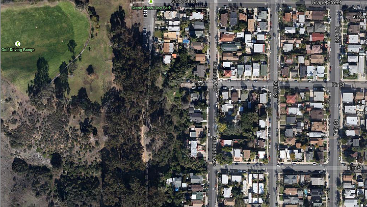
Specifically, the developer has filed an application with the city to vacate the easement currently held where 28th Street would connect between Fir and Elm. By vacating the easement, an additional 14,000 square feet of land — the eastern half of the easement — would revert to private property immediately adjacent; in this case, the 26,000-square-foot parcel held by the developer making the application.
Currently, 28th Street dead-ends at Golf Course Drive to the south, then picks up briefly to provide access to several homes and a parking lot for the dog park at Grape Street, before ending again south of Hawthorne and on through Switzer Canyon. While the city has held this easement since 1886, steep natural canyons running the length of this section have prevented any improvement, leaving it as a "paper street," visible on maps but neither paved nor developed.
The developer's plans would extend current the portion of 28th running south from Grape to provide access to four single-family homes that would be built into the canyon, partially on top of the reverted easement property. Additionally, the developer, identified as SDPB Holdings, has requested the vacation of an easement at the end of Fir Street, which would be used in part to build a fifth home on the eastern edge of the canyon.
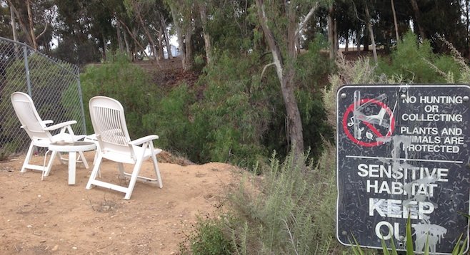
Meanwhile, signs erected at the dead end of Fir and Elm streets declare the area to be "Sensitive Habitat." However, the signs do not refer to any local government agency or organization, and local residents have no knowledge who declared the area sensitive or why. Calls to several relevant city departments and nonprofit conservation groups shed no light on how the signs came to be put here, though by all accounts they have been in place for years.
A representative from Development Services noted that, if more than 25 percent of the land in question exists on steep canyon slope, it may qualify under city guidelines as "Environmentally Sensitive." He says while he's already received approximately 40 phone calls objecting to the development, and about as many emails, objections may be premature, as the city has not yet had the opportunity to formally evaluate the proposal.
Nevertheless, the neighborhood opposition is well under way. Eric Bowlby, executive director of the nonprofit San Diego Canyon Lands, has joined forces, saying efforts to preserve the natural space may also have merit based on public use. Specifically, that residents consistently use it as a hiking trail connecting from the 28th Street Park to the trails of Switzer Canyon, which he calls "a really important asset to the citizens of North Park and South Park."
In order for the vacation of easements to be approved, the application must first be evaluated by the Greater Golden Hill Planning Committee, which will hold a public referendum on the matter, tentatively scheduled for March 12 at 6:30 p.m. at the Balboa Park Golf Clubhouse. Their recommendation will then be submitted to Development Services for advisement, but the vacation of easements must ultimately be approved by the city council.
The listed developer contact is an employee of the PQ Design Studio in Miramar, headed by Phil Quatrino. The application to the city was submitted by Michael Donovan on behalf of SDPB Holdings, LLC. Neither wished to comment at this time.
Here's something you might be interested in.
Potential canyon development in South Park
What about the neighbors? What about the sensitive habitat?
Potential canyon development in South Park
What about the neighbors? What about the sensitive habitat?
On January 9, the City of San Diego’s Development Services Department issued a notice of site development at the corner of Granada Avenue and Fir Street in South Park. Within days, dozens of nearby residents formed the Protect the 28th Street Canyon Coalition to formally object to the developer's proposals on the basis it would disrupt a sensitive canyon habitat and impede a popular hiking trail.
Though a number of neighbors stand to lose canyon views and access if the project proceeds, they would have little recourse except for one fact: the developer of the property wants to build a significant portion of it on city land.
Specifically, the developer has filed an application with the city to vacate the easement currently held where 28th Street would connect between Fir and Elm. By vacating the easement, an additional 14,000 square feet of land — the eastern half of the easement — would revert to private property immediately adjacent; in this case, the 26,000-square-foot parcel held by the developer making the application.
Currently, 28th Street dead-ends at Golf Course Drive to the south, then picks up briefly to provide access to several homes and a parking lot for the dog park at Grape Street, before ending again south of Hawthorne and on through Switzer Canyon. While the city has held this easement since 1886, steep natural canyons running the length of this section have prevented any improvement, leaving it as a "paper street," visible on maps but neither paved nor developed.
The developer's plans would extend current the portion of 28th running south from Grape to provide access to four single-family homes that would be built into the canyon, partially on top of the reverted easement property. Additionally, the developer, identified as SDPB Holdings, has requested the vacation of an easement at the end of Fir Street, which would be used in part to build a fifth home on the eastern edge of the canyon.
Meanwhile, signs erected at the dead end of Fir and Elm streets declare the area to be "Sensitive Habitat." However, the signs do not refer to any local government agency or organization, and local residents have no knowledge who declared the area sensitive or why. Calls to several relevant city departments and nonprofit conservation groups shed no light on how the signs came to be put here, though by all accounts they have been in place for years.
A representative from Development Services noted that, if more than 25 percent of the land in question exists on steep canyon slope, it may qualify under city guidelines as "Environmentally Sensitive." He says while he's already received approximately 40 phone calls objecting to the development, and about as many emails, objections may be premature, as the city has not yet had the opportunity to formally evaluate the proposal.
Nevertheless, the neighborhood opposition is well under way. Eric Bowlby, executive director of the nonprofit San Diego Canyon Lands, has joined forces, saying efforts to preserve the natural space may also have merit based on public use. Specifically, that residents consistently use it as a hiking trail connecting from the 28th Street Park to the trails of Switzer Canyon, which he calls "a really important asset to the citizens of North Park and South Park."
In order for the vacation of easements to be approved, the application must first be evaluated by the Greater Golden Hill Planning Committee, which will hold a public referendum on the matter, tentatively scheduled for March 12 at 6:30 p.m. at the Balboa Park Golf Clubhouse. Their recommendation will then be submitted to Development Services for advisement, but the vacation of easements must ultimately be approved by the city council.
The listed developer contact is an employee of the PQ Design Studio in Miramar, headed by Phil Quatrino. The application to the city was submitted by Michael Donovan on behalf of SDPB Holdings, LLC. Neither wished to comment at this time.
Comments