Here's something you might be interested in.
Ask a Hipster — Advice you didn't know you needed
Big Screen — Movie commentary
Blurt — Music's inside track
Booze News — San Diego spirits
Classical Music — Immortal beauty
Classifieds — Free and easy
Cover Stories — Front-page features
Drinks All Around — Bartenders' drink recipes
Excerpts — Literary and spiritual excerpts
Feast! — Food & drink reviews
Feature Stories — Local news & stories
Fishing Report — What’s getting hooked from ship and shore
From the Archives — Spotlight on the past
Golden Dreams — Talk of the town
The Gonzo Report — Making the musical scene, or at least reporting from it
Letters — Our inbox
Movies@Home — Local movie buffs share favorites
Movie Reviews — Our critics' picks and pans
Musician Interviews — Up close with local artists
Neighborhood News from Stringers — Hyperlocal news
News Ticker — News & politics
Obermeyer — San Diego politics illustrated
Outdoors — Weekly changes in flora and fauna
Overheard in San Diego — Eavesdropping illustrated
Poetry — The old and the new
Reader Travel — Travel section built by travelers
Reading — The hunt for intellectuals
Roam-O-Rama — SoCal's best hiking/biking trails
San Diego Beer — Inside San Diego suds
SD on the QT — Almost factual news
Sheep and Goats — Places of worship
Special Issues — The best of
Street Style — San Diego streets have style
Surf Diego — Real stories from those braving the waves
Theater — On stage in San Diego this week
Tin Fork — Silver spoon alternative
Under the Radar — Matt Potter's undercover work
Unforgettable — Long-ago San Diego
Unreal Estate — San Diego's priciest pads
Your Week — Daily event picks
New Zealand’s otherworldly Tongariro Crossing
The 12-mile volcanic trail is heralded as one of the country's best.

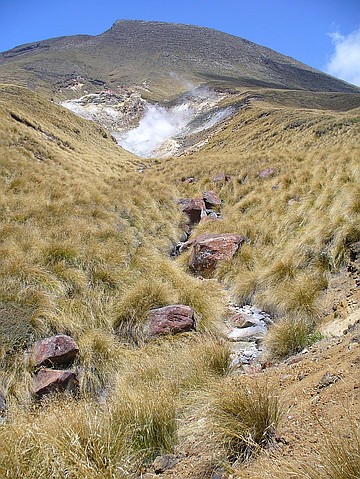
Hiking one of New Zealand's top treks. Mt. Ngauruhoe rises above lava remains in the foreground.
I have a mix of fear and respect for volcanoes. They are imposing, difficult to climb, and can erupt with little warning. However, when my husband and I visited New Zealand, our friends strongly recommended trekking amongst the volcanoes on the Tongariro Alpine Crossing, arguably the country’s most spectacular one-day nature walk.
The way up
It was an early morning start around 7:30 a.m. when we got a first view of the narrow path, lined with marker poles across an open, treeless plain of red tussock and small shrubs. While the trail can be traveled in both directions, most hikers begin here as the other trailhead at Ketetahi adds an extra hour of inclined walking.
Steam vents along the trail.
Despite being far from civilization, we were not alone. The famed route was busy on this summer morning. We set off with what seemed like another 100 hikers. Thankfully, our varied strides quickly spaced us out along the trail.
The wind blew softly, the sun was shining, and broom heath blossomed everywhere. Before long, we reached Soda Springs and a long queue announced the last toilet facilities before the end of the crossing (being above the tree line makes discrete outdoor bathroom breaks rather difficult).
Beyond here the trail climbed out of the valley directly up the volcano’s steep face. The leisurely stroll had ended abruptly because of what confronted us – the justly named Devil’s Staircase. This only partially fortified section of the trail involves climbing from 4,593 feet to 5,249 feet on a trail of old lava flow, rough basalt and plated steps. It was murder on the muscles and joints, and soon I was exhausted.
“Come on, just to the next pole,” my husband encouraged me.
At the summit
When we reached the summit, the view of the valley below and out across the surrounding countryside was worth every aching muscle. In the far distance looking back, I could make out a line of people approaching the incline, while Mt. Ngauruhoe (7,516 feet) rose majestically to my right. At the end of the nearly one-hour climb, we reached South Crater.
South Crater looked like some strange land from a Star Trek episode.
Its surface is yellow with scattered small rocks and barely any vegetation in sight. Ahead of us was already the next ascent to Red Crater, a disturbingly primordial rift of dark red and charcoal grey.
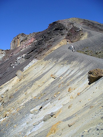
Heading down from Red Crater.
it wasn't quite as strenuous as the Devils Staircase, and we quickly reached the highest point of the crossing (6,188 feet). Sitting down despite the wind chill (I had put some gloves on by now), we were surrounded by spectacular views. Mt. Ngauruhoe stood imposingly behind the crater, while the even larger snow-capped Mt. Ruapehu dominated the sky behind it.
Emerald Lakes
Looking ahead of us, we could see the famed Emerald Lakes. The descent from Red Crater (left) invited haste as the mesmerizing trio of turquoise and emerald-colored lakes promised a photo opportunity and welcome resting spot, but it was dangerous as loose ash and sand kept shifting and sliding beneath our feet.

Emerald Lakes overlook from the trail.
After 30 minutes, we arrived at the lakes whose vibrant colors stem from minerals released from the surrounding rock. Clouds of steam vented from the earth with a pungent stench of sulfur revealing its volcanic source.
Despite the smell, the scenery was too beautiful to give it a second thought.
We continued walking across the open plane – Central Crater, before arriving near the wide, round Blue Lake. The lake is Tapu for Maori and it’s considered disrespectful to eat or drink around its shores.
The route back down
A short easy climb led us to the edge of North Crater which was once filled with molten lava, then cooled and solidified to give a level surface more than 3,300 ft wide. The following zigzagging walk led us down to Ketetahi Hut where we had a quick snack, and shed our warm clothing now that we had descended back into summer.
For the last two hours the downhill trail led us adjacent to a stream, and minerals had visibly stained the rocks. Next to the walkway, hot steam erupted in plumes at various spots and signs warned to stay on the path.
Soon we noticed the first traces of vegetation. Small scrubs and flowers turned into a rainforest with native trees, ferns and birds as we submerged back below the tree line. The shade was a welcome change from the hot sun, and the water reminded us that we were close to the end of our 12-mile walk.
We arrived a full hour before the agreed pick-up time for our return transfer, and I regretted for a small moment not having spent more time at Red Crater or the Emerald Lakes. However, the feeling of exhaustion gave way to a humble sense of accomplishment of having “conquered” the Tongariro Alpine Crossing.
Here's something you might be interested in.
New Zealand’s otherworldly Tongariro Crossing
The 12-mile volcanic trail is heralded as one of the country's best.
New Zealand’s otherworldly Tongariro Crossing
The 12-mile volcanic trail is heralded as one of the country's best.
Hiking one of New Zealand's top treks. Mt. Ngauruhoe rises above lava remains in the foreground.
I have a mix of fear and respect for volcanoes. They are imposing, difficult to climb, and can erupt with little warning. However, when my husband and I visited New Zealand, our friends strongly recommended trekking amongst the volcanoes on the Tongariro Alpine Crossing, arguably the country’s most spectacular one-day nature walk.
The way up
It was an early morning start around 7:30 a.m. when we got a first view of the narrow path, lined with marker poles across an open, treeless plain of red tussock and small shrubs. While the trail can be traveled in both directions, most hikers begin here as the other trailhead at Ketetahi adds an extra hour of inclined walking.
Steam vents along the trail.
Despite being far from civilization, we were not alone. The famed route was busy on this summer morning. We set off with what seemed like another 100 hikers. Thankfully, our varied strides quickly spaced us out along the trail.
The wind blew softly, the sun was shining, and broom heath blossomed everywhere. Before long, we reached Soda Springs and a long queue announced the last toilet facilities before the end of the crossing (being above the tree line makes discrete outdoor bathroom breaks rather difficult).
Beyond here the trail climbed out of the valley directly up the volcano’s steep face. The leisurely stroll had ended abruptly because of what confronted us – the justly named Devil’s Staircase. This only partially fortified section of the trail involves climbing from 4,593 feet to 5,249 feet on a trail of old lava flow, rough basalt and plated steps. It was murder on the muscles and joints, and soon I was exhausted.
“Come on, just to the next pole,” my husband encouraged me.
At the summit
When we reached the summit, the view of the valley below and out across the surrounding countryside was worth every aching muscle. In the far distance looking back, I could make out a line of people approaching the incline, while Mt. Ngauruhoe (7,516 feet) rose majestically to my right. At the end of the nearly one-hour climb, we reached South Crater.
South Crater looked like some strange land from a Star Trek episode.
Its surface is yellow with scattered small rocks and barely any vegetation in sight. Ahead of us was already the next ascent to Red Crater, a disturbingly primordial rift of dark red and charcoal grey.
Heading down from Red Crater.
it wasn't quite as strenuous as the Devils Staircase, and we quickly reached the highest point of the crossing (6,188 feet). Sitting down despite the wind chill (I had put some gloves on by now), we were surrounded by spectacular views. Mt. Ngauruhoe stood imposingly behind the crater, while the even larger snow-capped Mt. Ruapehu dominated the sky behind it.
Emerald Lakes
Looking ahead of us, we could see the famed Emerald Lakes. The descent from Red Crater (left) invited haste as the mesmerizing trio of turquoise and emerald-colored lakes promised a photo opportunity and welcome resting spot, but it was dangerous as loose ash and sand kept shifting and sliding beneath our feet.
Emerald Lakes overlook from the trail.
After 30 minutes, we arrived at the lakes whose vibrant colors stem from minerals released from the surrounding rock. Clouds of steam vented from the earth with a pungent stench of sulfur revealing its volcanic source.
Despite the smell, the scenery was too beautiful to give it a second thought.
We continued walking across the open plane – Central Crater, before arriving near the wide, round Blue Lake. The lake is Tapu for Maori and it’s considered disrespectful to eat or drink around its shores.
The route back down
A short easy climb led us to the edge of North Crater which was once filled with molten lava, then cooled and solidified to give a level surface more than 3,300 ft wide. The following zigzagging walk led us down to Ketetahi Hut where we had a quick snack, and shed our warm clothing now that we had descended back into summer.
For the last two hours the downhill trail led us adjacent to a stream, and minerals had visibly stained the rocks. Next to the walkway, hot steam erupted in plumes at various spots and signs warned to stay on the path.
Soon we noticed the first traces of vegetation. Small scrubs and flowers turned into a rainforest with native trees, ferns and birds as we submerged back below the tree line. The shade was a welcome change from the hot sun, and the water reminded us that we were close to the end of our 12-mile walk.
We arrived a full hour before the agreed pick-up time for our return transfer, and I regretted for a small moment not having spent more time at Red Crater or the Emerald Lakes. However, the feeling of exhaustion gave way to a humble sense of accomplishment of having “conquered” the Tongariro Alpine Crossing.
Comments