Here's something you might be interested in.
Ask a Hipster — Advice you didn't know you needed
Big Screen — Movie commentary
Blurt — Music's inside track
Booze News — San Diego spirits
Classical Music — Immortal beauty
Classifieds — Free and easy
Close to Home — What it’s like on the street where you live
Cover Stories — Front-page features
Drinks All Around — Bartenders' drink recipes
Excerpts — Literary and spiritual excerpts
Feast! — Food & drink reviews
Feature Stories — Local news & stories
Fishing Report — What’s getting hooked from ship and shore
From the Archives — Spotlight on the past
Golden Dreams — Talk of the town
The Gonzo Report — Making the musical scene, or at least reporting from it
Letters — Our inbox
Movies@Home — Local movie buffs share favorites
Movie Reviews — Our critics' picks and pans
Musician Interviews — Up close with local artists
Neighborhood News from Stringers — Hyperlocal news
News Ticker — News & politics
Obermeyer — San Diego politics illustrated
Outdoors — Weekly changes in flora and fauna
Overheard in San Diego — Eavesdropping illustrated
Poetry — The old and the new
Reader Travel — Travel section built by travelers
Reading — The hunt for intellectuals
Roam-O-Rama — SoCal's best hiking/biking trails
San Diego Beer — Inside San Diego suds
SD on the QT — Almost factual news
Sheep and Goats — Places of worship
Special Issues — The best of
Street Style — San Diego streets have style
Surf Diego — Real stories from those braving the waves
Theater — On stage in San Diego this week
Tin Fork — Silver spoon alternative
Under the Radar — Matt Potter's undercover work
Unforgettable — Long-ago San Diego
Unreal Estate — San Diego's priciest pads
Your Week — Daily event picks
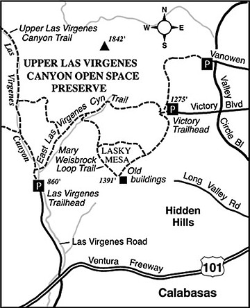
Victory to Las Virgenes
The Upper Las Virgenes Open Space Preserve (former Ahmanson Ranch) in the Simi Hills contains some great examples of oak-studded hilly terrain symbolic of coastal California. Right now these hills have lost their green sheen, and golden wild oats and other grasses carpet the spaces between the trees. Furthermore, the summer sun’s furnace breath at midday makes hiking or biking here not very desirable. Early or late in the day, though, it’s a different story. Cool air hunkers down in the long shadows cast by the high ridges, and refreshing breezes stir.
Summer mornings or evenings can be fine times for an easy, 2.8-mile, one-way traverse across the middle of the preserve — made possible by someone willing to drop you off at one trailhead (Victory Boulevard) and later pick you up at another trailhead (Las Virgenes Road). This east-to-west direction is preferred, since you gain only 50 feet of elevation and enjoy a steady loss of 450 feet of elevation along the way.
With that plan in mind, start at the Victory trailhead, which lies at the westernmost end of Victory Boulevard (a major San Fernando Valley thoroughfare), north and west of Highway 101 at Valley Circle Boulevard. Some 60 to 90 minutes walking time later, you’ll arrive at the Las Virgenes trailhead, at the northernmost end of Las Virgenes Road, 1.4 miles north of Highway 101. Mountain biking is allowed on the Victory-to-Las Virgenes route, and rapid travel by that method could actually beat your chase vehicle’s travel time between the two ends. The driving distance from one trailhead to the other measures eight miles by way of Victory Boulevard, Valley Circle Boulevard, Highway 101, and Las Virgenes Road.
From the Victory Trailhead, descend 0.1 mile to a trail junction and veer right. You’re on the East Las Virgenes Canyon Trail, which twists and turns a bit as it swoops into a shallow, tributary of Las Virgenes Canyon. You’re also on the signed Juan Bautista de Anza National Historical Trail, which rather closely traces the famed overland route of the 1775–76 Spanish expedition. On that expedition, some 30 families traveled from southern Arizona into California. Most settled in the San Francisco Bay Area.
On your gradually descending route, stay on the East Las Virgenes Canyon Trail as two other trails intersect on the left and the right. Enjoy the spacious vistas of wide-open grassland, highlighted here and there by valley and live oaks, willows, and sycamores. The scene is most impressive when the sun is low, and long shadows drape across the landscape.
After traveling for a total of 2.5 miles you arrive at the “confluence” of Las Virgenes Canyon’s east and main branches. Turn left there on the Upper Las Virgenes Canyon Trail and complete the remaining short distance over to the Las Virgenes Trailhead.
This article contains information about a publicly owned recreation or wilderness area. Trails and pathways are not necessarily marked. Conditions can change rapidly. Hikers should be properly equipped and have safety and navigational skills. The Reader and Jerry Schad assume no responsibility for any adverse experience.
VICTORY TO LAS VIRGENES
Follow an easy point-to-point route through the rolling Simi Hills west of the San Fernando Valley.
Distance from downtown San Diego: 145 miles
Hiking/biking length: 2.8 miles
Difficulty: Easy
Here's something you might be interested in.
Victory to Las Virgenes
Victory to Las Virgenes
The Upper Las Virgenes Open Space Preserve (former Ahmanson Ranch) in the Simi Hills contains some great examples of oak-studded hilly terrain symbolic of coastal California. Right now these hills have lost their green sheen, and golden wild oats and other grasses carpet the spaces between the trees. Furthermore, the summer sun’s furnace breath at midday makes hiking or biking here not very desirable. Early or late in the day, though, it’s a different story. Cool air hunkers down in the long shadows cast by the high ridges, and refreshing breezes stir.
Summer mornings or evenings can be fine times for an easy, 2.8-mile, one-way traverse across the middle of the preserve — made possible by someone willing to drop you off at one trailhead (Victory Boulevard) and later pick you up at another trailhead (Las Virgenes Road). This east-to-west direction is preferred, since you gain only 50 feet of elevation and enjoy a steady loss of 450 feet of elevation along the way.
With that plan in mind, start at the Victory trailhead, which lies at the westernmost end of Victory Boulevard (a major San Fernando Valley thoroughfare), north and west of Highway 101 at Valley Circle Boulevard. Some 60 to 90 minutes walking time later, you’ll arrive at the Las Virgenes trailhead, at the northernmost end of Las Virgenes Road, 1.4 miles north of Highway 101. Mountain biking is allowed on the Victory-to-Las Virgenes route, and rapid travel by that method could actually beat your chase vehicle’s travel time between the two ends. The driving distance from one trailhead to the other measures eight miles by way of Victory Boulevard, Valley Circle Boulevard, Highway 101, and Las Virgenes Road.
From the Victory Trailhead, descend 0.1 mile to a trail junction and veer right. You’re on the East Las Virgenes Canyon Trail, which twists and turns a bit as it swoops into a shallow, tributary of Las Virgenes Canyon. You’re also on the signed Juan Bautista de Anza National Historical Trail, which rather closely traces the famed overland route of the 1775–76 Spanish expedition. On that expedition, some 30 families traveled from southern Arizona into California. Most settled in the San Francisco Bay Area.
On your gradually descending route, stay on the East Las Virgenes Canyon Trail as two other trails intersect on the left and the right. Enjoy the spacious vistas of wide-open grassland, highlighted here and there by valley and live oaks, willows, and sycamores. The scene is most impressive when the sun is low, and long shadows drape across the landscape.
After traveling for a total of 2.5 miles you arrive at the “confluence” of Las Virgenes Canyon’s east and main branches. Turn left there on the Upper Las Virgenes Canyon Trail and complete the remaining short distance over to the Las Virgenes Trailhead.
This article contains information about a publicly owned recreation or wilderness area. Trails and pathways are not necessarily marked. Conditions can change rapidly. Hikers should be properly equipped and have safety and navigational skills. The Reader and Jerry Schad assume no responsibility for any adverse experience.
VICTORY TO LAS VIRGENES
Follow an easy point-to-point route through the rolling Simi Hills west of the San Fernando Valley.
Distance from downtown San Diego: 145 miles
Hiking/biking length: 2.8 miles
Difficulty: Easy