Here's something you might be interested in.
Ask a Hipster — Advice you didn't know you needed
Big Screen — Movie commentary
Blurt — Music's inside track
Booze News — San Diego spirits
Classical Music — Immortal beauty
Classifieds — Free and easy
Close to Home — What it’s like on the street where you live
Cover Stories — Front-page features
Drinks All Around — Bartenders' drink recipes
Excerpts — Literary and spiritual excerpts
Feast! — Food & drink reviews
Feature Stories — Local news & stories
Fishing Report — What’s getting hooked from ship and shore
From the Archives — Spotlight on the past
Golden Dreams — Talk of the town
The Gonzo Report — Making the musical scene, or at least reporting from it
Letters — Our inbox
Movies@Home — Local movie buffs share favorites
Movie Reviews — Our critics' picks and pans
Musician Interviews — Up close with local artists
Neighborhood News from Stringers — Hyperlocal news
News Ticker — News & politics
Obermeyer — San Diego politics illustrated
Outdoors — Weekly changes in flora and fauna
Overheard in San Diego — Eavesdropping illustrated
Poetry — The old and the new
Reader Travel — Travel section built by travelers
Reading — The hunt for intellectuals
Roam-O-Rama — SoCal's best hiking/biking trails
San Diego Beer — Inside San Diego suds
SD on the QT — Almost factual news
Sheep and Goats — Places of worship
Special Issues — The best of
Street Style — San Diego streets have style
Surf Diego — Real stories from those braving the waves
Theater — On stage in San Diego this week
Tin Fork — Silver spoon alternative
Under the Radar — Matt Potter's undercover work
Unforgettable — Long-ago San Diego
Unreal Estate — San Diego's priciest pads
Your Week — Daily event picks
Explore the flowering slopes of Agua Tibia Wilderness, east of Temecula, at its seasonal best.
The Agua Tibia Wilderness covers an obscure section of Cleveland National Forest, just east of Temecula, straddling the San Diego-Riverside County line. Agua Tibia's pillowy, steeply plunging, chaparral-clad slopes look austere from a distance — and they are without question not a great place to visit on a hot day in summer or fall. This month, however, the weather remains on the cool side, and the slopes are greening and flowering in response to the somewhat anemic but significant recent rains.
Agua Tibia's only convenient entry point lies along Highway 79, ten miles east of Interstate 15. On the right (south side) of the road you'll find the Dripping Springs Fire Station, the currently closed (reopening in June) Dripping Springs Campground, and a trailhead parking lot for Agua Tibia Wilderness visitors. A National Forest Adventure Pass must be posted on your car here. Entry is free. A camping permit from the forest service is required for overnight stays in the wilderness area. Even if you're hiking for only a few hours, it's critically important that you carry plenty of drinking water. Early spring temperatures can easily reach into the 80s here. Call Cleveland National Forest, 760-788-0250, for more particulars.
After walking south through the campground, you hop across Arroyo Seco Creek on stones, pick up the Dripping Springs Trail, and begin a switchbacking ascent through sage-scrub and chaparral vegetation, liberally sprinkled with a dozen or two kinds of wildflowers. After only 0.1 mile, there's a trail junction. Choose either way: the Wild Horse Trail, on the left, gains elevation relatively slowly. The Dripping Springs Trail, ahead, begins a steady and very crooked ascent of Agua Tibia Mountain's north flank. The "mountain" is actually the westward extension of the long ridge commonly known as Palomar Mountain.
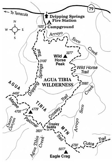
The 20-mile-round-trip hike to the crest and back on Wild Horse Trail and its extension, Crosley Trail, is obviously too far for casual hikers. Perhaps better (and highly recommended if the air is transparently clear) is the shorter, steeper summit climb on Dripping Springs Trail -- 14 miles round trip. Don't let this distance deter you; just climb as far as you like. The higher you go, the better the view. At two to three miles up, you're treated to a spectacular northern vista of Southern California's highest mountains -- San Antonio (Old Baldy), San Gorgonio, and San Jacinto -- each wearing a snowcap well into the spring season.
At 4.5 miles, the trail descends a little and you'll spot the white dome of the 200-inch Hale Telescope at Palomar Observatory gleaming on a ridge about nine miles southeast. Many hikers turn back at this point. The pine- and oak-fringed summit ridge of Agua Tibia Mountain lies in view ahead -- fair game for energetic day hikers and backpackers.
This article contains information about a publicly owned recreation or wilderness area. Trails and pathways are not necessarily marked. Conditions can change rapidly. Hikers should be properly equipped and have safety and navigational skills. The Reader and Jerry Schad assume no responsibility for any adverse experience.
Here's something you might be interested in.
Explore the flowering slopes of Agua Tibia Wilderness, east of Temecula, at its seasonal best.
Explore the flowering slopes of Agua Tibia Wilderness, east of Temecula, at its seasonal best.
The Agua Tibia Wilderness covers an obscure section of Cleveland National Forest, just east of Temecula, straddling the San Diego-Riverside County line. Agua Tibia's pillowy, steeply plunging, chaparral-clad slopes look austere from a distance — and they are without question not a great place to visit on a hot day in summer or fall. This month, however, the weather remains on the cool side, and the slopes are greening and flowering in response to the somewhat anemic but significant recent rains.
Agua Tibia's only convenient entry point lies along Highway 79, ten miles east of Interstate 15. On the right (south side) of the road you'll find the Dripping Springs Fire Station, the currently closed (reopening in June) Dripping Springs Campground, and a trailhead parking lot for Agua Tibia Wilderness visitors. A National Forest Adventure Pass must be posted on your car here. Entry is free. A camping permit from the forest service is required for overnight stays in the wilderness area. Even if you're hiking for only a few hours, it's critically important that you carry plenty of drinking water. Early spring temperatures can easily reach into the 80s here. Call Cleveland National Forest, 760-788-0250, for more particulars.
After walking south through the campground, you hop across Arroyo Seco Creek on stones, pick up the Dripping Springs Trail, and begin a switchbacking ascent through sage-scrub and chaparral vegetation, liberally sprinkled with a dozen or two kinds of wildflowers. After only 0.1 mile, there's a trail junction. Choose either way: the Wild Horse Trail, on the left, gains elevation relatively slowly. The Dripping Springs Trail, ahead, begins a steady and very crooked ascent of Agua Tibia Mountain's north flank. The "mountain" is actually the westward extension of the long ridge commonly known as Palomar Mountain.
The 20-mile-round-trip hike to the crest and back on Wild Horse Trail and its extension, Crosley Trail, is obviously too far for casual hikers. Perhaps better (and highly recommended if the air is transparently clear) is the shorter, steeper summit climb on Dripping Springs Trail -- 14 miles round trip. Don't let this distance deter you; just climb as far as you like. The higher you go, the better the view. At two to three miles up, you're treated to a spectacular northern vista of Southern California's highest mountains -- San Antonio (Old Baldy), San Gorgonio, and San Jacinto -- each wearing a snowcap well into the spring season.
At 4.5 miles, the trail descends a little and you'll spot the white dome of the 200-inch Hale Telescope at Palomar Observatory gleaming on a ridge about nine miles southeast. Many hikers turn back at this point. The pine- and oak-fringed summit ridge of Agua Tibia Mountain lies in view ahead -- fair game for energetic day hikers and backpackers.
This article contains information about a publicly owned recreation or wilderness area. Trails and pathways are not necessarily marked. Conditions can change rapidly. Hikers should be properly equipped and have safety and navigational skills. The Reader and Jerry Schad assume no responsibility for any adverse experience.
Comments